USE OF GEOSPATIAL TECHNIQUES IN HYDROGEOLOGICAL INVESTIGATIONS: A CASE STUDY FROM PURANDER TALUKA, PUNE DISTRICT, MAHARASHTRA, INDIA. Sampada Joshi***, Vinit Phadnis*, Gaurav Srivastava* & Himanshu Kulkarni** *** Principal, Sinhgad College of Science, Pune-411 041. * Faculty, Department of Geoinformatics, Sinhgad College of Science, Pune-411 041. ** Advanced Center for Water Resources Development & Management, Pune 411021 E-mail: [email protected]Abstract Groundwater forms very crucial source of potable water supply and supplementary irrigation in arid and semi-arid regions of the world. Many of these areas are underlain by “hard rocks” which form heterogeneous aquifers. Aquifer storage is highly variable and so is the discharge; therefore residence time, groundwater storage and aquifer response to drought bear a complex relationship with each other. There is a growing realization and appreciation of the need to develop and manage groundwater resources in sustainable manner. The essential first step however is; good knowledge of groundwater flow system, quantities of water stored, rates and seasonal variability of recharge, quantities of abstraction and likely abstraction rates in future with the quality parameters of the water in use. The study area is two watersheds located in southeastern and eastern parts of Purandar Taluka of Pune district of Maharashtra state (Survey of India Toposheet Nos. 47/J/7/NW and 47/J/7/NE) covering five micro-watersheds admeasuring 14000 hectares. The present case study for Pimpri-Pandeshwar watershed and Pondhe watershed has been carried out defining hydro geological regime based on geological mapping and field studies with emphasis on monitoring wells in terms of water table fluctuation and water chemistry (pH, conductivity, salinity & TDS). The work was carried out with the help of Arc GIS 9.1 which enabled faster and efficient data analysis and creation of various data sets which helped in modeling the regime. The study indicates that in a typical Deccan Volcanic Province, similar looking aquifers show differing values in TDS which could be attributed to the presence of alluvium and anomalies caused by salinity. The water table contour maps generated over three months and subsequent field visit data helped indicate groundwater recharge and discharge zones which would help guide new engineering structures and thus support decision making. Further characterization of these watersheds is being done through continued monitoring and pumping tests. This exercise has not only addressed and analyzed these aspects but has helped educate and sensitize the population of the area in working towards sustainable water management and quality parameters.
Transcript
USE OF GEOSPATIAL TECHNIQUES IN HYDROGEOLOGICAL INVESTIGATIONS: A CASE STUDY FROM PURANDER TALUKA, PUNE DISTRICT, MAHARASHTRA, INDIA.
Sampada Joshi***, Vinit Phadnis*, Gaurav Srivastava* & Himanshu Kulkarni** *** Principal, Sinhgad College of Science, Pune-411 041. * Faculty, Department of Geoinformatics, Sinhgad College of Science, Pune-411 041. ** Advanced Center for Water Resources Development & Management, Pune 411021 E-mail: [email protected]
Abstract
Groundwater forms very crucial source of potable water supply and supplementary irrigation
in arid and semi-arid regions of the world. Many of these areas are underlain by “hard rocks”
which form heterogeneous aquifers. Aquifer storage is highly variable and so is the
discharge; therefore residence time, groundwater storage and aquifer response to drought
bear a complex relationship with each other.
There is a growing realization and appreciation of the need to develop and manage
groundwater resources in sustainable manner. The essential first step however is; good
knowledge of groundwater flow system, quantities of water stored, rates and seasonal
variability of recharge, quantities of abstraction and likely abstraction rates in future with the
quality parameters of the water in use.
The study area is two watersheds located in southeastern and eastern parts of Purandar Taluka of Pune district of Maharashtra state (Survey of India Toposheet Nos. 47/J/7/NW and
47/J/7/NE) covering five micro-watersheds admeasuring 14000 hectares. The present case
study for Pimpri-Pandeshwar watershed and Pondhe watershed has been carried out defining
hydro geological regime based on geological mapping and field studies with emphasis on
monitoring wells in terms of water table fluctuation and water chemistry
(pH, conductivity, salinity & TDS). The work was carried out with the help of Arc GIS 9.1
which enabled faster and efficient data analysis and creation of various data sets which
helped in modeling the regime.
The study indicates that in a typical Deccan Volcanic Province, similar looking aquifers
show differing values in TDS which could be attributed to the presence of alluvium and
anomalies caused by salinity. The water table contour maps generated over three months and
subsequent field visit data helped indicate groundwater recharge and discharge zones which
would help guide new engineering structures and thus support decision making. Further
characterization of these watersheds is being done through continued monitoring and
pumping tests.
This exercise has not only addressed and analyzed these aspects but has helped educate and
sensitize the population of the area in working towards sustainable water management and
quality parameters.
Introduction Groundwater is the major source of drinking water both in urban and rural India. Being an
important and integral part of the hydrological cycle, its availability depends on the rainfall,
recharge and discharge conditions. Until recently, it had been considered a dependable source
of uncontaminated water. In India, groundwater has played the pivotal role in fulfilling the
demands of domestic, industrial and agriculture sectors. The measures need to be adopted in
the country to meet the increased water demand.
The geological history of Maharashtra is largely confined by the Deccan Basaltic Province-
An important geological feature of Penisular India extending over an area of about 5,00,000
Km2. These are essentially composed of subhorizontal sheet of basaltic flows and associated
pyroclast.Deccan volcanic Province of India offers a unique hydrogeological setting. The
type of basalt, its degree of weathering, and the nature and intensity of fracturing control the
occurrence and movement of groundwater resources in the Deccan basalt (Adyalkar and
Mani, 1971; Deolankar, 1980; Kulkarni et al, 2000). The work has been carried with the
help of Arc GIS 9.1 which enabled faster and efficient data analysis and creation of various
data sets which helped in modeling the regime.
Study Area:
The study area is two watersheds located in southeastern and eastern parts of Purandar Taluka of Pune district of Maharashtra state (Survey of India Toposheet Nos. 47/J/7/NW and 47/J/7/NE) covering five micro-watersheds admeasuring 14000 hectares.
Pimpri –Pandeshwar & Pondhe watershed:
Pandeshwar is a small village situated in the southeastern parts of Purandar Taluka of Pune
district of Maharashtra state. The watershed is located about 20 km from Jejuri Township in
Purandar Taluka. The mean average elevation of the watershed is 715 m above mean sea
level and the realistic annual rainfall is 400mm.The Project area covers five micro-
watersheds admeasuring about 140 km2 (14000 hectares).
Pondhe village lies in the eastern most parts of Purundar Tehsil of Pune district of
Maharashtra state marking the western divide of the watershed. The area is bounded by
latitudes 18º 25’ N and 18º 27’30’’ N and by the longitudes 74º 15’ E and 74º 17’30’’ E.
Rainfall shortage and large-scale groundwater overabstraction have plagued this village for
the last decade. Annual rainfall is in the range of 300 to 450 mm and occurs over a period
between June and October. The mean average elevation of the watershed is 730 m above
MSL.
Hydro geology of the area:
Pandeshwar and Pondhe watersheds are underlain by Deccan Trap basalts. These lava
‘flows’ vary in thickness from a few meters up to 10s or even 100s of meters. Each lava flow
can further be divided into sub-units. In general, the Deccan basalts can be grouped into two
categories, ‘simple’ or ‘compound’ depending on the viscosity of the primary lava
(Deshmukh, 1988; Kale and Kulkarni, 1992). Basalt lavas from the area have been depicted
dominantly as ‘aa’’ lava flows belonging to the Deveghat formation (GSI, 200).
The basaltic rocks constitute the primary physical framework for both Pimpri-pandeshwar
and Pondhe watershed, which have been, traversed by fractures at places. The overall
hydrological and hydrogeological environment is essentially a “hard-rock” domain
possessing low porosity and permeability or hydraulic conductivity (Macdonald et al, 1995).
They constitute groundwater systems showing uncertain well yields with an overall low
aquifer-storage potential.
Vesicular amygdaloidal basalt unit II (VAB II) and compact basalt unit III (CB III), vesicular
amygdaloidal basalt unit III (VAB III) and compact basalt unit IV (CB IV) and vesicular
amygdaloidal basalt unit IV (VAB IV) and compact basalt unit V (CB V) show
characteristics of forming shallow groundwater systems in areas where these are respectively
exposed at the surface. However, CB IV, which is the compact basalt unit exposed in the
central part of the watershed is of considerable thickness, at places exceeding 30 m. The
upper portions (< 10 m) are often subvertically jointed attributing some hydraulic
conductivity to the groundwater system (along with VAB III). However, its lower parts
comprise very dense, often unjointed rock, marking an impermeable base for the whole
sequence of units in the watershed.
Hydrogeological monitoring for Pimpri-pandeshwar watershed involved a detailed study of
30 odd large diameter wells while in Pondhe watershed,16 odd large diameter wells were
studied alongwith other aspects such as; study of drainage lines and hydrogeochemical
characters in relation to the local geology.
Geomorphology & Drainage Analysis :
Watershed in the Pimpri-pandeshwaras well as Pondhe region is much gentler in relief as
compared to that from in the Western Ghats in Maharashtra. The regional relief appears quite
subtle, with the younger basalt outcrops standing out as ridges against a gently undulating
and rolling landscape. The Pimpri-pandeshwar watershed gradually slopes towards the
South-East while Pondhe watershed gradually slopes towards the East, the regional slope
being towards the South. With elevations in the range of 790 to 670 m above mean sea level,
the average topographic gradient in the watershed works out to just under 120 m over a
length of 3.07 km (i.e. 1: 25 or 4%). However, slopes are bound to be greater along the flanks
of the low divides in the eastern, northeastern and southern portions of the watershed, where
watershed slope treatment measures would be intensive. In fact, the divide itself is marked by
an almost flat-topped, narrow plateau along the northern, eastern and southern margins. The
central and eastern parts of the watershed occupy valley areas where slopes are much gentler
Regional drainage pattern is sub dendritic. In the watershed, however, its expression is a
weak combination of sub dendritic and rectilinear types, although the area is a part of a larger
subdendritic drainage network feeding the Domaychiwadi tank to the east. Drainage channels
in most of the watershed area are narrow but shallow (deep incisions into bedrock are
uncommon). In the middle reaches, the drainage appears to be structurally controlled. This
may be attributed to the weak fracture zones in the area.
Bifurcation ratios indicate a weak structural control. Structural control may possibly be local
and along fractured zones and the streams are seen to be flowing through areas where surface
permeability is likely to be least. In Pandeshwar watershed, the fifth order streams constitute
the longest arm within the drainage network, indicating two clear-cut controls: gentle (almost
flat) slope and relatively higher permeability of adjoining surfaces.
In Pondhe watershed, the fourth order stream constitutes the longest arm within the drainage
network, indicating two clear-cut controls: gentle (almost flat) slope and relatively higher
permeability of adjoining surfaces.
Some lower order streams join the highest order drainage line almost up to the westernmost
boundary of the watershed. This portion of the drainage channel shows some discharge
throughout the year.
Drainage densities in Pandeshwar and Pondhe watershed are much comparable to those for
fourth order watersheds in the Deccan basalts (ACWADAM, 1999i; Kulkarni, 1991). The
drainage density for the lower portions of the watershed (fourth order stream segment) would
be of exceptionally large magnitude, confirming a drainage morphometry and
geohydrological conditions suitable for better surface permeability.
Data collection and Analysis:
Well No. Location Elevation Depth
Longitude Latitude (m) (m)
PP1 N 18°18'20.5" E74°15'18.5" 639 3.6
PP2 N 18°18'14.9" E74°14'53.4" 642 7.8
PP3 N 18°18'23.7" E74°14'29.1" 648 7.5
PP4 N 18°18'8.2" E74°14'22.8" 640 5.6
PP5 N 18°18'30.8" E74°14'14.5" 643 13.3
PP6 N 18°18'39" E74°14'11.4" 642 14.7
PP7 N 18°18'38.2" E74°14'8.6" 641 7.8
PP8 N 18°18'33.1" E74°14'1.7" 652 6
PP9 N 18°18'45.3" E74°13'57.5" 652 11.6
PP10 N 18°18'48.1" E74°14'14.3" 639 7.7
PP11 N 18°18'41.7" E74°14'24.4" 636 3.9
PP12 N 18°18'31.4" E74°15'1.7" 632 7.2
PP26 N 18°18'30.8" E74°15'31.3" 630 9.65
PP27 N 18°18'38.4" E74°15'10.3" 640 7.9
PP13 N 18°19'3.1" E74°13'48.0" 652 7.6
PP14 N 18°18'57.5" E74°13'41.5" 648 13.3
PP15 N 18°18'53.4" E74°13'37.7" 650 10.8
PP16 N 18°18'54.9" E74°13'30.2" 653 13
PP17 N 18°19'7.7" E74°13'21.7" 652 7.8
PP18 N 18°19'15.5" E74°13'9.2" 657 8
PP19 N 18°19'19" E74°13'9.4" 667 3.9
PP20 N 18°19'33.4" E74°12'58.4" 654 8.4
PP21 N 18°19'28.7" E74°13'14.5" 654 7.6
PP22 N 18°19'22.1" E74°13'19.1" 655 6.3
PP23 N 18°19'17.3" E74°13'26.6" 657 4.7
PP24 N 18°19'10.7" E74°14'41.5" 650 8.2
PP25 N 18°18'52.2" E74°14'8.4" 651 8.05
PP28 N 18°18'31.5" E74°13'18.3" 646 6.7
PP29 N 18°18'32.3" E74°13'33.0" 645 11 PP30 N 18°19'21.5" E74°19'21.5" 664 13.65
Table no. 1: Preliminary water level data Nov’06 to Jan’07
The data was collected from the wells was in form of;
1. Water level in the well in meters.
2. Depth of the well in meters.
3. Surface elevation of each well.
4. Location of the well.
5. Pumping test
Instruments Used during the data collection
• Measuring meter tape for taking the depth and water level for well inventory.
• GPS for taking the location and surface elevation.
Other than these instruments, extensive work was carried out with the help of Arc GIS 9.1 to
enable a faster and efficient data analysis. This exercise also aided in a better understanding
of the Geographical Information Systems and its usage in earth science applications.
The whole process was carried out as;
• Georeferencing of the Toposheets.
• Digitisation of the contours and drainage network with wells.
• Creation of water level surfaces.
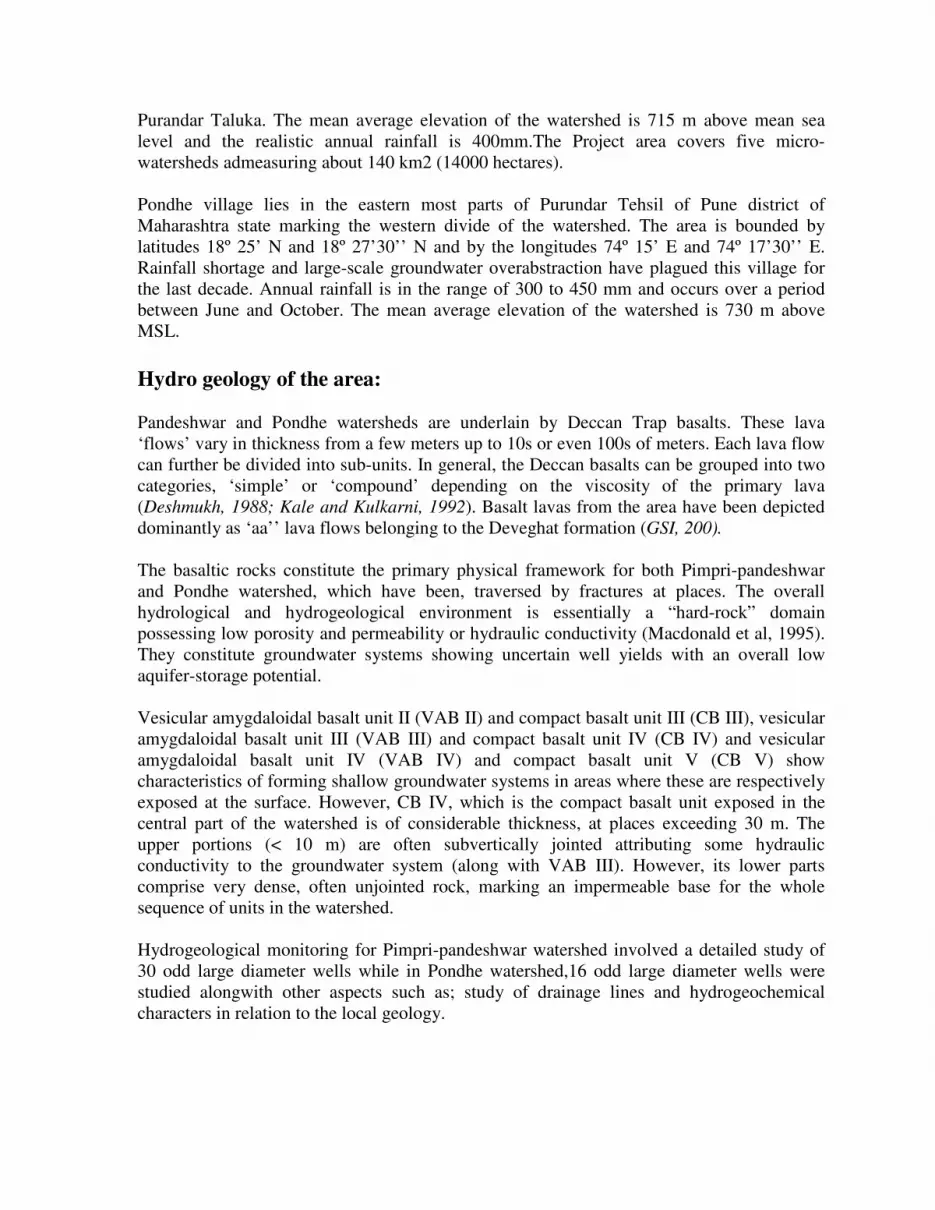
• Spatial analysis
Figure 6: Water table elevations from Pimpri-Pandeshwar area. It is quite clear that groundwater flow is not uniformly distributed. Most of the flow lines if
drawn point a direction towards the southern margin of the watershed indicating the ground
water flow is towards the stream coming from Pimpri. The monthly water level data (for 3
months) is only indicative of the post monsoon distribution of water levels in the area.
Detailed, long term observations will help build on this data, for more concrete inferences.
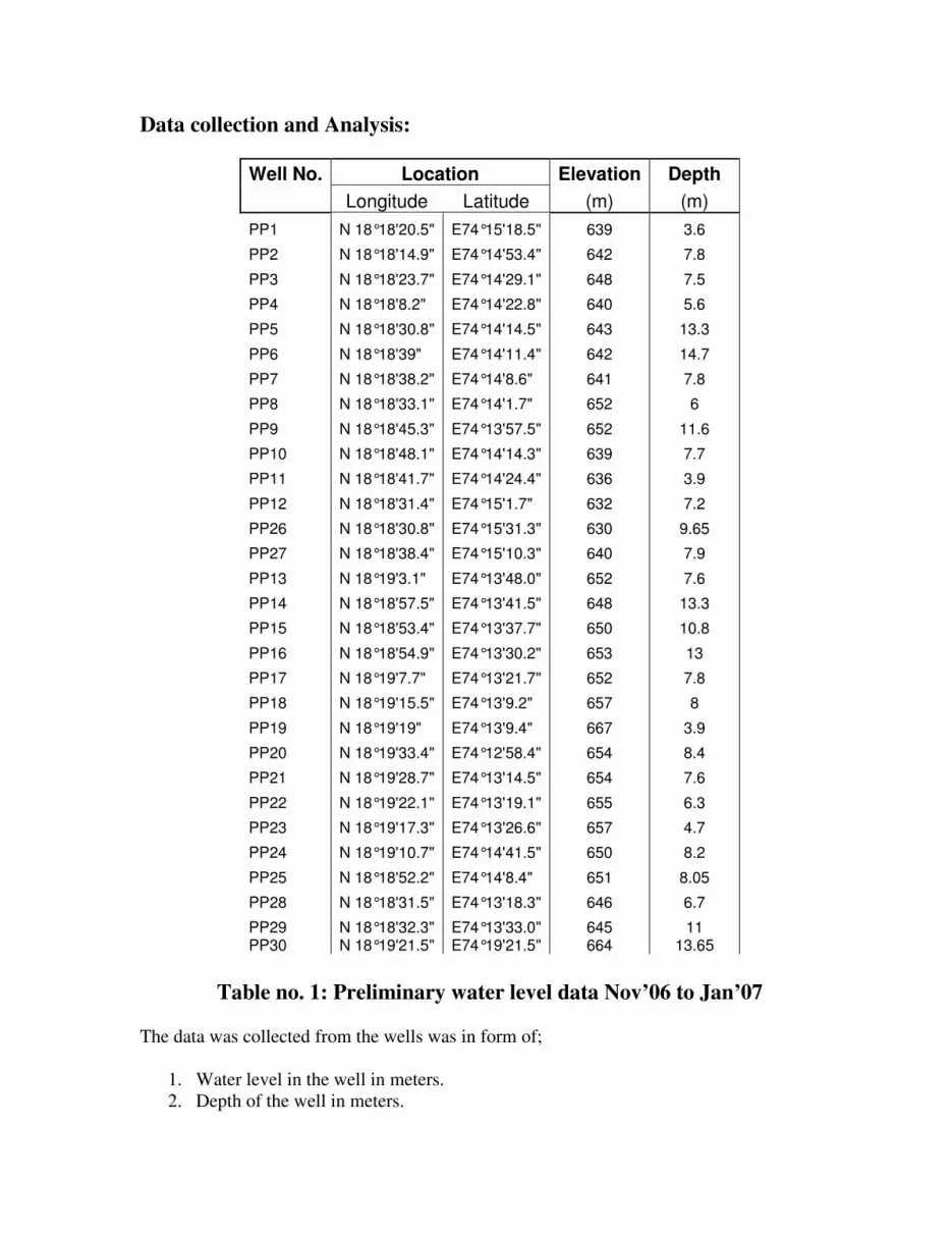
Fig. : Results of geochemical parameters: Pimpri - Pandeshwar watershed
( Dec’ 06 to Feb’ 07).
pH values are in range of 7.2 to 8.4. It means that it is in the range of neutral to alkaline
nature. Salinity is considerably high.(Water quality for irrigation is considered to be
moderate to bad as per USDA classification of irrigation waters.) For drinking water, World
Health Organization (WHO) has set limits of 500 mg/l for the TDS, pH < 8.5. Most of the
wells from the Pimpri-Pandeshwar watershed cross the above said limits of the potable water
with very high salinity as well as EC values.
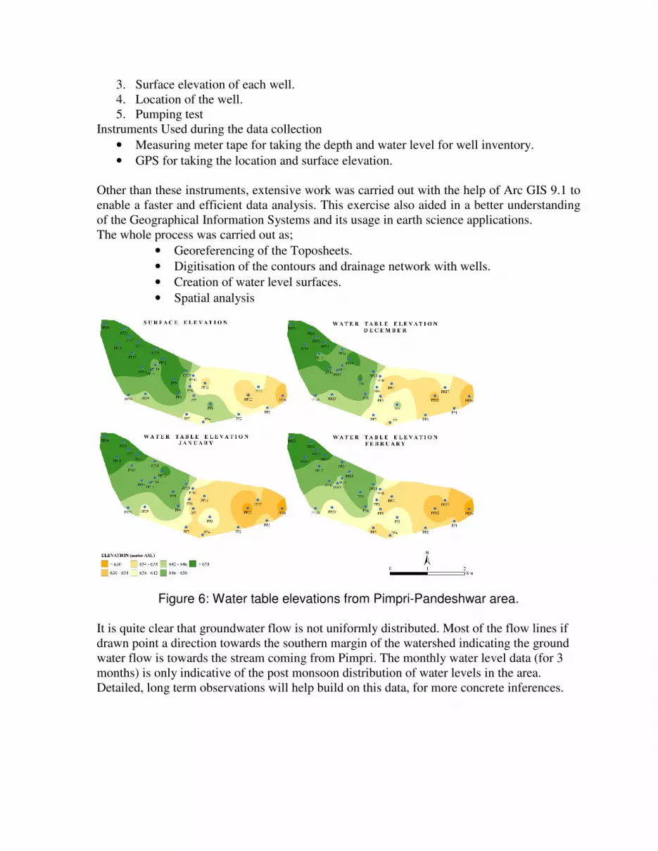
Figure 7: Water table elevations from Pondhe area.
In general water table surfaces are more or less regular. The data indicates that groundwater
flow is almost uniformly distributed. Most of the flow lines if drawn point a direction
towards the southwestern and southeastern margin of the watershed indicating that the
ground water flow is towards the stream moving out of the watershed.
Fig. : Results of geochemical parameters: Pondhe watershed
( Dec’ 06 to Feb’ 07).
pH values are in range of 7.2 to 8.4. It means that it is in the range of neutral to alkaline
nature. Salinity is considerably moderate indicating, the water quality for irrigation to be
good to moderate. For drinking water, World Health Organization (WHO) has set limits of
500 mg/l for the TDS, pH < 8.5.Most of the wells from the Pondhe watershed are well within
limits of the potable water with acceptable salinity as well as EC values
Results & Conclusions:
In a typical Deccan Volcanic Province, similar looking aquifers show differing values in
TDS which could be attributed to the presence of alluvium and anomalies caused by salinity.
High TDS values in Pimpri –Pandeshwar watershed are due to presence of alluvium rather
than hard rocks. While Pondhe watershed shows normal values for pH, salinity as well as
TDS (within permissible limits as per WHO). Baseflow observed in Pimpri –Pandeshwar
watershed is higher than Pondhe watershed indicating that the aquifer is feeding the streams
and water table is higher.
Geospatial techniques were found to be effective means of mapping and analysis as it
enhanced the speed of operations considerably.
The water table contour maps generated over three months and subsequent field visit data
helped indicate groundwater recharge and discharge zones which would help guide new
engineering structures and thus support decision making. Further characterization of these
watersheds is being done through continued monitoring and pumping tests.
ACKNOWLEDGEMENT
We are grateful to ACWADAM and its team for the co-operation , support and guidance extended to
us during this investigation. We thank our geology student team of Siddharth, Anupama, Rohan,
Kaustubh and Veneel for fieldwork and data collection assistance. We express our gratitude to Prof.
M. N. Navale, Founder Secretary STES for his encouragement and providing all infrastructural
facilities.
REFERENCES
ACWADAM (1997) Watershed Analysis for the Khandala Taluka Vikas Pratishthan (an
appraisal of the Hydrogeology and Drainage Characteristics from the Asavali village