Ž . Journal of Volcanology and Geothermal Research 84 1998 125–141 Geochemical and hydrogeological characterization of thermal springs in Western Sicily, Italy R. Favara a , F. Grassa b , S. Inguaggiato a, ) , F. D X Amore c a Istituto di Geochimica dei Fluidi C.N.R. Via Ugo La Malfa, 153, Palermo, Italy b Dipartimento C.F.T.A., UniÕersita di Palermo, Via Archirafi, 36, Palermo, Italy ` c Istituto Internazionale Ricerche Geotermiche C.N.R., P.zza Solferino, 2, Pisa, Italy Accepted 10 April 1998 Abstract Ž . Thermal and cold waters from Castellammare–Alcamo Western Sicily-Italy were collected between May 1994 and May 1995 and studied for their chemical and isotopic composition. During the same period, mean monthly samples of meteoric water were also collected and measured for their isotopic composition. The main purpose of this study was the characterization of the acquifers and, if possible, of their recharge areas. According to the results obtained, the acquifers Ž. Ž. Ž. were divided into three main groups: a selenitic waters, b cold carbonatic waters, and c deep thermal waters resulting from the mixing of the other two types. Besides a mixing process between carbonatic and selenitic waters, contamination processes of thermal waters by seawater take place during their ascent. The water temperature of the acquifer feeding the thermal springs was estimated by means of various geothermometers to range between 608C and 978C. Isotope data on rainwater samples show a wide seasonal variation of both d 18 O and d D values. The fairly constant values of thermal waters through time and the lack of an apparent correlation with the isotopic values of rainwater suggest the existence of a deep circuit determining an almost complete homogenisation of the seasonal variations of the isotopic values. q 1998 Elsevier Science B.V. All rights reserved. Keywords: selenitic waters; cold carbonatic waters; acquifers 1. Introduction Hydrothermal systems are quite common through- out Sicily and the islands lying off it. They can be found on active volcanic islands such as the Aeolian Islands and Pantelleria as well as in the north-eastern Ž . Ž Alı, Acireale, Castroreale , central Termini Imerese, ` ) Corresponding author. Fax: q39-91-6809449; e-mail: [email protected]. Trabia, Cefala Diana, Chiusa Sclafani, S.G. Gemini ` and western sections of the main island. The Sciacca–Montevago thermal springs on the southern coast of Sicily and the Castellammare–Al- camo springs on the northern coast are among the most important systems in Western Sicily. The first studies on Sicilian thermal waters date back to the first half of the last century. More recently Gino and Ž . Sommaruga 1953 discussed the location of the springs and their classification in terms of tempera- Ž ture. Later on, Dall’Aglio 1966, Dall’Aglio and Ž . Ž . Tedesco 1968 , Carapezza et al. 1977 , Dongarra ` 0377-0273r98r$19.00 q 1998 Elsevier Science B.V. All rights reserved. Ž . PII S0377-0273 98 00035-3
Transcript
Ž .Journal of Volcanology and Geothermal Research 84 1998 125–141
Geochemical and hydrogeological characterization of thermalsprings in Western Sicily, Italy
R. Favara a, F. Grassa b, S. Inguaggiato a,), F. DXAmore c
a Istituto di Geochimica dei Fluidi C.N.R. Via Ugo La Malfa, 153, Palermo, Italyb Dipartimento C.F.T.A., UniÕersita di Palermo, Via Archirafi, 36, Palermo, Italy`
Ž .Thermal and cold waters from Castellammare–Alcamo Western Sicily-Italy were collected between May 1994 and May1995 and studied for their chemical and isotopic composition. During the same period, mean monthly samples of meteoricwater were also collected and measured for their isotopic composition. The main purpose of this study was thecharacterization of the acquifers and, if possible, of their recharge areas. According to the results obtained, the acquifers
Ž . Ž . Ž .were divided into three main groups: a selenitic waters, b cold carbonatic waters, and c deep thermal waters resultingfrom the mixing of the other two types. Besides a mixing process between carbonatic and selenitic waters, contaminationprocesses of thermal waters by seawater take place during their ascent. The water temperature of the acquifer feeding thethermal springs was estimated by means of various geothermometers to range between 608C and 978C. Isotope data onrainwater samples show a wide seasonal variation of both d
18O and d D values. The fairly constant values of thermal watersthrough time and the lack of an apparent correlation with the isotopic values of rainwater suggest the existence of a deepcircuit determining an almost complete homogenisation of the seasonal variations of the isotopic values. q 1998 ElsevierScience B.V. All rights reserved.
Hydrothermal systems are quite common through-out Sicily and the islands lying off it. They can befound on active volcanic islands such as the AeolianIslands and Pantelleria as well as in the north-easternŽ . ŽAlı, Acireale, Castroreale , central Termini Imerese,`
.Trabia, Cefala Diana, Chiusa Sclafani, S.G. Gemini`and western sections of the main island.
The Sciacca–Montevago thermal springs on thesouthern coast of Sicily and the Castellammare–Al-camo springs on the northern coast are among themost important systems in Western Sicily. The firststudies on Sicilian thermal waters date back to thefirst half of the last century. More recently Gino and
Ž .Sommaruga 1953 discussed the location of thesprings and their classification in terms of tempera-
Žture. Later on, Dall’Aglio 1966, Dall’Aglio andŽ . Ž .Tedesco 1968 , Carapezza et al. 1977 , Dongarra
0377-0273r98r$19.00 q 1998 Elsevier Science B.V. All rights reserved.Ž .PII S0377-0273 98 00035-3
( )R. FaÕara et al.rJournal of Volcanology and Geothermal Research 84 1998 125–141126
Ž . Ž .and Hauser 1982 , Alaimo et al. 1978, 1990 andŽ .Fancelli et al. 1991 , studied these waters from the
geochemical point of view.The thermal springs in the Castellammare–Al-
camo area are of particular interest for the potentialuse of their low enthalpy fluids because of their
Ž . Ž .temperature ;508C and their flow ;200 lrs .
The aim of this study is the chemical and isotopiccharacterization of these thermal springs, locatingtheir recharge areas and tracing the hydrogeologicalcircuits as for as possible.
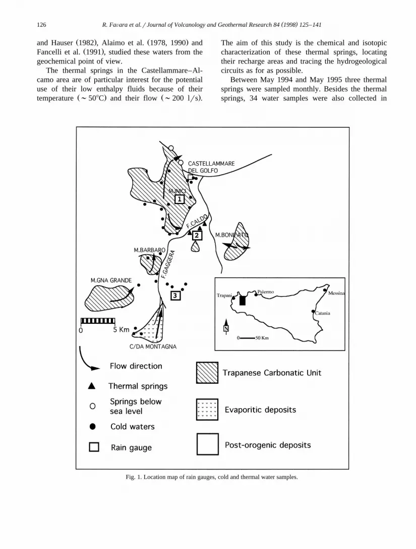
Between May 1994 and May 1995 three thermalsprings were sampled monthly. Besides the thermalsprings, 34 water samples were also collected in
Fig. 1. Location map of rain gauges, cold and thermal water samples.
( )R. FaÕara et al.rJournal of Volcanology and Geothermal Research 84 1998 125–141 127
October 1994 from a selection of cold springs in thesame basin. Mean monthly rainwater samples werealso collected from three rain gauges during 1994–1995. These gauges were located on Mt. Inici at
Ž .different elevations: 1060 m a.s.l. no. 1 , 60 m a.s.l.Ž .no. 2 and 375 m a.s.l. in the town of Calatafimi,Ž .no. 3 . The location of the sampling points and ofthe rain gauges is shown in Fig. 1.
2. Geological and hydrological setting
Sicily can be considered as the southernmost sec-tion of the alpedic orogene in the Mediterranean
Ž .Basin. It consists mainly of two sections: 1 theHyblaean upland with the characteristics of a fore-
Ž .land and crustal similarities with Africa; 2 thechain formed by the south-verging, piling-up of lay-ers, located in the northern part of the island and inthe zone going from the Palermo mountains to the
Ž .Sciacca mountains Catalano and D’Argenio, 1982 .The Caltanissetta and Castelvetrano basins
Ž .Neogene–Pleistocene in age are located south ofthis chain. They have the characteristics of a fore-graben and are filled with terrigenous, evaporitic andcarbonatic sediments reaching a thickness of morethan 1500 m.
The following domains can be distinguished inthe area under study on the basis of stratigraphic,structural and hydrogeological data:
Ž .1 The Trapanese carbonatic domain, formed byplatform limestones, pelagic and marly limestonesranging in age from middle-upper Trias to Eocene.The carbonatic outcrops cover about 250 km2, bothinside the drainage basin and outside the surficialwatershed. The geological complex of this domaincan reach a thickness of about 3000 m, as proven bysome wells drilled for hydrocarbon exploration. Thesedimentary sequence is deeply fractured and karsti-fied so that its medium-high porosity, close to about30%, favours the presence of a massive aquifer.According to a map of the hanging wall formationŽ .Catalano et al., 1983 , and a geologic section from
Ž .Inici to Sciacca Catalano et al., 1982 , the buriedsection of the Trapanese domain spreads over anarea considerably greater than the outcropping. Ahuge deep aquifer may therefore fill up the wholeTrapanese domain. The outcropping carbonatic rocks
belonging to the same unit are the recharge area, andthe vertical continuity of the Trapanese domain al-lows the physical continuity of the water circulation.
Ž . Ž .2 The terrigenous deposits domain include: athe flysch deposits of upper Oligocene-lowerMiocene belonging to the Termini Imerese formationŽ .Catalano and D’Argenio, 1982 . They are consid-ered to be an impermeable formation except for thelimited areas where highly fractured quartzarenites
Ž .crop out; b the late orogenic deposits from theŽCozzo di Terravecchia Formation conglomerates,.sands, clays of fluviodeltaic facies Tortonian to
lower Messinian in age. The hydrogeology of thesedeposits is complex: it is possible, in fact, to distin-
Žguish an upper impermeable section represented by.clays and clayey marls and a lower permeable one
Ž .highly porous sands and conglomerates . AccordingŽ .to Catalano et al. 1983 , the average effective per-
meation is 10% of the precipitation. The contributionof surface waters flowing on impermeable groundmust be taken into consideration in the calculation oftotal permeation. These waters, due to the morpho-logic characteristics of the ground, eventually feedthe underlying aquifer.
Ž .3 The evaporitic deposits domain formed byŽ .organogenic calcarenites Baucina formation , gyp-
sum of the 2nd cycle and limestones of Messinianage. The marked permeability of these deposits isrelated to tectonic disturbances and karst processes.
3. Analytical methods
Water temperature, pH and HCO contents were3
measured directly in the field; HCO was determined3
by titration with HCl 0.1 N. Water samples wereŽ .filtered by means of cellulose filters 0.45 mm and
the major and minor constituents determined byŽDionex 2000i ion chromatograph reproducibility
.within "2% . A Dionex CS-12 column was used forŽ .determining the cations Li, Na, K, Mg, Ca , whereas
a Dionex AS4A-SC column was used for the anionsŽ . Ž .F, Cl, NO , SO Sortino et al., 1991 . DrH water3 4
measurements were carried out using the KendallŽ . Žand Coplen 1985 technique reaction with zinc at
. 18 164508C , while Or O measurements were carriedŽout by the CO –water equilibration technique Ep-2
.stein and Mayeda, 1953 . Mass-spectrometer analy-
( )R. FaÕara et al.rJournal of Volcanology and Geothermal Research 84 1998 125–141128
ses were carried with a Finnigan Mat 250 and aFinnigan Delta S mass spectrometer and the resultsare reported in d per mil units vs. V-SMOW stan-dard. The standard deviations of the measurementsare about "1‰ and "0.2‰ respectively for DrH
18 16 Ž .and Or O measurements 1s .
4. Analytical results and classification of waters
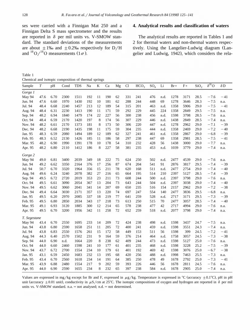
The analytical results are reported in Tables 1 and2 for thermal waters and non-thermal waters respec-
Žtively. Using the Langelier-Ludwig diagram Lan-.gelier and Ludwig, 1942 , which considers the rela-
Table 1Chemical and isotopic composition of thermal springs
18Sample T pH Cond TDS Na K Ca Mg Cl HCO SO Li Br) F) SiO d O d D3 4 2
Ž .Values are expressed in mgrkg except for Br and F, expressed in mgrkg. Temperature is expressed in 8C accuracy "0.18C , pH in pHŽ .unit accuracy "0.01 unit , conductivity in mSrcm at 258C. The isotopic compositions of oxygen and hydrogen are reported in d per mil
units vs. V-SMOW standard. n.a.snot analysed; n.d.snot determined.
()
R.F
aÕara
etal.r
JournalofV
olcanologyand
Geotherm
alResearch
841998
125–
141129
Table 2Chemical and isotopic composition of cold water
18Sample Location Kind Flow Date T pH Cond TDS Na K Ca Mg Cl HCO SO Br) Fl) d O d D3 4Ž .lrs
Ž . Ž .Values are expressed in mgrkg except for Br and F, expressed in mgrkg. Temperature is expressed in 8C accuracy "0.18C , pH in pH unit accuracy "0.01 unit ,conductivity in mSrcm at 258C. The isotopic compositions of oxygen and hydrogen are reported in d per mil units vs. V-SMOW standard. n.a.snot analysed; n.m.snotmeasured. WsWell; SsSpring; RsRiver.
( )R. FaÕara et al.rJournal of Volcanology and Geothermal Research 84 1998 125–141130
( )R. FaÕara et al.rJournal of Volcanology and Geothermal Research 84 1998 125–141 131
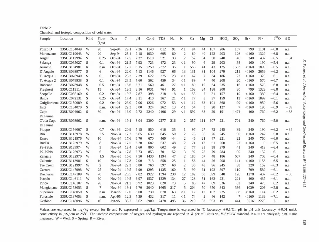
Ž .tive concentrations of major constituents Fig. 2amade a first classification of the sampled waters.
ŽIn agreement with previous studies Carapezza et.al., 1977; Alaimo et al., 1978, 1990 it is possible to
distinguish three different families of groundwaters:Ž .1 cold bicarbonate alkaline-earth waters, similar to
these of meteoric carbonatic recharge;Ž .2 waters belonging to the chlorine-sulphate alka-
Žline-earth field, rich in sulphates selenitic wa-.ters and related to waters flowing through gyp-
sum-sulphurous ground;Ž .3 thermal waters belonging to the chlorine-sulphate
alkaline-earth field, close to the chlorine-sulphatealkaline field.
Using the HCO –SO –Cl ternary diagram of Fig.3 4
2b three possible end-members of mixing can beidentified. One is of marine origin, another one isselenitic and the third is carbonatic. All the studiedthermal waters originate from the mixing of thesethree end-members.
Thermal spring waters show NarCl and BrrClratios close to that representative of seawater. Thissupports the hypothesis that these waters are proba-bly affected by contamination from a cold, shallowercomponent of marine origin. Assuming that the Clcontent of thermal waters is almost totally of seaorigin, and taking into account the Cl content of the
Ž .carbonate cold springs Inicis27.7 mgrkg and ofŽ .the selenitic springs Capo di Fiumes29.1 mgrkg ,
Žthe % of seawater contamination seawaters21.600.mgrkg for the three thermal springs can be evalu-
Ž . Ž .ated close to 3% Gorga 2 , 2% T. Segestane andŽ .1.5% Gorga 1 . Subtracting the contribution from
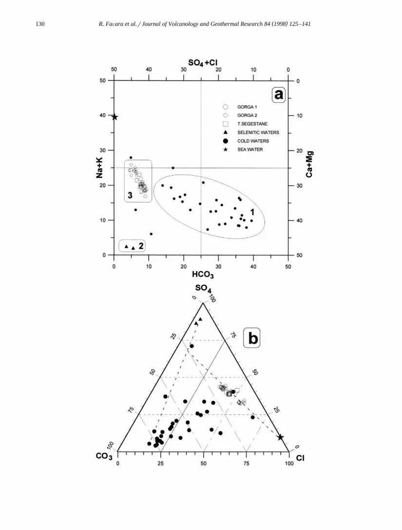
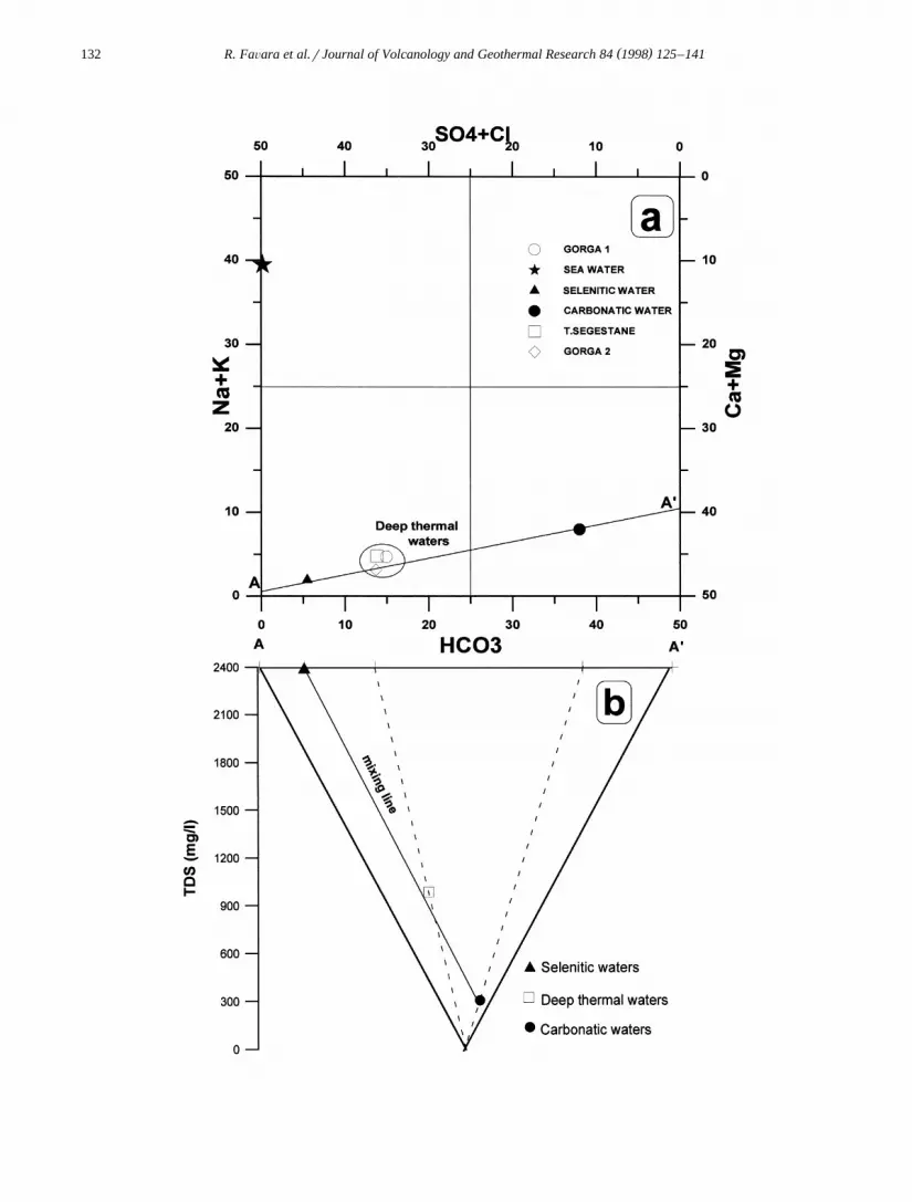
seawater contamination, the average chemical com-position of thermal springs yields the basic chemicalcomposition of deep fluids. According to the homo-geneity of the calculated compositions a single feed-ing reservoir for the three sampled thermal springsŽ .T. Segestane, Gorga 1 e Gorga 2 can be suggested.The chemical composition of the deep-system wa-
Žters, plotted in the Langelier–Ludwig diagram Fig..3a , lies on the line connecting selenitic and carbon-
atic waters, suggesting the existence of a fairly ho-
mogeneous reservoir produced by the mixing ofthese two water families. This mixing is confirmedby the salinity diagram in Fig. 3b reported accordingto section A–AX in Fig. 3a. The three watersŽ .carbonatic, selenitic, and deep thermal are alignedalso in this case. According to this diagram themixing percentages in the thermal reservoir may beestimated to be about 30% selenitic waters and 70%carbonatic waters.
This hypothesis agrees with the conclusions byŽ .Dongarra and Hauser 1982 who found in thermal`
waters sulphur isotope values consistent with anorigin from Messinian evaporites.
The presence of a deep aquifer in which efficienthomogenisation processes take place is also sup-ported by the very narrow range of concentration ofmajor constituents exhibited by the measured sam-ples during the whole hydrological year.
5. Water isotopic composition
5.1. Rainwater
Isotope data of mean rainwater samples collectedŽ .from the three rain gauges, Table 3 show a wide
range of both d18 O and d D seasonal variations.
The heaviest and lightest isotopic values weremeasured in June–July and in October 1994 respec-tively. Both these groups of values are rather pecu-liar since isotopic values close to zero normallyresult from evaporation processes affecting rainwaterdroplets during their fall, while very negative iso-topic values characterize the coldest months, i.e.,December–January. An 18 O and D enrichment ofrainwater related to evaporation processes has beenrepeatedly pointed out by various authors, particu-larly in tropical and subtropical areas. The extremelylight isotopic values obtained in October cannot beeasily explained since, unfortunately, the meanmonthly temperatures at the sites are not availableand, consequently, it is not possible to relate theisotopic values to exceptionally low temperatures orto peculiar meteorological conditions.
Ž . Ž .Fig. 2. a Langelier–Ludwig classification diagram. It is possible to distinguish three water families: carbonatic waters 1 , selenitic watersŽ . Ž . Ž .2 and thermal waters 3 . b Triangular plot Cl–HCO –SO that shows the three water groups and highlights the possible mixing among3 4
Ž .carbonatic, selenitic and sea water end-members dashed lines also reported in the diagram.
( )R. FaÕara et al.rJournal of Volcanology and Geothermal Research 84 1998 125–141132
( )R. FaÕara et al.rJournal of Volcanology and Geothermal Research 84 1998 125–141 133
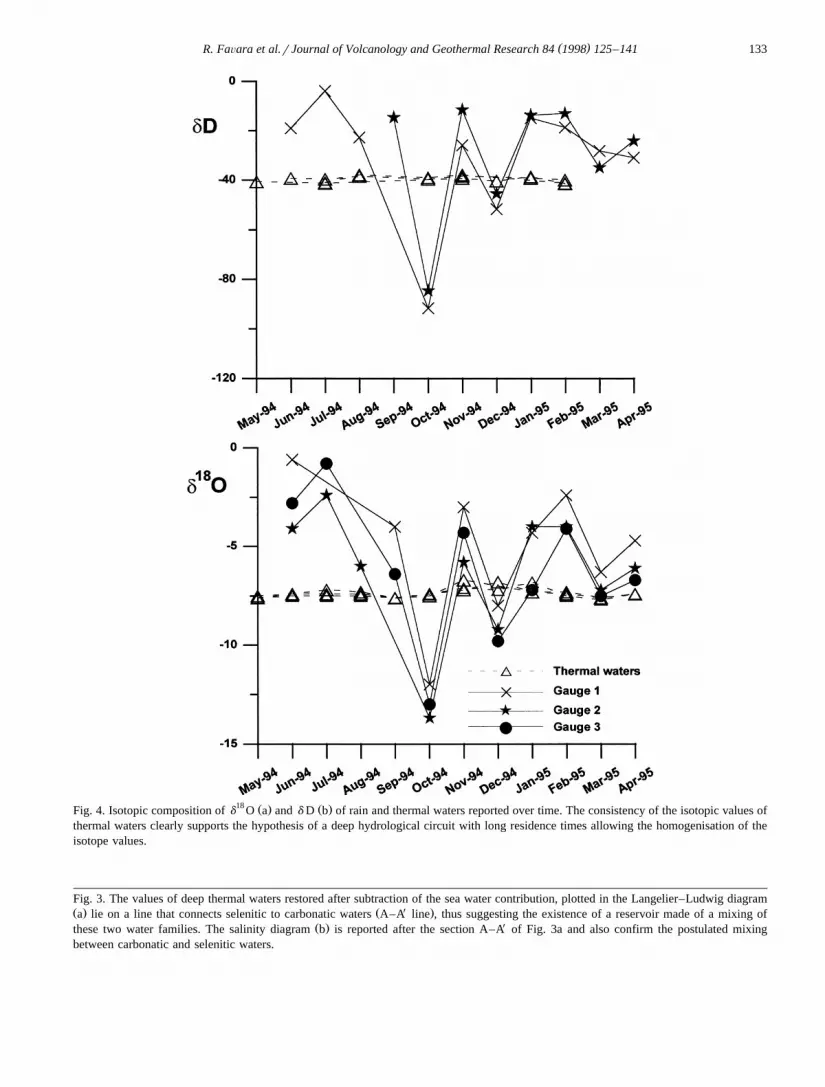
18 Ž . Ž .Fig. 4. Isotopic composition of d O a and d D b of rain and thermal waters reported over time. The consistency of the isotopic values ofthermal waters clearly supports the hypothesis of a deep hydrological circuit with long residence times allowing the homogenisation of theisotope values.
Fig. 3. The values of deep thermal waters restored after subtraction of the sea water contribution, plotted in the Langelier–Ludwig diagramŽ . Ž X .a lie on a line that connects selenitic to carbonatic waters A–A line , thus suggesting the existence of a reservoir made of a mixing of
Ž . Xthese two water families. The salinity diagram b is reported after the section A–A of Fig. 3a and also confirm the postulated mixingbetween carbonatic and selenitic waters.
( )R. FaÕara et al.rJournal of Volcanology and Geothermal Research 84 1998 125–141134
The isotopic characterisation of these rainwatersis mainly related to two effects:
- an elevation effect, observed between rain gauges1 and 2 on the slopes of Mt. Inici.- a continental effect, observed at rain gauge 3.This gauge is 14 km inland, while the other twoare located at about 3 km from the coast.The vertical isotope gradient calculated according
to rain gauges 1 and 2 is 0.21 d18 Or100 m; this
value is quite close both to that calculated by HauserŽ . Ž 18 .et al. 1980 0.20 d Or100 m , and to that
Ž . Ž 18evaluated by Fancelli et al. 1991 0.18 d Or100.m in other areas of Sicily. The continental effect
calculated between gauges 1 and 3 is 0.2 d18 Orkm.
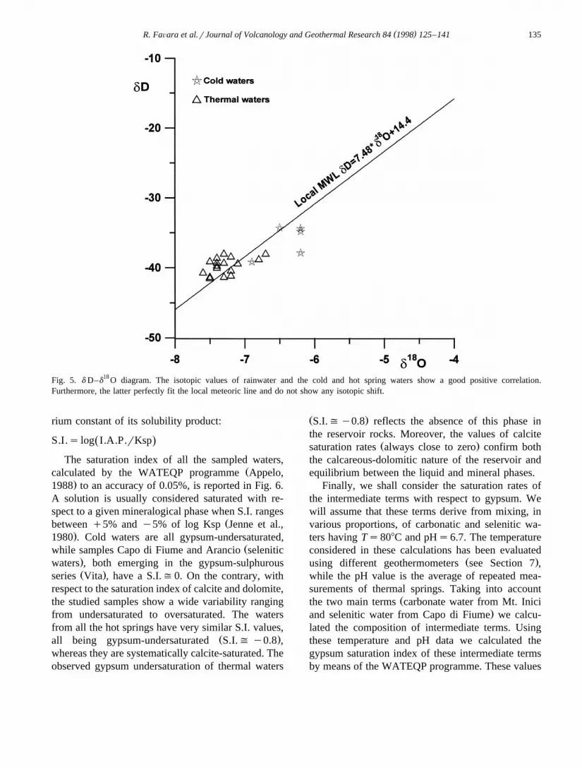
Both d D and d18 O values of rainwater and cold and
thermal water acquifers fit the local meteoric lineŽ 18 . Ž .very well d Ds7.48)d Oq14 Fig. 4 .
5.2. Thermal springs
The isotope data from thermal spring waters areŽ 18almost identical d Osy7.4, y7.3 and y7.3‰
d Dsy40, y39 and y39‰ respectively for Gorga.1, 2 and T. Segestane , thus confirming the hypothe-
sis of a common source feeding water to thesesprings. If we take into account, as previously sug-gested by the chemical composition, that thermalwaters result from the mixing of a carbonatic waterŽ . ŽInici spring with a selenitic water Capo di Fiume
.spring we shall evaluate the isotopic results ob-tained in the light of this hypothesis.
The catchment area of the carbonatic water com-ponent can be located on the carbonatic horsts at amean elevation of 500 m a.s.l., the yearly meanisotopic composition of rain water in this area beingclose to y7.1‰ on the basis of a vertical isotopicgradient of about y0.2 d ‰ per 100 m. The catch-ment area of the selenitic water, despite its meanelevation of only 400 m a.s.l., is characterized by
Ž 18very light isotopic values rain gauge no. 3, d Os. Žy8.2 , probably related to a continental effect Ta-.ble 3 .
The percentage of the two components was evalu-ated to be about 70% carbonate water and 30%selenitic water. According to these percentages, andto the isotopic values previously reported, the meand
18 O which may be evaluated for thermal waters is
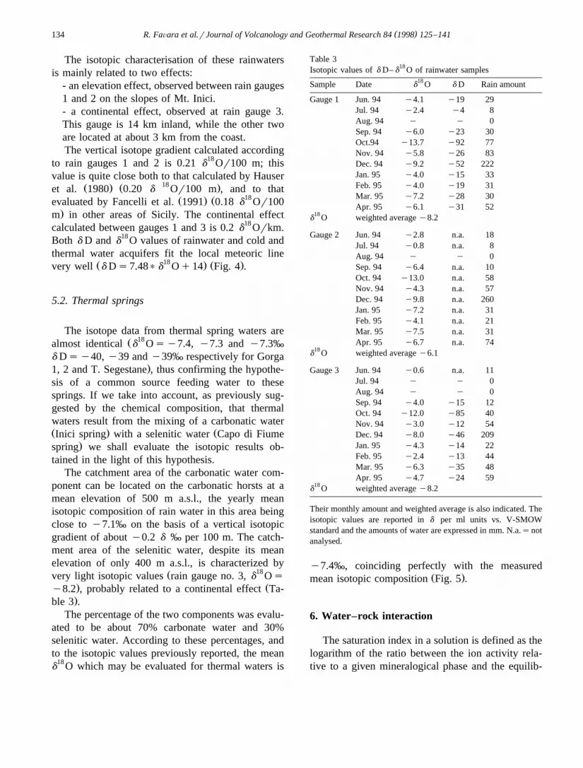
Table 3Isotopic values of d D– d
18 O of rainwater samples18Sample Date d O d D Rain amount
Their monthly amount and weighted average is also indicated. Theisotopic values are reported in d per ml units vs. V-SMOWstandard and the amounts of water are expressed in mm. N.a.snotanalysed.
y7.4‰, coinciding perfectly with the measuredŽ .mean isotopic composition Fig. 5 .
6. Water–rock interaction
The saturation index in a solution is defined as thelogarithm of the ratio between the ion activity rela-tive to a given mineralogical phase and the equilib-
( )R. FaÕara et al.rJournal of Volcanology and Geothermal Research 84 1998 125–141 135
Fig. 5. d D–d18 O diagram. The isotopic values of rainwater and the cold and hot spring waters show a good positive correlation.
Furthermore, the latter perfectly fit the local meteoric line and do not show any isotopic shift.
rium constant of its solubility product:
S.I.s log I.A.P.rKspŽ .The saturation index of all the sampled waters,
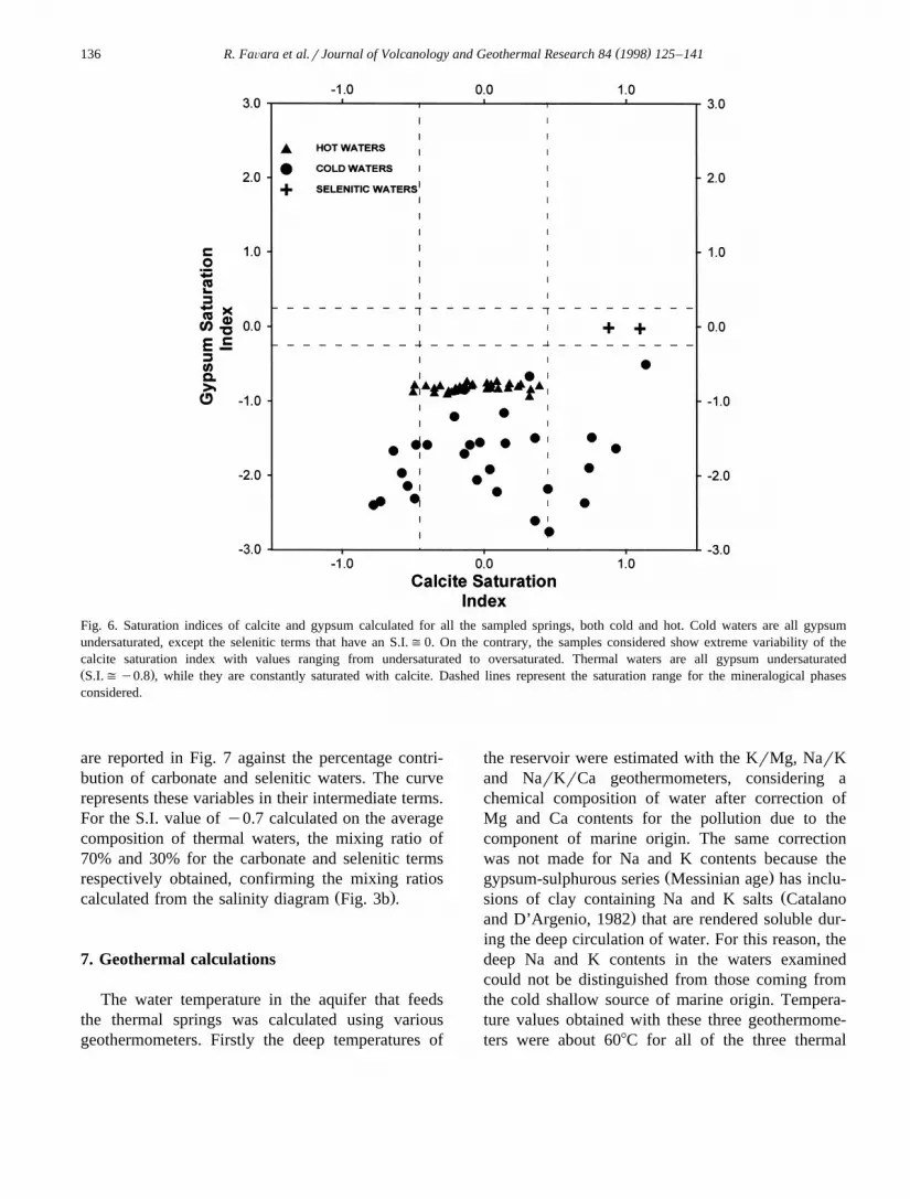
Žcalculated by the WATEQP programme Appelo,.1988 to an accuracy of 0.05%, is reported in Fig. 6.
A solution is usually considered saturated with re-spect to a given mineralogical phase when S.I. ranges
Žbetween q5% and y5% of log Ksp Jenne et al.,.1980 . Cold waters are all gypsum-undersaturated,
Žwhile samples Capo di Fiume and Arancio selenitic.waters , both emerging in the gypsum-sulphurousŽ .series Vita , have a S.I.(0. On the contrary, with
respect to the saturation index of calcite and dolomite,the studied samples show a wide variability rangingfrom undersaturated to oversaturated. The watersfrom all the hot springs have very similar S.I. values,
Ž .all being gypsum-undersaturated S.I.( y0.8 ,whereas they are systematically calcite-saturated. Theobserved gypsum undersaturation of thermal waters
Ž .S.I.(y0.8 reflects the absence of this phase inthe reservoir rocks. Moreover, the values of calcite
Ž .saturation rates always close to zero confirm boththe calcareous-dolomitic nature of the reservoir andequilibrium between the liquid and mineral phases.
Finally, we shall consider the saturation rates ofthe intermediate terms with respect to gypsum. Wewill assume that these terms derive from mixing, invarious proportions, of carbonatic and selenitic wa-ters having Ts808C and pHs6.7. The temperatureconsidered in these calculations has been evaluated
Ž .using different geothermometers see Section 7 ,while the pH value is the average of repeated mea-surements of thermal springs. Taking into account
Žthe two main terms carbonate water from Mt. Inici.and selenitic water from Capo di Fiume we calcu-
lated the composition of intermediate terms. Usingthese temperature and pH data we calculated thegypsum saturation index of these intermediate termsby means of the WATEQP programme. These values
( )R. FaÕara et al.rJournal of Volcanology and Geothermal Research 84 1998 125–141136
Fig. 6. Saturation indices of calcite and gypsum calculated for all the sampled springs, both cold and hot. Cold waters are all gypsumundersaturated, except the selenitic terms that have an S.I.(0. On the contrary, the samples considered show extreme variability of thecalcite saturation index with values ranging from undersaturated to oversaturated. Thermal waters are all gypsum undersaturatedŽ .S.I.(y0.8 , while they are constantly saturated with calcite. Dashed lines represent the saturation range for the mineralogical phasesconsidered.
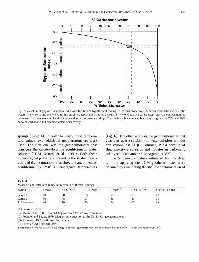
are reported in Fig. 7 against the percentage contri-bution of carbonate and selenitic waters. The curverepresents these variables in their intermediate terms.For the S.I. value of y0.7 calculated on the averagecomposition of thermal waters, the mixing ratio of70% and 30% for the carbonate and selenitic termsrespectively obtained, confirming the mixing ratios
Ž .calculated from the salinity diagram Fig. 3b .
7. Geothermal calculations
The water temperature in the aquifer that feedsthe thermal springs was calculated using variousgeothermometers. Firstly the deep temperatures of
the reservoir were estimated with the KrMg, NarKand NarKrCa geothermometers, considering achemical composition of water after correction ofMg and Ca contents for the pollution due to thecomponent of marine origin. The same correctionwas not made for Na and K contents because the
Ž .gypsum-sulphurous series Messinian age has inclu-Žsions of clay containing Na and K salts Catalano
.and D’Argenio, 1982 that are rendered soluble dur-ing the deep circulation of water. For this reason, thedeep Na and K contents in the waters examinedcould not be distinguished from those coming fromthe cold shallow source of marine origin. Tempera-ture values obtained with these three geothermome-ters were about 608C for all of the three thermal
( )R. FaÕara et al.rJournal of Volcanology and Geothermal Research 84 1998 125–141 137
Fig. 7. Variation of gypsum saturation index as a function of hypothetical mixing, in various proportions, between carbonatic and seleniticŽ .waters at Ts808C and pHs6.7. In this graph we report the value of gypsum S.I. y0.7 relative to the deep reservoir composition, as
calculated from the average chemical composition of the thermal springs. Considering this value we obtain a mixing ratio of 70% and 30%between carbonatic and selenitic waters respectively.
Ž .springs Table 4 . In order to verify these tempera-ture values, two additional geothermometers wereused. The first one was the geothermometer thatconsiders the calcite–dolomite equilibrium in water
Ž .solution TCM, Marini et al., 1986 . Both thesemineralogical phases are present in the studied reser-voir and their saturation rates show the attainment of
Ž .equilibrium S.I.(0 at emergence temperatures
Ž .Fig. 6 . The other one was the geothermometer thatconsiders quartz solubility in water solution, without
Ž .any vapour loss TQC, Fournier, 1973 because offlint insertions as strips and nodules in carbonatic
Ž .lithotypes Catalano and D’Argenio, 1982 .The temperature values estimated for the deep
term by applying the TCM geothermometer wereobtained by eliminating the shallow contamination of
Table 4Measured and calculated temperature values of thermal springs
Ž . Ž . Ž . Ž . Ž .Samples t meas. t SiO A t Ca–Mg B t Mg C t Na–K D t Na–K–Ca E2
Ž .A Fournier, 1973.Ž .B Marini et al., 1986—Ca and Mg corrected for sea water pollution.Ž .C Fournier and Potter, 1979. Magnesium correction to the Na–K–Ca geothermometer.Ž .D Arnosson, 1983, valid for clay minerals.Ž .E Fournier and Truesdell, 1973.Temperature was calculated according to several geothermometers as indicated in the table. Values are expressed in 8C.
( )R. FaÕara et al.rJournal of Volcanology and Geothermal Research 84 1998 125–141138
marine origin; falling within a narrow range between73 and 978C. These data are in agreement with thoseobtained with the TQC geothermometer applied to
Žthe surface thermal component ;808C; see Table.4 . Those estimated temperature values for the three
thermal springs further confirm the hypothesis thatthese springs are fed by a single deep aquifer. Differ-ent supplies of a seawater component received dur-ing upflow can explain the small differences ob-served in chemical composition.
The deep temperature data allow an estimate ofthe theoretical minimum depths of the reservoir by
Ž .using the equation proposed by Desio 1965 :
Ps T yT rGŽ .w a
where: P is the theoretical minimum depth; T isw
the water temperature in the reservoir; T is thea
yearly average air temperature; G is the localgeothermal gradient.
The local geothermal gradient was calculated con-sidering an estimated average value of total heat
Žflow between 1.3 and 1.4 HFU Catalano et al.,.1983 in the area examined. In this case the theoreti-
cal minimum depths of the reservoir are between1300 and 1800 m, which are consistent with thethickness of the Trapanese carbonatic domainŽ .Catalano et al., 1983 .
8. Water budget
An estimate of the groundwater supplies to thebasin was obtained assuming the following waterbudget:
Ps IqRqEŽ .where: P is the amount of precipitation mmryear ;
Ž .I is the amount of water infiltration mmryear ; R isŽ .the rill coefficient of the basin mmryear ; E is the
quantity of water affected by evapotranspirationŽ .mmryear .
On the basis of the data from the local rain gaugenetwork, precipitation was calculated using the
Ž .method proposed by Thiessen 1911 . The pluvio-metric and thermometric values refer to the 1965–1984 period. The calculation of the evapotranspira-tion term was carried out using the equation pro-
Ž .posed by Turc 1955 subsequently modified byŽ .Santoro 1970 for Sicily.
As the data were not sufficient to estimate the rillcoefficient, the effective infiltration was calculatedusing the method of the potential infiltration coeffi-
Ž .cient P.I.C. for the single hydrogeological units, asŽ .proposed by Castany et al. 1970 . In karst areas, the
coefficient of potential infiltration allows a calcula-tion of the percentage of water relative to surfacerun-off and groundwater outflow, representing theassumed effective infiltration:
I sP.I.C.) Deff tot
where: I is the amount of water infiltration; D iseff tot
the total water rill obtained after subtracting E fromŽ .the total amount of precipitation P .
The P.I.C. was defined as a function of a series ofparameters such as lithology, fracturation, acclivity,
Ž .distribution and type of vegetation herbage or tree ,intensity of karst processes. In order to calculate thewater budget, both water capacities and the surplusof the most significant hydrogeological units in theassumed hydrogeological basin were estimated. Table5 reports the data set used to calculate the waterbudget.
The hydrogeological unit of Mt. Inici has a sur-face extension of 18.5 km2 and consists of dolomites
Ž .and limestones Trias–Eocene belonging to the Tra-panese carbonatic platform. The total infiltration is3.23=106 m3, which gives a water capacity of 100
Ž .lrs. The surplus about 70 lrs was obtained byŽ .excluding the known water extraction 30 lrs from
the water capacity. The hydrogeological unit of Mt.Barbaro–Mt. Pispisa has a surface extension of 4.5km2 and consists of calcilutites of the scaglia faciesŽ .Cretaceo–Eocene of the Trapanese domain. Thewater capacity of this unit is about 25 lrs; thesurplus is 20 lrs. The unit of the evaporitic rocksbelongs to the Messinian gypsum-sulphureous seriesand is the recharge area of both superficial and deepselenitic terms. It has a total extension of 16.5 km2
and its water capacity is 85 lrs. The springs and thewells of this area extract about 30 lrs, so the watersurplus is 55 lrs.
The water budget obtained for the hydrologicalunits considered had a water capacity of about 145lrs, that is less than the outflow of all the thermal
Ž .springs 200 lrs . As observed with the chemicaldata, these thermal waters are the result of a mixing
( )R. FaÕara et al.rJournal of Volcanology and Geothermal Research 84 1998 125–141 139
Table 5Computation of the contribution of the meteoric recharge to cold and thermal groundwaters
2Area Lithology km Rainfall P.I.C Meteoric Cold Thermalrecharge groundwaters groundwaters
Mt. Inici dolomite and 18.5 648 85% 100 30 70limestones
Rainfallsamount of meteoric precipitation, expressed in mm. Meteoric recharge, cold groundwaters and thermal groundwaters areexpressed in lrs.
Žbetween two end-members, one carbonatic about. Ž .70% and one selenitic about 30% . Therefore, about
140 lrs are to be ascribed to typically carbonaticŽ .waters and the remaining part 60 lrs to selenitic
waters. If we assume that the entire surplus reachesthe deep aquifer, it is evident that the flow of theselenitic water is sufficient to account for 30% of thetotal flow of the thermal springs. The carbonaticterm, on the contrary, has a water deficiency ofabout 50 lrs so the hydrogeological basin has to beenlarged so as to include other carbonatic hydrogeo-logical units next to the basin examined.
The carbonatic areas to be considered are:Ž .a Mt. Bonifato,Ž .b Montagna Grande.The relief of Mt. Bonifato takes up an area of
8.75 km2. It is composed of the scaglia of Trapanesedomain and has a water capacity of 50 lrs. As thedrainage of groundwaters occurs to the west in thebasin examined and to the east in Calatubo gorge thecontribution to be offered to the deep system mustnot exceed 20 lrs. The mountain complex of Mon-tagna Grande, about 24 km2 wide, consists mainlyof the scaglia of the Trapanese domain. Its watercapacity can be evaluated at about 120 lrs.
Therefore, the water budget deficiency of theŽ .basin studied (50 lrs can be balanced assuming
that part of the estimated water contributions fromMt. Bonifato and Montagna Grande is allowed toflow into the thermal reservoir.
9. Conclusions
The chemical characteristics and the isotope val-ues of d D and d
18 O of the waters considered, as
well as the geological context where they flow andreside, allowed the identification of three main typesof hydrogeological circuits. The first one may be
Žreferred to the selenitic water family rich in sul-.phates , whose feeding area is in the southern portion
of the drainage basin. The second one may be re-ferred to as the cold carbonatic water family, placedunder the principal carbonatic reliefs that constitute
Žthe recharging area Mt. Inici, Mt. Barbaro–Mt..Pispisa . The third, deeper than the other two, is
characterised by a mixing of the above waters andfeeds the thermal springs of the area examined.
The reservoir of this circuit is set in calcareousand dolomitic rocks, as shown by the gypsum andcalcite saturation rates of the waters. The composi-tional ratios in the waters of the thermal springshighlighted the existence of a mixing between threeend members: carbonatic, selenitic and marine-de-rived waters. This mixing occurs in two separatephases:
Ž . Ž .1 mixing between the carbonatic 70% and theŽ .selenitic term 30% in the reservoir, which deter-
mines the hydrothermal term.Ž .2 slight contamination of the mixed thermal
waters with waters of marine derivation during theirupflow. The different percentages of contaminationŽ .1.5–3% are reflected in the small compositional
Ždifferences between the three thermal springs Gorga.1, Gorga 2 and T. Segestane .
The temperatures estimated in the thermal reser-voir, obtained using various geothermometers, arebetween 60 and 978C. The upflow of these thermalwaters occurs along structural discontinuities wherethe loss of load is smaller. In the area studied, infact, there is an active NW–SE fault, which is
( )R. FaÕara et al.rJournal of Volcanology and Geothermal Research 84 1998 125–141140
thought to be responsible for the 1968 earthquake ofBelice.
From the water budget of the basin it is evidentthat the feeding areas of the carbonatic term are thecarbonatic hydrogeological units of Mt. Inici, of Mt.Barbaro–Mt. Pispisa, Mt. Bonifato and MontagnaGrande. The feeding area of the selenitic term, onthe contrary, is to be found in the southern section ofthe basin, where selenitic gypsum of the 2nd cyclecrops out. The water capacity of this hydrogeologicalunit is comparable to the estimated flow of theselenitic portion of the thermal springs. The circula-tion of selenitic waters occurs at first in shallowcircuits, whose limit is represented by the Tortonianclays of the Cozzo di Terravecchia formation. Then,where the impermeable clays are no longer presentunder the selenitic water reservoir, these waters infil-trate through a network of fractures and reach thedeep reservoir, which is assumed to be at a depthranging from 1300 to 1800 m. In the deep reservoirthey mix with the carbonatic waters and reach tem-peratures ranging between 60 and 908C. These tem-
peratures are consistent with a geothermal gradientof about 408Crkm.
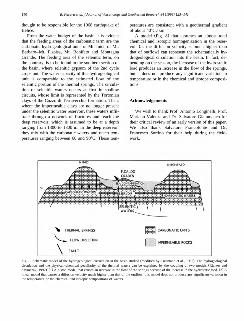
Ž .A model Fig. 8 that assumes an almost totalchemical and isotopic homogenization in the reser-
Žvoir as the diffusion velocity is much higher than.that of outflow can represent the schematically hy-
drogeological circulation into the basin. In fact, de-pending on the season, the increase of the hydrostaticload produces an increase in the flow of the springs,but it does not produce any significant variation intemperature or in the chemical and isotope composi-tions.
Acknowledgements
We wish to thank Prof. Antonio Longinelli, Prof.Mariano Valenza and Dr. Salvatore Giammanco fortheir critical review of an early version of this paper.We also thank Salvatore Francofonte and Dr.Francesco Sortino for their help during the field-work.
Ž .Fig. 8. Schematic model of the hydrogeological circulation in the basin studied modified by Cusimano et al., 1982 . The hydrogeologicalŽcirculation and the physical–chemical peculiarity of the thermal waters can be explained by the coupling of two models Richter and
. Ž . Ž .Szymczak, 1992 . 1 A piston model that causes an increase in the flow of the springs because of the increase in the hydrostatic load. 2 Alinear model that causes a diffusion velocity much higher than that of the outflow, this model does not produce any significant variation inthe temperature or the chemical and isotopic compositions of waters.
( )R. FaÕara et al.rJournal of Volcanology and Geothermal Research 84 1998 125–141 141
References
Alaimo, R., Carapezza, M., Dongarra, G., Hauser, S., 1978.`Geochimica delle sorgenti termali siciliane. Rend. Soc. Chim.
Indagine geochimica sull’acquifero termale della Sicilia occi-dentale. Geologia ed idrogeologia, Bari 25, 101–122.
Appelo, C.A.J., 1988. WATEQP Program. Instituut voor Aard-wetenschappen, Vrije Universiteit, Amsterdam.
Arnosson, S., 1983. The chemistry of geothermal waters in Ice-land: I. Calculation of aqueous speciation from 08C to 3708C.Geochim. Cosmochim. Acta 46, 1513–1532.
Carapezza, M., Cusimano, G., Liguori, V., Alaimo, R., Dongarra,`G., Hauser, S., 1977. Nota introduttiva allo studio delle sor-genti termali dell’isola di Sicilia. Boll. Soc. Geol. Ital. 96,813–836.
Castany, G., Margat, J., Albinet, 1970. Evaluation rapide desressources en eaux d’une region. Atti I Convegno Int. AcqueSotterranee, Palermo.
Catalano, R., D’Argenio, B., 1982. Schema geologico della Siciliaoccidentale. In: Guida alla geologia della Sicilia occidentaleŽ .Ed. , Soc. Geol. Ital. 18 Centenario della societa geologica`italiana.
Catalano, R., Macaluso, T., Monteleone, S., Calandra, D., 1982.Introduzione allo studio delle potenzialita geotermiche della`Sicilia Occidentale. In: Guida alla geologia della Sicilia occi-
Catalano, R., Macaluso, T., Monteleone, S., Calandra, D., 1983.Lineamenti geostrutturali ed idrogeologici e geotermici dellaSicilia occidentale. CNR-PFE-RF13.
Ž .lammare del Golfo Trapani ’. Rend. Soc. Geol. Ital. 5, 31–34.Dall’Aglio, M., 1966. Rilievo geochimico della Sicilia occiden-
tale. Riv. Min. Sicil. 100–102, 175–192.Dall’Aglio, M., Tedesco, C., 1968. Studio geochimico ed idrogeo-
logico di sorgenti della Sicilia. Riv. Min. Sicil. 112–114,171–210.
Desio, A., 1965. Il problema delle acque sotterranee in Italia. AttiConv. Probl. Acque in Italia, F.A.S.T. Milano.
Dongarra, G., Hauser, S., 1982. Isotopic composition of dissolved`sulphate and hydrogen sulphide from some thermal springs of
Ž .Sicily. Geothermics 11 3 , 193–200.Epstein, S., Mayeda, T., 1953. Variation of 18 O content of water
from natural sources. Geochim. Cosmochim. Acta 4, 213–224.
Fancelli, R., Monteleone, S., Nuti, S., Pipitone, G., Rini, S., Taffi,L., 1991. Nuove conoscenze idrogeologiche e geotermichenella Sicilia occidentale. Geologia ed idrogeologia, Bari 26,25–38.
Fournier, R.O., 1973. Silica in thermal waters: Laboratory andfield investigations. In: Proceedings, International Symposiumon Hydrogeochemistry and Biogeochemistry, Tokyo, 170, Vol.1, Hydrogeochemistry, Washington, DC, Clark, pp. 122–129.
Fournier, R.O., Truesdell, A.H., 1973. An empirical Na–K–Cageothermometer for natural waters. Geochim. Cosmochim.Acta 37, 515–525.
Gino, G.F., Sommaruga, C., 1953. Le manifestazioni idrotermalidella Sicilia. Riv. Min. Sicil. 22–23, 172–183.
Hauser, S., Dongarra, G., Favara, R., Longinelli, A., 1980. Com-`posizione isotopica delle pioggie in Sicilia. Riferimenti di baseper studi idrogeologici e relazione con altre aree mediterranee.
Ž .Rend. Soc. Ital. Min. e Petr. 36 2 , 671–680.Jenne, E.A., Ball, J.W., Burchard, J.M., Vivit, D.V., Barks, J.H.,
1980. Geochemical modeling: apparent solubility controls onBa, Zn, Cd, Pb and F in waters of Missouri tri-State mining
Ž .area. In: Heniphill, D.D. Ed. , Trace Sustances in Environ-mental Health, University of Missouri, Columbia. 14, pp.353–361.
Kendall, C., Coplen, T.B., 1985. Multisample conversion of waterto hydrogen by zinc for stable isotope determination. Anal.Chem. 57, 1437–1440.
Langelier, W.F., Ludwig, H.F., 1942. Graphical methods forindicating the mineral character of natural waters. JAWWA34, 335.
Marini, L., Chiodini, G., Cioni, R., 1986. New geothermometersfor carbonate-evaporite geothermal reservoirs. Geothermics15, 77–86.
Santoro, M., 1970. Sull’applicabilita della formula del Turc per il`calcolo della evapotraspirazione effettiva in Sicilia. Atti IConvegno Int. Acque Sotterranee, Palermo-Italy.
Sortino, F., Inguaggiato, S., Francofonte, S., 1991. Determinationof HF, HCl, and total sulphur in fumarolic fluids by ionchromatography. Acta Vulcanol. 1, 89–91.
Thiessen, A.H., 1911. Precipitation average for large areas.Monthly Weather Rev. 3, 45–81.
Turc, L., 1955. Le bilan d’eau des sols. Relation entre les precipi-tations, l’evaporation et l’ecoulement. Ann. Agron. 5, 1–131.