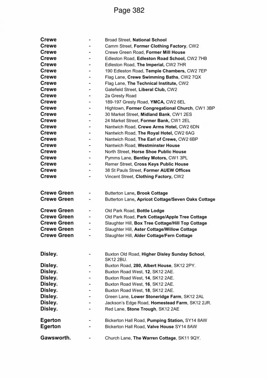
For any apologies or requests for further information, or to arrange to speak at the meeting Contact: Sarah Baxter Tel: 01270 686462 E-Mail: [email protected]Strategic Planning Board Agenda Date: Wednesday, 14th July, 2010 Time: 2.00 pm Venue: The Capesthorne Room - Town Hall, Macclesfield SK10 1DX The agenda is divided into 2 parts. Part 1 is taken in the presence of the public and press. Part 2 items will be considered in the absence of the public and press for the reasons indicated on the agenda and at the foot of each report. Please note that members of the public are requested to check the Council's website the week the Strategic Planning Board meeting is due to take place as Officers produce updates for some or for all of the applications prior to the commencement of the meeting and after the agenda has been published. PART 1 – MATTERS TO BE CONSIDERED WITH THE PUBLIC AND PRESS PRESENT 1. Apologies for Absence To receive any apologies for absence 2. Declarations of Interest/Pre-Determination To provide an opportunity for Members and Officers to declare any personal and/or prejudicial interests and for Members to declare if they have made a pre- determination in respect of any item on the agenda 3. Minutes of the Previous Meeting (Pages 1 - 4) To approve the minutes of the meeting held on 23 June 2010 4. Public Speaking A total period of 5 minutes is allocated for each of the planning application for Ward Councillors who are not members of the Strategic Planning Board. A period of 3 minutes is allocated for the each of the planning application for the following individuals/groups: Public Document Pack
Transcript
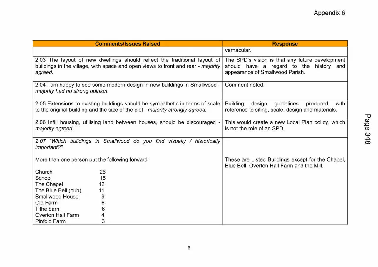
For any apologies or requests for further information, or to arrange to speak at the meeting Contact: Sarah Baxter Tel: 01270 686462 E-Mail: [email protected]
Strategic Planning Board
Agenda
Date: Wednesday, 14th July, 2010
Time: 2.00 pm
Venue: The Capesthorne Room - Town Hall, Macclesfield SK10 1DX The agenda is divided into 2 parts. Part 1 is taken in the presence of the public and press. Part 2 items will be considered in the absence of the public and press for the reasons indicated on the agenda and at the foot of each report. Please note that members of the public are requested to check the Council's website the week the Strategic Planning Board meeting is due to take place as Officers produce updates for some or for all of the applications prior to the commencement of the meeting and after the agenda has been published. PART 1 – MATTERS TO BE CONSIDERED WITH THE PUBLIC AND PRESS PRESENT
1. Apologies for Absence To receive any apologies for absence
2. Declarations of Interest/Pre-Determination To provide an opportunity for Members and Officers to declare any personal and/or
prejudicial interests and for Members to declare if they have made a pre-determination in respect of any item on the agenda
3. Minutes of the Previous Meeting (Pages 1 - 4) To approve the minutes of the meeting held on 23 June 2010
4. Public Speaking
A total period of 5 minutes is allocated for each of the planning application for Ward Councillors who are not members of the Strategic Planning Board.
A period of 3 minutes is allocated for the each of the planning application for the following individuals/groups:
Public Document Pack
• Members who are not members of the Strategic Planning Board and are not the Ward Member
• The relevant Town/Parish Council
• Local Representative Group/Civic Society
• Objectors
• Supporters
• Applicants
5. 09/1018C - Bridestones Shopping Centre, Victoria Street, Congleton, CW12 1DA: Full Planning Application for the Erection of an Extension to the Bridestones Centre comprising a Food Store, Speciality A1 Retail Units, Car Parking and Servicing Facilities and Creation of a Town Square for Modus Congleton Ltd c/o HOW Planning Ltd, 40 Peter Street, Manchester (Pages 5 - 42)
To consider the above planning application
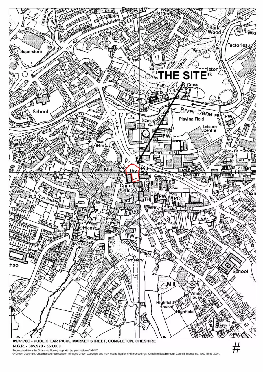
6. 09/4176C - Public Car Park, Market Street, Congleton: Change of Use of Part of
the Fairground Car Park for Temporary Market and Car Boot Sales Uses for HOW Planning Ltd, 40 Peter Street, Manchester (Pages 43 - 48)
To consider the above planning application
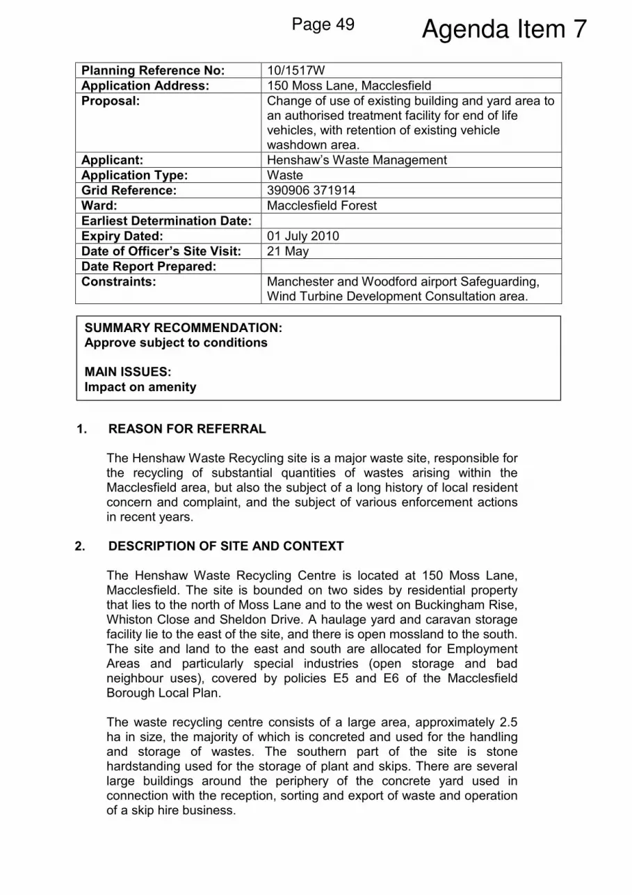
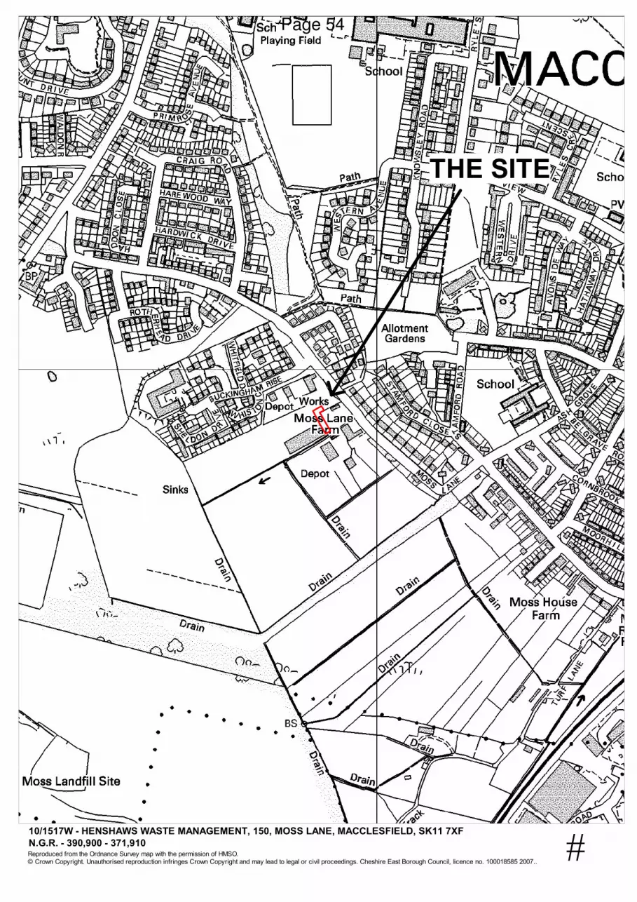
7. 10/1517W - 105 Moss Lane, Macclesfield: Change of Use of Existing Building
and Yard Area to an Authorised Treatment Facility for End of Life Vehicles, with Retention of Existing Vehicle Wash Down Area for Henshaw's Waste Management (Pages 49 - 54)
To consider the above planning application
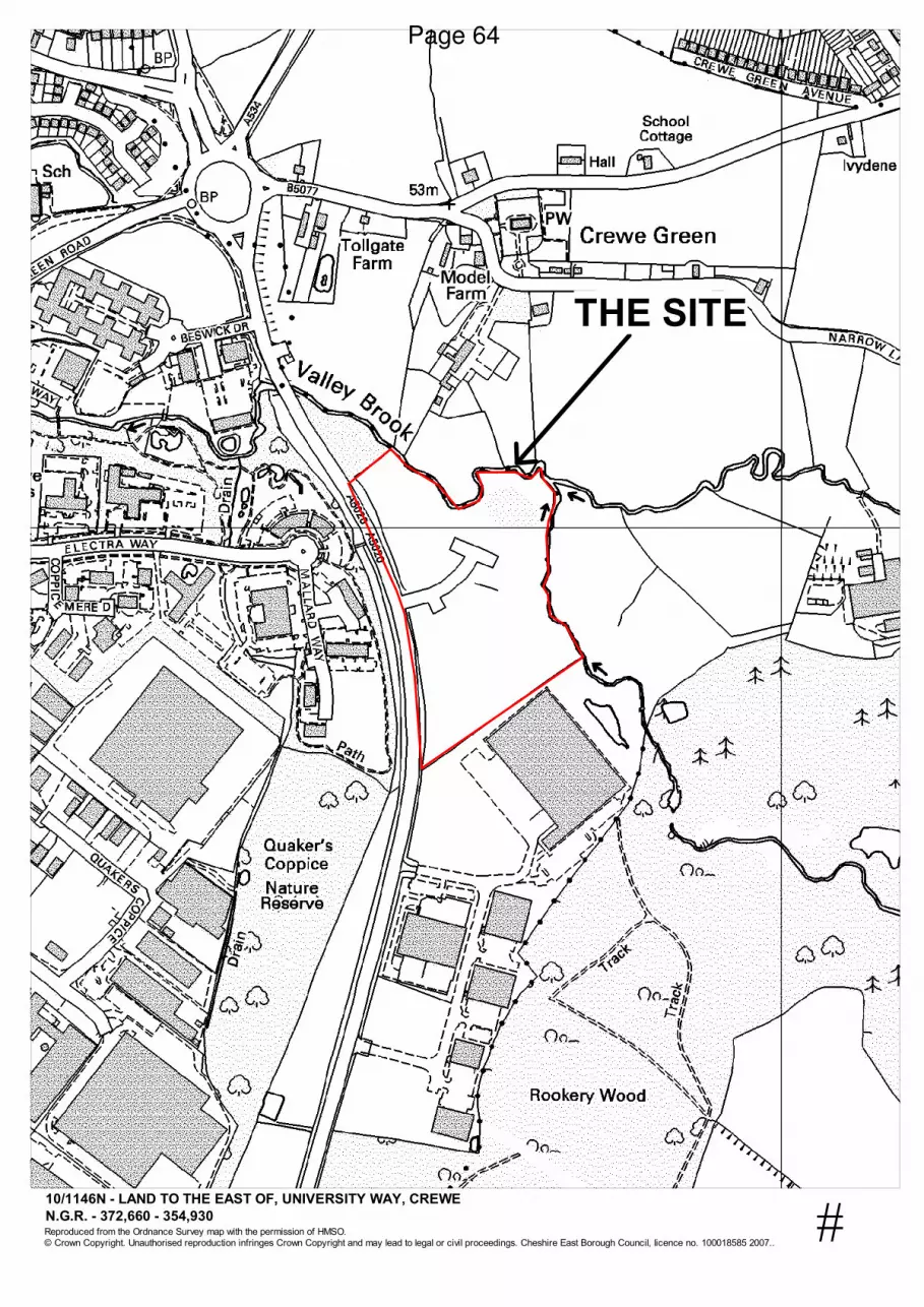
8. 10/1146N - Land to the East of University Way, Crewe: Extension in Time Limit
for the Outline Application for the Erection of Five Office Buildings with Associated Car Parking and Landscaping for Pegasus Planning Group (Pages 55 - 64)
To consider the above planning application
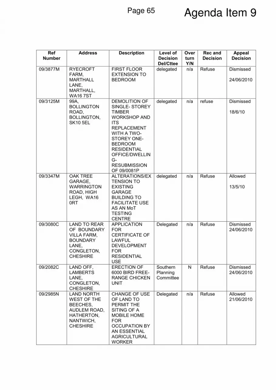
9. Appeal Summaries (Pages 65 - 66) To note the Appeal Summaries
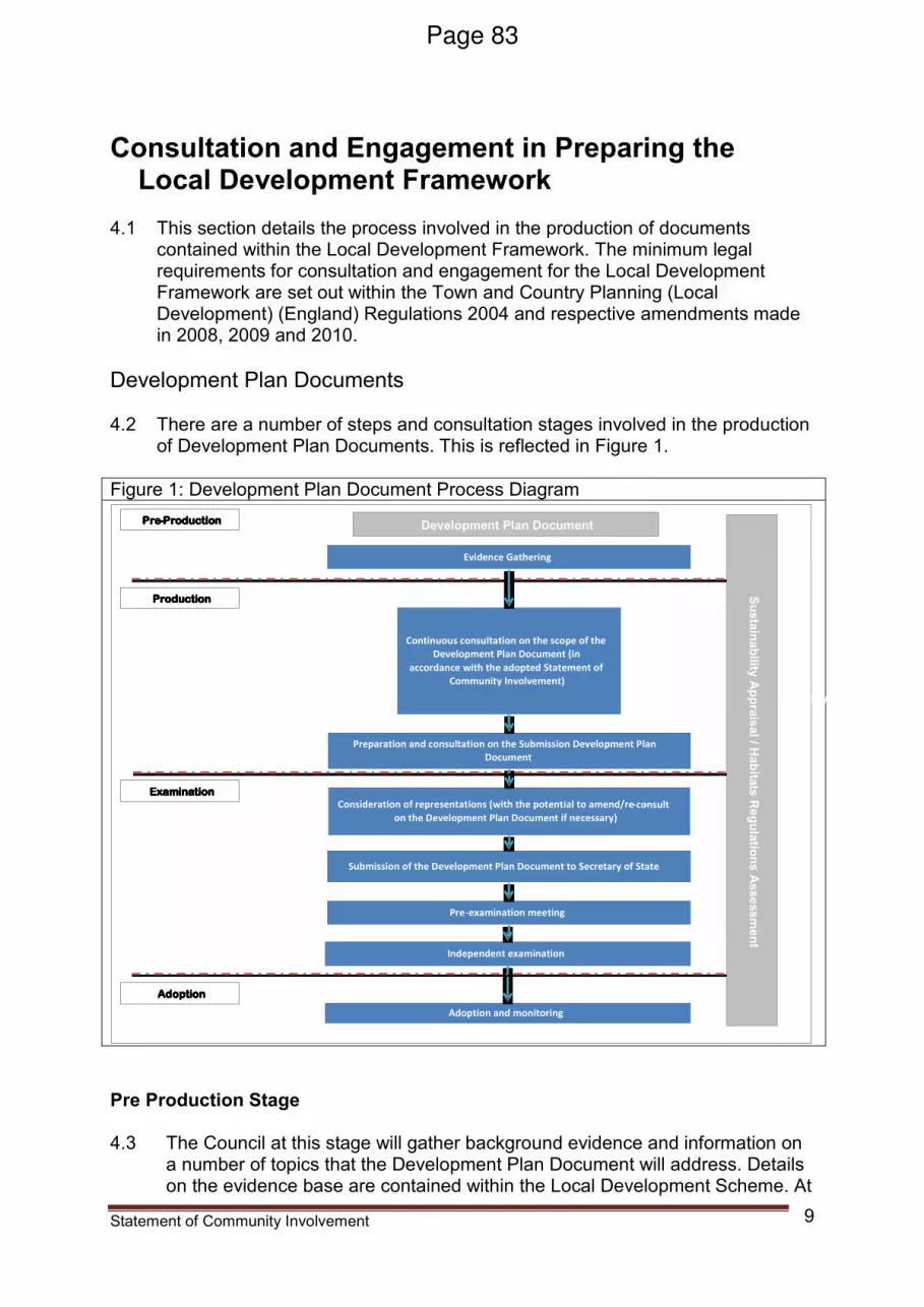
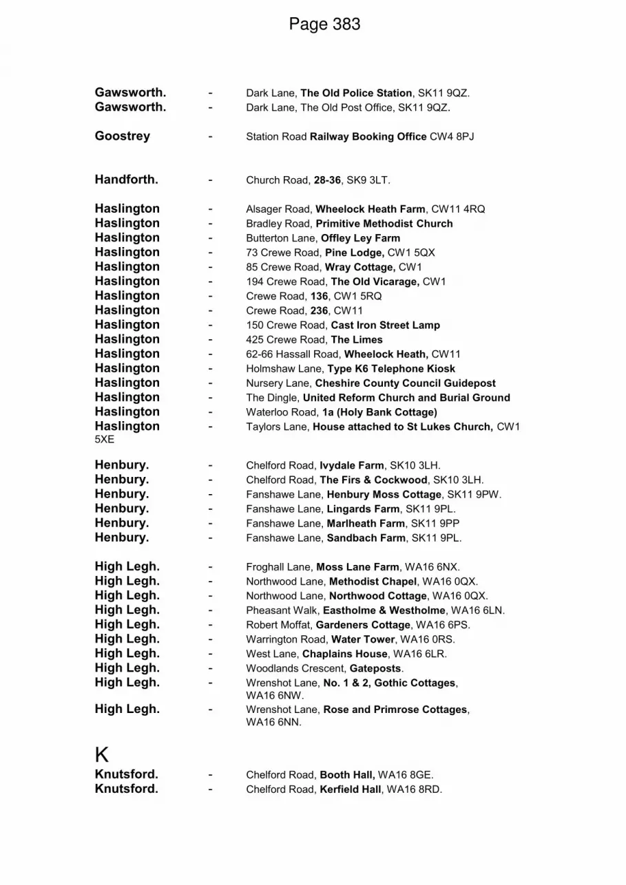
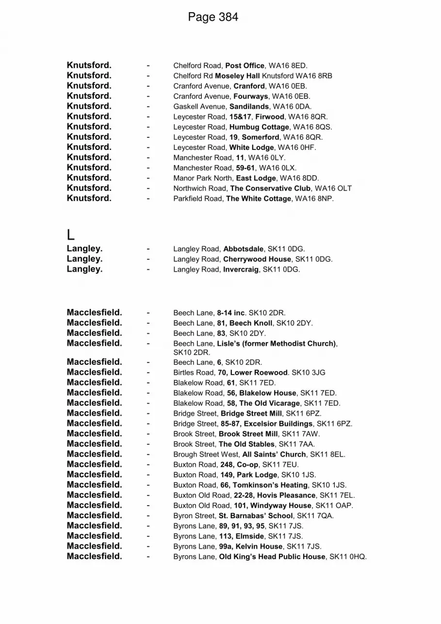
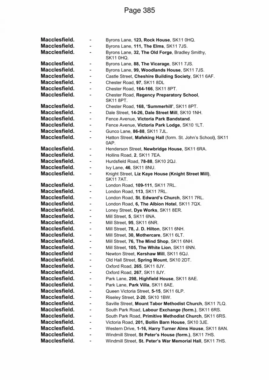
10. Local Development Framework (Pages 67 - 418) To consider the above report
There are no Part 2 Items
CHESHIRE EAST COUNCIL
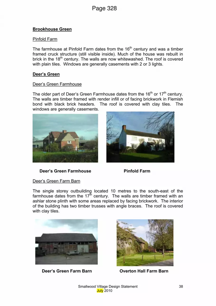
Minutes of a meeting of the Strategic Planning Board held on Wednesday, 23rd June, 2010 at The Capesthorne Room - Town Hall,
Macclesfield SK10 1DX
PRESENT Councillor H Davenport (Chairman) Councillor J Hammond (Vice-Chairman) Councillors A Arnold, P Edwards, M Hollins, D Hough, W Livesley and C Thorley OFFICERS IN ATTENDANCE Mr J Baggaley (Nature Conservation Officer), Mr A Fisher (Head of Planning & Policy) Mr D Malcolm (Development Control Manager) and Miss S Orrell (Principal Planning Officer)
13 APOLOGIES FOR ABSENCE
Apologies for absence were received from Councillors R Bailey, D Brown, W J Macrae and S Wilkinson.
14 DECLARATIONS OF INTEREST None.
15 MINUTES OF THE PREVIOUS MEETING RESOLVED
That the minutes of the meeting be approved as a correct record and signed by the Chairman.
16 PUBLIC SPEAKING RESOLVED That the public speaking procedure be noted.
17 10/1323M - RENEWAL OF PLANNING PERMISSION 03/3214P (RELOCATION OF EXISTING GARDEN CENTRE AND LANDSCAPE CONTRACTORS BUSINESS - OUTLINE PLANNING PERMISSION), LAND NORTH OF BOLLINGTON LANE AND WEST OF CONGLETON ROAD, NETHER ALDERLEY, MACCLESFIELD FOR I & W URQUHART (During consideration of the application, Councillor J Wray arrived at the meeting and did not take part in the debate nor vote upon the application).
Public Document Pack Agenda Item 3Page 1
Consideration was given to the above application. (Councillor Miss Andrew, the Ward Councillor Councillor F Keegan, the Ward Councillor, Parish Councillor Mrs. Sandra Reynolds, Nether Alderley Parish Council, Mr Sinker, a representative of The Edge Assoication, Dr Barraclough, an objector and Mr Newton, the agent for the applicant attended the meeting and spoke in respect of the application). RESOLVED That the application be deferred until October following completion of Ecological Assessments.
(This was change in Officer recommendation from one of refusal to one of deferral).
18 10/0832M - DEMOLITION OF EXISTING BUILDINGS ON SITE AND
ERECTION OF RESIDENTIAL DEVELOPMENT COMPRISING 124 DWELLINGS, LEVELS CHANGES, NEW ACCESS, OFF SITE FOOTPATH AND HIGHWAYS IMPROVEMENT, CIRCULATION AND PARKING AREA; R H STEVENS, GUNCO LANE, MACCLESFIELD, SK11 7JL FOR P E JONES (CONTRACTORS) LIMITED Consideration was given to the above application. (Mrs K Phillips, the agent for the applicant attended the meeting and spoke in respect of the application). RESOLVED That the application be approved subject to the following conditions:-
1. A01GR - Removal of permitted development rights
2. A01HP - Provision of car parking
3. A01LS - Landscaping - submission of details
4. A01TR - Tree retention
5. A02EX - Submission of samples of building materials
6. A02FP - Commencement of development
7. A02TR - Tree protection
8. A03AP - Development in accord with revised plans (unnumbered)
9. A04LS - Landscaping (implementation)
10. A04TR - Tree pruning / felling specification
Page 2
11. A06NC - Protection for breeding birds
12. A07HP - Drainage and surfacing of hardstanding areas
13. A12HA - Closure of access
14. A12LS - Landscaping to include details of boundary treatment
15. A23GR - Pile Driving
16. A23MC - Details of ground levels to be submitted
17. A30HA - Protection of highway from mud and debris
18. A32HA - Submission of construction method statement
19. SUDS to be submitted
20. works to trees to be in accordance with Arborists report
21. Bike store tbs for flyover apartments
22. Devt ro comply with Waste Audit (submitted)
23. parking areas palette of differing surfacing materials TBS
24. development to comply with air quality assessment
25. Phase II Contamination
26. parking areas provided
27. bat roosts
28. hours of work
29. new junction details to be submitted
30. highways to comply with design guide
31. renewable energy
32. nesting birds survey tbs
In addition Members requested that s106 monies should be secured for improvements in the locality – namely King George’s Field.
19 APPEAL SUMMARIES Consideration was given to the Appeal Summaries. RESOLVED That the Appeal Summaries be noted.
The meeting commenced at 2.00 pm and concluded at 3.15 pm
Councillor H Davenport (Chairman)
Page 3
Page 4
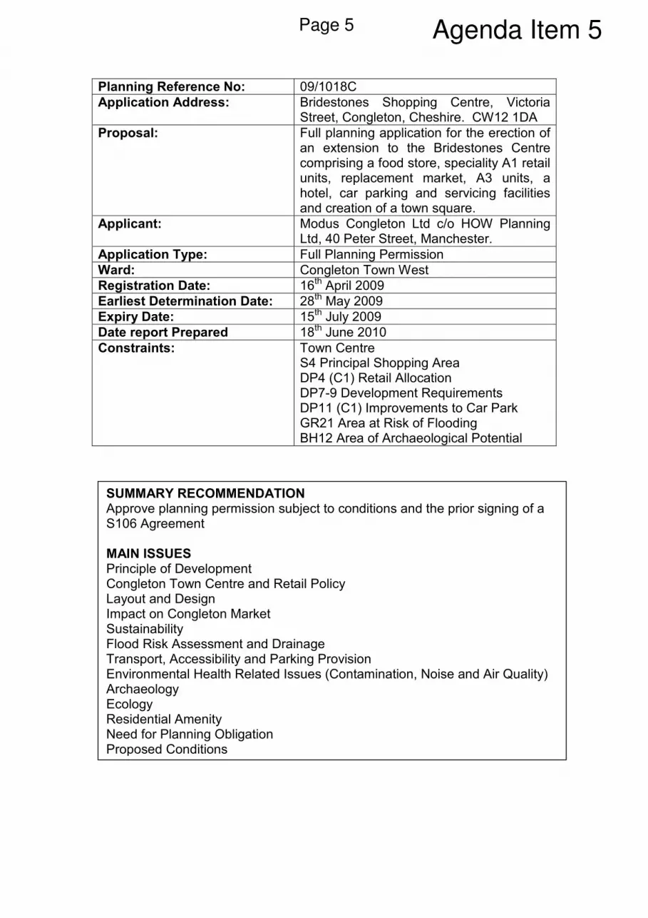
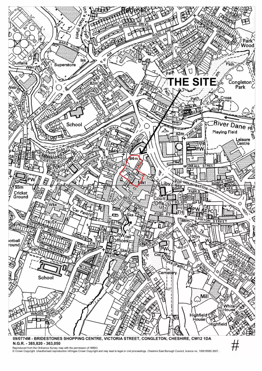
Planning Reference No: 09/1018C
Application Address: Bridestones Shopping Centre, Victoria Street, Congleton, Cheshire. CW12 1DA
Proposal: Full planning application for the erection of an extension to the Bridestones Centre comprising a food store, speciality A1 retail units, replacement market, A3 units, a hotel, car parking and servicing facilities and creation of a town square.
Applicant: Modus Congleton Ltd c/o HOW Planning Ltd, 40 Peter Street, Manchester.
Application Type: Full Planning Permission
Ward: Congleton Town West
Registration Date: 16th April 2009
Earliest Determination Date: 28th May 2009
Expiry Date: 15th July 2009
Date report Prepared 18th June 2010
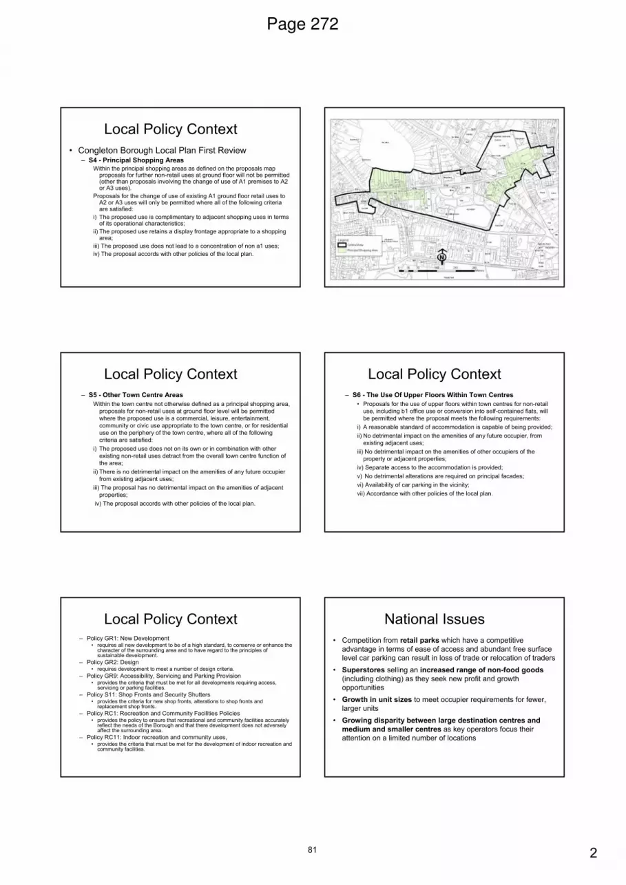
Constraints: Town Centre S4 Principal Shopping Area DP4 (C1) Retail Allocation DP7-9 Development Requirements DP11 (C1) Improvements to Car Park GR21 Area at Risk of Flooding BH12 Area of Archaeological Potential
SUMMARY RECOMMENDATION Approve planning permission subject to conditions and the prior signing of a S106 Agreement MAIN ISSUES Principle of Development Congleton Town Centre and Retail Policy Layout and Design Impact on Congleton Market Sustainability Flood Risk Assessment and Drainage Transport, Accessibility and Parking Provision Environmental Health Related Issues (Contamination, Noise and Air Quality) Archaeology Ecology Residential Amenity Need for Planning Obligation Proposed Conditions
Agenda Item 5Page 5
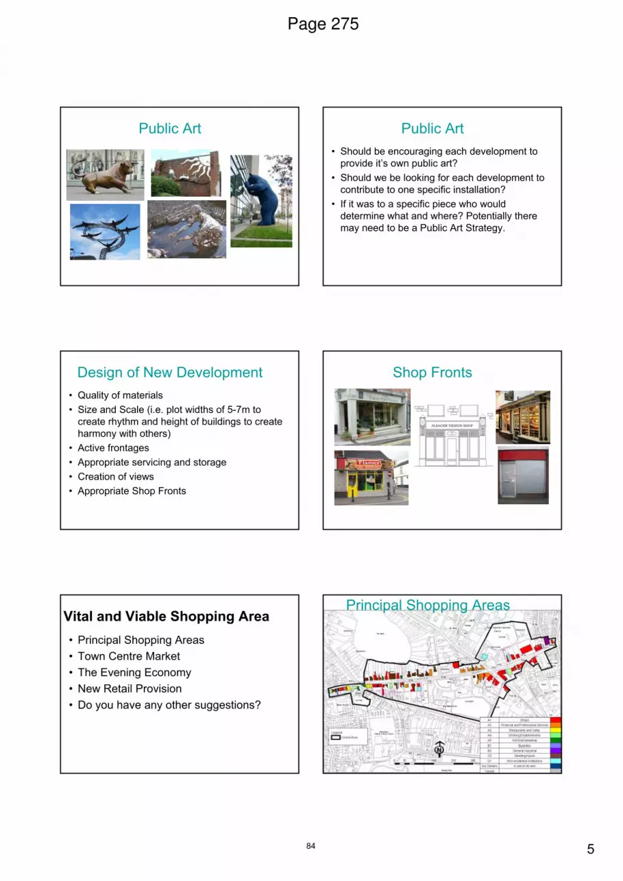
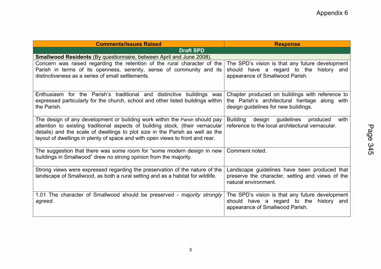
REASON FOR REPORT The application represents large-scale major development with retail and commercial floorspace in excess of the 9999m². The application also included submission of a Transport Assessment and would impact upon an Air Quality Management Area. DESCRIPTION OF SITE AND CONTEXT The application site comprises approximately 0.75ha of previously developed land located at the heart of Congleton Town Centre. Much of the site falls within the ‘Principal Shopping Area’ (PSA) and within an area dominated by retail and commercial uses. The application site itself reads as four discrete parcels comprising the 92-space Princess Street surface level public car park to the north; Congleton Market to the east which contains 11-lock up units and 85 permanent stalls; three retail units and a small parcel of vacant land to the west; and a group of commercial units within a central section fronting Princess Street which runs directly through the middle of the site. Whilst the site itself is generally flat, it is set within a natural hollow enclosed by higher ground to both the south (Bridge Street / Duke Street) and west where Mill Street winds its way down past the site before eventually meeting Mountbatten Way to the north. As a result, the buildings within the site which front Mill Street were constructed on raised platforms which are highly prominent when viewed from Stonehouse Green and the Princess Street car park. Similarly, the sites western boundary comprises a number of retaining structures, in some cases up to 7m in height, and a footpath (Stonehouse Green steps) that climbs up to meet Mill Street and Antrobus Street. The sites northern boundary directly adjoins Stonehouse Green, a relatively short stretch of highway which provides access to Princess Street car park and the Grade 2* listed Brook Mill, a derelict six storey brick mill which was recently extended with a series of four and five storey blocks constructed as part of a failed scheme to convert the mill for residential use. The sites eastern boundary directly abuts the walls of the existing Bridestone Centre’s multi-storey and basement car parks. In the far southeastern corner lies a staircase and ramp which provide direct access from this basement area, which contains Congleton Market, to a pedestrian concourse which runs around the upper section of the Bridestones centre from where access can be gained to shops including Morrisons, the multi-storey car park deck and Victoria Street which in turn connects into Bridge Street, Congleton’s main town centre shopping street. The sites southern boundary directly adjoins the Argos store within the existing Bridestone Centre where, on the stores western gable, levels drop vertically into a service yard area used, and enclosed, by commercial properties along Bridge Street, Duke Street and Mill Street.
Page 6
To the southwestern corner of the site lies no19 Mill Street, a two-storey split-level property which has been significantly extended over the course of time. The property contains T&S Electrical on the ground floor levels with two residential flats at upper floors levels. The gable of no19 contains two kitchen windows (one for each flat) that directly overlook the vacant parcel of land within the application site and a further low-level window which serves to ventilate a basement area used by T&S Electrical. The character the area immediately surrounding the site could be described as comprising four general typologies; firstly traditional two/three storey bay fronted shop design found in the High Street, Bridge Street and Duke Street; secondly three storey Georgian archetype comprising large, robust buildings with shallow pitched roofs and decorated central door features found in areas such as West Street, Lawton Street and Moody Street; the mill building archetype, such as Brook Mill, which are generally tall with large windows set in a strong vertical rhythm; and finally, 80’s development such as the original Bridestone Centre comprising monolithic units and an unsympathetic layout which significantly disrupted traditional street patterns within the town. Vehicular access into the site is gained directly off the A54 Mountbatten Way by means of a dedicated right turn lane into Stonehouse Green and subsequently Princess Street. Vehicles leaving the site are controlled by way of a priority junction with a left turn only out onto the A54 Mountbatten Way which, after a short distance, meets a roundabout at the junction of Mill Street, the A54 at Rood Hill. DETAILS OF PROPOSAL The application seeks permission for an extension to the Bridestone Centre in the form of a mixed-use, retail led scheme comprising a new A1 food store, A1 speciality retail units, 93 bed hotel, café and restaurant uses, town square, car parking and servicing areas. The amount of overall floorspace proposed would measure 12,283m² comprising 6098m² gross retail, 3830sqm for hotel use, 910m² for restaurants and cafe use with the remaining 1445m² being identified as ‘landlords area’ to be used for servicing and the like. In terms of scale, the scheme presents a mix of two, three and four storeys façades to public elevations but as part of an overall five-storey scheme when taking into account the split-levels across the site and the provision of basement parking at basement levels. The scheme however, and split of activities across the different floors, is described in more detail below. Proposed Car Park Level 1 At proposed car park level 1, where Congleton market and Princess Street car park are currently located, the scheme seeks to deliver a total of 111no basement car parking spaces split between two separate car park areas to either side of Princess Street. The eastern side would contain a 58 space car park, centre management suite, shop mobility facility, hotel service core and a dedicated market service with storage, service and refuse areas along with two heavy duty service lifts
Page 7
giving access to the next floor and proposed market square. Parking spaces within this area would be available for traders on market days and could, for the most part, accommodate all but the tallest of vans that would be restricted by virtue of the ceiling height. In this respect however, it would be possible for up to three vans to load within the proposed service lay-by incorporated within Princess Street with long-term parking available for up to 13 vans on a small section of Council owned land located off Stonehouse Green. To the western side, the applicants propose a 53-space car park with ramp to the next floor level and its additional car parking spaces. It would also contain the food store delivery area (1117m²), dedicated service yard service area and HGV turning area. Vehicular access would be maintained along the length of Princess Street however to the to the existing service yard area. Proposed Car Park Level 2 The western side of proposed car park level 2 would comprise a further 141-car parking spaces built on a deck erected over the car park and food store service area beneath. In terms of levels, the ceiling of this section would sit just above pavement level on Mill Street. The eastern side would contain the first major component of the scheme in the form of the proposed town square, capable of accommodating up to 36 outdoor market stalls, which would be enclosed by one speciality retail unit, the indoor market units and ground floor of a proposed café. This level would also contain traders’ amenities, toilets and a market manager’s office that would directly overlook the service area/lay-by on Princess Street below. The levels of this area having been designed to connect into Victoria Street and the upper parking deck and pedestrian concourse of the original Bridestone Centre. Proposed Food Store Level This level would contain the food store component on a single 4135m²-trading floor, which spans both Princess Street and the western car park deck, and an additional cafe. It would sit on an approximate level with Mill Street and one floor above the proposed town square to which it would connect by means of a staircase and elevators. The layout of this floor proposes to locate the food store entrance on the southern façade out onto a new pedestrian arcade which would be lined by the glazed food store frontage and five speciality units. This arcade would run east to west providing both pedestrian connections between the development and Mill Street and a visual axis towards the Town Halls landmark tower. Proposed Hotel Level 1 and 2 The scheme proposes a 93-bed hotel split over two floors in a U-shaped arrangement above the food store component. The hotel would also include a restaurant and bar area with a stair core on its northwestern corner providing emergency access down to Mill Street.
Page 8
Design In design terms, the scheme has been designed using two distinct styles. The first of these, to Mill Street, is influenced by the Georgian archetype. Here the traditional two-storey façade has been broken down with a series of staggers and punctuations so as to create what read as a series of smaller frontages akin to those within the historic town centre areas. The second approach however is entirely modern. Here a large continuous glazed façade runs the length of the pedestrian arcade and supermarket frontages before wrapping around into the new public square extending to encompass the indoor market and café frontages. The upper floors of the hotel comprising brick facades with interspersed with a regular pattern of fenestration aligned with the lager area of glazing in the food store below. In terms of other aspects of the scheme, a number off-site highway works are also required although these are discussed in detail throughout the report. RELEVANT HISTORY Where there are a number of historic applications across the development site, it is not considered they are relevant to determination of this application. POLICIES National Policy PPS1 ‘Delivering Sustainable Development’ and supporting documents PPS4 ‘Planning for Sustainable Economic Growth’ PPS5 ‘Planning for the Historic Environment’ PPS9 ‘Bio-diversity and Geological Conservation’ PPS10 ‘Planning for Sustainable Waste Management’ PPG13 ‘Transport’ PPS22 ‘Renewable Energy’ PPS23 ‘Planning and Pollution Control’ PPG24 ‘Planning and Noise’ PPS25 ‘Development and Flood Risk’ Regional Spatial Strategy DP1 ‘Spatial Principles’ DP2 ‘Promote Sustainable Communities’ DP3 ‘Promote Sustainable Economic Development’ DP4 ‘Make the Best Use of Existing Resources and Infrastructure’ DP5 ‘Manage Travel Demand; Reduce the Need to Travel, and increase accessibility’ DP6 ‘Marry Opportunity and Need’ DP7 ‘Promote Environmental Quality’ DP9 ‘Reduce Emissions and Adapt to Climate Change’ RDF1 ‘Spatial Priorities’ W1 ‘Strengthening the Regional Economy’ W5 ‘Retail Development’ W6 ‘Tourism and the Visitor Economy’ W7 ‘Principles for Tourism Development’ RT2 ‘Managing Travel Demand’
Page 9
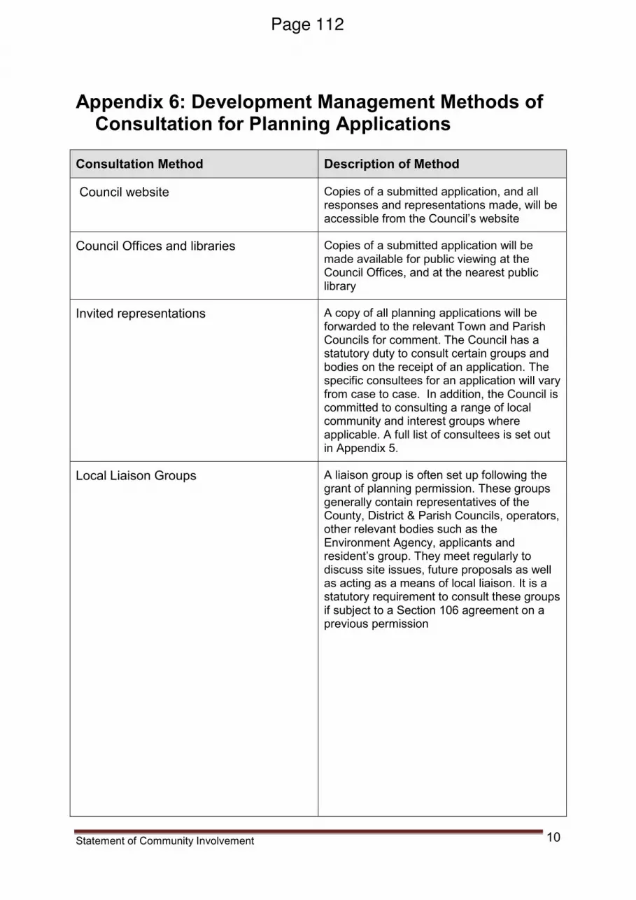
RT9 ‘Walking and Cycling’ EM1 ‘Integrated Enhancement and Protection of the Regions Environmental Assets’ EM2 ‘Remediation Contaminated Land’ EM3 Green Infrastructure’ EM5 ‘Integrated Water Management’ EM11 ‘Waste Management Principles’ EM16 ‘Energy Conservation and Efficiency’ EM18 ‘Decentralised Energy Supply’ MCR3 ‘Southern Part of the Manchester City Region’ MCR4 South Cheshire’ Local Plan Policy PS4 ‘Towns’ PS12 ‘Strategic Transport Corridors’ GR1 ‘New Development’ GR2 ‘Design GR4 ‘Landscaping’ GR6 ‘Amenity and Health’ GR7 ‘Amenity and Health’ GR9 ‘Accessibility, Servicing and Parking Provision’ GR10 ‘Accessibility, Servicing and Parking Provision’ GR14 ‘Cycling Measures’ GR15 ‘Pedestrian Measures’ GR17 ‘Car Parking’ GR18 ‘Traffic Measures’ GR19 ‘Infrastructure’ GR20 ‘Public Utilities’ GR21 ‘Flood Prevention’ GR22 ‘Open Space Provision’ NR1 ‘Trees and Woodlands’ NR2 ‘Statutory Sites’ NR3 ‘Habitats’ NR5 ‘Enhance Nature Conservation’ S1 ‘Shopping Hierarchy’ S4 ‘Principal Shopping Areas’ S5 ‘Other Town Centre Areas’ S6 ‘The Use of Upper Floors Within Town Centres’ S11 ‘Shop Fronts’ S12 ‘Security Shutters – Solid Lath’ S13 Security Shutters – Lattice /Mesh Grilles’ S16 ‘Environmental Improvements and Traffic Management Measures’ BH12 ‘Area of Archaeological Potential’ E16 ‘Tourism and Visitor Development’ ‘Facilities and Attractions’ E17 ‘Serviced Accommodation’ DP4 (C1) ‘Retail Allocation’ DP7 ‘Car Park Requirements’ DP8 ‘Supplementary Planning Guidance’ DP9 ‘Transport Assessment Required’ DP11 (C1) ‘Improvements to Car Park’
Page 10
SPD4 ‘Sustainable Development’ Other Material Considerations
• Development Brief for Congleton Princess Street Area 25th March 2009
• Volume 2: Cheshire Town Centre Study 2006 to 2021
• Report to Congleton Partnership on the Potential Relocation of Congleton Market by New Market Solutions (July 2008)
• Congleton Town Centre Plan (Final Report, March 2008)
• Congleton Renaissance ‘An Economic Development & Tourism Strategy for the Borough of Congleton’ 2007/2016.
• Congleton in Transition ‘A Regeneration and Development Strategy for the Town of Congleton’ 12th December 2008
• The Cheshire Replacement Waste Local Plan March 2010
• Manual For Streets
• Circular 11/95 ‘Planning Conditions’
• Circular 05/05 ‘Planning Obligations’
• Chief Planning Officer Letter from the SoS re abolition of RSS.
• Advice Produced by the Planning Inspectorate for Use by its Inspectors. Regional Strategies – Forthcoming Abolition
• The Town and Country Planning (Consultation) (England) Direction 2009 CONSIDERATIONS (External to Planning) Environment Agency: The Environment Agency confirmed it has no objection to the proposed development but advise that two conditions must be attached to any permission. The first of these relates to drainage and requires the applicants, prior to the commencement of development, to submit a scheme for the management of risk associated with flooding from surcharging of surface water drainage. The second relates to contamination and in this respect, whilst the Environment Agency do not consider the scheme to pose a significant risk to controlled water receptors, the presence of Howty Brook beneath the site means that should any evidence of contamination not already identified be found during the development of the site a detailed scheme for remediation must be submitted to the Local Planning Authority for approval. A list of informatives has also been provided covering requirements for written consents, waste exemptions, rainwater filtration and protection of watercourses during construction. United Utilities: Have no objection to the proposed development. They do however advise that the scheme must be drained on a separate system with only foul drainage connected into the foul sewer and surface water discharged to Howty Brook subject to approval of the Environment Agency. They also advise that a water main and public sewers cross the site and that no building will not be permitted over them with any necessary diversion being at the applicant’s expense.
Page 11
4NW: 4NW advise that the scheme, in broad terms, conforms with RSS DP and RDF policies. They consider that in economic terms the scheme raises no major issues and that that the uses proposed are consistent with RSS W5 and PPS6 (subsequently superseded by PPS4). They consider it generally complies with transport policies within RSS principally DP5 and RT2, provides a level of parking within the specified standards and also makes ample provision for cycle parking. 4NW then make a series of more generalised points on environmental issues and sustainable design with which should be incorporated into the scheme where possible. Archaeology Planning Advisory Service: The Development Control Archaeologist (DCA) concluded that based on the recommendations within the applicants assessment, three areas should be subject to a programme of evaluation trenching to establish the need, if any, for further archaeological mitigation, the DCA advised that the works should be carried out prior to determination and that any further work which subsequently proved necessary be secured by condition. Strategic Highways Manager: No objection to the proposed development subject to the imposition of conditions and inclusion of off-site highway works within a S106 Agreement. Environmental Health: Scientific Officer - Air Quality 29th May 2009 The Scientific Officers (SO) original response noted that the development would have an adverse impact on air quality at the Air Quality Management Area 4 (A34/A54 Junction) in terms of nitrogen dioxide emissions. The SO advised that further mitigation measures must be considered to ensure air quality at relevant receptors and within the Air Quality Management Area (AQMA) is not further affected by the development. In terms of site preparation and construction phase, the SO recommended that the proposed dust management plan is both implemented and agreed with the local authority prior to commencing works in order to minimise the impact on air quality and in order to ensure that dust related complaints are kept to a minimum during construction. The SO also recommended that the travel plan be linked into the air quality assessment but that further discussion on this matter should be held directly with the SO. 19th January 2010 The SO response advised that she had reviewed the amended air quality assessment but sought clarification on a number of points relating to modelling data, assessment methods and impact.
Page 12
7th May 2010 Following an assessment of a final supplementary note from the applicant’s consultant, the SO confirmed no objection to the proposal subject to: - 1) Scheme for dust mitigation included as part of a Construction Environmental Management Plan (CEMP) 2) Implementation of the identified Travel Plan 3) Implementation of proposed junction improvements at Rood Hill/Rood Lane to alleviate congestion and reduce emissions. (Because the scheme would have a significant predicted 1.3% increase in NOM emissions within the AQMA) Contaminated Land Observations No objection to the proposed development but advised that whilst contamination has no implications human health, the Environment Agency should be contacted for comments prior to works commencing on-site. It was also noted that some soils may not be aesthetically acceptable to remain on-site and would need be removed and disposed of in an appropriate manner and that further information would be needed in relation to gas monitoring before comments could be provided. Noise Assessment Observations No objection to the proposed development but noted that the standard of mitigation for the proposed hotel (a “reasonable standard” as described under World Health Organisation Guidelines and BS 8233:1999) would need to be upgraded to achieve a good standard (as prescribed within PPG24 and BS8233: 1999). It was also noted that detailed schemes for mitigation of noise from plant and equipment would be needed for each phase of development or installation which should be should be agreed with the Council prior to commencement of development on that particular phase. General Environmental Health Observations A number of other general observations were made in relation to control of noise during demolition and construction through use of conditions to control hours of operation. It will also be necessary to impose a condition to ensure details of the filtration and extraction equipment for the restaurant and café uses prior to installation. Cheshire Police: The Architectural Liaison Officer provided a detailed advice note in relation to the layout and design of the scheme that extended to cover a number of areas within the scheme including the car park, hotel, underpass and general public areas.
Page 13
Nature Conservation Officer: The Councils NCO initial response raised concern that insufficient information had been submitted in terms of the potential impact from the development on bats and that further survey work would be required by the applicants as recommended within their original bat survey. Following the submission of an additional survey and written confirmation that the scheme would avoid damage or disturbance of the culvert entrance the NCO subsequently confirmed however that he was satisfied that the proposed development would avoid unacceptable impact and that he had no objection to the proposed development. VIEWS OF CONGLETON TOWN COUNCIL A number of responses have been received from the Town Council over the course of the application which have been available to view in full on the website. However by way of summary the main representations covered the following areas: - 21st May 2009 Generally it was considered that the development should maximise use of pitched roofs, avoid flat roofs and incorporate extensive Greenery to provide attractive scenery. CTC recognised that the development will become the focal point for the town but they advise this must not be at the expense of other important areas of the town and the opportunity should be taken to join up Lawton Street and areas north of Mountbatten Way through inclusion of signing and pedestrian crossings. In relation to the Market, a number of concerns were discussed in relation to lack of indoor units, proposed temporary market location and lack of consultation with market traders. A number of other specific points were raised: -
• A lack of support for the proposed clock tower because they feel a different landmark would be appropriate.
• Questioning toilet provision and cycle parking provision.
• Requesting conditions on any permission to enhance the Bridestones Phase 1 gable wall.
• That whilst the development seems to make adequate provision for parking once completed, there will be a shortage during construction.
• Advising they would like to ensure dial-a-ride access can be gained into the new development.
• That the provision of a shop mobility service would considerably add to the user friendliness of the site.
• Concluding that they welcomed the opportunity to provide initial reaction but that there work has not yet finished.
Page 14
OTHER REPRESENTATIONS In total, 37 letters were received objecting to the development of which 28 were received during the first round of consultations with the remaining 9 received after the second consultation. The main concerns are summarised below:
• The changes to the town’s appearance and its character will be massive.
• The materials and the ultra modern design with lots of glass and flat roofs is not in keeping with the historic character of this town.
• The townscape of Congleton is one of pitched roofs and chimney pots not flat roofs.
• The main structure and the properties fronting Mill St are too tall.
• The market square will be ‘closed-in’ by the tall shopping centre.
• The narrow alleyways will compromise community safety.
• Proposed greenscaping of the public realm is unimaginative.
• Good quality public toilets need to be incorporated within the site.
• There is no need for a 100-bed hotel, more café’s/restaurants or another supermarket in the town? There is already enough competition.
• Demand for the units needs to be established before the scheme goes ahead.
• Congleton hasn’t the public or the tourist turnover capacity to sustain the development.
• This whole development will destroy local trade.
• The infrastructure required to support the increased number of visitors coming to the development has been underestimated.
• The proposals will add to traffic congestion in the Town.
• The proposed access arrangements and parking is inadequate and would exacerbate existing problems.
• A 100-bedroom hotel with 80% occupancy will require 75+ spaces from about 4pm onwards reducing the number of spaces. The lack of spaces will be compounded if the food store operates 24 hours.
• It is unclear what ‘parking management’ measures will consist of.
• Loss of light to adjacent windows in adjoining premises.
• Unable to maintain adjoining properties i.e. gutters, down pipes etc.
• Reduction in property values.
• Noise pollution.
• Disturbance to the way local businesses operate while the building works are being carried out. This may prevent/deter customers from accessing premises on Mill Street.
• The number of indoor market units should not be reduced.
• Such large proposals should be considered alongside the nearby Fairground site and other adjacent proposals, such as the town surgery and the halted developments on the Brooke Mill and Mill Green sites.
• If as stated within the plans Morrison’s is to move to the new premises, what is to happen to the old store?
• There is little or no detail as to what sustainability measures are to be employed.
• Do the developers have the financial capacity to complete such a project?
Page 15
• The location of the market and the hotel is totally speculative. A further detailed technical representation from Drivers Jonas Deloitte on behalf of the CWC Group. The main concerns can be summarised as follows: -
• That the proposal has not been robustly tested in terms of deliverability and viability and that the Council must be sure that the proposals will deliver long-term regeneration.
• That there is a need to update the retail evidence base before determination of the application and that the current CTCS is not valid given the introduction of PPS4.
• The proposal would harm the vitality and viability of the Town Centre shifting the retail core towards the rear of the Bridestones Centre.
• It would prejudice wider Town Centre regeneration.
• The Council must consider whether alternative proposals can deliver a more comprehensive approach to regeneration of the Town Centre before listing a series of benefits associated with their own proposals.
• That the proposed development requires a full PPS4 Impact Assessment on the basis that the current development plan is not up to date, the sites allocation is historic with emerging guidance likely to present a more accurate picture in terms of need.
• That the assessment must extend to include the effect on wider regeneration of the Town Centre.
• That the application, if recommended for approval, must be referred to the Government Office for the North West.
Additional concerns expressed by Market traders:
• The temporary market location is dismal and unappealing.
• There are only plans for 7 indoor market stalls when there are currently 11.
• Concerns regarding air conditioning, ventilation, hygiene, health and safety and sanitation, fire exits, fumes from the car park etc.
• There is insufficient space for market traders and the market café.
• The ceilings are too low to accommodate large equipment e.g. freezers.
• Vehicle access is greatly reduced for loading and unloading produce.
• No provision for vehicular access to the raised level where the market stalls are planned to go.
• Placing the markets on the upper floors and requiring them to use lifts to load and unload is unacceptable especially as the traders tend to arrive and leave at the same times.
• Lack of permanent protection from the weather with no provision for an indoor market hall.
The Congleton Chronicle also submitted a number of public comment sheets completed by those visiting an exhibition in their offices during the formal public consultation process. Your officers recommend however that little, or no weight be attached to these representations however because they appear
Page 16
to have been completed for use by the Congleton Chronicle as opposed to being formal representations to the Local Planning Authority. Town Centre Manager The Congleton Town Centre Manager has stressed that there is a need to redevelop this part of the town and considers that the proposals are a great improvement on the initial suggestions. The creation of ‘Market Square’, the effort to blend the development in with Mill Street, the proposed footpath widening and traffic management along Mill Street and the increased parking provision is much needed. However, there are a number of points that are raised and these are summarised below:
• Alternative parking provision should be made available for when the Princess car park is lost.
• If the PCT opt for the Fairground site, the 2 developments could be carried out at the same time and this could impact negatively on the town.
• The area needs to be kept as attractive as possible during the course of the development.
• There is real concern about the town retaining its status as a Market Town.
• The interim arrangements for the temporary market are not practical and do not reflect the recommendations made in the New Market Solutions Report.
• There is also concern about the move from an indoor market and a series of lock-ups, as these will not create the same synergy.
• The design and appearance of the lockups when they are closed needs to be considered.
• Have plans been made to accommodate Congleton Sunday Car Boot?
• The traffic counts carried out by Savill Bird and Axon suggest that the main route in for the Bridestones Centre is via Morrison’s car park. If the Stone House Green becomes the main route in and out for the hotel and a larger car park then improvements to the junction with Mountbatten Way and the associated traffic signals will be needed to prevent traffic backing up to the Aldi roundabout and the A34.
• The provision and maintenance of public toilets needs to be considered.
• Will provisions be made for additional CCTV particularly in the new square?
• Could the public realm be extended into the pedestrian area to improve linkages?
Congleton Partnership The Congleton Partnership has expressed concerns about the proposals. The mains points are summarised as follows:
• Connectivity – how the areas of the town outside the development will be affected and the impact on traffic flow and public safety on Mountbatten Way.
Page 17
• The market is a major part of the town’s character and as such the alternative arrangements must be deliverable and supportive of the requirements of members of the public and traders.
• There is concern regarding accessibility to the new square for traders, the emergency services and for public events.
• Only 10% of the development’s energy usage will come from renewable sources.
• More support needs to be given to improving the town’s public realm both in terms of a design brief and the provision of physical features.
Congleton Business Association: Congleton Business Association has offered the following comments:
• There are concerns that Congleton’s status as a Market Town could be lost by the interim plans for the market and the longer term plans for a smaller outdoor and indoor market.
• The arrival of a major superstore could lead to many independent retailers closing down and therefore changing the nature and the character of the town.
• Hotels in the area suffer from high occupancy rates and many have gone into administration.
• The development could disrupt the River Dane Wildlife Corridor.
• Princess Street car park should remain open as long as possible with replacement and workforce parking provided.
• Links and clear routes with other retail areas should be created.
• The area should be kept as attractive as possible during the works. APLLICANT'S SUPPORTING INFORMATION Documents submitted 3rd April 2009 Supporting Planning and Retail Statement (April 2009) Design and Access Statement (April 2009) External Landscape Plan (February 2009) Transport Assessment (Apr 09) Market Strategy Note (March 2009) Noise Impact Assessment (April 2009) Air Quality Assessment (April 2009) Ecological Walk-over Survey (April 2008) & Bat Survey Report (Nov 2008) Air Quality Assessment (April 2009) Environmental Noise Assessment (April 2009) Site investigation Report (February 2008) Flood Risk Assessment and Surface Water Survey (February 2009) Sustainability Report (March 2009) Archaeological Survey (April 2009) Waste Management Plan Further Round of Documents Submitted 18th November 2009 Retail Addendum Report (October 2009) Revised Transport Assessment (November 2009)
Page 18
Revised Market Strategy Note (November 2009) Additional Bat Survey Report (August 2009) Revised Market Strategy Note (12th November 2009) Revised Air Quality Assessment (24th December 2009) Revised Noise Assessment (24th December 2009) Further Submissions PPS4 Supplementary Retail Statement (10th February 2010) Air Quality Assessment Supplementary Letter (30th March 2010) Drawings 0-101 Rev * Proposed New Food Store and Hotel Site Plan 1-101 Rev B Proposed New Food Store & Hotel Plan at Princess St Level 1 1-102 Rev A Proposed New Food Store & Hotel Plan at Car Park Level 2 1-103 Rev C Proposed New Food Store & Hotel Plan Food Store Level 1-104 Rev B Proposed New Food Store & Hotel Plan at Hotel Level 1 1-105 Rev B Proposed New Food Store & Hotel Plan at Hotel Level 2 2-101 Rev B Proposed New Food Store and Hotel Sections A-A and L-L 2-102 Rev A Proposed New Food Store and Hotel Sections B-B and C-C 2-103 Rev A Proposed New Food Store and Hotel Sections M-M and F-F 2-104 Rev - Proposed New Food Store and Hotel Sections O-O 2-105 Rev B Proposed New Food Store and Hotel Sections H-H and K-K 3-101 Rev C Proposed New Food Store and Hotel Elevations J-J and N-N OFFICER APPRAISAL Principle of Development The principle of retail development on the application site is established by local plan policy allocation DP4 (C1) that identified the site as being suitable for improvement and development for retail uses. A significant percentage of the application site and site allocation also falls within the identified principal shopping area (PSA) where retail development is generally concentrated and in this respect, the proposal is considered to reinforce the town’s retail core, although this is discussed in more detail within the next section of the report. Similarly, whilst only an informal policy document of limited weight, the Congleton Town Centre Plan identifies the site as a ‘Primary Development Site’ of high importance being suitable for a large retail floorplate to include a modern town centre supermarket for large/medium sized retail uses with additional restaurant and café uses to encourage the night time economy. The inclusion of the additional hotel, café and restaurants uses as part of the overall development mix is also entirely consistent main town uses identified within PPS4 and RSS policies W5 and W7. PPS4 recognises that such uses play an important role in meeting the main objectives to deliver prosperous economies by focusing new economic growth within existing centres and by offering a wide range of services to communities, promoting competition
Page 19
between retailers and enhanced consumer choice through the provision of innovative and efficient shopping, leisure, tourism and local services within town centres. Similarly the RSS seeks to promote retail investment where it assists in regeneration and economic growth (policy W5) and seeks to develop tourism within the region more generally (policy W7). The proposals would also deliver high quality, sustainable economic development within the heart of Congleton Town Centre utilising a highly accessible and previously developed site and on that basis your officers consider the scheme performs well against the general policy aims of PPS1, PPS4 and RSS in particular. Retail Impact, Assessment and Related Issues In dealing with this application, Members will be aware that the application has been with the Council for some time. It is therefore important to clarify that documents submitted with the application, which assessed the development against PPS6, are no longer relevant to the determination of the application and that it is now PPS4 that sets the policy framework against which the application must be assessed. At EC10.1, PPS4 advises Local Planning Authorities to adopt a positive and constructive approach towards applications for economic development and treat favourably, applications which secure sustainable economic growth. Therefore, given that your officers consider the scheme successfully delivers sustainable economic development, it is recommended Members treat the application favourably. Members must also give significant weight to the fact that the site is allocated for retail development within the adopted Local Plan. In addition to the above however, EC10.2 of PPS4 also requires proposals for economic development to be assessed against five impact considerations. In terms of EC10.2 (A), your officers consider that the indicative details provided demonstrate that the scheme would perform satisfactorily being capable of generating 10% of its renewable energy from a variety of sources (subject to a final tenants specifications) and can adequately cope with climate change subject to the final approval of detailed surface water regulation strategy by the Environment Agency. In relation to EC10.2 (B) the site performs extremely well. It is located at the heart of Congleton Town Centre, is accessible by a range of transport and is predicted to encourage more linked trips into the town centre thereby reducing the need to travel. The impact of the development on the local highway network in terms of traffic levels and congestion is also considered to be acceptable subject to a number of off-site highway works. For reasons discussed in depth within the next section (Layout and Design), it is considered the impacts identified under EC10.2 (C) would be wholly positive. For example, the scheme will enhance the character of the area and the way it functions by introducing the new retail circuit, creating an attractive built frontage to Mill Street and delivering a new town square and market site.
Page 20
Similarly, the impacts resulting from the development in terms of EC10.2 (D)& EC10.2 (E) are considered to be positive in overall terms. The scheme will deliver regeneration of an allocated site at the heart of the town centre which will serve to largely strengthen the town centre and deliver new job opportunities within the proposed hotel and food store in particular. Your officers therefore consider that the development will have significant positive impact when assessed against EC10.2 demonstrating that the scheme will deliver sustainable economic development (EC10.1). In addition to EC10 however, PPS4 EC14 also requires the local planning authority to consider whether a sequential test (EC15) and Impact Test (EC16) are required for the development and these are now considered in more detail below. Sequential Test In the case of EC14.3, your officers are satisfied that the applicants do not have to undertake the sequential test because the site is located within a centre and the proposals are in accordance with an up to date development plan. In any case, your officers consider this to be the most sequentially preferable site capable given the percentage of the site within the PSA and its position directly adjacent to Bridge Street and Duke Street. Impact Test Your officers are also satisfied that an impact test is not required under EC14 despite the applicants PPS4 addendum submission on 10th February 2010. This is because EC14.6 advises impact tests are only required where an application relates to a site within an existing centre not in accordance with an up to date development plan and which would substantially increase the attraction of a centre to the extent that the development could have an impact on other centres. In this case the site is allocated within the adopted Local Plan under policy DP4 for retail development and is thus excluded from the provisions of EC14.6. Whilst a small part of the site clearly falls outside the DP4 allocation, this is unallocated land with which there is no policy conflict and is not considered to undermine the objectives of EC14.6. Whilst EC16.1 (E) sets a further threshold for submission of an impact test in relation to scale, your officers again consider this would be unnecessary having regard to advice within the PPS4 Practice Note. Firstly, the net retail floorspace proposed within the scheme accords with the site allocation which indicates that the site could accommodate approximately 4000m² net retail floorspace. Secondly, the Town would still fit the PPS4 ‘District Centre’ typology in which it would fall. Thirdly, in terms of the guidance notes reference to evidence of need, the delivery of 2480m² net convenience would sit within the town’s long-term need to 2021 for 2650m². There are also a number of other matters that require consideration and these are now discussed in more detail below.
Page 21
Whether the scheme is ‘Deliverable’ and has been robustly tested. A detailed objection was submitted on behalf of CWC who argued that deliverability of the scheme has not been robustly tested. Here PPS4 advises that deliverability should be assessed by consideration of the sites Availability, Suitability and Viability and I now turn to consider these in more detail. In terms of availability, the site is clearly available within the short term for redevelopment and is the site is clearly suitable for development having particular regard its site retail allocation and position within the Town Centre. In viability terms, whilst your officers acknowledge the general economic downturn, they consider the retail sector to be in a stronger position evidenced by recent developments within the Borough. Concerns over the proposed development in retail terms Concerns were also raised by CWC that the proposal falls outside the PSA and will shift the retail core to the back of the Bridestones Centre. In this respect, whilst the retail allocation clearly extends beyond the PSA, the decision to define the allocation would have been robustly assessed at the time of adoption and been subject to examination in public. Similarly, your officers do not accept CWC’s concerns over a possible ‘shift in the retail core’. The development clearly focuses activity within the proposed town square that would be located within the PSA and would result in a layout that serves to facilitate a new retail circuit within the town, something which is presently lacking. It is therefore considered that CWC’s concerns in this respect should be afforded no weight in the determination of the application Concerns over competition (Café & Restaurant Uses) Whilst officers can appreciate traders concerns over increased competition, CON.13 of the CTCS notes that Congleton has a below average provision of cafes and restaurants within the town centre. Your officers do not therefore consider this is a matter to be afforded weight in determination. Referral to the Secretary of State Whilst the objection from CWC also argues that the scheme must be referred to the Secretary of State (SoS) should Members resolve to grant permission, we disagree with this supposition because the proposed development clearly accords with the provisions of the development plan and does not therefore meet all of the necessary test by which development must be referred. Whilst it has been previously acknowledged that a small section falls outside any allocation, there is clearly no conflict or departure to indicate the scheme “does not accord with the provisions of the development plan in force”. Layout and Design The design and layout of the proposed development has evolved from public consultation and extensive pre-application discussions with the case officer and urban designer. Layout In respect to the layout, which in the case of this site is one of the most crucial elements to the success of the development and restoration of the town
Page 22
connectivity, the scheme successfully implements the design guidance contained within the Development Brief and Informal Town Centre Plan. In terms of pedestrian movement and townscape connectivity, the proposed layout successfully links the development into the town centre for a number of reasons now discussed in more detail. Firstly the proposed town square and market sit on a level with the existing Bridestones Centre and, crucially, Victoria Street serving to link the proposed development with Bridge Street, the town centre main shopping street. Secondly, the layout proposes creation of a new pedestrian arcade to connect the market and town square with Mill Street (and also Cross Street) thereby allowing shoppers and pedestrians to link back to Duke Street and Bridge Street facilitating creation of a new retail circuit within the town centre; something which is currently lacking and likely to have been a contributory factor in the town centres recent decline. Thirdly, and crucial to the success of the retail circuit, the layout secures a large number of different uses along the length of the route. At town square level, this includes Congleton Market, a small café and speciality retail unit reinforced by units within the existing Bridestone Centre. Similarly, the pedestrian arcade level would be anchored by the food stores entrance which is likely to be a significant generator of pedestrian footfall, and lined with a row of smaller speciality retail units. Fourthly this mixture of shops and restaurant, arranged in the manner proposed, will help to facilitate appropriate levels of activity through large parts of the day and night ensuring that the public square and pedestrian arcade remain vibrant active places which are well overlooked at all points The proposed town square will also act as a focal point for civic events, such as the Christmas lights switch on, and in this respect your officers will ensure that conditions and the S106 agreement allow for appropriate use of the square for public events, appropriate infrastructure is built into the scheme from day one and that the proposed surface materials positively contribute to the townscape character. In terms of Mill Street, the positioning of the food store element would allow for a continuous façade to be constructed along the entire length of the site frontage which would serve to complete the street in both built and visual terms but which also serves to introduce life and activity into what is an otherwise largely dead frontage. The layout has also successfully incorporated parking and service areas into the scheme beneath the development and, for the most part, out of the public realm. Whilst this has led to a sizeable underground parking and service area with resultant implications for crime and safety, a number of uses have been included at basement, notably centre management suite, shop mobility and market servicing area to ensure a reasonable degree of day-to-day activity
Page 23
and passive surveillance of these areas. Moreover the level of vehicle and pedestrian activity within these area is likely to be significant whilst safety can be bolstered still further with carefully designed schemes for lighting and CCTV; details which can be secured by way of conditions on any permission. Design Whilst representations have been received objecting to the design of the proposed development, your officers consider that it strikes an appropriate and sympathetic balance between traditional and contemporary design which is appropriate to the townscape of Congleton. The Mill Street façade adopts a largely traditional approach, influenced by the Georgian vernacular, arranged in a manner which replicates the scale and rhythm of buildings found in the town centre. This has the effect of breaking down an otherwise single continuous, potentially over-dominant, façade into a series of smaller ‘shop fronts’ which respects Mill Street and the character of the wider townscape but wit the inclusion of a contemporary glazed tower to acknowledge that this is a new chapter in Congleton’s history. On internal facades however, overlooking the proposed square and pedestrian arcade, a marked shift occurs in the design. Here a contemporary approach is adopted using curtain wall systems to introduce largely glazed elevations to the public realm. In this respect, your officers consider this approach to be entirely appropriate because it allows the introduction of contemporary design into the town centre in a sensitive manner bringing the vibrancy and activity inside buildings out into the public realm and whilst ensuring good levels of passive surveillance over the public realm. At an upper floor level, where views of the development would be seen from higher vantage points, the design reverts back to back to a more traditional façade with brick elevations and a more regular window pattern. However, the design does incorporate a contemporary clock tower which would act as the signature for the development once completed although the exact final design of this town however, including materials to be used, will need to be secured by way of condition. As a result, your officers consider that the design and layout of the scheme delivers high quality development in accordance with the requirements of PPS1, RSS policy DP1, DP2 and DP7, local plan policies GR1 and GR2 and the Princess Street Development Brief delivering in particular sustainable development which takes the opportunity to improve the character of the area and the way it functions. Impact on Congleton Market As part of the site’s redevelopment it is proposed to demolish Congleton’s existing permanent brick built market that comprises 11 lock-up units and 85 stalls and relocate it to the proposed town square through the provision of 11-indoor units and 36 pop-up outdoor stalls which can be erected on market days and be removed on the remaining days allowing the square to be used for other events and public activity.
Page 24
In its current location, the New Market Solutions (NMS) study, undertaken on behalf of Congleton Town Council, the then Congleton Borough Council and Modus to consider the implications of any redevelopment on Congleton’s market, advised that Congleton’s traditional two-day market is struggling partly because of its concealed location in a “basement” position, partly because of its type of build and lack of character and partly because competition in retailing is now so intense that small traders are being ‘squeezed out’ by big retail businesses. It went on to state that despite its position, nominally central to the retailing core of the town centre, the market is struggling and lacks the pedestrian flow that it needs to support its traders to maintain its vitality and viability and that without that vitality, its role in supporting the and partnering the town centre retail offer is very limited. Following the first round of public consultation on these proposals it became apparent that market traders and management team were particularly concerned about the proposed development. In this respect, whilst a large number of issues were raised by traders, and to a lesser degree the market management team, your officers consider the main concerns can be summarised as follows. Firstly, traders consider the proposed location for the temporary market within a basement unit underneath the existing Bridestone Centre to be entirely unsatisfactory in terms of its size, ceiling height, overall location (away from passing trade and in the centre of a building site), the general environment within the unit and because it lacked a service lift. Secondly, traders consider that the servicing arrangements for the new market were, and still are, entirely unacceptable. Here traders were, and still are, opposed to having to use a lift(s) to service their stalls and argue that they need direct access onto the square for their vehicles for loading and unloading as well as having access to their stock during trading hours. They also argued that the provision of only one lift within the initial layout and design scheme would be insufficient to accommodate the number of traders. Thirdly, that there were insufficient outdoor pitches and that only 7 indoor units were being provided when there were 11 ‘indoor traders’ operating. And finally that the layout of the proposed replacement market would fail to maximise the flow of shoppers around the stalls with some traders being left ‘isolated’ with little passing trade and that the use of pop-up stalls rather than something more substantial and weather proof. We now move on to consider these, and other market related issues, in more detail. New Market Location In terms of the location for the replacement market, your officers and market management team are entirely supportive of its position within the new town square and consider it to offer significant benefits. It lifts the market from its
Page 25
current isolated position beneath the Bridestones Centre into the heart of the new town square where it will be surrounded by other retail units and cafes and where it will benefit from significantly higher levels of footfall along the new retail circuit. Moreover, the location is entirely consistent with that recommended within the NMS Study which concluded that such a position is “by far the best means of ensuring that Congleton Market has a sustainable future” a recommendation with which your officers wholeheartedly agree. Operational Matters Moving on to consider operational aspects of the market, your officers considered at great length the traders concerns identified during the first round of consultation. Following a number of meetings between the case officer, market management team and the applicants architect it was agreed that a number of revision would be made to the design and layout of the scheme to address the market manager and trader concerns. As a result, and in terms of the market, the revised plans secured the following changes: -
• An increase from 7 single indoor units to 11 mixed size indoor units set around a public walkway with four egress points out to the town square.
• Made provision for an additional service lift solely for market traders
• An increase in the number of outdoor pitches to 36no in a revised layout based on advice from the market manager at City Markets;
• Revised parking and servicing arrangements for traders including additional loading spaces at basement level and confirmation of van parking (for smaller vans) at basement level; and finally
• Provision of trader facilities at market square level including traders amenity area, storage area, toilet as well as a market managers office which directly overlooks the shared service vehicle bay beneath.
Following submission of the revised plans your officers consider the latest layout and design caters far more appropriately for the requirements of the traders and market management team in terms of both servicing and day-to-day operational aspects. Whilst traders and the National Market Federation are still very concerned over the proposed servicing arrangements, both your officers and the Councils Market Management team are confident that the revised arrangements presents a workable solution. It would also be considered to be wholly undesirable to allow traders vehicles onto the town square having regard to pedestrian safety and the general damage which would undoubtedly occur to high quality surface materials as a result of oil, diesel and tyre stains. In overall terms therefore, acknowledging that some day-to-day management of operational aspects would be required, it is considered that with appropriate
Page 26
measures in place the market would function perfectly acceptably. Whilst your officers are therefore entirely satisfied with this position, the applicants have advised that they have recently secured an agreement with the owner of the adjacent Bridestone Centre to allow traders to use the upper deck of the existing multi-storey car park which is on the same level as the proposed town square and would allow for loading and un-loading of traders vehicles in close proximity to market stalls. Whilst it has not been possible to consult traders on this latest position, it is likely to go some way to address their concerns even though it is recommended a condition be attached to any permission to secure a scheme for implementation of physical barriers to prevent direct access onto the square. Temporary Market Location Whilst the matter of the temporary market is being considered under co-joined application 09/4176, also on the agenda, your officers share the concerns of the traders over the proposed basement location and consider that a temporary market on the Fairground site to be a far more appropriate option. Taking into account all of the above however, your officers consider that the Congleton Market will benefit significantly from the proposed development and that the scheme is entirely compliant with the requirements of PPS4, Princess Street Development Brief and recommendations contained within the NMS Market Study. Sustainability In overall terms the scheme is considered to have good sustainability credentials. It would make efficient use of a previously developed site within the town centre location and would therefore rank highest under RSS policy DP4. It has good links into the public transport network, further enhanced by the proposed off-site highway works to Mill Street, and includes provision for cycle parking and facilities for the disabled including shop mobility facilities. The scheme would also significantly enhance pedestrian connectivity and is likely to generate an increased number of linked trips which will contribute to the delivery of sustainable economic development in line with the requirements of PPS4. Similarly the development will also be required to meet RSS policy EM18 requirements to deliver 10% of the on-site energy demand (OED) from decentralised or renewable sources. At this stage, given the speculative nature of the scheme, the precise method by which the 10% will be achieved cannot be precisely identified. However the applicant’s Sustainability Report indicates the most financially viable options, and those likely to be incorporated would be a small-scale centralised CHP plant (3.11% of OED), and Biomass boilers (5.5% of OED) and with the possibility of solar thermal roof mounted cylinders (0.63% of OED) if grant funding could be achieved. The applicant’s sustainability report also advocates inclusion of power voltage optimisation to secure a 4.32% of saving of OED, however this method cannot count toward the 10% requirement although it serves to demonstrate significant reductions in energy use can be also achieved by other means for a small capital cost. Whilst further work is therefore needed on the part if the
Page 27
applicants, your officers consider that a condition can be attached to secure precise details as to how the 10% requirement will be met and to also secure inclusion of the proposed Green Roof and power voltage optimisation system. Conditions would also need to extend to include further information in relation to the proposed site waste management plan in order to comply with the Cheshire Waste Replacement Local Plan Policy Note 10 and 11. In this respect opportunities for potentially recycling waste materials into aggregate do not appear to have been considered by the report with further details of recycling of commercial waste also needed once an end occupier has been identified. Flood Risk Assessment (FRA) and Drainage Whilst the site is located within Flood Zone 2 of the Environment Agency indicative maps, an area identified at risk of flooding under Local Plan allocation GR21 and would also require the diversion of the culverted Howty Brook, the Environment Agency (EA) are satisfied that the proposed development is acceptable in terms of PPS25. In this respect, whilst the proposed mix of uses are considered to be ‘less vulnerable’ and appropriate for the site under PPS25, with the applicants FRA also showing that the diverted Howty could cope with a 1 in 100 year flood (with allowance for climate change) the sites surface water drainage system is at risk of flooding from what PPS25 terms as ‘event exceedance’. This would occur during periods of severe rainfall where the surface water drainage strategy could become surcharged out of the drains leading to overland flow that could cause a flooding problem. The EA therefore considers that a condition is necessary to ensure that no development commences until a scheme to manage flood risk from surcharging has been approved by the Council and which is then fully implemented and maintained in accordance with details to also be agreed. Therefore, subject to the imposition of the requested conditions, it is considered that the scheme would meet the requirements of PPS25 and policy GR21 of the adopted Local Plan. Transport, Accessibility and Parking Provision Proposed Vehicle Movements Following submission of a revised Transport Assessment (TA), the Strategic Highways and Transportation Manager (SHM) was satisfied that the vehicle movements generated by the proposed development could be safely accommodated within the existing highway network. In this regard, the TA assessed the impact on three existing junctions within Congleton at Stonehouse Green/A54 Mountbatten Way, the Mill Street/Mountbatten Way/Aldi roundabout and finally the signal controlled junction at Mountbatten Way, Market Street/Worrall Street.
Page 28
In all cases it was demonstrated that the increased traffic flows associated with the proposed development would not adversely affect the operational capacity of the critical junctions assessed within the TA. Whilst the TA identified that the exit from Stonehouse Green onto the A54 would operate close to its operational capacity during Saturday peak, this would still be within its operation capacity and the SHM was comfortable that this would not be an impediment to the redevelopment of the site. Moreover, in the case of the signal controlled junction to Mountbatten Way/Market Street/Worrall street, it was demonstrated that the junction could actually operate slightly better because existing Morrisons car park trips are likely to be re-assigned to the new food store resulting in fewer trips travelling through the junction. The TA also serves to demonstrate that HGV vehicle movements associated with the development can be satisfactorily accommodated through the provision of dedicated service areas for the retail, hotel and market elements. In overall terms therefore, the SHM agrees with the applicant’s conclusion that the increased vehicle flows resulting from the development can be safely accommodated on the local highway network and on that basis the proposed development is considered to be comply with the requirements of policies GR1, GR9 and GR18 of the adopted Local Plan. Accessibility Similarly, for reasons identified throughout the course of the report, the site is considered to benefit from good accessibility by a range of transport modes and performs well when assessed PPS1, PPG13, RSS and Local Plan policies. The SHM will however require a number of off-site highway works to be implemented to mitigate the negative impacts of the development in terms of air quality, further enhance pedestrian accessibility to the pubic transport network and ensure appropriate levels of pedestrian safety to the proposed retail circuit along Mill Street. These have therefore been included within the proposed heads of terms identified in the relevant forthcoming section. Car Parking Provision In terms of car parking provision your officers are satisfied that 252 car parking spaces is sufficient to meet the needs of the proposed development. Whilst the SHM expressed some initial concern at this figure, given it was below the maximum RSS standard of 420 spaces (328 for the food store element and 92 for the hotel), he is now satisfied that the provision of 252 spaces is sufficient to meet the needs of the development. The SHM reached this view due to fact that, amongst other things, the revised TA successfully demonstrated that the application site benefits from good level of accessibility by a range of transport modes and because the proposed mix of uses has complimentary peak periods (i.e. different peak parking times between the hotel and food store elements) which served to demonstrate that the 252 would be sufficient to meet the demands of the development. Furthermore the SHM recognised that the higher figure was a maximum
Page 29
figure, a view supported by 4NW who confirmed that car parking provision was within appropriate standards. Your officers are therefore satisfied that the proposed development accords with the parking standards within RSS, meets the requirements of Local Plan policy DP11 and satisfies the requirements of test EC18 within PPS4 offering a level of parking proportionate to the size of the centre. In respect of ensuring that the propose car parking serves the Town Centre as a whole, it is recommended that a condition be attached to any permission to ensure a minimum of 2-hours free parking on the site which would ensure linked trips could be made into the wider PSA. Notwithstanding the above however, it is important for Members to note that the closure of the Princess Street Car Park (coupled wit the loss of spaces on the Fairground site) is likely to result in a shortage of parking spaces within the Town Centre during the redevelopment of the site. Whilst this situation is unavoidable if the regeneration of the site is to be secured, discussions have been held with the Head of Car Parks who has confirmed he does not wish to object to the development and his service will act to address the matter should Members resolve to grant permission. Whilst it may be possible to mitigate some of the short-term harm by ensuring replacement car parking was delivered at the earliest possible stage (through the proposed phasing mechanism within the S106) this would be entirely dependant upon the proposed construction methods and site safety and would therefore require further discussions with the applicants. Environmental Health Related Issues Air Quality The revised Air Quality Assessment (AQA) and supplementary technical data indicate that the proposed development will impact upon air quality as a result of dust from construction and as a result of additional vehicular movements within the Air Quality Management Area 4 at the A34/A54 Rood Hill (AQMA). Traffic
In terms of the impact from additional vehicle movements, the applicant’s results show that predicted concentrations of Nitrogen Dioxide (NOM) at the junction of the A34/A54 will increase by +1.3% which they do not consider to be significant based on National Society for Clean Air guidance which advises increases of 1–5 % are deemed very small and thus only slightly adverse. Whilst Environmental Health disagrees with this conclusion, because any increase within the AQMA is significant, they advise that the impact can be appropriately mitigated in two ways. Firstly, through the proposed replacement of the existing antiquated signal controller at the A34/A54 Junction which would serve to improve traffic flows and reduce NOM emissions and secondly through implementation of a Travel Plan Framework to encourage more sustainable behaviour. Construction
Page 30
Similarly, whilst the proposed development has the potential to result in dust emissions during demolition and construction, any detrimental impact can be mitigated through measures to control dust during these times. Precise details by which this will be achieved can be secured by way of condition for submission of a Construction Environmental Management Plan (CEMP). Your officers are therefore satisfied that, subject to these measures being secured within a S106 Agreement, the proposed development would avoid any conflict with local plan policies GR1, GR6, GR7 and GR8. Contamination The applicants submitted detailed Phase 1 (desk top) and 2 (Intrusive Investigation) Assessments which concluded the risk to site users from contamination was low and, in the case of surface or culverted water features, to be low/ medium. On the basis of the findings within the applicant’s assessment therefore both Environmental Health and Environment Agency have confirmed they have no objection to the redevelopment of the site in the manner proposed. It will however be necessary to attach a number of conditions to any planning permission. The first of these relates ground gas because initial measured levels indicated some form of protection would be required. In this respect, it is likely further gas monitoring work will be required before a detailed scheme for gas protection measures is submitted and approved by the Authority ahead of development commencing. Secondly, in terms of the Environment Agency, a condition will be required to ensure that should any evidence of previously unidentified contamination be found during development of the site then development shall cease until such time as a detailed scheme for remediation has been submitted to the Local Planning Authority for approval. Subject to the imposition of these conditions however, your officers are satisfied that the scheme adequately addresses the requirements of PPS23 ‘Planning and Pollution Control’ and local plan policies GR1, GR6, GR7 and GR8. Noise It is not considered that noise presents any form of impediment to the redevelopment of the site. Whilst it will be necessary to incorporate some degree of mitigation into hotel bedrooms onto the northern (towards Mountbatten Way) and western facades (Mill Street), this will simply necessitate appropriate glazing and ventilation to ensure noise levels within hotel bedrooms achieves the “good standard” as prescribed within PPG24 and BS8233: 1999 which can be secured by way of condition. Similarly, whilst the development will include installation of plant and equipment, particularly to upper floor areas such as air conditioning, Environmental Health advise that scheme to mitigate such noise from such equipment in accordance with BS4142 can be agreed by way of condition to cover each
Page 31
phase of development and once more detail is known about the end user requirements and the particular specification of any equipment. Archaeology A large part of the Town Centre, including land within the application site, is identified as an area of archaeological potential and the applicants wee therefore required to submit a detailed desk based assessment to consider the impact of the proposed development. The applicant’s study identified three potential sites for further investigation. Site 1 was identified as possibly containing the remains of the wheelhouse, engine house and boiler houses of Stonehouse Green Mill and was also recommended for further sampling in relation to evidence of earlier land uses and possible deposits from Howty Brook. Site 2, an area adjacent to Mill Street and built upon in the late 18th century was identified as having potential for post-medieval and possibly medieval development. Comments in relation to site 3 were more general indicating that there is a possibility of the survival of some deposits probably relating to agricultural or horticultural use and possible early industry such as iron smelting. Following assessment of this document, the Development Control Archaeologist (DCA) noted the identification of these and recommended that they should be subject to a programme of evaluation trenching to establish the need, if any, for further archaeological mitigation. At the time, the DCA advised the works should be carried out prior to determination and that any further work, which proved necessary, be secured by condition. However, due to land ownership constraints, and the fact that two of the in question were in car parking and market use the applicants were unable to undertake the further sampling work requested suggested by the DCA. On that basis, and whilst the DCA would have preferred further trenching work to be undertaken prior to determination to establish whether further archaeological mitigation was required, your officers consider that the work undertaken to date is sufficient to meet the requirements of policy HE6.1 of PPS5 and that any further work can be secured by way of condition. Your officers reach this view because the desktop study presents a clear picture of the likely archaeological interests and confirms they are only likely to comprise items of local or regional significance only. Ecology Article 12 (1) of the EC Habitats Directive requires Member states to take requisite measures to establish a system of strict protection of certain animal species prohibiting the deterioration or destruction of breeding sites and resting places. Art. 16 of the Directive provides that if there is no satisfactory alternative and the derogation is not detrimental to the maintenance of the populations of the species at a favourable conservation status in their natural range, then Member States may derogate "in the interests of public health and public safety or for other imperative reasons of overriding public interest, including those of a social and economic nature and beneficial consequences of primary importance for the environment" among other reasons.
Page 32
The Directive is then implemented in England and Wales by the Conservation (Natural Habitats etc) Regulations 1994 ("the Regulations"). The Regulations set up a licensing regime dealing with the requirements for derogation under Art. 16 and this function is carried out by Natural England. Regulation 3(4) of the Regulations provides that the local planning authority must have regard to the requirements of the Habitats Directive so far as they may be affected by the exercise of their functions. In this case of the development proposed, the applicant’s survey found no confirmatory evidence of bats. Whilst some evidence pointed towards indicative occasional roosting by small numbers of Pipistrelle bats on or near the site the Council’s Ecologist is satisfied that the proposed development would avoid any adverse impact on a protected species and that neither derogation from Article 16 of the Regulations or a licence from Natural England would be required to implement the development. Therefore, subject to a suitably worded condition allowing the ecology reports recommendations to be fully implemented, it is considered that protected species would not impede redevelopment of the site and that the scheme would meet the requirements of EC Habitats Directive, Conservation (Natural Habitats &c.) Regulations 1994, PPS9 Biodiversity and Geological Conservation and ODPM Circular 06/2005 and local plan policy NR3. Residential Amenity In overall terms, your officers are satisfied that the impact of the development on residential properties within the surrounding area will be negligible with any potentially detrimental impacts arising from construction, noise and odours being capable of control by way of various planning conditions. There are however a number of other aspects of the development which relate to residential amenity and which need to be considered in more detail. In terms of the relationship between the scheme and the adjoining property, the development will directly impact two kitchen windows and single lower basement within the gable of 19 Mill Street (T&S Electrical) which led to an objection from the owner of the property. In dealing with this matter, and even though kitchen windows are not classed as habitable room windows which benefit from a degree of policy protection, revised plans were submitted to address the objectors concerns. The revisions successfully retained the Mill Street façade but secured the inclusion of a light well thus allowing much higher levels of natural light to reach the kitchen windows. Your officers are therefore entirely satisfied that issue has been satisfactorily address by the revised plans and that the retention of a continuous, high quality built façade to Mill Street is not compromised. In terms of the objectors concerns over ventilation to a lower basement window, your officers advise Members that this is a civil matter between the applicants and property owner and not a material planning consideration. Whilst 19 Mill Street also has a number of habitable room windows in its rear elevation, your
Page 33
officer are satisfied natural light would remain largely unaffected given the position of the development to the north of the property. In considering amenity, your officers are satisfied that the northern façade of the proposed development has an acceptable relationship with Brook Mill in terms of light, privacy and general proximity. The proposed development, in overall terms, is therefore considered to meet the requirements of the adopted Local Plan GR1, GR6 and GR7. Other Matters Whilst Members may be aware of an alternative Town Centre development proposal which is currently being promoted (understood to partly involve the CWC Group) this proposal is at an early stage with no indication of likely dates when an application could be submitted to the Local Planning Authority. It is important for Members to note that this is not a valid ground for either deferring or refusing the application. Members must judge the current application strictly on its merits having regard to the provisions of the Development Plan and any other relevant material considerations. HEADS OF TERMS
Need for Planning Obligation If members resolve to grant planning permission it will be necessary for the applicants to enter into a S106 Agreement with the Council that would need to be signed before planning permission could be issued.
The proposed heads of terms are listed along with an explanation as to why they are necessary having regards to the requirements of S122 of the 2010 Community Infrastructure Regulations and the advice contained within Circular 05/05 Planning Obligations.
1. Off-site Highway Works a) Mill Street Enhancements Secure the implementation, delivery timeframe and detailed material specification for the Mil Street off-site highway works in accordance with SAB Plan 11 DWG no N60749/11 Rev D or an alternative design which emerges following completion of the Town Centre Public Realm Study. This is necessary in order to allow for the safe implementation of the proposed retail circuit and also facilitate enhanced public transport provision. b) A54/A34 Rood Hill Junction Improvement Secure a financial contribution of no more than £45,000 towards the upgrade of the junction through replacement of the existing signal controller. This financial contribution is required in order to mitigate the identified impact on the AQMA and in order to enhance pedestrian accessibility to the residential areas to the north of the A34 Rood Lane.
Page 34
c) Treatment of the Public Realm within Bridge Street and Duke Street To secure a detailed scheme for implementation a maximum of four new planters, benches and individual /grouping of street trees in accordance with the details to be agreed. Financial Contribution of no more than £10,000 towards either cleaning of the existing carriageway /shared surface to Bridge Street and Duke Street which can alternatively be put towards a scheme for public realm enhancements to the surface materials within Duke Street and Bridge Street. d) Treatment of Victoria Street Continuation of the agreed public realm treatment for the proposed Town Square along the length of Victoria Street connecting to Bridge Street in accordance with precise details to be agreed. C & D being necessary to tidy and enhance the appearance of the existing town centre public realm and in order to help visual connectivity between the proposed development and existing town centre an in order to further reinforce the proposed retail circuit. e) Provision of new surface level pedestrian crossing island to Market Street in accordance precise design and timeframe to be agreed with the Council. This is necessary to reinforce pedestrian connectivity to other areas of the Town Centre to the east of the site including the Bus Station, Library and ‘Civic Quarter’ as identified within the Informal Town Centre Plan. 2. Phasing Agreement A phasing mechanism to ensure: - a) That a construction timetable and overall build approach is agreed with the Council prior to the commencement of development and is fully implemented in accordance with those details unless otherwise agreed in writing by the Local Planning Authority. b) Requiring that no part of the development be occupied until such time as the development has been fully constructed and completed in accordance with the approved plans. 3. Market Provision Provision to cover the following: - a) The applicants to purchase for the Council a minimum of 36 new pop-up market stalls in accordance with a detailed specification to be agreed in writing with the Council.
Page 35
b) The applicants to purchase anchor points for any new stalls which are to be laid out in the new pubic square in a location and arrangement to be agreed in writing with the Council within an agreed timeframe. c) The applicants to install pop-up sockets (or alternative power point specification) which are to be installed within the new pubic square in a location and arrangement to be agreed in writing with the Council within an agreed timeframe. This is necessary to ensure that the market is fully catered for within the new development and that enhanced provision is made to contribute towards the long-term future of Congleton market. 4. New Public Square Provisions to ensure the following: - a) That no less than 12 events per annum, where they are agreed with the Town Council and Cheshire East Borough Council, can be held within the proposed public square. b) To secure installation of facilities for lighting and power for public events within the new square in accordance with details to be agreed within the Council prior to the commencement of development. c) Ensure public access to the square at all times unless otherwise agreed in writing with the Local Planning Authority (LPA). d) That prior to the commencement of development, the detailed design, material specification and landscape plan for the proposed public square is agreed in writing with the LPA and fully implemented in accordance with the approved plans prior to the first occupation of the development. A-D are required in order to ensure that the public space can be used to deliver public events, appropriate equipment and facilities are designed into the scheme from the start and because the proposed public square is likely to remain unadopted. 5. Restrictions a) Prevent the erection of shelving and display of advertisements within windows overlooking public realm within the proposed public square and Pedestrian walk way connecting to Mill Street and that a minimum of 75% of the ground floor windows overlooking Mill Street remain un-obscured of shelving, any form of advertisements or other structures. b) That a café use by incorporated the food store floorspace overlooking the public square in accordance with precise details to be agreed in writing with the Council prior to fist occupation of the development.
Page 36
A-B being necessary to ensure the quality of the public realm is maximised and safeguarded in the longer term. 6. Framework Travel Plan a) To secure submission of a detailed Travel Plan based around the Framework Travel Plan and which is agreed in writing by the Council with specific provisions for the occupiers of the food store and hotel elements. b) Secure a financial contribution of £5000 toward monitoring of the Travel Plan, returnable after 5-years should the Council not utilise the funds for monitoring of the agreement. CONCLUSIONS AND REASONS FOR THE DECISION In overall terms it is considered that the proposed development will secure the comprehensive regeneration of a highly accessible, allocated site with a mix and quantum of development that is entirely appropriate for Congleton Town Centre and which will deliver sustainable economic development in accordance with the requirements of PPS1 and PPS4 in particular. The layout and design of the scheme are considered to deliver high quality development that will improve the character of the way it functions having particular regard to the enhanced public realm, pedestrian connectivity and market provision which in turn have potential to increase footfall within the Principal Shopping Area thereby serving to reinforce its vitality and Viability. Whilst the scheme will increase the number of vehicle movements on the highway network, the Strategic Highways and Transportation Manager is entirely satisfied that the vehicle movements associated with the proposed development can be successfully accommodated within the highway network without any adverse impact in terms of either traffic congestion and both pedestrian and vehicular safety. The scheme is highly accessible by a range transport modes and the submission of a detailed travel plan is also likely to contribute to a reduction of vehicles movements over the longer term following completion of the development. The applicants have demonstrated that the scheme has an acceptable impact in environmental terms, notably contamination, air quality, noise and flood risk with the adverse effects resulting from the development being capable of mitigation by way of S106 and/or planning condition. Similarly, the impact on ecology is considered to be minimal with any possible minor impacts being capable of mitigation through provision of ecological enhancements which can be design into the scheme and secured by condition. RECOMMENDATION: APPROVE Planning Permission subject to the prior signing and completion of a S106 Agreement and the following conditions:
Page 37
General Conditions
1. 3 Year Time Limit.
2. Development in accordance with the approved plans.
3. All external facing materials to be submitted and approved prior to the commencement of development and implemented in accordance with the approved details.
Design Related Matters
4. Development to be constructed with Green Roof, the details of which shall be submitted and approved prior to the commencement.
5. Precise design and materials specification of the clock tower submitted and approved prior to the commencement of development.
6. Precise layout and materials specification for the town square to be submitted and approved prior to the commencement of development.
7. Minimum 100mm window reveal depths to the Mill Street Façade
unless otherwise agreed in writing by the Local Planning Authority.
8. Site levels in accordance with approved drawings Environmental Health
9. Environment Agency contaminated land condition.
10. Further gas monitoring to be undertaken and scheme for gas protection measures submitted and approved prior to commencement of development.
11. Scheme for noise mitigation to achieve a BS8233: 1999 “Good
Standard “to hotel bedrooms to northern and western facades to be submitted and approved prior to the commencement of development.
12. Scheme for noise mitigation to plant and equipment within the
development for each phase of development in accordance with BS4142.
13. Submission of a Construction Environmental Management Plan to
cover the following areas: - a) Restriction on hours of demolition, construction and deliveries in accordance with those specified by Environmental Health b) Submission of detailed scheme for measures to mitigate dust c) Details of road sweeper provision during demolition and construction
Page 38
d) Identification of storage and delivery areas within the site e) To prevent materials being burnt on site
14. Scheme for ventilation and extraction equipment for the café and
restaurant uses, extending to also include kitchen and bakery areas within the proposed hotel and or food store, to be submitted and approved for each phase of development and implemented thereafter.
Retail Conditions
15. Ensure total net retail floorspace with the food store is restricted to 3677m² with a maximum 2574m² net convenience floorspace and a maximum 1013m² net comparison floorspace.
16. Restriction within the food store to prevent the inclusion of an in-store
pharmacy, post-office and sale of newspapers and magazines.
17. Minimum two hours free parking.
18. Restriction on food store opening hours Highway and Drainage Conditions
19. All car parking spaces proposed within the development to be fully available prior to the first use of the hereby-approved development.
20. Submission of surface water regulation and drainage strategy prior to
the commencement of development and implementation of thereafter.
21. Prior to first occupation, precise details of cycle parking facilities to be submitted and approved.
22. Site to be drained on a separate system with only foul drainage
connected into the existing foul public sewer which crosses the site. Surface water to be discharged into the Howty Brook.
Specific Conditions
23. Relocation of War Memorial to a location to be agreed in writing prior to the commencement of development and fully implemented thereafter.
24. No development to commence until the temporary market facilities to
the Fairground Site have been fully implemented in accordance with approved details unless otherwise agreed in writing with the Local Planning Authority.
25. Scheme for detailed archaeological investigation to be submitted and
agreed prior to the commencement of development with a mechanism to ensure a mitigation strategy is agreed with the Local Planning Authority where necessary and fully implemented thereafter.
Page 39
26. Prior to commencement of development a scheme for CCTV to be
submitted and approved by the Local Planning Authority and fully implemented thereafter.
27. Prior to commencement of development a scheme for external lighting
for the development site shall be submitted and approved by the Local Planning Authority and fully implemented thereafter.
28. Prior to commencement of development detailed scheme for lighting
and physical security measures for the Princess Street underpass to be submitted and approved by the Local Planning Authority and fully implemented thereafter.
29. Prior to commencement of development detailed scheme for security
measures to all retail (excluding the food store) and internal market units to be submitted and approved by the by the Local Planning Authority to include details of internal roller shutters, panic and intruder Alarms and CCTV and fully implemented thereafter.
30. Prior to commencement of development, precise details of toilets which
are available for public use to be submitted and approved in writing by the Local Planning Authority and fully implemented thereafter.
31. Detailed Landscape Plan to be submitted
32. 5-year landscape management condition
Ecology
33. Detailed scheme for implementation of Bat habitat creation/mitigation in accordance with recommendations within the applicants report to be submitted and approved in writing by the Local Planning Authority and fully implemented thereafter.
34. Standard breeding bird condition
Page 40
Reproduced from the Ordnance Survey map with the permission of HMSO.
09/0774M - BRIDESTONES SHOPPING CENTRE, VICTORIA STREET, CONGLETON, CHESHIRE, CW12 1DA
N.G.R. - 385,820 - 363,050
THE SITE
Page 41
Page 42
This page is intentionally left blank
Planning Reference No: 09/4176C
Application Address: Public Car Park, Market Street, Congleton.
Proposal: Change of Use of Part of the Fairground Car Park for Temporary Market and Car Boot Sales Uses.
Agent HOW Planning Ltd, 40 Peter Street, Manchester.
Application Type: Change of Use
Ward: Congleton Town West
Registration Date: 21st January 2010
Earliest Determination Date: 12th March 2010
Expiry Date: 18th March 2010
Date report Prepared 4th July 2010
Constraints: Town Centre
REASON FOR REPORT The application is directly related to 09/1018C Bridestone Centre, Congleton. DESCRIPTION OF SITE AND CONTEXT The application site comprises Fairground Car Park located within Congleton Town Centre. The site contains a 79-space surface level car park with access gained in the northwestern corner directly from Market Street. The site is enclosed by Mountbatten Way to the north, Congleton Police Station to the east, Council offices to the south and Market Street/Congleton library to the east. DETAILS OF PROPOSAL The applicants seek permission for change of use on of part of the site in order to provide a temporary location for Congleton Market and a car boot sale during construction of the proposed extension to the Bridestones Centre. The scheme would involve realignment of the existing car park in order to retain 63 of the 79-spaces, erection of six interconnected portakabins to provide 12-indoor market stalls, provision of 36 outdoor stalls and a small portakabin toilet block facility. RELEVANT HISTORY There are no historic applications relevant to determination of this application.
SUMMARY RECOMMENDATION Approve permission for change of use subject to conditions. MAIN ISSUES Principle of Development and Impact on Congleton Market Transport, Accessibility and Parking Provision Long-term regeneration of the site Environmental Health Related Issues
Agenda Item 6Page 43
POLICIES National Policy PPS1 ‘Delivering Sustainable Development’ and supporting documents PPS4 ‘Planning for Sustainable Economic Growth’ PPG13 ‘Transport’ Regional Spatial Strategy DP1 ‘Spatial Principles’ DP2 ‘Promote Sustainable Communities’ DP3 ‘Promote Sustainable Economic Development’ DP4 ‘Make the Best Use of Existing Resources and Infrastructure’ DP5 ‘Manage Travel Demand; Reduce the Need to Travel, and increase accessibility’ DP6 ‘Marry Opportunity and Need’ DP7 ‘Promote Environmental Quality’ RDF1 ‘Spatial Priorities’ Local Plan Policy PS4 ‘Towns’ GR1 ‘New Development’ GR6 ‘Amenity and Health’ GR7 ‘Amenity and Health’ GR9 ‘Accessibility, Servicing and Parking Provision’ GR10 ‘Accessibility, Servicing and Parking Provision’ GR17 ‘Car Parking’ GR18 ‘Traffic Measures’ Other Material Considerations
• Development Brief for Congleton Princess Street Area 25th March 2009
• Volume 2: Cheshire Town Centre Study 2006 to 2021
• Report to Congleton Partnership on the Potential Relocation of Congleton Market by New Market Solutions (July 2008)
• Congleton Town Centre Plan (Final Report, March 2008) CONSIDERATIONS (External to Planning) Strategic Highways Manager: No objection to the proposed development. Environmental Health: No comments and no objection. Head of Car Parks: Has been involved in the pre-application discussions and has no objection to the proposed change of use although he noted a number of legal processes would have to be put in place nearer the time to amend the Car Parking Order.
Page 44
VIEWS OF CONGLETON TOWN COUNCIL Approve. OTHER REPRESENTATIONS One representation was received confirming that he, as a market trader, had no objection to being relocated to the Fairground site during redevelopment of the site but reiterated that the reserve option underneath the Morrisons Supermarket was totally unacceptable. APLLICANT'S SUPPORTING INFORMATION Design and Access Statement Transport Statement Site Layout Plan and Portakabin Elevations OFFICER APPRAISAL Principle of Development and Impact on Congleton Market The applicant’s seek planning permission for change of use of the land to facilitate provision of a temporary venue for Congleton Market whilst the existing site, which forms part of the wider Princess Street site allocation DP4, is redeveloped under proposals contained within application 09/1018C. The application has been submitted to address the specific concerns of the Market Traders and the Market Management Team in relation to the inadequacies of the proposed temporary venue beneath the existing Bridestone Centre in terms of size, low ceiling height, location away from passing trade and in the centre of a building site, the general environment within the unit and because it lacked a service lift. On that basis, and based given that the site was recommended as a suitable temporary venue within the NMS Market study, both the case officer and Market Management team are satisfied that site offers a far more appropriate solution and would largely address the concerns of traders in terms of passing trade, quality of the physical environment and ability to service the units. On that basis, your officers consider that the site is appropriate as a temporary venue for Congleton Market and complies with requirements of PPS4, the Princess Street Development Brief and recommendations contained within the NMS Market Study. Transport, Accessibility and Parking Provision Car Parking Provision Whilst the proposed development would require the existing car park to be realigned, leading to a net loss of 16-spaces, the Strategic Highways Manager has not raised any objection to the proposed development and is satisfied that highway safety would be preserved. Similarly the Head of Car Parks, whilst noting that the proposals has a number of legal implications for the Council to
Page 45
undertake, has no objection to relocation of the market and the resultant loss of loss of spaces. Whilst the loss of spaces on this site would constitute a further reduction in town centre car parking provision, your officers consider that this must be viewed in the same context as 09/1018C as unavoidable if regeneration of the Princess Street site is to be delivered. The scheme is therefore considered to meet the requirements of policies GR1, GR9 and GR18. Environmental Health Related Issues In terms of operational aspects of the market and public health issues, Environmental Health has confirmed that they have no objection to the proposed development. Following discussions with the Market Management Team it will however be necessary to ensure that both indoor stalls and toilets are plumbed into the main drains and access to hot and cold water is provided. It is therefore recommended that these details be secured by way of condition. CONCLUSIONS AND REASONS FOR THE DECISION Grant permission for change of use subject to the following conditions: -
1. 3 Year Time Limit (unless otherwise agreed by Members).
2. Site laid out in accordance with the approved plans.
3. Precise details of the design and external appearance of the temporary stalls and portakabins to be submitted and approved prior to the commencement of development.
4. Details of hot and cold water provision for the indoor and outdoor
market units and proposed toilet block to be submitted, approved and fully implemented thereafter.
5. Details as to how the indoor stalls and toilet block are to be connected
into the main drain has been submitted, approved and fully implemented thereafter.
Page 46
Reproduced from the Ordnance Survey map with the permission of HMSO.
09/4176C - PUBLIC CAR PARK, MARKET STREET, CONGLETON, CHESHIRE
N.G.R. - 385,970 - 363,000
THE SITE
Page 47
Page 48
This page is intentionally left blank
Planning Reference No: 10/1517W
Application Address: 150 Moss Lane, Macclesfield
Proposal: Change of use of existing building and yard area to an authorised treatment facility for end of life vehicles, with retention of existing vehicle washdown area.
Applicant: Henshaw’s Waste Management
Application Type: Waste
Grid Reference: 390906 371914
Ward: Macclesfield Forest
Earliest Determination Date:
Expiry Dated: 01 July 2010
Date of Officer’s Site Visit: 21 May
Date Report Prepared:
Constraints: Manchester and Woodford airport Safeguarding, Wind Turbine Development Consultation area.
1. REASON FOR REFERRAL
The Henshaw Waste Recycling site is a major waste site, responsible for the recycling of substantial quantities of wastes arising within the Macclesfield area, but also the subject of a long history of local resident concern and complaint, and the subject of various enforcement actions in recent years.
2. DESCRIPTION OF SITE AND CONTEXT The Henshaw Waste Recycling Centre is located at 150 Moss Lane, Macclesfield. The site is bounded on two sides by residential property that lies to the north of Moss Lane and to the west on Buckingham Rise, Whiston Close and Sheldon Drive. A haulage yard and caravan storage facility lie to the east of the site, and there is open mossland to the south. The site and land to the east and south are allocated for Employment Areas and particularly special industries (open storage and bad neighbour uses), covered by policies E5 and E6 of the Macclesfield Borough Local Plan. The waste recycling centre consists of a large area, approximately 2.5 ha in size, the majority of which is concreted and used for the handling and storage of wastes. The southern part of the site is stone hardstanding used for the storage of plant and skips. There are several large buildings around the periphery of the concrete yard used in connection with the reception, sorting and export of waste and operation of a skip hire business.
SUMMARY RECOMMENDATION: Approve subject to conditions MAIN ISSUES:
Impact on amenity
Agenda Item 7Page 49
This current application seeks the use of a small part of the concreted yard and an existing lean-to building on the north east section of the site that adjoins the caravan storage area. The proposed change of use covers 520 square metres.
3. DETAILS OF PROPOSAL This application is for a change of use; it is proposed to use an existing lean-to building within the Henshaw site for the depollution of end of life vehicles. A maximum of 40 vehicles would be processed per week, of which a maximum of 10 vehicles awaiting the depollution process, would be stored within the existing building, and a maximum of 10 processed vehicles would be stored in a designated area externally awaiting removal from site. The depollution process involves the removal of fluids such as fuel, oils, coolants and hydraulic fluids, batteries, catalytic converters, air bags and tyres. Salvaged engines and other parts would be stored within the building for re-sale and re-use. The proposed operation does not entail the crushing of vehicles as de-polluted vehicles would be removed from site for further treatment elsewhere. Proposed hours of working are 0730 to 1800 Mondays to Fridays and 0800 to 1300 Saturdays.
4. RELEVANT HISTORY The Henshaw site has been working as a waste transfer station since 1989 under a number of planning permissions which have sought over time to extend and amend the site. The latest permission (5/06/2496p) granted in 2007 extended the site in a southerly direction, increasing the area available for plant and skip storage. Existing and previous permissions have limited the hours of working the site to 0730 – 1800hrs Monday to Friday and 0800 – 1300hrs Saturdays. A maximum of 4 HGV’s are permitted to leave the site between 0630 and 0730 Mondays to Fridays. There have been a number of enforcement cases brought against the operator for breech of conditions, including out of hours movement of vehicles, particularly skips. An application for a Certificate of Lawfulness of Existing Use (5/08/0277p) was submitted in 2008, claiming skip movements into and out of the site on weekends had been established by use since the site commenced. This application was refused and a subsequent appeal withdrawn. Current conditions do not allow the site to accept vehicles due to be scrapped.
5. POLICIES National Planning Policy PPS10 Planning for Sustainable Waste Management Regional Spatial Strategy Policy EM10 A Regional Approach to Waste Management
Page 50
Policy EM11 Waste Management Principles Policy EM12 Locational Principles Local Plan Policy Cheshire Replacement Waste Local Plan Policy 1 Sustainable Waste Management Policy 12 Impact of Development Proposals Policy 23 Noise Policy 24 Air Pollution: Air Emissions Including Dust Policy 29 Hours of Operation
Macclesfield Borough Local Plan. E5 – Special Industries E6 – New Employment Land Allocations – Macclesfield. Other Material Considerations Letter from Mr Eric Pickles Secretary of State for Communities and Local
Government dated 27th May 2010, setting out the intention to abolish Regional Strategies.
6. CONSULTATIONS (External to Planning)
Highways: No objection is raised on the grounds that the Waste Transfer site is conditioned to limit the number of skip and bulk vehicles entering or leaving the site daily and weekly, and that cap on trips will apply to this application. Environmental Health: Notes that additional noise and dust may arise as a result of additional traffic movements but considers these not to be significant. Does not consider noise from operations will be significant as these take place within the building. Subject to operations falling within existing noise and dust conditions for the site, and hours of operation being limited to that applied for no objection is raised. Environment Agency: No objection subject to conditions protecting groundwater.
7. VIEWS OF THE PARISH / TOWN COUNCIL:
None. 8. OTHER REPRESENTATIONS:
The application has been advertised by site notice, press notice and neighbourhood letters and has attracted six letters of objection and representation from local residents. The objections indicate that the site is a bad neighbour and existing planning conditions are often not adhered too, and that current problems relating to hours of working, noise, dust, smells, traffic and pollution will increase and the standard of living deteriorate locally. One objector questions the capacity of the proposed site and specifically the building to accommodate the activity and storage applied for, whilst another
Page 51
considers the current condition of local roads and junctions to be inadequate for any increase in traffic.
9. APPLICANT’S SUPPORTING INFORMATION:
Planning and Design and Access Statement prepared by Oaktree Environmental Ltd dated 19 April 2010.
10. OFFICER APPRAISAL
Principle of Development The Henshaw Waste Recycling Centre has operated on this site for over 20 years and has been the subject of several planning permissions. The site is allocated for E5 use, special industries, within the Macclesfield Borough Local Plan which includes bad neighbour uses such as waste transfer and the scrapping of vehicles. The principle for the proposed development has therefore been accepted for this site. The current planning permission for the site restricts the type of waste and activities allowed on site, and presently excludes the storage of scrap vehicles. Design Activity is proposed within the existing building, with a maximum of 10 de-polluted vehicles being stored outside within a designated area. In order to limit the visual impact of the external vehicle storage it is considered storage should not exceed a stack of two vehicles. Amenity The waste recycling site is regulated through planning conditions and also by the Environment Agency through a waste permit. This is a busy and active site which is in close proximity to housing and has on occasion been the subject of enforcement relating to breeches of environmental controls and hours of working. Objectors have cited past breeches to demonstrate the likely impact the proposed change of use could have. Vehicle movements into and out of the site are limited to 630 HGV’s a week (315 in and 315 out) and 150 a day (75 in and 75 out). The proposed development is anticipated to work within these limits and as such the Strategic Highway’s Manager has not objected in terms of traffic. The Environmental Protection Officer, given that de-pollution activities will take place within the existing building, has no objection to the proposed process, subject to existing noise and dust conditions applied to the site being adopted. In view of the nature of activity proposed and the restriction of operations to within the existing building, it is not considered that odour
Page 52
or litter should arise. Such issues are controlled by existing conditions and permit for the site. Vehicles awaiting the de-pollution process are proposed to be stored within the building, with no external storage, only 10 completed vehicles would be stored externally awaiting collection. However the space within the building is limited and even by stacking the vehicles three high it is unlikely that more than seven vehicles could be accommodated at any one time. It is therefore considered that the maximum number of de-polluted vehicles present on site should be limited to a maximum of seven.
11. CONCLUSIONS
The Henshaw Waste Recycling Site is a busy facility handling and recycling waste materials, within close proximity to housing. The site lies within an area allocated within the Macclesfield borough Local Plan for special industries, which includes bad neighbour uses such as waste facilities. The site conditions currently exclude the storage of scrap vehicles on site. This proposal is not for the scrapping of vehicles but a de-pollution process which removes fluids, contaminating elements such as batteries and parts for re-sale. Activity would be undertaken within an existing building and local environmental impacts are not considered to be significant. The number of vehicles imported and awaiting processing applied for is 10 on site at any given time, however, it is considered the space available cannot accommodate this number and thus it is proposed to limit this to seven.
12. RECOMMENDATIONS
APPROVE subject to the following conditions :- 1. Standard time 2. In accordance with submitted detail 3. Maximum of 7 vehicles on site awaiting treatment, held within
building only 4. Maximum of 10 de-polluted vehicles stored at any given time. 5. Hours of working 6. Subject to existing noise and dust conditions attached to main
site 7. Subject to traffic movement conditions attached to main site
LOCATION PLAN: 1082/ELV/02 SITE LAYOUT PLAN: 1082/ELV/03
Application Address: Land to the East of University Way, Crewe
Proposal: Extension in Time Limit for the Outline Application for the Erection of Five Office Buildings with Associated Car Parking and Landscaping.
Applicant: Pegasus Planning Group
Application Type: Extension in time for outline permission
Grid Reference: 372628 354904
Ward: Doddington
Earliest Determination Date: 12th April 2010
Expiry Dated: 18th May 2010
Date of Officer’s Site Visit: 24th June 2010
Date Report Prepared: 30 June 2010
Constraints: Wind Turbine consultation area
1. REASON FOR REFERRAL This application is to be determined by the Strategic Board because the site area is approximately 3 hectares. 2. DESCRIPTION OF SITE AND CONTEXT The site is bounded by University Way on the west and employment land to the south with further land for development to the north. The Valley Brook and Englesea Brook form the eastern site boundary. The site slopes from University Way to Englesea Brook and Valley Brook. Vehicular access from University Way has been constructed under a previous permission (P04/0478). The land was formerly owned by Crewe and Nantwich Borough Council and Cheshire County Council. There are no buildings on the site at present. 3. DETAILS OF PROPOSAL This is an application for an extension in time to outline planning permission granted under reference P07/0017. In assessing the application the Authority should consider whether there have any material changes in circumstance since the original permission was issued, which would justify a different decision on the application. The outline permission granted consent for five office buildings associated car parking and
SUMMARY RECOMMENDATION: Approve with conditions MAIN ISSUES: Impact on the character and appearance of the area Impact on protected species Impact on trees.
Potential Flood Risk
Agenda Item 8Page 55
landscaping. The submission indicated that access and layout were to be determined as part of the outline application. Four of the buildings will be provided end on to University Way with the remaining building being to the rear of the site. The proposed new office buildings will be designed with two wings linked by a central atrium. Buildings vary in size from 2,880 sqm floor area to 4,275 sqm with a total floor areas of 18, 580 sq m. A total of 470 car parking spaces are proposed with 15 motor cycle parking spaces and 49 cycle parking spaces.
4. RELEVANT HISTORY P04/0478 Access Approved 25th May 2004. P06/0990 Outline application for five B1 office buildings and related works. Withdrawn 1st December 2006. P07/0017 Outline application for five B1 office buildings with related works. Approved with condition 4th April 2007. 5. POLICIES The development plan for this area includes the North West of England Plan Regional Spatial Strategy 2021 (RSS) and the Borough of Crewe and Nantwich Replacement Local Plan 2011 (LP). Regional Spatial Strategy DP1 Spatial Principles DP4 Promote Economic Development MCR4 South Cheshire Local Plan Policy E.1.1 (Existing Employment Allocations) BE.1 (Amenity) BE.2 (Design) BE.3 (Access and parking) BE.4 (Drainage Utilities and Resources) NE.5 (Nature Conservation and Habitats) NE.9 (Protected Species) TRAN.9 and Appendix 8.1 (Car Parking) Other Material Considerations PPS1: Delivering Sustainable Development PPS4: Planning for Sustainable Economic Growth PPS9: Biodiversity and Geological Conservation PPG13: Transport PPS25: Development and Flood Risk 6. CONSULTATIONS The DCLG Guidance in relation to applications to extend the time for the implementation of planning permissions states that “LPAs should take a proportionate approach to consultation. In deciding which bodies to consult,
Page 56
they may wish to take into account which statutory consultees had a particular interest in the proposal or raised concerns about it at the time of the original application.“ Consultees for the 2007 application were the Environment Agency, Highway Authority, Natural England, United Utilities, Cheshire Wildlife Trust and Sustrans. Comments were received from Natural England, the Environment Agency and the Highway Authority. Natural England was consulted in the absence of an Ecologist for Crewe and Nantwich Borough Council. Issues relating to Protected Species are now considered by the Council’s Ecologist and it is therefore not considered necessary to consult Natural England. The views of the following consultees have been sought: Strategic Highways Manager: No comments to add to those in 2007 ie no objections but require the submission approval and implementation of a travel plan for the site. Ecology: Having read the updated bat and barn owl survey, and the revised badger survey, it is noted that there were no evidence of roosting bats, although there was some commuting along the Brook. There was no evidence of barn owl presence. Subject to safeguards protected species will not be affected by the proposed development. Environment Agency: Withdraw an earlier objection and request conditions that the buildings be set at a minimum level of 49.79m AOD with pedestrian access at a minimum level of 49.49m AOD, the submission, approval and implementation of a scheme for a surface water regulation system, ecological surveys, a scheme for the disposal of foul and surface water, water from car parking areas to be passed through oil interceptors, areas used for washing vehicles to be contained and connected only to foul sewers, and a scheme for the protection of the Valley Brook from building materials. 7. OTHER REPRESENTATIONS: None received. 8. APPLICANT’S SUPPORTING INFORMATION: A Design and Access Statement, Flood Risk Assessment, Tree Survey and Ecological Survey were submitted in 2007. The Ecological information has been updated with additional bat and barn owl surveys and a badger survey. Design and Access Statement (Prepared by JM Architects and dated August 2006) The Design and Access Statement can be summarised as follows:- - the site is to be developed on the principles of sustainable development; - buildings are orientated to maximise use of the south facing elevation for sunlight and to provide naturally ventilated floors around a central atrium; - buildings will in general be 40 m apart with landscaping and car parking between units to improve air quality; - vehicle and pedestrian movements will be separated; - green corridors will separate buildings and other green spaces will be provided around the site to form a landscaped setting which will link to the natural habitats around the site. These will be protected;
Page 57
- run off from roof areas will be collected and channelled to swales (drainage channels) to provide a sustainable drainage system carrying water via a flood meadow to Englesea Brook. Run off from parking areas will be passed through interceptors before being channelled to the Brook; - a Travel Plan will be prepared to encourage use of public transport and alternative modes of transport other than the car; - shower and changing facilities will be provided for staff; - buildings will have level threshold access and be designed to minimise energy use and carbon output; - the roof of the central area will be designed to accommodate solar panels and this will influence the orientation of the buildings; - the illustrative layout shows a two storey section to the south of a central atrium with three storeys on the north side rising to approximately 12 m. This height includes increased floor to ceiling heights to allow natural ventilation; - green roof areas will control heat gain and help to control storm water run off; - rain water and “grey” water will be collected for use in flushing toilets and irrigation; - the central atrium will provide an area for staff to meet and socialise and is essential to the principles of reducing carbon emissions, enhancing daylight and cross ventilation; - the buildings will be designed to include a selection of sustainable materials. Tree Survey (Prepared by TPM Landscapes and dated October 2006) There is a dense tree cover along the Englesea Brook. The tree survey identifies a number of generally smaller trees along the Englesea Brook to be removed due to a poor condition (oak, alder and sycamore). Also two of the four mature oak trees located more centrally within the site are severely damaged and are to be removed. Flood Risk Assessment (Prepared by Gifford dated March 2007) - The site lies in Flood Risk Zone 3 and there are no known modelled flood levels for the stream on the site boundary; - Based on the modelling for this submission Buildings C, D and E (those on the north and eastern parts of the site) lie within the 1 in 100 year +20% flood plain and the minimum floor levels for these plots would need to be 49.79m AOD to allow a free board in accordance with PPS25; - Buildings C, D and E should be provided with safe and dry access and egress routes to the buildings from University Way which is located on higher ground; - Buildings A and B are to be built on higher ground and are outside this level of flooding. Safe access and egress would therefore be provided to these buildings; - The development includes the use of swales, underground water storage tanks and oversized pipes located under car parks to store excess water runoff in times of heavy rain. Hard surfaces should also be permeable and the development includes the use of green roofs, and rain water harvesting. - With the use of oil interceptors the site should include sufficient water storage capacity to accommodate water from to 1 in 100 year +20% event; - Foul drainage can to be connected to the local foul sewer network; - A fully detailed FRA should be submitted with reserved matters applications for the site.
Page 58
Ecological Survey and Protected Species Survey: (Prepared by Paul Hill of Biota and dated June 2010) - The development will result in the clearance of most of the vegetation from the site but would retain the most valuable habitats, the wooded knoll and the tree cover adjacent to Valley Brook and Englesea Brook. -Trees will only be removed where there is a risk to public health. This includes 2 larger oak trees in the central and southern end of the site; - No evidence of bat roosts were found but bats may be present in trees to be felled. Further information submitted indicates that there was no evidence of bats roosting on site but a final check should be made of any trees immediately prior to felling to check for presence of bats; -14 Bat boxes should be provided on trees to be retained to compensate for the loss of habitats - The site is isolated from ponds and offers little potential for Great Crested Newt habitats - Development will have no impact on water voles, white clawed crayfish, and reptiles. - The removal of trees and scrub will impact on breeding birds and this and works to the stream banks should take place in September – February to avoid nesting birds or if works are essential in the nesting season then a check for nesting birds should take place first and active nests should be protected. - Protection/ mitigation is recommended for badgers.
9. OFFICER APPRAISAL
Principle of Development
The site is allocated in the Replacement Local Plan for B1 uses and the provision of the five offices on the site accords with that allocation. PPS4: Planning for Sustainable Economic Growth has been published since the grant of outline planning permission in 2007 and the use of the site for office development is supported by policies in that document. The Design and Access statement gives great emphasis to the design and construction of the site on the principles of sustainable development. A condition was attached to the outline permission to ensure that the reserved matters applications are based on these principles. Whilst there is no single policy in the adopted Local Plan for buildings to be designed in such a way, it is strongly encouraged in PPS1 and a condition will ensure that these principles are implemented in the reserved matters approval.
Amenity There are no residential properties close to the site. The proposed development will not adversely impact on the units constructed, or those permitted, on land adjacent to the southern site boundary. Design
Page 59
The access road is already constructed and determines the layout to some degree. The principle of four buildings side on to University Way allows for good spacing between buildings partly landscaped but also for parking. However the overall layout is relatively spacious and should be encouraged. The attention to wet areas, drainage channels around the site and wildlife links are all welcomed.
The site is on sloping ground falling away from University Way. Buildings on plots C, D and E especially will be set well below the level of the carriageway. Buildings will be designed with a modern appearance. In section, the buildings will have a northern and southern wing each 12 m wide separated by a central atrium 8 m wide. Thus each building will have an elevation to University Way 32 m wide. The east-west depth of each building will vary throughout the site from 45 m to 70 m (on the illustrative layout) according to the size of the plot and requirements of future occupiers. The southern wings will stand 8.5 m high and the northern wings 12 m with a monopitched roof over the atrium above this height. Whilst the maximum height of the proposed buildings will exceed the height of those constructed or permitted on the land to the south of this site, the buildings on this site will be broken into three distinct elements and present much narrower frontages to the road elevation. Essentially since the buildings are required for office use rather than B2/B8 purposes this allows them to be constructed to a higher standard of design.
In addition plots have the benefit of a 10 m landscaped belt to the north and south sides of the buildings. There is also space on the site frontage for strategic planting which should be chosen to reflect that to be provided on the site frontage to the south. Similar planting should also be included in the landscape belts shown adjacent to the access road to again reflect the pattern of planting on land to the south. In this context, with the three distinct sections to each building, there are no objections to the higher elements of the buildings.
There are no close residential properties to be affected by the development and the existing planting alongside the Valley Brook and Englesea Brook and new planting around the site will ensure no adverse impact on the Green Gap/ open countryside to the east of the Brook.
Ecology The updated ecological and protected species survey indicates that no habitats of value will be affected by the development. In addition although no bats were found roosting on the site there is potential particularly for bats to develop roosts between the survey and date of implementation. Therefore as a precaution it is recommended that a condition be attached to any permission for trees to receive a final inspection immediately prior to felling to ensure no bats are present. In addition there is a need to protect nesting birds if development takes place between February and September in any year. It is not considered necessary to include any condition for measures to protect Great Crested Newts. The site is remote from areas where Great Crested Newts are known and there is little likelihood of any being present on the site. The badger survey and updated information indicates that a sett is present and similarly a condition is required to protect badgers in the event of any changes on site between the date of survey and commencement of development. Subject to the requirements of conditions the development will not adversely impact on any protected species.
Page 60
Drainage The Flood Risk Assessment indicates that the site can be developed with adequate on site water storage facilities to control the rate of run off from the site to take account of the 1 in 100 year +20% storm event. The Environment Agency raises no objections to the submission subject to the inclusion of a number of conditions. These are the same conditions are included in the original permission. The condition in relation to the need for protected species surveys does not apply, since this information has been updated for this application for an extension in time. Other conditions will be attached to the permission. Tree survey Following from discussions in relation to the previous planning application it was recommended that two of the four oak trees within the site be removed and a number of other trees around the site be removed because of their poor state of health. It is accepted that some tree removal will be necessary and replacement planting will be required to compensate for this. However the wooded knoll at the junction of the Englesea Brook and Valley Brook and the tree cover along this stream will, in the main, be retained. Therefore the strong landscape feature which forms the eastern boundary to the site and the edge of the settlement boundary will be retained. In addition planting completed on the northern and southern boundaries of the site at the time University Way was constructed is now becoming established and forming habitats with wildlife value. The hedgerow planting on the site frontage provided at the time of the road construction is also becoming established. As with the original permission it is recommended that a condition be imposed to ensure that planting along the site frontage and continuing into the site along the access road be provided and use similar species to those on the site frontage on the land immediately south of this site. Highway Matters The site is located within walking distance of bus routes, with pedestrian and cyclist access along University Way. The access point to the site has been constructed together with a stretch of road in excess of 100m long. In any event University Way was constructed to take traffic from the development plots along it. The Strategic Highways Manager raises no objections subject to the submission of Travel Plans for each development. The car parking provision at 1 per 40 sq m is acceptable subject to controls to be exercised through a travel plan with the provision of cycle and motor cycle parking. Showers should be available in all buildings for people to use if cycling to work. 10. CONCLUSIONS There are no objections to an extension of time for the implementation of this outline permission for a further three years. The use of the land for B1 office use complies with the allocation in the Borough of Crewe and Nantwich Replacement Local Plan. The development is based on the principles of
Page 61
sustainable development and includes a sustainable drainage pattern, a green landscaped setting with buildings designed to maximise the use of sunlight and reduce the need for energy. The site is sustainably located in relation to public transport, walking and cycling. There have been no material changes in circumstances since the outline permission was granted which would warrant a refusal of this application for an extension in time for the implementation of the permission. 11. RECOMMENDATION
APPROVE subject to the following conditions:-
1. Submission of details of layout, scale, appearance access to all individual plots and landscaping. 2. Application for reserved matters to be made within 3 years of date of this permission. 3. Development to be implemented within 3 years of the date of this outline permission or expiry of 2 years from final approval of the last of the reserved matters. 4. All reserved matters applications to include site survey and details of proposed site and slab levels 5. All reserved matters applications to include Framework Travel Plan, to be followed by a travel plan and its implementation. 6. All reserved matters applications to provide development based on the all the sustainable development principles of the Design and Access Statement 7. Car parking, motorised cycle parking and covered secure cycle parking for each plot, with showers in each building for use by all staff. 8. Site to be used for B1 office use only 9. Remedial tree works to be completed in accordance with tree survey and recommendations of ecological survey. 10. Replacement planting for trees which are removed to be provided with first reserved matters application. To include details of species, size on planting, location and timetable for the provision of the tree planting. 11. Details of tree protection to be submitted approved and implemented. 12. Landscaping scheme to be submitted with the first reserved matters planning application for the site to incorporate strategic planting to the University Way frontage and the planting on the north side of building B and south side of building D to reflect the strategic planting on Area C to the south of this site. 13. Final check of trees for bats prior to tree works. 14. Protection for nesting birds. 15. No development within 30m of any badger sett and further survey with mitigation if necessary to ensure protection to any setts. 16. Scheme for the provision of a wildlife buffer to the Valley Brook and Englesea Brook to be submitted approved and implemented. 17. Use of native species in landscaping of all plots. 18. Minimum slab level of 49.79m AOD for all buildings. 19. Pedestrian access to all buildings to be minimum of 49.49m AOD 20. Scheme for surface water regulation of the site to be submitted with first reserved matters for the development, approved and implemented.
Page 62
21. Scheme for the disposal of surface and foul water drainage to be submitted approved and implemented with each plot. 22. Oil interceptors to car parks. 23. Areas used for vehicle washing to be contained and connected to foul sewer. 24. Scheme for protection of Englesea Brook and Valley Brook from contamination by building materials to be submitted approved and implemented.
LOCATION PLAN:
Page 63
Reproduced from the Ordnance Survey map with the permission of HMSO.
DEMOLITION OF SINGLE- STOREY TIMBER WORKSHOP AND ITS REPLACEMENT WITH A TWO-STOREY ONE-BEDROOM RESIDENTIAL OFFICE/DWELLING- RESUBMISSION OF 09/0081P
delegated n/a refuse
Dismissed 18/6/10
09/3347M OAK TREE GARAGE, WARRINGTON ROAD, HIGH LEGH, WA16 0RT
ALTERATIONS/EXTENSION TO EXISTING GARAGE BUILDING TO FACILITATE USE AS AN MoT TESTING CENTRE
delegated n/a Refuse Allowed 13/5/10
09/3080C LAND TO REAR OF BOUNDARY VILLA FARM, BOUNDARY LANE, CONGLETON, CHESHIRE
APPLICATION FOR CERTIFICATE OF LAWFUL DEVELOPMENT FOR RESIDENTIAL USE
Delegated n/a Refuse Dismissed 24/06/2010
09/2082C LAND OFF, LAMBERTS LANE, CONGLETON, CHESHIRE
ERECTION OF 6000 BIRD FREE-RANGE CHICKEN UNIT
Southern Planning Committee
N Refuse Dismissed 24/06/2010
09/2985N LAND NORTH WEST OF THE BEECHES, AUDLEM ROAD, HATHERTON, NANTWICH, CHESHIRE
CHANGE OF USE OF LAND TO PERMIT THE SITING OF A MOBILE HOME FOR OCCUPATION BY AN ESSENTIAL AGRICULTURAL WORKER
Delegated n/a Refuse Allowed 21/06/2010
Agenda Item 9Page 65
Page 66
This page is intentionally left blank
CHESHIRE EAST COUNCIL
REPORT TO: STRATEGIC PLANNING BOARD
____________________________________________________________________ Date of Meeting:
14th July 2010
Report of: Head of Planning and Policy Subject/Title: Local Development Framework Portfolio Holder: Cllrs David Brown and Jamie Macrae ___________________________________ 1.0 Report Summary 1.1 This report considers a number of reports which will form part of the Cheshire East
Local Development Framework (LDF). These include:
• Statement of Community Involvement (SCI);
• Alsager Town Centre Supplementary Planning Document (SPD);
• Smallwood Village Design Statement SPD;
• Cheshire East Local List of Historic Buildings and its supporting SPD; and
1.2 This report will be considered by Cabinet before being considered by Council, where any comments made by the Strategic Planning Board will be reported.
2.0 Decision Requested 2.1 To consider the Statement of Community Involvement , Alsager Town Centre SPD,
the Smallwood Village Design Statement SPD, the Local List of Historic Buildings and its accompanying SPD and to make comments and recommendations to Cabinet and Council.
3.0 Reasons for Recommendations 3.1 To make clear the procedures and intentions of the Council regarding community
involvement in the production of planning policy through the LDF and in Development Management decisions, to supplement existing planning policies, provide additional practical guidance and support for those involved in the planning of new development within the Borough.
4.0 Wards Affected 4.1 All 5.0 Local Ward Members 5.1 All 6.0 Policy Implications including - Climate change - Health
Agenda Item 10Page 67
6.1 All planning policy work is intended to promote sustainable development. The SPDs have been subject to a sustainability appraisal to ensure that their policies are in line with this principle. The SCI makes it clear that the Council favours electronic means of consultation wherever possible as a means of reducing resource use.
7.0 Financial Implications for Transition Costs (Authorised by the Borough
Treasurer) 7.1 None. 8.0 Financial Implications 2010/11 and beyond (Authorised by the Borough
Treasurer) 8.1 All documents will be published on the Council’s website. The costs of
consultations set out in the SCI will be met from current and future Spatial Planning and Development Management budgets. The Alsager Town Centre SPD provides further guidance in relation to Section 106 financial contributions for future development within Alsager Town Centre. The cost of notification letters and publicity following the designation of the Local List will be met from the 2010/11 budget for Spatial Planning.
9.0 Legal Implications (Authorised by the Borough Solicitor) 9.1 The preparation of a Statement of Community Involvement is a statutory
requirement set out in the 2004 Planning and Compulsory Purchase Act. The proposals for consultation set out in the SCI exceed the minimum requirements detailed in the Town and Country Planning (Local Development) (England) Regulations 2004 (as amended in 2008, 2009 and 2010).
9.2 The procedures for preparing and adopting SPDs set out in Government
Regulations will be followed. The Alsager Town Centre SPD provides further guidance for development management and will be used within the decision making process as a material consideration. It also provides further guidance in relation to Section 106 financial contributions for future development within Alsager Town Centre.
9.3 The following properties included in the Local List are owned by Cheshire East
Council:
• Town Hall, 34 Wellington Road, Bollington SK10 5JR
• Park Lodge, 149 Buxton Road, Macclesfield, SK10 1JX
• St Barnabas School, Byrons Street, SK11 1LT
• Victoria Park Bandstand, Fence Avenue, Macclesfield SK10 1LT
• 113 London Road, Macclesfield, SK11 7RL
• Boddington Arch, Cliff Road, Wilmslow
• Fulshaw C of E Primary School, Nursery Lane, Wilmslow SK9 6AB,
• Poynton Park Boathouse, Poynton
• Bollington War Memorial, Palmerston Street, Bollington
Page 68
• Water Street School, Water Street, Bollington, SK10 5PB
• 70 Birtles Road, Macclesfield, SK10 3JQ
• Handforth Library, Wilmslow Road, SK9 3ES
• Railway Viaduct, Wellington Road, Bollington 10.0 Risk Management 10.1 Provided that the statutory requirements of the documents’ preparation and the
consultation process are met, there is unlikely to be any risk associated with the adoption of the documents.
11.0 Background and Options Statement of Community Involvement (SCI) 11.1 The Statement of Community Involvement (SCI) is a public statement of procedures
and intentions regarding community involvement in the production of planning policy through the Local Development Framework and in Development Management decisions.
11.2 The Statement of Community Involvement is a feature of the planning system
introduced by the Planning and Compulsory Purchase Act (2004). The introduction of the Statement of Community Involvement was a direct response by Government to ensure that the community plays a greater role in the production of the Local Development Framework and the determination of planning applications.
11.3 The draft Cheshire East Statement of Community Involvement was consulted upon
over an 8 week period between the 23rd November 2009 and 18th January 2010. A total of 17 responses were received.
11.4 The revised Statement of Community Involvement is set out in Appendix 1. The
Consultation Statement summarising the responses received and the changes proposed is set out in Appendix 2.
11.5 The consultation responses received to the draft Statement of Community
Involvement have resulted in modifications to the proposed final version of the document, these include:
• The format and presentation of the document has been changed to improve the legibility and provide further detail on documents contained within the Local Development Framework, setting out clear opportunities for stakeholder involvement;
• Additional tables and charts have been added to the document to set out specific stages of stakeholder involvement and detail how, where and when community involvement can occur in the production of the Local Development Framework and determination of planning applications; and
• A reduction in the usage of abbreviations and technical jargon within the document.
11.6 The main proposals of the Statement of Community Involvement are as follows:
Page 69
• To involve all sectors of the community from an early stage in the production of planning policy documents so that they input into the challenges, needs, requirements, options, and alternatives identified in these documents;
• To maintain an LDF consultation database so that all interested individuals and bodies are involved throughout the remaining stages of plan production;
• To use a range of methods of consultation as appropriate including press notices/releases, meetings, focus groups, workshops, exhibitions, questionnaires and theme based forums;
• To favour the use of electronic means of consultation wherever possible including a consultation portal on the Council’s website;
• To seek to engage in joint consultations with other relevant strategies wherever possible, to save resources, provide a more comprehensive approach and avoid consultation fatigue;
• To signpost the existence of the Neighbour Notification and Publicity for Planning Applications Protocol;
• To encourage applicants to undertake pre-application discussions prior to the submission of planning applications; and
• To commit the Council to periodically monitoring and reviewing the success of the consultation techniques it has used.
Alsager Town Centre SPD 11.7 The purpose of the Alsager Town Centre SPD is to complement policies adopted
within the Congleton Local Plan and saved as part of the Cheshire East LDF, particularly policies S1, S4, S5 and S6, to provide additional practical guidance and support for those involved in the planning of new development within Alsager Town Centre.
11.8 An informal draft of the Alsager Town Centre SPD was made available from 27th
August 2008 to a number of key stakeholders, for comments. This consultation stage was essentially concerned with seeking technical observations from individuals within organisations that would either use or potentially endorse the document once it becomes an adopted SPD, including Alsager Town Council and the Alsager Partnership. The formal public consultation took place between 17th August and 2nd October 2009, the comments received during this consultation are set out in the Statement of Consultation along with the officers’ response to these comments.
11.9 A number of changes have been made to the SPD following on from this
consultation, including: amending the location of the key gateways to include the Train Station; further references to the historical environment; highlighting the need to review the Principal Shopping Areas in future Development Plan Documents; and making clearer reference to facilities for young people and older people within the section on community facilities.
11.10 A Strategic Environmental Assessment (SEA) Screening Exercise was undertaken
to determine if a SEA is required. Consultation with the statutory environmental consultees on this Screening Statement was carried out between 8th December 2008 and 5th January 2009. They determined that a SEA was not required in relation to this SPD. However, national guidance still requires that a Sustainability Appraisal (SA) is undertaken for SPDs where the policies they are supplementing have not already been assessed. The methodology for the SA was agreed with the
Page 70
statutory environmental consultees through a SA Scoping Report, which was consulted upon between 7th January and 12th February 2009. The sustainability appraisal of the SPD found that no significant sustainability effects had been identified.
11.11 A Habitats Regulations Assessment Screening Report has also been undertaken
for the SPD. This report determines if this document is likely to have a significant effect on any European nature conservation sites, such as Special Areas of Conservation (SACs) and Special Protection Areas (SPAs). Again this report highlights that there are not expected to be any impacts by the SPD on European sites.
11.12 The revised Alsager SPD is set out in Appendix 3 and the Report of Consultation is
set out in Appendix 4. Smallwood Village Design Statement SPD 11.13 The purpose of the SPD is to manage change in buildings and landscape in
Smallwood parish in a way that reflects the local character of its buildings, spaces and landscape setting.
11.14 Once adopted, it will be a supplement to the relevant policies contained in the
adopted Congleton Borough Local Plan First Review in the determination of planning applications.
11.15 The draft Smallwood Village Design Statement Supplementary Planning Document
was approved for the purpose of public consultation in November 2009, 11.16 The draft SPD was publicised in the Local Press and made available for public
comment for six weeks. All Parish/Town Councils, numerous interested parties and statutory authorities were also sent copies of the SPD and invited to comment.
11.17 A total of 12 representations were received and a number of minor changes have
been made to the SPD in the light of the responses received. These include creating additional guidelines for protected species, exterior lighting and the setting of Little Moreton Hall, amending the Introduction and Policy Context section to eliminate repetition and the inclusion of a map to illustrate the extent of Green Belt and open countryside within the Parish. As well as minor wording amendments.
11.18 The revised Smallwood SPD is set out in Appendix 5 and the Report of Consultation
is set out in Appendix 6. Cheshire East Local List of Historic Buildings and its supporting SPD 11.19 Planning Policy Statement 5: Planning for the Historic Environment, states that
heritage assets are the valued components of the historic environment. These include nationally designated assets such as listed buildings and scheduled monuments as well as assets identified by the local planning authority on a Local List.
Page 71
11.20 The Cheshire East Local List of Historic Buildings has been prepared in response to the guidance in PPS5 and identifies buildings considered to be of local historic or architectural interest.
11.21 The SPD sets out guidance to establish a common approach to determining
planning applications affecting local heritage assets within Cheshire East and the criteria for assessing buildings and reviewing the Local List. The SPD will supplement the following saved policies: Congleton Local Plan Policy BH6, Crewe and Nantwich Local Plan Policy BE13, and Macclesfield Local Plan Policy BE20.
11.22 The purpose of the Local List of Historic Buildings SPD is to:-
• Provide guidance to supplement saved policies within the Congleton Local Plan, Crewe and Nantwich Local Plan, and Macclesfield Local Plan;
• Identify buildings of local architectural value and historic significance that are not Listed Buildings;
• Ensure that their special interest is taken fully into account in decisions affecting their future;
• Propose measures to maintain or improve the positive character, local distinctiveness and sense of place within Cheshire East Borough Council.;
• Promote awareness of the importance of these buildings to the local community.
11.23 The main implications of Local List designation would be:-
• In the determination of applications for development, the Council is required to have special regard to the character and appearance of the building/structure and its setting;
• Local List status will be taken into account as a material consideration through the planning process; however, it should be noted that the designation does not affect permitted development rights;
• Normally the loss of the building will only be permitted if the Council is satisfied it is beyond reasonable repair. Imaginative ideas will be sought by officers to ensure elements of the locally listed building are incorporated into any new design proposal;
• Where retention proves impracticable the Council will require that a photographic record of the building is made prior to demolition and submitted to the council for record purposes.
11.24 The Cheshire East Local List of Historic Buildings has been compiled from the Local
Lists approved by the former Macclesfield and Crewe and Nantwich Councils. Additional entries have been included in the Macclesfield area, but no changes have been made to the Crewe and Nantwich list. All entries in the Congleton area are new additions.
11.25 During the production of the Supplementary Planning Document, a Sustainability
Appraisal Scoping Report was produced and formally consulted upon in July / August 2009. The document was sent to the three statutory consultees (Natural England, English Heritage and the Environment Agency). The document was also made available on the Council’s Web Site and at the Council’s offices in Market Place, Macclesfield; Westfields, Sandbach and Municipal Buildings, Crewe.
Page 72
11.26 The Sustainability Appraisal indicated that the document would positively contribute to the sustainability of the Borough, through the protection of the area’s heritage and townscapes as well as maintaining cultural, leisure and recreational facilities. There were no negative implications of the document. The Appraisal was subjected to a 6 week consultation, alongside the Supplementary Planning Document, during which only support for the findings was received.
11.27 The Draft Supplementary Planning Document was approved for consultation in
December 2009 by the Portfolio Holder for Performance and Capacity. 11.28 Consultation on the Draft Cheshire East Local List of Historic Buildings was carried
out over a 6 week period between the 11th January and 22nd February 2010. 11.29 Publicity for the consultations was as follows:
• Notification to Parish and Town Councils, statutory agencies, neighbouring authorities and interested individuals and organisations
• Written notification to the occupiers of all buildings on the Local List, where possible
• “Surgeries” at Macclesfield, Crewe and Congleton Libraries.
• Copies of the document were available for public view at Libraries across the Borough and it was published on the Council’s website. A press release was issued on the 21st January 2010.
11.30 As part of the consultation, an email notification was sent out to Town and Parish
Councils. However, 14 Town and Parish Councils were inadvertently omitted from the notification. The extension period was extended for these Councils until 8th March in recognition of the late notification.
11.31 All responses received were analysed and a summary of the main points is set out
in the Consultation Statement in Appendix 9. Response to the document has been generally positive and supportive of the principles behind the Local List.
11.32 A number of representations have been received requesting further additions to the
local list. It has been decided that no further nominations will be taken forward at this time and that the Local List should be reviewed every 5 years. Emergency procedures are included in the SPD should the need arise to include other buildings threatened in the meantime.
11.33 The revised Local List is set out in Appendix 7, the Local List SPD is set out in
Appendix 8 the Report of Consultation is set out in Appendix 9. 12.0 Appendices Appendix 1: Revised Statement of Community Involvement Appendix 2: Statement of Consultation for the Statement of Community Involvement Appendix 3: Revised Alsager SPD Appendix 4: Statement of Consultation for the Alsager SPD Appendix 5: Revised Smallwood SPD Appendix 6: Statement of Consultation for the Smallwood SPD Appendix 7: Local List Appendix 8: Local List SPD
Page 73
Appendix 9: Statement of Consultation for the Local List SPD 13.0 Access to Information
The background papers relating to this report can be inspected by contacting the report writer: Name: Vicky Soames Designation: Senior Planning Officer Tel No: 01270 686616 Email: [email protected]
Background Documents:
• Planning Policy Statement 12: Local Spatial Planning, Communities and Local Government, 2008;
• The Town and Country Planning (Local Development) (England) Regulations 2004, 2008, 2009 and 2010.
Page 74
Statement of Community Involvement
APPENDIX 1
Statement of Community Involvement
June 2010
Page 75
Statement of Community Involvement
2
Equal Opportunities and Access Cheshire East Council recognizes that it can improve the quality of life of people in the area by seeking to ensure that every member of the public has equal access to its services, facilities, resources, activities and employment. We want these to be accessible to everyone in the community regardless of gender, age, ethnicity, disability, marital status or sexual orientation. Furthermore, we are keen to respond to the individual requirements of our customers to develop services that recognize their diversity and particular needs. We use the Big Word as a translation service, and have hearing induction loops in our reception areas.
Information can be made available in large print, in Braille or on audiotape on request. If you would like this information in another language or format, please contact us.
Page 76
Statement of Community Involvement
3
Table of Contents 1. Introduction.......................................................................................................... 4 2. Community Involvement in Planning ................................................................... 5 3. Local Development Framework........................................................................... 7 4. Consultation and Engagement in Preparing the Local Development Framework 9 5. Planning Applications ........................................................................................ 15
6. Infrastructure Planning Commission.................................................................. 19 7. Further Information............................................................................................ 20 Appendix 1: Contact Details / How to Register Interest ............................................ 21 Appendix 2: Local Development Framework Consultee Involvement....................... 22 Appendix 3: LDF Methods of Consultation ................................................................. 1 Appendix 4: LDF List of Stakeholders ........................................................................ 5 Appendix 5: Development Management Consultees.................................................. 7 Appendix 6: Development Management Methods of Consultation for Planning Applications .............................................................................................................. 10 Appendix 7: Consultation Responses to Draft SCI ................................................... 13 Appendix 8: Glossary of Terms ................................................................................ 14
Page 77
Statement of Community Involvement
4
Introduction
Role of Statement of Community Involvement 1.1 The Statement of Community Involvement (SCI) sets out how Cheshire East
Borough Council intends to involve all sectors of the community in the planning process. Both in the preparation of planning policy through the Local Development Framework (LDF); and in the determination of planning applications.
1.2 This document is part of the Cheshire East Local Development Framework
and reflects the content of the Council’s wider approach to community engagement.
Status of Document 1.3 The Statement of Community Involvement has taken into account changes set
out through regulations contained in the Town and Country Planning (Local Development) (England) Regulations 2004 (as amended in 2008, 2009 and 2010), Government guidance in Planning Policy Statement (PPS) 1 – “Delivering Sustainable Development” and Planning Policy Statement (PPS) 12 – “Creating Strong Safe and Prosperous Communities through Local Spatial Planning” as well as other guidance on the Planning Advisory Service (PAS) website.
Development of Statement of Community Involvement 1.4 A draft Statement of Community Involvement was subject to consultation over
an eight week period between 23rd November 2009 and 18th January 2010. A total of 17 responses were received during that time. As a result of these comments the Council has made various changes to the document.
1.5 A summary of comments received and response of the Council is presented in
Appendix 7.
Monitoring and Review of the Statement of Community Involvement 1.6 The Council will monitor the success of the consultation exercises it carries
out. If it decides that improvements can be made, these will be highlighted in the Annual Monitoring Report. Subsequent changes to processes will be subject to consultation. The Council will also monitor emerging best practice, and the publication of any new guidance or legislation that may impact upon the requirements for public consultation.
Page 78
Statement of Community Involvement
5
Community Involvement in Planning
National Principles 2.1 Planning Policy Statement 12: “Creating Strong Safe and Prosperous
Communities through Local Spatial Planning” sets out a number of principles for community engagement in planning. Local Planning Authorities should produce a Statement of Community Involvement which follows these principles, stated as follows:
• Consultation should be appropriate to the level of planning;
• Involvement and engagement should be frontloaded (i.e. from the outset) leading to a sense of ownership of local policy decisions;
• Continuous – as part of an ongoing programme of community involvement and engagement;
• Transparent and accessible – using appropriate methods for the communities or groups concerned;
• Planned – as an integral part of the process for making plans.
Local Principles and Linkages with Other Strategies and Documents 2.2 Cheshire East Borough Council recognizes and appreciates the positive
contribution that community involvement can have in all aspects and areas of planning. The Statement of Community Involvement is designed to reflect how the local and wider community (including stakeholders and specific, general and other consultation bodies such as statutory consultees) will be engaged and consulted on planning issues.
2.3 Cheshire East Borough Council, its Local Strategic Partnership and
associated stakeholders are preparing a Sustainable Community Strategy (SCS). This strategy will be taken into account in the preparation of the Local Development Framework, which will help deliver the spatial objectives of the Sustainable Community Strategy.
2.4 To avoid stakeholders suffering from “consultation fatigue”, the Council will
use joint consultations on the Local Development Framework with other strategies wherever possible.
2.5 It is important to consult a broad range of groups during the preparation of
each document in the Local Development Framework; and at various stages thereafter. Appendix 4 contains more information on stakeholders involved in the Local Development Framework process. In general terms, key stakeholders include:
• General public – residents and people who undertake business, leisure activities or have a general interest in the area;
• Town and Parish Councils;
• Representatives of Local Strategic Partnership / Local Area Partnership;
Page 79
Statement of Community Involvement
6
• Business interests and major landowners including developers and agents;
• Government departments and statutory bodies;
• Infrastructure providers;
• Interest groups - environmental, amenity, community and voluntary groups at a local, regional or national level;
• Hard to reach groups. 2.6 In the production of Planning Policy documents, Cheshire East Borough
Council will aim to achieve the following:
• Ask for views at an appropriate stage;
• Provide sufficient information to enable an effective response to any consultation;
• Provide details of how to respond to any consultation and in what time period;
• All terminology used will be explained within a glossary of terms with an overall aim to reduce jargon used;
• All comments will be made publicly available and the Council will report on all consultation stages;
• Review effectiveness of consultation and engagement procedures and seek to improve them;
• Publicise any consultation events on the Council’s website and hold them at appropriate locations in the Borough that are accessible with appropriate disabled access.
2.7 When people or organisations submit their representations at the various
consultation stages, Cheshire East Borough Council requests that the following requirements are met:
• Clear and concise comments are provided related to the issue being consulted upon;
• Comments are submitted within the time period established;
• That any comments submitted are respectful of the views of others.
Page 80
Statement of Community Involvement
7
Local Development Framework 3.1 The Local Development Framework is a portfolio of planning policy documents
that set out the spatial planning strategy and help manage how development takes place in Cheshire East for the next 15 years or so. Together with the Regional Spatial Strategy, it will form the statutory Development Plan for Cheshire East and determine how the planning system helps to shape local places and communities. The Local Development Framework plays an important role in delivering the vision set out in the Sustainable Community Strategy within the context of national and regional planning policies.
3.2 The Local Development Framework contains a number of different documents
called Local Development Documents. The different types of Local Development Documents include:
Development Plan Documents – planning documents that have been subject to independent testing and form part of the statutory Development Plan. Planning applications will be assessed and determined using provisions set out within Development Plan Documents.
Development Plan Documents must conform to the Regional Spatial Strategy and national guidance set out in Planning Policy Statements and Planning Policy Guidance. Development Plan Documents must also be shown to have regard to the outcomes of Sustainability Appraisal and Habitats Regulations Assessment. Development Plan Documents include the following documents:
• Core Strategy: - sets out the overall vision, objectives and strategy for how Cheshire East will develop over the next 15 years or so.
• Site Specific Allocations / Development Policies: - this document identifies sites allocated for future development to deliver the vision and contents of the Core Strategy. The document contains a suite of detailed policies to support the delivery of the Core Strategy and manage the delivery of future development proposals. A Proposals Map on an Ordnance Survey base will show proposals, designations and site specific policies.
• Area Action Plan: - masterplan documents that relates to areas of development or significant change.
Supplementary Planning Documents – cover a range of issues, both thematic and site specific. They provide more detailed guidance on how policies are to be applied or design guidance for the development of a site or area. Supplementary Planning Documents will be a “material consideration” in the determination of planning applications.
3.3 Other supporting documents in the Local Development Framework include the Local Development Scheme which sets out the Council’s programme for the production of the Local Development Framework and Annual Monitoring Report which sets out progress in terms of producing and implementing
Page 81
Statement of Community Involvement
8
planning policies. Further information on these documents and the current planning policy context in Cheshire East can be accessed on the Council’s website.
Page 82
Statement of Community Involvement
9
Consultation and Engagement in Preparing the Local Development Framework
4.1 This section details the process involved in the production of documents
contained within the Local Development Framework. The minimum legal requirements for consultation and engagement for the Local Development Framework are set out within the Town and Country Planning (Local Development) (England) Regulations 2004 and respective amendments made in 2008, 2009 and 2010.
Development Plan Documents 4.2 There are a number of steps and consultation stages involved in the production
of Development Plan Documents. This is reflected in Figure 1.
Figure 1: Development Plan Document Process Diagram
Pre Production Stage 4.3 The Council at this stage will gather background evidence and information on
a number of topics that the Development Plan Document will address. Details on the evidence base are contained within the Local Development Scheme. At
Evidence Gathering
Continuous consultation on the scope of the
Development Plan Document (in
accordance with the adopted Statement of
Community Involvement)
Preparation and consultation on the Submission Development Plan
Document
Consideration of representations (with the potential to amend/re -consult
on the Development Plan Document if necessary)
Submission of the Development Plan Document to Secretary of Stat e
Pre - examination meeting
Independent examination
Adoption and monitoring
Development Plan Document PrePrePrePre----PPPProductionroductionroductionroduction
ProductionProductionProductionProduction
ExaminationExaminationExaminationExamination
AdoptionAdoptionAdoptionAdoption
Sustainability Appraisal
Evidence Gathering
Continuous consultation on the scope of the
Development Plan Document (in
accordance with the adopted Statement of
Community Involvement)
Preparation and consultation on the Submission Development Plan
Document
Consideration of representations (with the potential to amend/re --consult
on the Development Plan Document if necessary)
Submission of the Development Plan Document to Secretary of State
Pre - examination meeting
Independent examination
Adoption and monitoring
Development Plan Document PrePrePrePre----ProductionProductionProductionProduction
ProductionProductionProductionProduction
ExaminationExaminationExaminationExamination
AdoptionAdoptionAdoptionAdoption
Sustainability
Appraisal / H
abitats Regulations Assessment
Page 83
Statement of Community Involvement
10
this stage focused consultation may be undertaken by the Council through a variety of different formats.
4.4 The Council will seek the involvement of relevant stakeholders and
organisations in the development of this information with a view to ensuring a reliable and robust evidence base. An example of this is the Housing Market Partnership which includes stakeholders and representatives such as Registered Social Landlords, house builders and developers who are engaged in the production of evidence base surrounding future housing needs and land supply through the Strategic Housing Land Availability Assessment and Strategic Housing Market Assessment. Other partnerships may be established to assist in the preparation of evidence on future employment requirements and for waste and minerals.
Production Stage 4.5 Government guidance and regulations have advised that the extent of
consultation undertaken at this stage should be proportionate to the scale of issues identified and involved in the plan. Throughout this stage both informal and formal consultation exercises will be utilised as considered appropriate.
4.6 Public consultation during this period will be undertaken in accordance with
Regulation 25. Methods of consultation stated in Appendix 3 will be utilised as appropriate with evidence and focused consultation exercises used to work up and develop options and appraise those options.
4.7 This will be an evolutionary and fluid consultation process with opportunities
for stakeholders to get involved at various stages and the views of the wider community reflected.
4.8 This process will have an outcome of a preferred set of options. These will be
consulted upon as a draft Development Plan Document and subject to a minimum six week consultation period.
Submission Stage 4.9 Prior to the Council submitting a Development Plan Document to the Secretary
of State for approval, it will publish a “Publication Submission” Development Plan Document for a minimum period of six weeks including:
• “Publication Submission” Development Plan Document;
• Changes to the Proposal Map (if applicable);
• The Sustainability Appraisal and Habitats Regulations Assessment Report;
• A Consultation Statement detailing the consultation that has taken place on the Development Plan Document (including information on those consulted, methods used, summary of main issues and how these were addressed); and
• Any other supporting documents relevant to the “Publication Submission” Development Plan Document.
Page 84
Statement of Community Involvement
11
4.10 These documents will be published on the Council’s website. Additionally, a statutory notice will be placed in at least one local newspaper detailing the consultation stage and where respective documents can be viewed. All statutory consultees (listed in Appendix 4) and members of the Local Development Framework consultation database (see Appendix 1) who have asked to be consulted on the Development Plan Document will be informed by e-mail or letter of the details of the consultation.
4.11 The six week consultation period will seek formal representations on the
Development Plan Document regarding the tests of “soundness” detailed in Planning Policy Statement 12: Local Spatial Planning. The tests of “soundness” refer to whether the Development Plan Document is justified, effective and consistent with national policy, as well as being prepared in accordance with regulations and procedures. Further information on the tests of “soundness” can be found in the Glossary of Terms and Planning Policy Statement 12: Local Spatial Planning.
4.12 At the end of the consultation period, the Council will consider all
representations. The Council may make limited changes at this stage to the Development Plan Document and in these circumstances an addendum will be prepared setting out any proposed changes. Further consultation will be undertaken if necessary.
4.13 A summary of representations received (and a copy of the original
representations), the adopted Statement of Community Involvement and all other relevant documentation will be submitted to the Secretary of State for examination and made available for inspection at the Council Offices at Westfields, Middlewich Road, Sandbach.
Examination in Public 4.14 The Council will publish the time and place of the independent examination,
along with the name of the Inspector on the Council’s website at least six weeks before the examination opens and in at least one local newspaper. Anyone who has made representations (and not withdrawn them) will be notified by letter or e-mail of the examination details.
4.15 The Inspector will decide who will speak and what topics will be covered at the
examination. The Government expects a majority of representations to be dealt with at examination in written format and these carry equal weight to those presented verbally at the examination.
4.16 Once the examination has been held, the Inspector will produce a report
detailing the “soundness” of the Development Plan Document. This report will contain binding recommendations and the Development Plan Document will, where necessary, be amended to reflect the findings of the Inspector. The recommendations of the Inspector and response of the Council will be published on the Council’s website and made available at locations detailed in Appendix 2.
Page 85
Statement of Community Involvement
12
Adoption 4.17 Once the recommendations of the Inspector have been addressed the Council
will adopt the Development Plan Document. 4.18 The adopted Development Plan Document, with supporting documentation
including the Adoption Statement, Sustainability Appraisal report and Habitats Regulations Assessment will be made available on the Council’s website and locations detailed in Appendix 2. These arrangements will be advertised locally through a press notice in at least one local newspaper. The Adoption Statement will also be sent to anyone who requested to be notified of the adoption of the Development Plan Document. Additionally, an e-mail / letter will be sent to those individuals who have requested notification through the Local Development Framework consultation database.
Page 86
Statement of Community Involvement
13
Supplementary Planning Documents 4.19 Figure 2 shows the stages of production for Supplementary Planning
Documents.
Figure 2: Supplementary Planning Document Process Diagram
Pre Production Stage 4.20 The Council at this stage will gather evidence and information relating to the
topic of the Supplementary Planning Document. Focused consultation with appropriate stakeholders may be undertaken during this stage.
Production Stage 4.21 The Council will prepare the Supplementary Planning Document with the scale
of consultation proportionate to the intended document and subject. 4.22 The draft Supplementary Planning Document will be published for a four to six
week period. The draft Supplementary Planning Document will be published on the Council’s website. Statutory Consultees and those included on the Local Development Framework consultation database will be notified of the details of the consultation stage. Copies of the Supplementary Planning Document will be made available at locations detailed in Appendix 2.
Evidence Gathering
Consider representations and finalise Supplementary Planning
Public participation on Draft Supplementary Planning Document
(statutory consultation for 4 - 6 weeks)
Prepare Draft Supplementary Planning Document
Page 87
Statement of Community Involvement
14
Adoption 4.23 The Council will consider all of the comments made and prepare the final
document for adoption. Once adopted, the Council will publish the Supplementary Planning Document and any supporting documentation on the Council’s website and the document will be made available at locations detailed in Appendix 2. Notice of the adoption of the document will also be sent to consultees who have requested it.
Sustainability Appraisal and Habitats Regulations Assessment 4.24 The Council must undertake a Sustainability Appraisal that incorporates the
requirements of the EC Strategic Environmental Assessment Directive for all Development Plan Documents and certain Supplementary Planning Documents. Sustainability Appraisal is a tool for appraising the extent to which planning policies reflect sustainable development objectives with the aim of enhancing positive effects whilst minimising any potentially adverse impacts.
4.25 In undertaking Sustainability Appraisal, the Council will:
• Consult key stakeholders on the scope of the Sustainability Appraisal;
• Consult key stakeholders and the public as part of public participation of the Development Plan Document and on the Sustainability Appraisal report;
• Undertake public consultation on the Sustainability Appraisal report alongside the publication and submission of the Development Plan Document.
4.26 A Habitats Regulations Assessment will be undertaken to determine whether policies and proposals cumulatively impact on the integrity of designated European sites deemed of exceptional importance in respect of natural habitats and species.
4.27 Sustainability Appraisal and Habitats Regulations Assessment will be published
at the same time as the Local Development Document to which it relates.
Page 88
Statement of Community Involvement
15
Planning Applications 5.1 Development Management is a positive and proactive approach to shaping,
considering, determining and delivering development proposals. It is led by the Local Planning Authority (LPA), working closely with those proposing developments and other stakeholders. It is undertaken in the spirit of partnership and inclusiveness, and supports the delivery of key priorities and outcomes.
5.2 The Council is committed to engaging both individuals and the wider
community in the decision making process. The scale and scope of the consultation process will depend on the nature of the application. A list of statutory consultees the Council must consult is contained in Appendix 5.
5.3 No system for publicising planning applications can be totally effective,
however extensive. A balance needs to be struck between providing a reasonable opportunity for people to comment on applications, and the cost and speed of decision-making.
5.4 The Council’s procedure for consultation on Development Management is
contained in the Neighbour Notification and Publicity for Planning Applications Protocol. This is available on the Council’s website and updated from time to time. Information in the Neighbour Notification and Publicity for Planning Applications Protocol will take precedence over information contained in this document.
Pre-application Advice 5.5 The Council strongly encourages applicants to undertake pre-application
discussions prior to the submission of planning applications, and/or related applications (e.g. Conservation Area Consent applications, Listed Building Consent applications and Tree Works applications).
5.6 Pre-application discussions are critically important and benefit developers, the
Council and the wider community in ensuring a better understanding of the existing, and potential, objectives and constraints to a development. In the course of such discussions proposals can be adapted to ensure they better reflect community aspirations. The benefits of such an approach include:
• better quality, more straightforward, applications which can be quickly processed;
• a means of resolving problems at an early stage;
• an inclusive and transparent approach to determining applications;
• better design, and greater opportunity to meet the needs and aspirations of local communities;
• greater efficiency in both time and resources for both developers and the Council.
Page 89
Statement of Community Involvement
16
5.7 For significant or major applications, developers will be encouraged to carry
out pre-application consultation with interested local parties and community bodies. This should allow any issues to be addressed early in the planning process, and hopefully prior to the submission of a planning application, to reduce the potential for delay in the decision making process, and improve the quality of applications. The content and method of any pre-application consultation exercise should be agreed with Council planning officers in advance, and a summary of both the methods used and results should accompany the submitted planning application. Councillors may be involved in pre-application discussions in accordance with the Council’s Code of Conduct Protocol in relation to planning matters.
5.8 For the purposes of this SCI, significant or major applications are considered
to be those, which in the opinion of the Local Planning Authority are likely to have either a significant impact on the local area or create significant public interest or controversy. These will include:
• Departures from the development plan;
• Residential proposals, on sites with areas more than 1 hectare;
• All other uses where the floorspace will be 1000 square metres or more (or the site area is 1 hectare or over)
• Major waste disposal facilities (landfill sites, composting facilities, thermal treatment or similar facilities)
• The winning and working of minerals or the use of land for mineral working deposits.
In the event of an application being decided at committee stage, the report to members will detail the scale and content of any pre-application discussion that took place.
5.9 Appendix 1 sets out contact details for the Development Management service
and Appendix 6 include information on the methods of consultation for Planning Applications. Further information in relation to particular processes attached to Development Management is presented within the table below:
Table 1: Further Information About Planning Applications
Development Management Process
Comments on Consultation Requirements
Amendments Minor amendments are generally made to overcome a particular objection or concern so there is often no need to re-consult. Re-notification of neighbours on minor amendments is left to the Case Officer’s discretion. More significant alterations will require neighbour notification; however, a reduced timescale for a response to re-notification is set (normally between 10-14 days). Parish Councils and relevant statutory consultees will also be re-consulted on any significant alterations.
Page 90
Statement of Community Involvement
17
Development Management Process
Comments on Consultation Requirements
Applications going to Committee
If an application is to be determined by the Planning Committee the Council will inform the applicant or agent, the Parish Council, and anyone who submitted comments. The letter informs them of the date, time, and location of the committee meeting. Information regarding the procedures of attending and making representations at committee meetings can be found on the Council’s website in the Public Speaking at Strategic Planning Board and Planning Committee Meetings Protocol. Committee reports are made available on the Council’s website 5 working days before the committee meeting. Minutes from committee meetings are also posted onto the Council’s website.
Notification of Decisions on Planning Applications
Once an application has been determined, the decision will be published on the Council’s website.
Appeals If an application is refused planning permission, only the applicants have a right of appeal to the Planning Inspectorate. When an appeal is lodged all those who made written comments on the planning application, together with the relevant Town/Parish Council are notified in writing. Copies of any letters already received in respect of the planning application will be sent to the Planning Inspectorate. A list of recently lodged appeals is available on the Council’s website. The website also contains details of recent appeal decisions. In addition, brief summaries of individual appeal decisions are submitted to Planning Committee.
Prior Approval Applications
Prior Approval Applications (e.g. applications for agricultural buildings) are considered to be, in principle, permitted development. There are only relatively minor issues which the Council can consider in any application (e.g. the siting and appearance). There is a fixed 28 or 56-day timescale for the Council to determine these applications, and if no decision is made within this time period they are deemed to have been approved. The Parish Council and Ward Member are consulted, and are given 14 or 21 days (dependent on the total fixed timescale for determination) in which to submit comments. Due to the short timescales within which decisions need to be taken the usual full public consultation is not possible, but the applications are publicised on the weekly list. Applications for telecommunications development will however be advertised by means of both a site notice and neighbour notification letters. For applications involving a mast of 20m or higher, a press advertisement should be placed.
Page 91
Statement of Community Involvement
18
Development Management Process
Comments on Consultation Requirements
Enforcement The majority of enforcement cases arise following a confidential referral from a member of the public. There is no public consultation on enforcement cases, although the complainant will be notified, in writing, of the outcome of any investigation or action. Often enforcement action results in the submission of a planning application. This would be processed as detailed above, and publicised in the normal way.
Works to Protected Trees
All applications for works to protected trees will be published on the weekly list. Affected neighbours will be notified directly of applications by letter and the relevant Parish/Town Council will be notified. The statutory consultation period for applications for work to trees covered by a Tree Protection Order (TPO) or in a Conservation Area will be 21 days. The decision will be published on the Council’s website.
Hedgerow Removal Applications
Consultation letters will be sent to all relevant statutory bodies as well as the relevant Town/Parish Council. All such applications will be published on the Council’s weekly list of planning applications.
Section 106 Agreements
Section 106 agreements, or planning obligations, are a way of securing measures to overcome the negative impacts of generally acceptable development proposals on the environment, economy and community. Every effort will be made to promote the use of pre-application meetings between planning officers and applicants. Any issues that may arise requiring a Section 106 agreement should be incorporated into the planning application on submission, and will form part of the normal consultation process. Details of Section 106 agreements will be kept on file, and included in the documents made public on the Council’s website.
Page 92
Statement of Community Involvement
19
Infrastructure Planning Commission 6.1 The Infrastructure Planning Commission is an independent body which
decides on applications for nationally significant infrastructure projects; including railways, large wind farms, power stations, reservoirs, harbours, airports and sewage treatment works.
6.2 The Infrastructure Planning Commission started to receive applications from
the 01st March 2010 and will make decisions within the framework of National Policy Statements, also weighing the national benefit or proposals against any local impacts.
6.3 The Infrastructure Planning Commission provides opportunities for members
of the public to have a say and Local Authorities also play a vital role in informing the decision making process. The Infrastructure Planning Regime affords four opportunities for individuals and groups to get involved in the process, as follows:
1. During the public consultation stages of the drafting of National Policy
Statements. 2. During the applicant’s consultation when applications are being prepared
for submission to the Infrastructure Planning Commission. 3. By the submission of written evidence as a registered interested party
during the Infrastructure Planning Commission’s examination of applications.
4. Being involved in open floor hearings chaired by Infrastructure Planning Commission Commissioners during any examination of proposals.
6.4 Further information on the Infrastructure Planning Commission, its decision
making process and how to contribute views can be accessed on the following website: http://infrastructure.independent.gov.uk
Page 93
Statement of Community Involvement
20
Further Information 7.1 Further information on the planning policy process can be obtained by
contacting the Spatial Planning Team, as detailed in Appendix 1. Alternatively, the following organisations offer advice and information on all aspects of the planning system and process:
o Planning Portal - This is a Government sponsored website setting out the
current process and systems of town and country planning. The site can be used to learn about the planning system, the LDF process, and the latest government policy. The site also details how to apply for planning permission, how to find out about development near to where you live or work, and how to appeal against a planning decision (www.planningportal.gov.uk).
o Department for Communities and Local Government - The Planning
Directorate of the DCLG is the Government Department that legislates, regulates, and prepares guidance on planning in England and Wales. The PPS and PPG documents can be found here, as well as many government studies (http://www.communities.gov.uk/planningandbuilding/).
o Government Office for the North West - Government Office for the North
West is responsible for publishing the RSS and Regional Strategy. (www.gonw.gov.uk).
o Planning Aid - Planning Aid is a voluntary service linked to the Royal Town
Planning Institute, offering free, independent and professional advice on town planning matters to community groups and individuals who cannot afford to employ a planning consultant. Planning aid is a vital part of the planning system. It enables local communities, particularly those with limited resources, to participate effectively in planning matters. Every effort will be made to seek to ensure that members of the community are aware of the advice and support that may be available from this source (www.planningaid.rtpi.org.uk).
Helpline Tel: 0870 850 9804 Available between 9.00am and 5.00pm Monday, Wednesday and Thursday
Email: nwcw@planning aid.rtpi.org.uk Write to: North West Planning Aid
2nd Floor Friars Court Sibson Road Sale M337SF
Page 94
Statement of Community Involvement
21
Appendix 1: Contact Details / How to Register Interest
Information on the LDF and the LDF consultation portal can be accessed using the following website link: http://www.cheshireeast.gov.uk/ldf.
Contact Details: For all matters relating to the Local Development Framework and Planning Policy please contact the Spatial Planning Team:
For all matters relating to planning and other applications please contact the Development Management Section:
Telephone: (01270) 53 7502/03 E-mail: [email protected] Letter: Development Management, Town Hall, Market Place, Macclesfield, Cheshire, SK10 1 DP
Local Development Framework Database: If you wish to be consulted on the Local Development Framework please send your full contact details to the address below so that you can be added to the Local Development Framework consultation database.
Appendix 2: Local Development Framework Consultee Involvement
Appendix 2: Development Plan Document (DPD) Production – Preparation / Revision of a DPD
Stage of DPD Production
What the Council is required to do Consultation activities the Council will do (see Appendix 3)
Consultation activities the Council may do (see Appendix 3)
Regulation 25 (2008):
Community involvement and participation during preparation of a new, or revision of an existing DPD
When preparing a new DPD or making any revisions to an existing DPD we are required to:
• Notify the specific and general consultation bodies that the Local Planning Authority considers may have an interest in the subject of the proposed DPD and invite them to make comments on what the DPD ought to contain.
• Invite comments from residents and local businesses on the DPD.
• Consider all representations made in response to the consultation on the DPD.
• A list of specific and general consultation bodies can be found in Appendix 4.
• Publish the documents on the Council’s website and consultation portal.
• Make available to view copies of consultation documents at main Council Offices (Westfields, Sandbach; Town Hall, Macclesfield; Delamere House, Crewe) and libraries
• Invite representations and notification to LDF database consultees.
• Press release.
Will depend upon the type of research being undertaken. Potential methods include:
• Meetings
• Leaflets and brochures
• Newsletters
• Local radio
• Exhibitions and displays
• Presentations
• Questionnaires / surveys
• Focus groups / work shops
• Theme-based fora
Pa
ge 9
6
Statement of Community Involvement
23
Appendix 2: Development Plan Document (DPD) Production – Preparation / Revision of a DPD
Stage of DPD Production
What the Council is required to do Consultation activities the Council will do (see Appendix 3)
Consultation activities the Council may do (see Appendix 3)
Regulation 27 (2008):
Community involvement and participation following the publication of a new or revision to an existing DPD before submission.
After publication of the new or revised DPD and before submitting to the Secretary of State we are required to:
• Make the proposed or revised DPD, and details on how to submit comments on it, available:
− At the Council’s offices at Westfields, Sandbach
− On the Council’s website
• Send a copy of the proposed or revised DPD and details on how to make comments to the specific consultation bodies.
• Send details to the general consultation bodies on where, when and how the proposed, or revised DPD, can be inspected and how to make comments.
• Advertise locally with information on where documents can be inspected and how to make comments on the DPD.
• Invite any person or body to make representations on the DPD within the specified period of time, which will be at least 6 weeks from the time the DPD is made available for viewing.
• Documents available for inspection at Council Offices at Westfields, Middlewich Road, Sandbach.
• Documents available to view at Council Offices (Town Hall, Macclesfield, Delamere House, Crewe) and libraries.
• Documents available to view on the Council’s website and consultation portal.
• Email or letter (including a copy of the statutory notice) to the LDF consultee database to include consultation bodies identified in Appendix 4.
• Statutory notice in at least one local newspaper and on Council’s website.
• Press release
• Meetings
• Leaflets and brochures
• Newsletters
• Local radio
• Exhibitions and displays
• Presentations
Page 9
7
Statement of Community Involvement
24
Appendix 2: Development Plan Document (DPD) Production – Preparation / Revision of a DPD
Stage of DPD Production
What the Council is required to do Consultation activities the Council will do (see Appendix 3)
Consultation activities the Council may do (see Appendix 3)
Regulation 30 (2008):
Submission of proposed or revised DPD and related information to Secretary of State
Following submission of the proposed or revised DPD to the Secretary of State, as soon as reasonably practicable we are required to:
• Make the DPD and supporting documents submitted to Secretary of State available for inspection at Westfields, Sandbach.
• Publish the DPD and supporting documents submitted to Secretary of State on the Council’s website, including details on how, where and when individuals can inspect the documents. If practicable, copies of representations received or a summary of representations made, will be published on the website.
• Send to each of the specific consultation bodies, the DPD and other documents submitted to the Secretary of State, as well as a statement detailing where the DPD and other documents can be inspected.
• Notify the general consultation bodies with details of when and how the DPD and other documents can be inspected.
• Make available for inspection the DPD and associated documents submitted to Secretary of State at Council Offices at Westfields, Middlewich Road, Sandbach.
• Make available to view copies of DPD and associated documents submitted to Secretary of State at Council Offices (Town Hall, Macclesfield and Delamere House, Crewe) and libraries.
• Publish the submission document and associated details and a summary of the representations on the Council’s website and consultation portal.
• Send copies of DPD and other documents copies submitted to Secretary of State to specific consultation bodies by email or letter.
• Letter / email (including a copy of the statutory notice) to all those on LDF database consultees
• Statutory notice in local newspaper and on the Council’s website.
• Press release
Pa
ge 9
8
Statement of Community Involvement
25
Appendix 2: Development Plan Document (DPD) Production – Preparation / Revision of a DPD
Stage of DPD Production
What the Council is required to do Consultation activities the Council will do (see Appendix 3)
Consultation activities the Council may do (see Appendix 3)
• Place an advertisement in a local newspaper to publicise the submission of the DPD and how, where and when the document can be inspected.
• Notify anyone who requested to be notified of the submission of the DPD.
Regulation 34 (2004):
Public examination of proposed or revised DPD
At least six weeks before the examination starts we need to:
• Publish the time and place of the independent examination and name of person carrying out examination on the Council’s website. The Council will also advertise the matter in a local newspaper.
• Inform anyone who has made representations (and not withdrawn them) of the details of the examination.
• Statutory notice available to inspect at Council Offices, Westfields, Sandbach.
• Statutory notice available on the Council’s website.
• Letter / email (including a copy of the statutory notice) to all those on LDF consultees database.
• Statutory notice in local newspaper.
• Press release
• Notice available to view at main Council offices and libraries P
age 9
9
Statement of Community Involvement
26
Appendix 2: Development Plan Document (DPD) Production – Preparation / Revision of a DPD
Stage of DPD Production
What the Council is required to do Consultation activities the Council will do (see Appendix 3)
Consultation activities the Council may do (see Appendix 3)
Regulation 36 (2004):
Adoption of proposed or revised DPD
Once the DPD has been adopted, as soon as practicable we are required to:
• Make available to inspect the adopted DPD along with an Adoption Statement and the Sustainability Appraisal
• Publish the Adoption Statement on the Council’s website.
• Advertise locally where the DPD, associated documentation and the Adoption Statement is available to inspect.
• Send copies of the Adoption Statement to those who have requested to be notified of the adoption of the document
• Send the DPD and Adoption Statement to the Secretary of State
• Make available for inspection the adopted DPD, Adoption Statement, the Sustainability Appraisal and Habitats Regulations Assessment at Council Offices at Westfields, Middlewich Road, Sandbach.
• Adopted DPD and Adoption Statement made available to view at Council Offices (Town Hall, Macclesfield and Delamere House, Crewe) and libraries.
• Publish the DPD and Adoption Statement on the Council’s website and consultation portal.
• Letter / email (including a copy of the statutory notice) to LDF consultees database.
• Statutory notice in local newspaper and on Council’s website
• Press release
Pag
e 1
00
Statement of Community Involvement
27
Appendix 2: Development Plan Document (DPD) Production – Preparation / Revision of a DPD
Stage of DPD Production
What the Council is required to do Consultation activities the Council will do (see Appendix 3)
Consultation activities the Council may do (see Appendix 3)
Regulation 17 (2004):
Community involvement and participation before adopting an SPD
• Prepare a statement of SPD matters to include title of SPD, subject matter covered, time period for representations, details of where representations should be sent and how individuals can request to be notified on SPD Adoption.
• Make available copies of SPD and associated documentation at Council offices and libraries.
• Prepare a Consultation Statement stating who was consulted, main issues raised and how they have been addressed in the SPD.
• Publish on the Council’s website, the SPD documents and SPD matters and details of where and when the documents can be viewed.
• Send a copy of the SPD and associated documentation (including Consultation Statement and SPD matters) to the specific consultation bodies we consider will be affected by the SPD as well as any general consultation bodies we consider appropriate.
• Advertise locally the consultation on the SPD and provide details of the documents’ availability for inspection
• Make SPD and associated documents available for inspection at Council Offices at Westfields, Sandbach.
• Make SPD and associated documents available to view at Council Offices (Town Hall, Macclesfield, Delamere House, Crewe) and libraries.
• Publish the SPD and associated documents on the Council’s website and consultation portal.
• Letter / email (including a copy of statutory notice) LDF consultees database.
• Statutory notice in local newspaper and on the Council’s website
• Press release
Will depend upon the type of research being undertaken. Possible additional methods include:
• Meetings
• Leaflets and brochures
• Newsletters
• Local radio
• Exhibitions and displays
• Presentations
• Questionnaires / surveys
• Focus groups / work shops
• Theme-based fora
Page 1
01
Statement of Community Involvement
28
Appendix 2: Development Plan Document (DPD) Production – Preparation / Revision of a DPD
Stage of DPD Production
What the Council is required to do Consultation activities the Council will do (see Appendix 3)
Consultation activities the Council may do (see Appendix 3)
• Consult for a minimum 4 week period and no longer than 6 weeks from the period the SPD is made available for inspection.
• The SPD will not be adopted until all comments made to the consultation stage are considered and a statement prepared detailing the main issues raised in the comments received and any impacts upon the final version of the SPD.
Regulation 19 (2004):
Adoption of the proposed SPD
As soon as practicable following adoption of an SPD we are required to:
• Make the SPD, associated documentation, Consultation Statement and Adoption Statement available to view and published on the website.
• Send a copy of the Adoption Statement to those requested to be notified.
• Make SPD and associated documents available for inspection at Council Offices at Westfields, Sandbach.
• Make SPD available to view copies at Council Offices (Town Hall, Macclesfield, Delamere House, Crewe) and libraries.
• Publish SPD and associated documents on the Council’s website and consultation portal.
• Letter / email (including a copy of the adoption statement) to LDF consultees database.
• Press release
Pag
e 1
02
Statement of Community Involvement
Appendix 3: LDF Methods of Consultation During the production of the Local Development Framework a number of consultation methods will be utilized by the Council. The lists presented in both tables A and B (below) are both the standard and optional methods that will be used by the Council at different stages of Local Development Framework production. In respect to the optional consultation methods, these methods go beyond the legal minimum and not all of the methods listed will be appropriate for each stage of document production. Therefore different methods may be employed dependent upon the issue and document consulted upon. Similarly alternative, new and / or innovative methods of consultation may be used when appropriate. Table A: Standard Consultation Methods
Consultation Method Description of Method
Council’s website The Council’s website is used to display all the latest Council publications and consultation documents including all background documents. The website should be the first point of reference regarding information on planning policy and the LDF process.
Documents available to inspect All consultation documents and background documents will be made available to inspect at Council Offices at Westfields, Middlewich Road, Sandbach.
Documents available to view Consultation documents will be made available to view at the Council Offices at the Town Hall in Macclesfield, Delamere House in Crewe and libraries during the consultation period.
Publication of press notices / releases The Council will issue press releases at key stages in the LDF process. The Council will also publish formal notices regarding consultation periods and the availability of consultation documents, in accordance with our statutory duty.
Invited representations Contact will be made with local interest groups, including groups covering business, environmental, cultural and social issues in the public, private and voluntary sectors, and with the national, regional and local statutory consultees. Contact will be made by letter or e-mail and will inform consultees of the consultation and invite responses.
Page 103
Statement of Community Involvement
2
Consultation Method Description of Method
In an effort to reduce resources, e-mail consultation, with electronic links to the appropriate document on the Council webpage, will be the Council’s preferred means of consultation.
Notification to LDF consultee database E-mails and / or letters will be sent to consultees who have notified the Council of their wish to be consulted on the LDF.
In an effort to reduce resources, e-mail consultation, with electronic links to the appropriate document on the Council webpage, will be the Council’s preferred means of consultation.
Notification to Town and Parish Councils Notification and consultation will take place at various stages in the production of documents of the Local Development Framework.
In an effort to reduce resources, e-mail consultation, with electronic links to the appropriate document on the Council webpage, will be the Council’s preferred means of consultation.
Consultation portal The Council will host all consultation documents and advertise consultations through the consultation portal hosted on the following website link:
http://www.cheshireeast.gov/ldf
Responses to consultations can be made directly through the consultation portal. A summary of representations received will be placed on the consultation portal.
Page 104
Statement of Community Involvement
3
Table B: Optional Consultation Methods
Consultation Method Description of Method
Meetings The opportunity for meetings with relevant stakeholders, including community groups, Local Strategic and Area Partnerships, landowners, developers, and town and parish councils is seen by the Council as an appropriate way to gather information or seek views at early stages of document preparation, and also to refine documents and update community members at later stages in the process. The opportunity for individual meetings may be appropriate and carried out in certain circumstances on request.
Leaflets and brochures These can both be used to publicise the consultation and to offer a brief summary of the proposals. These forms of promotional publication are likely to be used at earlier stages of the consultation process.
Newsletters These can be used to raise awareness and update on progress with the preparation of the various documents.
Local radio Use of local radio can help to highlight the issues involved, and to inform the public about consultation opportunities. There is scope for these media to reach a wider and different audience to other consultation methods, helping to engage with hard to reach groups.
Presentations These will be utilised at key stages of the LDF process in circumstances deemed appropriate by the Council and dependent on the scale and importance of issue / document being consulted upon. This will enable planning officers to inform a group of progress and proposals, to enable discussion of issues, and to encourage feedback from the group.
Focus groups / work shops When there is a recognised need or desire to discuss a particular issue in more detail, the Council will set up a focus group. These generally consist of a group of people who have an interest in a particular issue, with a facilitator being used to aid the discussion.
Page 105
Statement of Community Involvement
4
Consultation Method Description of Method
Exhibitions and displays Exhibitions will be held in appropriate locations dependent on the document or issue concerned. A prominent local venue will be used and any exhibition advertised effectively on the website.
Questionnaires / surveys These provide an opportunity to reach a targeted audience and help with ongoing feedback. Questionnaires may be used for local development documents, particularly at key consultation stages.
Theme-based forum’s These offer an opportunity for regular meetings of a formal, professional group based around a particular theme, e.g. the Housing Market Partnership. These offer the possibility to garner continuous consultation and feedback with formal bodies.
Page 106
Statement of Community Involvement
5
Appendix 4: LDF List of Stakeholders
Specific LDF Stakeholders The following organisations will be consulted in accordance with the Planning and Compulsory Purchase Act 2004 and the Town and Country Planning (Local Development) (England) Regulations 2004, as amended in 2008, 2009 and 2010. Please note that this list is not exhaustive and will relate to successor bodies where re-organisations occur:
� Responsible Regional Authority - 4NW � North West Development Agency � Cheshire West & Chester Council � Derbyshire County Council � High Peak Borough Council � Manchester City Council � Newcastle under Lyme Borough Council � Peak District National Park Authority � Shropshire Council � Staffordshire County Council � Staffordshire Moorlands Borough Council � Stockport MBC � Stoke on Trent City Council � Trafford MBC � Warrington MBC � West Midlands Regional Assembly � East Midlands Development Agency � East Midlands Regional Assembly � West Midlands Development Agency � Town and Parish Councils in the Borough � Town and Parish Councils adjacent to the Borough
� English Heritage � Environment Agency � Homes and Communities Agency � Natural England � The Secretary of State for Transport � Primary Care Trust (PCT) � The Coal Authority � Relevant Telecommunications Companies � Relevant Electricity and Gas Companies � Relevant Sewerage and Water Undertakers
Government Departments The Council will consult with Government Office for the North West on each Development Plan Document. Government Office for the North West will be the first
Page 107
Statement of Community Involvement
6
point of contact for consultation with central Government departments; other Government departments will be consulted where necessary:
General LDF Stakeholders
The following are defined as general consultation bodies and will be consulted, as appropriate, in accordance with the Town and Country Planning (Local Development) (England) Regulations 2004, as amended in 2008, 2009 and 2010:
� Voluntary Bodies, some or all of whose activities benefit any part of the Local Authority’s area;
� Bodies which represent the interests of different racial, ethnic or national groups in the Local Authority’s area;
� Bodies which represent the interests of different religious groups in the Local Authority’s area;
� Bodies which represent the interests of disabled persons in the Local Authority’s area; and
� Bodies which represent the interests of business people in the Local Authority’s area;
Other LDF Stakeholders
Where necessary, the Council will consult with a wide range of additional agencies and groups. The Council has a Local Development Framework database, which includes a range of stakeholders, individuals, groups and organisations who have requested to be consulted on the preparation of Local Development Documents. A comprehensive list of stakeholders held on the Local Development Framework database is available to view on request. Examples of types of stakeholders include:
� Airport Operators � Highways Agency � Landowners � Fire Authority � House Builders and Developers � Local Strategic Partnership � Minerals and Waste Operators and Trade Associations � Environmental and Amenity Groups at Local, Regional and National Level � Strategic Transport Authorities � National controllers of waterways and navigation authorities
Page 108
Statement of Community Involvement
7
Appendix 5: Development Management Consultees STATUTORY CONSULTEES - These bodies must be consulted if the Council considers that the body would be affected by what is proposed in a planning application. This list is not exhaustive.
� 4NW � Brine Compensation Board � British Waterways � Civil Aviation Authority � Individual Airports (in their role as Aerodrome Safeguarding Authority) � Coal Authority � Department for Culture Media & Sport � Department for Environment, Food & Rural Affairs � English Heritage � Environment Agency � Garden History Society � Health & Safety Executive � Highways Agency � Local Planning Authorities adjoining Cheshire East � Manchester Airport � Manchester University (Jodrell Bank) � Natural England � Network Rail � North West Regional Development Agency � Sport England � Theatres Trust � Town & Parish Councils � United Utilities (or other relevant sewerage undertaker)
NON-STATUTORY CONSULTEES - These bodies may be consulted if the Council considers that the body would be affected by what is proposed in a planning application. This list is not exhaustive.
� Adlington Civic Society � Ancient Monuments Society � Bollin Valley Partnership � Bollington Civic Society � Bridgewater Canal � British Gas Plc � British Pipeline Agency � Campaign to Protect Rural England � Cheshire & Wirral Ornithological Society � Cheshire Brine Subsidence Compensation Board � Cheshire Constabulary � Cheshire Family Practitioner Committee � Cheshire Fire and Rescue Service � Cheshire Wildlife Trust
Page 109
Statement of Community Involvement
8
� Civic Trust � Coal Authority � Commission for Architecture and the Built Environment � Council for British Archaeology � DBERR � DEFRA � East Cheshire Ramblers � Edge Assoc � Footpaths Preservation Societies � Forestry Commission � Friends of the Earth � Georgian Group � Health Protection Agencies/Health Authorities � Highways Agency (Northern Region) � H M Alkali Inspectorate � Inland Waterways � Knutsford Civic Society � Macclesfield Access Group � Macclesfield Canal Society � Macclesfield Civic Society � Manchester Airport - in accordance with agreed criteria � MANWEB Plc � Ministry of Defence � Ministry of Defence (Defence Estates) � Mersey Basin Campaign � National Farmers Union � National Grid � National Trust � Network Rail London North Western � North West Tourist Board � Parish & Town Councils � Peak District National Park Authority � Planning Inspectorate � Powergen Plc � Prestbury Amenity Society � Ramblers Association � Royal Commission on Historic Monuments � Royal Society for the Protection of Birds � Scottish Power � Society for the Protection of Ancient Buildings � Sports Council (North West Region) � Styal Village Association � Transco � Twentieth Century Society � Unipen � United Utilities � Victorian Society � Wilmslow Fire Safety Office � Wilmslow Trust � Woodford Aerodrome
Page 110
Statement of Community Involvement
9
� Woodland Trust
Page 111
Statement of Community Involvement
10
Appendix 6: Development Management Methods of Consultation for Planning Applications
Consultation Method Description of Method
Council website Copies of a submitted application, and all responses and representations made, will be accessible from the Council’s website
Council Offices and libraries Copies of a submitted application will be made available for public viewing at the Council Offices, and at the nearest public library
Invited representations A copy of all planning applications will be forwarded to the relevant Town and Parish Councils for comment. The Council has a statutory duty to consult certain groups and bodies on the receipt of an application. The specific consultees for an application will vary from case to case. In addition, the Council is committed to consulting a range of local community and interest groups where applicable. A full list of consultees is set out in Appendix 5.
Local Liaison Groups A liaison group is often set up following the grant of planning permission. These groups generally contain representatives of the County, District & Parish Councils, operators, other relevant bodies such as the Environment Agency, applicants and resident’s group. They meet regularly to discuss site issues, future proposals as well as acting as a means of local liaison. It is a statutory requirement to consult these groups if subject to a Section 106 agreement on a previous permission
Page 112
Statement of Community Involvement
11
Consultation Method Description of Method
Site Notices These are a statutory requirement of the application process. Site notices, where required, are normally posted as near as possible to the site, but not necessarily on the site itself, in a highly visible location (often lampposts, street furniture, road signs and fences).
At sites for minor development, site notices will only be used where land owners cannot be identified e.g. where the site is next to open land or in rural locations. Site notices will always be posted for development affecting the setting of a listed building, and development affecting the character or appearance of a conservation area.
Public meetings
These are often formal, open invitation meetings, and are likely to be used only for larger, or more contentious, applications
Neighbour notification Occupiers of premises most likely to be directly affected by a proposal, including neighbours opposite the site if within 20m, are notified individually by letter that an application has been received. This letter contains details of where to view the plans, the name of the relevant case officer, where to forward any comments they may wish to make, and a deadline for receipt of any comments.
In the majority of cases there is a minimum statutory 21-day period allowed for public consultation. As a minimum, all properties whose boundaries border the application site will be notified about any proposed development. In other instances, neighbour notification is at the discretion of the case officer. Where a significant number of properties are likely to be affected then the case officer might consider a press notice to be in the public interest.
For all new major waste disposal facilities and mineral workings, and ancillary development on these sites, all properties within a 400m radius will be notified as a minimum.
Page 113
Statement of Community Involvement
12
Consultation Method Description of Method
Press notices The Council will publicise applications by formal press notice where it meets one of the following criteria:
• It requires an Environmental Impact Assessment
• It is a departure from the Development Plan
• It affects a Public Right of Way
• It affects the setting of a Listed Building
• It affects the character or appearance of a Conservation Area
• It is considered of a greater than local significance
• It is a telecommunication mast with a height of 20m or over
Page 114
Statement of Community Involvement
13
Appendix 7: Consultation Responses to Draft SCI The Statement of Community Involvement was subject to consultation over an eight week period between 23rd November 2009 and 18th January 2010. A total of 17 responses were received during that time from the following individuals / stakeholder groups:
• North West Development Agency
• Network Rail
• National Grid
• Middlewich Town Council
• Andrew Holland, Planning Consultant (representing seven congregations of Jehovah’s witnesses residing within the area served by Cheshire East Borough Council)
• Bollington Town Council
• Manchester Airport
• National Trust
• How Planning
• Natural England
• Environment Agency
• Highways Agency
• Friends, Families and Traveller and Traveller Law Reform Project (FFT)
• East Cheshire Ramblers
• Sandy Lane Action Group
• Prestbury Parish Council
• Government Office for the North West
Consultation responses received on the Statement of Community Involvement has resulted in modifications to the final version of the document; a summary is presented below:
• Consultees added to Local Development Framework Database;
• Reference to specific consultation methods and hard to reach groups has been expanded within the document;
• The format and presentation of the document has been amended to detail the process of consultation on Local Development Framework documents, to include additional tables in the Appendices of the document and to explain clearly opportunities for stakeholder involvement;
• Explanatory text has been added to the Development Management section of the Statement of Community Involvement;
• A reduction in the usage of abbreviations in the document. A separate document detailing the specific consultation responses made to the draft Statement of Community Involvement and responses of the Borough Council has been prepared and is available on request.
Page 115
Statement of Community Involvement
14
Appendix 8: Glossary of Terms
AMR
Annual Monitoring Report
A report submitted to the Government by Local Planning Authorities assessing progress with and the effectiveness of a Local Development Framework.
AAP
Area Action Plan
A type of Development Plan Document focused upon a specific location or an area subject to conservation or significant change (for example major regeneration).
-
Core Strategy
A Development Plan Document setting out the spatial vision and strategic objectives of the planning framework for an area, having regard to the Community Strategy.
-
Development Plan
A document setting out the Local Planning Authority's policies and proposals for the development and use of land and buildings in the authority's area. It includes Unitary, Structure, and Local Plans prepared under transitional arrangements.
It also includes Regional Spatial Strategies and Development Plan Documents prepared under the Planning & Compulsory Purchase Act of 2004.
DPD
Development Plan Document
Development Plan Documents are prepared by Local Planning Authorities and outline the key development goals of the Local Development Framework.
Development Plan Documents include the Core Strategy and, where needed, Area Action Plans. There will also be an adopted Proposals Map which
Page 116
Statement of Community Involvement
15
illustrates the spatial extent of policies that must be prepared and maintained to accompany all DPDs.
All DPDs must be subject to rigorous procedures of community involvement, consultation and independent examination, and adopted after receipt of the inspector's binding report. Once adopted, development control decisions must be made in accordance with them unless material considerations indicate otherwise.
DPDs form an essential part of the Local Development Framework.
HRA
Habitats Regulations Assessment
An assessment, required by the Habitats Directive and the Habitats Regulations, to any plan or project not directly connected with the management of a site but likely to have a significant effect on it.
-
Independent Examination
The process by which a planning inspector may publicly examine a Development Plan Document (DPD), in respect, before issuing a binding report. The findings set out in the report of binding upon the local authority that produced the DPD.
LAA
Local Area Agreement
A three year agreement, based on local Sustainable Community Strategies, that sets out the priorities for a local area agreed between Central Government, represented by the Government Office (GO), and a local area, represented by the Local Authority and other key partners through Local Strategic Partnerships (LSPs).
LDD
Local Development Document
These include Development Plan Documents (which form part of the Statutory Development Plan) and Supplementary Planning Documents (which do not form part of the Statutory Development Plan). LDDs collectively deliver the spatial planning strategy for the Local Planning Authority's area.
Page 117
Statement of Community Involvement
16
LDF
Local Development Framework
The Local Development Framework (LDF) is a non-statutory term used to describe a folder of documents, which includes all the Local Planning Authority's Local Development Documents. An LDF is comprised of:
• Development Plan Documents (which form part of the statutory development plan)
• Supplementary Planning Documents
The Local Development Framework will also comprise of:
• the Statement of Community Involvement • the Local Development Scheme • the Annual Monitoring Report • any Local Development Orders or Simplified
Planning Zones that may have been added.
LDS
Local Development Scheme
The Local Planning Authority's time-scaled programme for the preparation of Local Development Documents that must be agreed with government and reviewed every year.
LSP
Local Strategic
Partnership
An overall partnership of people that brings together organisations from the public, private, community and voluntary sector within a Local Authority area, with the objective of improving people's quality of life.
-
Material Consideration
A matter that should be taken into account in deciding a planning application or on an appeal against a planning decision.
Page 118
Statement of Community Involvement
17
PPS
Planning Policy Statements
Issued by central government to replace the existing Planning Policy Guidance notes in order to provide greater clarity and to remove from national policy advice on practical implementation, which is better expressed as guidance rather than policy.
RSS
Regional Spatial Strategy
A strategy for how a region should look in 15 to 20 years time and possibly longer. The Regional Spatial Strategy identifies the scale and distribution of new housing in the region, indicates areas for regeneration, expansion or sub-regional planning and specifies priorities for the environment, transport, infrastructure, economic development, agriculture, minerals and waste treatment and disposal. Most former Regional Planning Guidance is now considered RSS and forms part of the development plan. Regional Spatial Strategies are prepared by Regional Planning Bodies.
SA
Sustainability Appraisal
An appraisal of the economic, environmental and social effects of a plan from the outset of the preparation process to allow decisions to be made that accord with sustainable development.
SCI
Statement of Community Involvement
The Statement of Community Involvement sets out the processes to be used by the local authority in involving the community in the preparation, alteration and continuing review of all local development documents and development control decisions. The Statement of Community Involvement is an essential part of Local Development Frameworks.
SCS
Sustainable Community
A programme issued by the government to set the framework for delivering sustainable communities over the next 15-20 years. The main areas of focus
Page 119
Statement of Community Involvement
18
Strategy are housing supply, new growth areas, decent homes and the countryside and local environment.
A Plan or Strategy for enhancing the quality of life of the local community which each local authority has a duty to prepare under the Local Government Act 2000. The plan is developed and implemented by the Local Strategic Partnership.
SPD
Supplementary Planning Document
A Supplementary Planning Document is a Local Development Document that may cover a range of issues, thematic or site specific, and provides further detail of policies and proposals in a 'parent' Development Plan Document.
-
Tests of Soundness
To be “sound” a DPD should be JUSTIFIED, EFFECTIVE and consistent with NATIONAL POLICY.
“Justified” means that the document must be:
• founded on a robust and credible evidence base
• the most appropriate strategy when considered against the reasonable alternatives
“Effective” means that the document must be:
• deliverable
• flexible
• able to be monitored
The concepts of justification and effectiveness are expanded at paragraphs 4.36 – 4.38 and 4.44 – 4.47 of Planning Policy Statement 12, which can be found on the Communities and Local Government website at www.communities.gov.uk. In addition, the Planning Inspectorate have issued guidance on soundness including key questions to be answered in its publication “Local Development Frameworks – Examining Development Plan Documents: Soundness Guidance (August 2009), which is available on its website at http://www.planning-inspectorate.gov.uk/pins/index.htm
Page 120
Statement of Community Involvement
19
Page 121
Page 122
This page is intentionally left blank
1
Appendix 2 : Consultation Responses to Draft Statement of Community Involvement
Consultee / Group Response to draft Statement of Community Involvement (SCI) Cheshire East Borough Council Response / Amendment to SCI
North West Development Agency (NWDA)
• Welcomed opportunity to respond and pleased to note inclusion within SCI.
• Regulations require adjoining Regional Development Agency’s (RDAs) to be consulted and therefore East Midlands and West Midlands RDAs should be noted in the SCI Appendix.
• NWDA noted that it is a Statutory Consultee on certain types of planning applications.
• Comments noted, SCI to be amended to include references to East Midlands Development Agency and West Midlands Development Agency in Appendix 4.
Network Rail • Wished to update Local Development Framework (LDF) consultation database.
• LDF Consultation Database has been updated.
National Grid • Wished to update LDF consultation database. • LDF Consultation Database has been updated.
Middlewich Town Council • Welcomed opportunity to comment and willingness to feed into future LDF development.
• Information provided on partnership with Middlewich Vision.
• Reaffirmed commitment to a Middlewich Canal Corridor Area Action Plan (AAP) which the Town Council is keen to take forward as part of the LDF. The Town Council stated that background information / supporting documentation can be provided to inform the development of the Middlewich Canal Corridor AAP and associated LDF Development Plan Documents (DPDs); when required.
• Comments noted; Middlewich Canal Corridor AAP is currently included within the Cheshire East Local Development Scheme.
Page 1
23
2
Consultee / Group Response to draft Statement of Community Involvement Cheshire East Borough Council Response / Amendment to SCI
Andrew Holland, Planning Consultant (representing seven congregations of Jehovah’s witnesses residing within the area served by Cheshire East Borough Council)
• Wished to update LDF consultation database.
• Supported comments contained in the draft SCI relating to the Council’s preferred contact method for consultations being electronic based.
• LDF Consultation Database has been updated.
Bollington Town Council • Draft SCI should be more positive in its approach to Supplementary Planning Documents (SPDs). The SCI should contain a separate section to highlight the amount of local community effort put into these documents.
• The draft SCI should require developers to hold pre application public consultations, if that is not possible then they should be asked to hold them and required to give explanations if they fail to do so which should be published in association with the planning application documentation.
• The section in the SCI relating to Supplementary Planning Documents has been revised.
• The draft Planning Policy Statement on Development Management and other government guidance advises Local Planning Authorities to encourage pre application discussions and this advice has been reflected within the SCI.
Manchester Airport (MA) • Supportive of draft SCI and recognition of airport as a Consultee.
• Recognition of Airport as Consultee is important given Aerodrome Safeguarding Procedures (obligation to consult with the airport on certain planning applications set out in the Safeguarding Maps document).
• Response notes role of Manchester Airport and its contribution to the Regional / National economy.
• Suggest that the term “PLC” is removed when referencing Manchester Airport in the SCI.
• Manchester Airport would welcome the opportunity to discuss with Cheshire East the circumstances when non-statutory consultation with the Airport would be appropriate. Appropriate contact details to that effect were provided.
• Comments noted; SCI refers to Airport Operators within Appendix 4 for LDF consultation purposes and Appendix 5 for Development Management.
Pag
e 1
24
3
Consultee / Group Response to draft Statement of Community Involvement Cheshire East Borough Council Response / Amendment to SCI
National Trust (NT) • The Trust has a number of property interests within and near to the boundary of Cheshire East.
• Considered that the draft SCI is fit for purpose. The intentions regarding “invited representations” (page 9) in the draft SCI are noted and welcomed.
• The SCI should make clear that members of the LDF consultation database will be consulted on the preferences that they have identified.
• National Trust should be considered for inclusion on this LDF consultation list.
• National Trust welcomes inclusion on the Development Management consultee list.
• Comments noted. The Trust will be included in the criteria of “other stakeholders” defined in Appendix 4 of the SCI. Details have also been added to the LDF Consultation Database.
How Planning • Wished to update LDF consultation database.
• Support for intention stated in draft SCI to consult with a wide range of consultees.
• Request that landowners / developers are afforded opportunity to comment on all stages of draft LDF documents.
• Prior to the adoption of SCI, HOW Planning request that a list of possible consultation methods is prepared and consulted upon. This process would ensure that the SCI permits a range of appropriate consultation methods.
• Specific consultation methods should not be made mandatory requirements with a flexible approach encouraged.
• Consultation requirements should be considered and negotiated on a site by site basis and be based on the circumstances of the application.
• LDF Consultation Database has been updated.
• A number of consultation stages are set out within the SCI and Local Development Scheme where comments can be submitted to inform the LDF process.
• The provisions of the SCI are sufficiently flexible in that consultation requirements will be agreed with Council planning officers in advance, and a summary of both the methods used and results should accompany the submitted planning application
Page 1
25
4
Consultee / Group Response to draft Statement of Community Involvement Cheshire East Borough Council Response / Amendment to SCI
Natural England (NE) • Welcomed opportunity to comment and restated its statutory purpose.
• Approved of inclusion as Statutory Consultee in the SCI.
• Wished to update LDF consultation database.
• Natural England would like decision notices on determined applications (to which they have commented) to be forwarded to them.
• Support for the role of SCI and community planning initiatives.
• Comments noted and LDF Consultation Database updated to reflect information received.
• Decision notices can be accessed via the Cheshire East website.
Environment Agency (EA) • No specific comment on the draft SCI but want to be kept informed on any progress with LDF.
• LDF Consultation Database updated to reflect information received.
Highways Agency (HA) • Welcomed opportunity to comment and inclusion in Appendix 1of draft SCI.
• HA keen to be involved in all future LDF and Development Management Documents.
• HA provided background to the Statutory Involvement of HA (referenced in DFT Circular 02/2007 “Planning and the Strategic Road Network”, Article 10 and Article 15 of the Town and Country Planning (General Development Procedure) Order 1995).
• Highways Agency is included within Appendix 4: List of Stakeholders.
Pag
e 1
26
5
Consultee / Group Response to draft Statement of Community Involvement Cheshire East Borough Council Response / Amendment to SCI
Friends, Families and Traveller and Traveller Law Reform Project (FFT) (www.gypsy-traveller.org)
• FFT Experience is that Gypsy and Traveller groups are rarely effectively consulted on their needs. It is important that they are closely involved in planning processes (i.e. site requirements, where they should be and how many of them).
• Response directs the Council to Paragraph 29 (Circular 01/2006) “Local Planning Authorities should put in place arrangements so that communication with gypsies and travellers is direct and accessible”.
• Local communication methods need to be developed requiring specific consultation measures (rather than paper based methods) i.e. focus groups, private workshops and one-to-one meetings arranged at convenient times and in appropriate locations.
• Existing groups, for example, the Traveller Education Service can be used to develop a more trusting dialogue.
• Concern about the lack of Race Equality Impact Assessments (REIA) in the planning process. The report ‘Common Ground : Equality, Good Race Relations and Sites for Gypsies and Irish Travellers’ (CRE 2006) recommended that Gypsies and Travellers are referred to in SCIs and Local Authorities should take practical steps to ensure meaningful involvement.
• Appendix 3 has been amended to reflect the optional and standard methods which will be employed to ensure appropriate consultation methods are used to reach all areas of society.
• Traveller Education Service and FFT has been added to the LDF Consultation Database.
Page 1
27
6
Consultee / Group Response to draft Statement of Community Involvement Cheshire East Borough Council Response / Amendment to SCI
East Cheshire Ramblers (ECR) • Requested inclusion in Appendix 4 of SCI and involvement in meaningful discussions on any proposed Public Right of Way (PRoW) diversion before planning permission is granted.
• Page 17 (Pre-application Advice): applicants should be encouraged to undertake pre-application discussions with the PROW Unit and user-groups if a PRoW 'crosses or is adjacent to' the proposal site (not just is 'affected' by).
• Page 19. Press notice should be issued if a PRoW 'crosses or is adjacent to' the proposed development (not just is 'affected' by).
• Planning Committee should be advised of implications for the public enjoyment of any PRoW if it crosses or is adjacent to the proposed site of a planning application.
• Agricultural Developments are treated differently under ‘Consultation on Prior Approval Applications’ on page 20. Currently only the Parish Council and Ward Member are consulted. However, PRoW can be affected by such developments. Via electronic communications, the wider community, including ECR, should be consulted.
• To ensure consultation, the draft SCI describes in ‘Methods of Consultation’ meetings with relevant stakeholders (page 11). ECR request the reinstatement of the meetings of the Rights of Way Forum. Pre Government Reorganisation, these provided an opportunity to discuss specific improvements or more general issues relating to Rights of Way and were recognised as valuable by all concerned.
• ECR are included within the “other” stakeholder groups listed in Appendix 4.
• The SCI sets out that pre-application discussion will be encouraged.
• The Council will publicise applications by formal press notice where it meets criteria as set out within the SCI.
• The issue of PRoW is a material consideration which will be addressed by the case officer and reported to planning committee accordingly.
• In respect of consultation on prior approvals applications, due to the short timescales within which decisions need to be taken the usual full public consultation is not possible, but the applications are publicised on the weekly list.
• Steps are being taken to reinstate the Cheshire East Rights of Way Forum on a Cheshire East wide basis via the Public Rights of Way team at Cheshire East.
Pag
e 1
28
7
Consultee / Group Response to draft Statement of Community Involvement Cheshire East Borough Council Response / Amendment to SCI
Sandy Lane Action Group • Background to Sandy Lane Action Group provided.
• To assist interpretation of the document, the group have asked for a reduction in the number of abbreviations in the document.
• The group state that Council involvement with outside advisory bodies must be subject to complete transparency and open to public scrutiny.
• Support and encourage the comments made in the draft SCI in relation to pre application discussions. Full disclosure on the contents of these pre application discussions should take place and be reflected in SCI.
• Members of the group have provided contact information and stated that they would like to be considered as possible focus group/citizens panel members both as individuals with an interest in planning matters and as members of Sandy Lane Action Group.
• Comments noted and use of abbreviations has been reduced in the SCI, the SCI states that pre-application discussions enable an transparent approach to determining planning applications.
• For significant or major applications the content and method of any pre-application consultation will be agreed with the Council Planning Officers in advance and a summary of methods used should accompany the submitted planning application.
• A code of conduct exists for Council Members in relation to planning matters
Prestbury Parish Council • Draw attention to “Cabinet Office Code of Conduct” on public consultations. This advises Local Authorities allow 12 weeks for important public consultations.
• Critical of 8 week Draft SCI consultation and suggest crucial stages of LDF production should have longer consultation period than 6 weeks.
• Prestbury Parish Council would like the role and importance of Town and Parish Councils to be given more prominence in the SCI.
• The consultation period referred to in the SCI is a minimum with discretion for longer consultation periods.
• Reference is made to Town and Parish Councils within the SCI.
Page 1
29
8
Consultee / Group Response to draft Statement of Community Involvement Cheshire East Borough Council Response / Amendment to SCI
Prestbury Parish Council (continued)
• The Parish Council has enquired why the Local Development Scheme was not consulted upon.
• The Parish Council note instances where apostrophes need to be removed in abbreviations used i.e. DPDs and SPDs.
• The Local Development Scheme is a public statement of the Council’s programme for the production of documents in the Local Development Framework.
• Comments in relation to the use of apostrophes are noted and SCI has been amended.
Government Office for the North West (GONW)
• GONW confirmed that they would like to be consulted on all Local Development Documents (LDDs) at all stages. GONW have made the following document specific comments:
• The draft SCI includes useful information but could be made more user friendly, in terms of inclusion of more diagrams, less process-driven text etc
• Chapter 1 should make it clear why the draft SCI has been prepared and could make reference to national planning policy / legislation and influences of Planning Policy Statement 12.
• GONW have asked for the Introduction to state that the SCI replaces anything that the previous Councils have already produced, and should clarify the next stages of preparation/adoption.
• The Introduction sets the scene for the SCI and could use a more proactive tone: Paragraph 3 comes across as more negative than is probably meant, and may be better placed elsewhere in the document.
• Paragraph 1 typo - consider deleting “or” and insert “and” community groups in second sentence. It would be helpful if this section could note and emphasise the importance of frontloading consultation.
• Comments noted
• Dependence on abbreviations in the document has been reduced as much as practical and glossary attached.
• The SCI has been revised to adapt to the comments provided by GONW in terms of the format and presentation of the document with an aim to improve the accessibility and usability of the document.
• Typographical Errors have been amended, as suggested
Pag
e 1
30
9
Consultee / Group Response to draft Statement of Community Involvement Cheshire East Borough Council Response / Amendment to SCI
Government Office for the North West (GONW) continued…
• GONW have stated that it would be helpful to display prominently on the front/inside cover of the document a statement along the lines of “If you require this document in large print, audio cassette, Braille or in a language other than English, please contact….”
• GONW have stated that chapter 2 is very technical and could be disengaging.
• In section 2.1, first paragraph GONW have asked for the word ‘saved’ to be added before ‘policies contained.’ in the third sentence.
• In section 2.1 GONW have stated that different types of Development Plan Documents (DPDs) – Sustainability Appraisal/Habitats Regulations Assessment Reports could be mentioned here.
• Section 3.3, Stage 3 needs amending to describe the Hearing part of the process, rather than just ‘Examination’, as the Examination starts on submission. Description of how the Inspector decides who will speak, what topics are covered etc.
• Chapter 3 Consultees should clarify the difference between Statutory Consultees and anybody else.
• The Section on Hard to Reach Groups should include which consultation methods the Council currently uses and any changes proposed in how to engage them.
• Section 4 relating to Planning Applications, GONW has stated that an additional paragraph could be added to describe what Development Management is.
• Section 4.3: Consultation During a Planning Application: this could be entitled something like ‘Further information about Planning Applications’ Listed Building Consent could also be added. Most of this section refers to the Council’s website, so could expand to explain access for those that don’t have a computer.
• An Equal Opportunities and Access Statement has been added to the SCI.
• Comments noted, The SCI has been revised to adapt to the comments provided by GONW in terms of the format and presentation of the document with an aim to improve the accessibility and usability of the document.
Page 1
31
10
Consultee / Group Response to draft Statement of Community Involvement Cheshire East Borough Council Response / Amendment to SCI
Government Office for the North West (GONW) continued…
• LDF consultee lists – it should be stated that information is for illustrative purposes only and that it will be kept up to date/explain how changes will be made to it.
• Noted and agreed, additional text has been added to reflect this requirement to keep the SCI under review.
Pag
e 1
32
Appendix 3Page 133
Page 134
ALSAGERTOWN CENTRE
Supplementary Planning Document
Adopted date month year
Page 135
Foreword
This Supplementary Planning Document sets the scene for town centre regeneration in Alsager. It contains a Vision and planning policies to guide new development that look to conserve the best and change the rest with a determination to accept only the highest quality. The key to this success will be for public, private and community organisation to work together over the long term with the combined aim to create an improved town centre.
Councillor Dave Brown Cabinet Portfolio Holder
Page 136
Contents
1 Introduction
2 Alsager Town Centre SPD
3 Policy Background
4 Spatial Portrait and Town Centre Issues
5 Vision and Objectives
6 Introduction to the Policies and Proposals
7 Distinctive Character
8 Vital and Viable Shopping Area
9 Leisure, Cultural and Community Facilities
10 Accessibility
11 Public Spaces
12 A Well Managed Town Centre
13 Development Opportunities
14 Next Steps, Monitoring and Implementation
Appendices
A Contacts and Useful Information
B Glossary of Terms
C Plans, Policies and Strategies
D Materials Palette
Page 137
Page 138
Alsager Town Centre SPD Month 2010
1
1 Introduction
Introduction 1.1 This document has been prepared to provide a Strategy for Alsager Town
Centre, providing additional guidance to that contained in the saved policies adopted in the Congleton Borough Local Plan First Review1 (referred to throughout this document as Congleton Local Plan). This Supplementary Planning Document (SPD) covers all those aspects of policy guidance with a spatial dimension relevant to town centres, including economic, environmental and social well being and matters such as community safety, community facilities, traffic management, marketing and delivery.
1.2 Alsager is one situated approximately 5 miles to the east of Crewe. The extent of the Town Centre is as defined in the Congleton Local Plan and is shown in Diagram 1. The Town Centre is focused around the crossroads of the B5077 (Crewe Road / Lawton Road) and the B5078 (Sandbach Road North / Sandbach Road South). Within this area two Principal Shopping Areas are defined; one to the east along Lawton Road and one to the west on Crewe Road. In addition, the town centre includes a large area of open space; namely Milton Park.
Local Development Framework 1.3 This document is being prepared under the provisions of the 2004 Planning and
Compensation Act and will be adopted as a Supplementary Planning Document (SPD), which will form part of the Cheshire East Local Development Framework (LDF).
1.4 The 2004 Planning and Compensation Act introduced major changes to the planning system replacing 'old style' development plans, which could take 5 or more years to prepare, with a system of smaller more focused documents that together will guide development at the local level. Collectively, these documents will be known as the Local Development Framework (LDF). Policies and proposals within these documents will eventually replace those in the CongletonLocal Plan. The documents that will contain the statutory policies and proposals, which form the development plan, will be known as Development Plan Documents (DPDs), with further, more detailed planning advice, such as technical guidance relating to how to design shop fronts or advice relating to the development of a particular part of the Authority contained in Supplementary Planning Document’s (SPDs). These SPDs also form part of the LDF, but are not part of the statutory development plan.
1 This document is available to download from the Council’s website (Currently,
www.cheshireeast.gov.uk), or to view at the Council’s offices at Westfields, Sandbach.
Page 139
Alsager Town Centre SPD Month2010
2
Diagram 1: Alsager Town Centre
Pag
e 1
40
Alsager Town Centre SPD Month 2010
3
1.5 This SPD has been prepared in line with saved policies, however, it should be noted that it may be necessary to revise this document in future to bring it in line with new policies in the Core Strategy or other DPDs.
Page 141
Alsager Town Centre SPD Month 2010
4
2 Alsager Town Centre SPD
Purpose 2.1 The purpose of this SPD is to provide guidance on the implementation of
adopted policies within the Congleton Local Plan and saved as part of the Cheshire East Local Development Framework (LDF), particularly policies S1, S4, S5 and S6, (Appendix C) to support the planning of new development within Alsager Town Centre. This guidance note should be read in conjunction with the relevant policies of the Development Plan.
2.2 The Council will seek to improve through its function as a Local Planning Authority any development proposal that does not provide for, or meet the principles encouraged and required within this SPD and the Congleton Local Plan or as replaced by the LDF. This SPD is also intended to encourage all of those who have or will have an interest in the vitality and viability of the town centre to follow the practical guidance it contains wherever opportunities arise whether or not planning permission or other consents are required.
Structure of the document 2.3 This document comprises: a vision for the town centre, a series of objectives,
whereby progress can be monitored, and planning principles and proposals for the centre, including opportunity sites. The document sets down, in terms of broad principles and examples, how the objectives may be met, the approach towards new retail provision and urban design in the centre, as well as broad proposals for improving the public realm, managing and improving transport and town centre management.
Sustainability Appraisal and Habitats Regulations 2.4 The Council has prepared a Sustainability Appraisal2 (SA) to test and refine the
policies and proposals in this SPD.
2.5 Sustainability Appraisal is a systematic process, which is carried out during the production of planning documents to ensure that policies and proposals contribute towards relevant environmental, social and economic objectives.
2.6 In addition amendments made to the UK Conservation (Habitats and etc) Regulations 2006 require a Habitats Regulations Assessment (HRA) under Article 6(3) and (4) of the Habitat Directive 92/43/EEC for all land use plans likely to have a significant effect on a European site. European sites consist of Special Areas of Conservation (SACs), Special Protection Areas (SPAs) and Offshore Marine Sites (OMS). A HRA Screening Report3 has been prepared to accompany this SPD to determine if this document is likely to have a significant
2 This document is available to download from the Council’s website (www.cheshireeast.gov.uk or to
view at the Council’s offices at Westfields, Sandbach.
3 This document is available to download from the Council’s website www.cheshireeast.gov.uk or to
view at the Council’s offices at Westfields, Sandbach.
Page 142
Alsager Town Centre SPD Month 2010
5
effect on any European sites. It has determined that this SPD will not have a significant effect on any European sites and therefore no further assessment has been undertaken.
Page 143
Alsager Town Centre SPD Month 2010
4
3 Policy Background
3.1 This Alsager Town Centre SPD has been produced to ensure that through its function as a Local Planning Authority, the Council is in accordance with national and regional guidance and advice and contributes, wherever possible, to meeting the priorities of the community its serves. This document has been informed by and will inform other strategies and approaches including those by other agencies.
states that planning policies should promote high quality inclusive design in the layout of new developments and individual buildings in terms of function and impact, not just for the short term but over the lifetime of the development. It also highlights the need to focus developments that attract a large number of people, especially retail, leisure and office development, in existing centres to promote their vitality and viability, social inclusion and more sustainable patterns of development.
3.3 Planning and Climate Change the supplement to PPS1 states that planning authorities should expect new development ‘to take account of landform, layout, building orientation, massing and landscaping to minimise energy consumption, including maximising cooling and avoiding solar gain in the summer; and, overall, be planned so as to minimise carbon dioxide emissions through giving careful consideration to how all aspects of development form, together with the proposed density and mix of development, support opportunities for decentralised and renewable or low-carbon energy supply’. They should also expect new development to ‘provide public and private open space as appropriate so that it offers accessible choice of shade and shelter, recognising the opportunities for flood storage, wildlife and people provided by multifunctional greenspaces’ and to ‘give priority to the use of sustainable drainage systems, paying attention to the potential contribution to be gained to water harvesting from impermeable surfaces and encourage layouts that accommodate waste water recycling’.
3.4 Planning Policy Statement 4 (PPS4): Planning for Sustainable Economic Growth, states that Government’s objectives for planning are to promote the vitality and viability of town and other centres as important places for communities. One of the ways Government wants to do this is for new economic growth and development of main town centre uses to be focused in existing centres, with the aim of offering a wide range of services to communities in an attractive and safe environment and remedying deficiencies in provision in areas with poor access to facilities.
3.5 Section 17 of the Crime and Disorder Act (1998) imposes a duty of the Local Authority to exercise its functions with due regards to the need to do all that it reasonably can to prevent crime and disorder in its area. The SPD deals with the matter in relation to land use planning considerations only.
Page 144
Alsager Town Centre SPD Month 2010
5
3.6 Planning for Town Centres: Guidance on Design and Implementation Tools provides further detailed design guidance, stating that the issues which should be considered for inclusion in Local Development Documents, include:
identifying the capacity of each centre to accommodate growth, and making provision for this; providing a comprehensive plan for any area of renewal or development; addressing the location and layout of new development; developing an urban design strategy, which establishes a comprehensive urban design vision and is supported by specific urban design policies, guidelines or proposals for specific sites; addressing the spatial implications of strategies for parking, traffic management and improvement of the pedestrian environment; andsetting out a detailed implementation programme for bringing forward development on key sites, including, where appropriate, proposals for addressing issues such as land assembly through compulsory purchase orders.
3.7 Going to Town – Improving Town Centre Access is a good practice guide and was published in 2002 by ODPM. It highlights what can be done to improve the key routes from the arrival points to the main attractions and provides the principles of route quality. These are:
Connected: good pedestrian routes which link the places where people want to go, and form a network; Convenient: direct routes following desire lines, with easy-to-use crossings;Comfortable: good quality footways, with adequate widths and without obstructions;Convivial: attractive, well lit and safe, and with variety along the route; and Conspicuous: legible routes easy to find and follow, with surface treatments and signs to guide pedestrians.
3.8 CABE’s Design Reviewed – Town Centre Retail, states that when translated to town centre retail development, we can judge proposed designs against a number of key principles:
Good urban design – the principles of which are set out in ‘By Design’, and include the importance of character, legibility, ease of movement, adaptability and a mix of uses. Good architecture – buildings with civic quality that enhance their internal and external environments through their scale, massing, proportions and detailing. Good for retail – the development must work for retail and leisure providers in their core business, selling products to customers. Good for everyone – the development must minimise any negative impacts on the environment and promote a safe and inclusive environment for all who want to use the town centre, including those with special access needs.
Page 145
Alsager Town Centre SPD Month 2010
6
Regional Policy3.9 The statutory Development Plan for Alsager Town Centre comprises the
Congleton Local Plan and the Regional Spatial Strategy (RSS) for the North West.
3.10 Policy W5 – Retail Development, of the RSS does not identify Alsager within its list of town centres. However, it does state that ‘investment, of an appropriate scale, in centres not identified . . . will be encouraged in order to maintain and enhance their vitality and viability, including investment to underpin wider regeneration initiatives, to ensure that centres meet the needs of the local community’.
3.11 Other regional guidance that may be of interest includes the North West Best Practice Design Guide4 (May 2006) which provides an introduction to the many aspects of design that need to be considered in the planning process, and is illustrated by case studies and the North West Green Infrastructure Guide5
(2008) which supports the RSS Green Infrastructure Policy EM3, by providing more detailed information on the concept of Green Infrastructure.
Local Policy 3.12 The Congleton Borough Local Plan First Review (adopted January 2005 and
referred to throughout this document as the Local Plan) provides the Development Plan for the area formerly covered by Congleton Borough. The Planning and Compulsory Purchase Act 2004 introduced the requirement for Local Authorities to prepare a Local Development Framework (LDF). As part of the transitional arrangements a number of policies from the Congleton Local Plan have been ‘saved’ and will continue to provide the Development Plan for the former Congleton Borough area as part of the Cheshire East LDF. This allows SPDs to be linked to existing ‘saved’ Local Plan policies.
3.13 This SPD supplements Policies S1, S4, S5 and S6 of the Congleton Local Plan, which provide policy for the development of the town centres within the Borough.
Policy S1 – Shopping Hierarchy, provides the hierarchy of retail centres within the Borough and requires development to be of a scale, nature and location in relation to its position in the hierarchy Policy S4 – Principal Shopping Areas, provides a policy to ensure that these areas retain a concentration of retail uses. Policy S5 – Other Town Centre Areas, allows for the development of non retail town centres uses providing they do not detract from the overall town centre function. Policy S6 – The Use of Upper Floors within the Town Centres, allows for the development of non retail uses within the upper floors provided they meet a number of criteria.
3.14 The full text of the above policies can be found in Appendix C. There are also a number of other policies which are relevant to the SPD including:
Policy GR1 – New Development, which requires all new development to be of a high standard, to conserve or enhance the character of the surrounding area and to have regard to the principles of sustainable development.Policy GR2 – Design, which requires development to meet a number of design criteria. Policy GR9 – Accessibility, Servicing and Parking Provision, provides the criteria that must be met for all developments requiring access, servicing or parking facilities. Policy S11 – Shop Fronts and Security Shutters, provides the criteria for new shop fronts, alterations to shop fronts and replacement shop fronts. Policy RC1 – Recreation and Community Facilities Policies, provides the policy to ensure that recreational and community facilities accurately reflect the needs of the Borough and that the development does not adversely affect the surrounding area. Policy RC11 – Indoor recreation and community uses, provides the criteria that must be met for the development of indoor recreation and community facilities.
3.15 This SPD is intended to contribute to the implementation of the Cheshire East Interim Sustainable Community Strategy. This strategy co-ordinates the resources of the local public, private and voluntary organisations towards common purposes. The priorities of the Sustainable Community Strategy are provided below:
Reducing inequalities / narrowing the gap between the most disadvantaged and successful areas of Cheshire East and sectors of the community Addressing the key issues surrounding our ageing population Addressing the priority services for children and young people Improving access to and availability of affordable and appropriate housing Reducing anti-social behaviour, arson and criminal damage Reducing re-offending Tackling the adverse impact of alcohol Achieving sustainable management of waste resources Responding to the challenge of climate change Reducing worklessness and improving skills Improving road safety, maintenance Improving environmental cleanliness Maintaining an efficient transport network Reducing the risk of industrial and commercial emergencies
3.16 The SPD has potential to address a number of these priorities through the provision of a vibrant, vital and safe town centre at Alsager.
3.17 The Cheshire Local Transport Plan covers the period 2006 to 2011 and contains a number of objectives intended to ensure that a safe, integrated, sustainable and well maintained transport network is provided. These include promoting accessibility to everyday services for all, especially those without
Page 147
Alsager Town Centre SPD Month 2010
8
access to a car; improve safety for all travellers; promoting the integration of all forms of transport and land-use planning, leading to a better, more efficient transport system; and, managing a well maintained and efficient transport network. It is expected that the SPD will also consider these objectives during its production.
3.18 There are other Supplementary Planning Documents (SPD) and Supplementary Planning Guidance (SPG) notes that will be of relevance to developments within Alsager Town Centre. Key amongst these is the Congleton Borough Shop Front Security SPG and the Congleton Borough Sustainable Development SPD.
Page 148
Alsager Town Centre SPD Month 2010
9
4 Spatial Portrait and Town Centre Issues
4.1 The Town Centre is focused around the crossroads of the B5077 (Crewe Road / Lawton Road) and the B5078 (Sandbach Road North / Sandbach Road South). Within this area two Principal Shopping Areas are defined; one to the east along Lawton Road and one to the west on Crewe Road. In addition, the town centre includes a large area of open space; namely Milton Park.
Retail4.2 In recent years the health and vitality of the town centre has suffered from a
decline due to a lack of private sector investment. The retail offer is currently limited. The main shopping area of the town at the junction of B5077 and the B5078 comprises approximately 102 retail units6, the majority of which are based within the main retail area. This area contains a mix of units dated from the Victorian era but with considerable modern (1970s) infilling. The retail frontages are separated by Sandbach Road which although provided with traffic-light controlled pedestrian crossing facilities is an impediment to free movement between the two areas.
4.3 The comparison goods sector of the retail market is generally represented by franchised or family run local businesses catering for day-to-day requirements. The range of foods on offer is limited and relates to everyday consumables as opposed to larger comparison purchases. Whilst, in relation to food retailing, this currently is anchored by a Co-Op store and smaller Sainsbury Local and Nisa stores.
Accessibility 4.4 Alsager is located approximately 3 miles to the north-east of Junction 16 of the
M6 Motorway on the B5077. There are several bus services providing access to Crewe, Hanley City Centre, Sandbach and Nantwich. Whilst the railway station, located a short walk from the Town Centre, provides links to Stafford, Lichfield, Crewe and Derby and on to Northampton, Milton Keynes and London Euston.
History 4.5 The 1909 Plan below (Diagram 2) shows that the area around the Station Road
Conservation Area was largely built up including the villas which still remain today as an important aspect of the area to the south of the town centre.
4.6 Further information in relation to Alsager’s history can be found within the Alsager Archaeological Assessment undertaken as part of the Cheshire Historic town Survey.
6 Congleton Borough Council Retail Schedule 2008
Page 149
Alsager Town Centre SPD Month 2010
10
Diagram 2: 1909 Plan of Alsager highlighting the villas to the south of the town centre
Town Centre Management 4.7 In more recent times, Alsager was involved in the Market Towns Initiative, with
a project manager appointed in January 2007. The project raised match funding of £98,000 to fund project management, marketing of Alsager, establishing a chamber of trade, and purchasing new street furniture.
4.8 Diagram 3 provides an orientation plan of Alsager the town centre it highlights a number of key areas and buildings throughout the town centre to help with orientation.
Page 150
Alsager Town Centre SPD Month 2010
11
Diagram 3: Orientation Plan
Page 1
51
Alsager Town Centre SPD Month 2010
12
National Issues 4.9 There are several national trends regarding shopping and town centres that
may be of significance to Alsager Town Centre. These include: Competition from retail parks which have a competitive advantage in terms of ease of access and abundant free surface level car parking which can result in loss of trade or relocation of traders;Superstores selling an increased range of non-food goods (includingclothing) as they seek new profit and growth opportunities; Growth in unit sizes to meet occupier requirements for fewer, larger units;Growing disparity between large destination centres and medium and smaller centres as key operators focus their attention on a limited number of locations.The current economic situation, which has led to an increase in retail closure and may lead to a general decrease in footfall as shoppers become more cautious.
Local Issues 4.10 This section provides a summary of the key issues that have been drawn out
from a number of evidence sources, such as the Cheshire Town Centre Study 2006 to 2021, carried out by White Young Green in 2006, the August 2006 Shopper Survey carried out by NEMS Market Research on behalf of White Young Green, the Annual Retail Schedule produced by the former Congleton Borough Council and consultation with the Alsager Town Council, Alsager Partnership and the local Councillors. Further detailed analysis of this information can be found in Appendix D. This summary has also considered the SWOT analysis of the town centre carried out by the Alsager Partnership which is included within Appendix E.
4.11 The Key local issues that the Town Centre Strategy should look to address include:
Image and character of Alsager town centre;
Unfulfilled shopping potential and loss of trade to other Towns;
Deficiencies in recreation, leisure and culture;
The appearance and quality of the Civic Centre and other public buildings;
Infrastructure – quality of roads and paving, pedestrian facilities, signage in and around town;
Ageing population;
Fear of crime and anti-social behaviour; and
The lack of youth facilities.
4.12 However, there are also a number of areas of local pride or areas which are considered to be strengths. These are areas which the Town Centre Strategy should look to maintain and enhance, including:
Character of Alsager ‘the Village’; Natural environment – the Mere, Milton Park and town centre trees and
planting; Bank Corner Pub;
Page 152
Alsager Town Centre SPD Month 2010
13
Civic Centre – good location and well used; “Destination businesses”;
Market;Pro-active community with a strong community spirit;The ‘personable’ environment within the town centre and the friendly nature of the people;
The Christmas light display within the town centre; The skateboard and children's adventure playground in Milton Garden; The Train Station and the good transport links it provides; and
The Victorian Heritage of the town and historic buildings of interest, including St Mary Magdalene Church.
Page 153
Alsager Town Centre SPD Month 2010
14
5 Vision and Objectives
5.1 As town centres throughout the UK compete increasingly with one another for shoppers, businesses and jobs, Alsager must ensure that it remains vibrant.
5.2 However, the ongoing process of development and change within Alsager town centre can either add to or detract from the existing character and ultimately determine the social, environmental and economic sustainability of the town. It is this process that we seek to understand and influence in order to ensure a better quality town centre for all.
Vision5.3 The Vision for the future development of Alsager is:
“Alsager Town Centre will be developed as a strong and viable town centre……..
Development in the town centre will allow the town to reach its full potential whilst recognising its role within the wider context.
“….. attracting and meeting the needs of a wide range of residents, visitors and workers providing a self-sustaining mix of uses…..”
Ensuring that the scale and mix of development provided for within the town centre is compatible with the town’s catchment and role reflecting local, regional and national policy which seeks to deliver “sustainable development”.
“….. in a well designed, focused and integrated centre…..” The existing town centre extends from the primary shopping area in the east to the secondary area in the west. The objective should be to link these areas with a consistent high quality of public realm.
“….. in a safe, accessible and well maintained environment.” The quality of the town’s public realm and environment should be of the highest quality to inspire a strong sense of pride amongst workers, residents and visitors. The quality of the environment, and the safety of the town centre are already key assets of Alsager and these elements should be built upon. Issues of licensing management and policing should be considered holistically to ensure that the town is welcoming to all.
Objectives5.4 Turning the vision into reality requires that more detailed objectives be identified
to shape the creation of policies. The suggested objectives will require action and agreement from a range of partners, such as Cheshire East Council, the Town Council and Alsager Partnership. However, it should be noted in some cases objectives will take a number of years to come to fruition.
5.5 It is suggested that the objectives for Alsager Town Centre are:
Page 154
Alsager Town Centre SPD Month 2010
15
1. To create a distinctive character for the Town Centre that will inspire a sense of pride amongst local residents, workers and visitors.
2. To ensure that Alsager Town Centre is a vital and viable town centre area, with a variety of shops to meet the needs of the local residents, as well as a number of specialist shops and stalls that draw in visitors from further afield.
3. To support a good range of high quality, accessible leisure, cultural and community facilities, to meet the needs of all local residents, workers and visitors, particularly looking to address the need for youth facilities and facilities for the ageing population.
4. To improve accessibility within the Town Centre for all pedestrians and cyclists and to the Town Centre by pedestrians, cyclists and other means of transport.
5. To provide an accessible, high quality, safe and attractive public realm and new public spaces that will form the heart of civic life.
6. To provide a well managed and safe Town Centre.
5.6 It should be noted that Section 3 of the Evidence Base Document that accompanies this document highlights the relationship between the issues raised in Section 4 and the Vision and the Objectives.
Page 155
Alsager Town Centre SPD Month 2010
16
6 Introduction to the Policies and Proposals
6.1 The following set of policies and proposals will be applied to Alsager Town Centre. They are not presented in any particular order either in terms of importance, timetable or deliverability. There are a number of general principles that will apply across the centre as a whole and a number of proposals which may only apply to specific areas - where this is to be the case the areas involved will be identified. For ease of reading the policies have been split into sections relating to:
The establishment of a distinctive character for the town centre; The creation of a Vital and Viable Shopping Area; The provision of Leisure, Cultural and Community Facilities; Accessibility of the town centre; The creation of quality Public Spaces; and The management of the town centre.
6.2 The policies and proposals within this Strategy are intended to guide development in order to achieve the Vision and Objectives (set out in Section 5), whilst allowing enough flexibility for future proposals to show innovation, creativity and imagination, and to appreciate the changes that may occur in the physical and economic condition of Alsager Town Centre.
6.3 The policies and proposals are based on the assumption that the Strategy will be delivered through partnerships between the Alsager Partnership, Alsager Town Council, Cheshire East Council, development partners and other key stakeholders including public sector agencies and landowners. The Council, as a landowner in the study area and local planning authority, will play the lead role utilising its property assets, planning and potentially Compulsory Purchase Order (CPO) powers and providing leadership to facilitate the overall delivery process. In addition development partners will bring the necessary private sector investment and property development expertise to take development proposals forward.
6.4 It is also of note that there are several principles and proposals that promote the use of planning obligations to assist in the improvement of the town centre. However, this document cannot prescribe the exact nature of obligations being sought, as this must be done on a case-by-case basis in compliance with Circular 05/05.
6.5 As a SPD, this document does not designate sites for development. It provides guidance for new developments in the town centre, shown on Diagram 1, that accord with national planning policy (PPS) and Local Plan policies.
Page 156
Alsager Town Centre SPD Month 2010
17
7 Distinctive Character
7.1 A clear and positive town centre image improves attractiveness for visitors, shoppers and investors as well as helping the local community to understand and make the best use of their town centre.
7.2 It is important to recognise and reinforce the structural elements that form the ‘backbone’ of the town centre. These ‘assets’ may be used as a foundation for the development and marketing of a strong town centre image and identity and to reinforce general local pride.
7.3 The image presented to visitors as they approach and arrive in the town centre is fundamental to developing a positive first impression and sense of place. The quality and appearance of approach routes and the outer edge that the town centre presents to the ‘outside world’ are crucial to the formation of a positive town centre image and identity. Attention should be paid to two areas:
Entry or arrival points (often referred to as ‘gateways’); and The outer edge of the town centre, that is, the ‘face’ that the town centre
presents to the ‘outside’ world’.
Orientation points7.4 The development of memorable locations heighten the sense of arrival and
welcome and help regular users of the town centre navigate through and around the town. Therefore buildings with civic, community and/or cultural functions (such as the library and civic centre) will be expected to have a strong presence on a principal shopping street and be of outstanding architectural merit and quality of design.
Gateways and Landmark Buildings 7.5 Gateways are formal or informal designated features that signal a sense of
arrival to a place, in this case Alsager town centre. They can be features such as landmark buildings/structures, or landscape features such as planting, water features and public art. Again, gateways have been considered for both vehicular, pedestrian and public transport approach routes.
7.6 The Council will promote the use of memorable architecture at key locations, sited to respond to major vistas, such as the views down Sandbach Road North and South, Crewe Road and Lawton Road to the central cross roads and the key areas such as Bank Corner, the Civic Centre and Library and the views into Milton Park from points on both Crewe Road and Sandbach Road South. These features should help people find their way around the Town Centre and help to enrich its character. The development of gateways and landmarks should make a clear statement to reinforce the identity and character of their location.
7.7 This could be done for example: through the quality of their design; the way a building may be set apart by its design or scale from others in its frontage; or by the way it turns a corner.
Page 157
Alsager Town Centre SPD Month 2010
18
7.8 The Council will expect all development and initiatives within Alsager Town Centre to reinforce visual connections along key routes, between spaces and at landmark locations with appropriate landscaping, lighting and signage.
Diagram 4: Map of key routes and potential sites for gateways and landmark buildings
Public Art 7.9 The inclusion of Public Art within the Town Centre is expected to lead to the
creation of a visually stimulating and animated place that is unique and encourages the interaction of all ages. The Council will look to increase public art within Alsager Town Centre to add to its attraction and interest. A Public Art Strategy will be produced to ensure a coordinated approach is undertaken within the town centre.
7.10 Any development within the town centre will be expected to contribute to the Public Arts Fund, which will look to realize the work promoted by the Public Art Strategy.
7.11 The Public Art Strategy is likely to encourage commissions by artists to be incorporated within the development of
Good quality Public Art in Birmingham
Page 158
Alsager Town Centre SPD Month 2010
19
the town to accompany streetscape proposals for key spaces. Temporary artworks may also be used enliven the town centre's streets and spaces. It is hoped that the Public Art Strategy will also encourage artists to work with local residents, young people, schools and colleges to encourage people’s understanding and appreciation of their environment and foster a greater awareness of the role and importance of contemporary art, architecture and urban design to the quality of life.
7.12 The Arts Council of Great Britain initiated the ‘Percent for Art Campaign’ to enhance the built environment by encouraging developers to devote a proportion of capital expenditure of the construction of a new building to the provision of new works of art, craft or decoration in the building or its environs.
7.13 The Council will therefore look to developers to provide 1% of the total construction costs for public art commissions. This figure is used as a starting point and ensures that there is always a minimum expenditure on public art within a scheme and its value and scale is directly related to the size of the project. Contributions will also be expected towards the long term maintenance of any commissions.
Design of new development 7.14 Design is a subjective issue and we all have our preferences, but most would
agree that well-designed developments are those that add something to the environment. Design can be key to the success of a building or development not just because our lives are connected through our common built environment, but also because good design can bring economic benefits to both developers and occupiers.
7.15 The Council will expect that all new development will positively improve the appearance and character of the site in its setting, will improve the functionality of the area and will create a new quality benchmark for further development in the immediate locality. This is particularly important where the existing site and context are of poor visual or environmental quality or are weak and lacking in character.
7.16 Policy GR1 of the Local Plan states that ‘proposals will only be permitted if considered to be acceptable in terms of . . . design’. Within Alsager Town Centre proposals will only be considered acceptable, in terms of design, where they:
maximise the amount of ‘active’ building frontage;
minimise blank walls, service areas and other ‘dead’ frontages onto the public realm;
locate building entrances so that they are convenient for pedestrians and cyclists, rather than the drivers of private cars;
ensure that entrances to major facilities are welcoming, appropriately scaled and detailed and visible along or at the end of one or more major view corridors;
are designed to relate to the scale, form and massing of the local area;
Page 159
Alsager Town Centre SPD Month 2010
20
incorporate high quality landscaped boundary treatments to provide enclosure and continuity to the street or space; designed to reduce crime and fear of crime; andincorporate inclusive design.
Active Frontages 7.17 Development should face on to and reinforce streets and public spaces.
Buildings that face onto streets and other open spaces help give life to the public realm. Well-designed buildings will have a clear definition between public and private space and relate positively to the public realm. In town centres, buildings that front directly onto the pavement contribute to viability and vitality, whilst providing good enclosure to a street.
7.18 Development should have active frontages including entrances and exits, windows, arcades, balconies and seating areas that overlook and provide activity onto the street or open space. Making frontages 'active' adds vitality and interest to the public realm. Lively interior activities oriented towards outdoor places can enliven spaces for instance. The use of active frontages can also help to maximize informal surveillance, as buildings with live edges and doors directly to the street, enable people to keep an eye on public space, making it feel safer.
7.19 ‘Active’ building frontages can be created by:
incorporating smaller uses such as individual shops, restaurants and small business units at ground floor level; or
wrapping smaller uses around the perimeter of the larger uses, so creating an active frontage to the street; and
locating uses such as cafes within supermarkets or leisure complexes on the frontage, with views in from outside.
Entrance Points 7.20 Main entrances will be expected to be located on the street. If this is not
possible then they should be directly visible, easily accessible and as close to the street as practically possible to allow for convenient access for both pedestrians and cyclists. The function(s) of the building should also be readily apparent to passers by.
Scale and massing 7.21 The scale of the development or building will be largely dependent upon the
location and size of the site but also its position within the hierarchy of the built form. It should also relate to the width and importance of the space which they enclose. For example, a gateway position may demand a greater mass, along with a higher quality of design and materials, than its neighbours, whilst an infill development may require a 'quieter' building, which is more responsive to the prevailing storey heights and articulations.
Non-active frontages should be avoided
Page 160
Alsager Town Centre SPD Month 2010
21
7.22 The height of new building will be managed across the town centre to ensure that they fit appropriately into their setting, this may be by ensuring that development incorporates upper floor uses such as residential flats, business or leisure or by ensuring that development does not become overpowering.
Boundary treatments 7.23 The choice of boundary treatment can either add to, or detract, from the quality
of the frontage. The choice of material and scale should be appropriate to achieve both security and a good appearance, and it should provide enclosure and continuity to the street or public space.
Crime Prevention 7.24 Secured-by-design principles are to be considered in the design of all
development in order to create spaces that minimise crime and make people feel safe.
Inclusive Design 7.25 The goal is to create environments that everyone can use equally. Footways,
access routes from car parks and entrances to buildings should be easy to use buy the disabled, elderly and those people with pushchairs and wheelchairs to all principal public entrances / exits.
Refuse and Recycling 7.26 Provision for refuse storage and recycling facilities must be made within
the curtilage of the property, unless otherwise agreed.
7.27 Screened storage for waste storage bins and recycling storage should be made within the curtilage of the premises. This is particularly important close to residential properties, as not only does it look unattractive but it may cause problems with health and safety.
7.28 This will also encourage and facilitate the ability of both residential and commercial properties to temporarily store and make recyclable materials/refuse available for collection.
7.29 Targets for the reduction of municipal wastes /proportions going to landfill are in place for all local authorities and facilities being planned to enable the processing of various waste types to further reduce waste to landfill. This is supported in the Regional Spatial Strategy by Policy EM11 and paragraph 9.24 which indicates that ”Every type of development … including town centres… should: promote the minimisation of waste in site development such as the separation of different waste materials for recycling and reuse” and goes onto to say " …incorporate sufficient space to separate and store segregated waste streams waste and enable kerbside collection of materials”.
Fumes and Odours 7.30 Appropriate measures to control fumes / smells from the premises shall
be put in place in order to protect the amenities of nearby properties/ residents.
Page 161
Alsager Town Centre SPD Month 2010
22
7.31 Adequate ventilation and extraction systems allow premises to operate without being detrimental to the amenities of neighbouring properties. When installing the appropriate measures careful consideration should also be given to the appearance of the systems, where they are sited and hours of operation, in order to ensure that visual amenity is not compromised and noise problems are not introduced.
Noise7.32 Where new restaurants, cafes, pubs, bars and take-aways are permitted they
will be carefully conditioned to ensure no adverse impact on the residential and other noise sensitive uses being encouraged to locate within the town centre.
7.33 The Council will expect all applicants to submit information with planning applications on the noise attenuation levels proposed in order to ensure the amenities of nearby residential properties and the character of the area are protected.
Existing Developments 7.34 Many existing commercial buildings have opportunities for radical remodelling
and upgrading for the benefit of the townscape as well as improving the value and use of the accommodation. Where planning permission is required the redevelopment of existing buildings will be expected to meet the design requirements set out for new developments as set out above. Where planning permission is not required the Council would encourage developers to apply these principles in order to enhance the character of Alsager Town Centre.
7.35 Within Alsager Town Centre the Council will allow for the removal of unattractive or inappropriate buildings, elements or features that detract from the quality and/or character of the site and its surroundings.
7.36 Where the existing buildings are felt to have a level of local historic interest it is important that any key features are retained. Particularly those buildings and areas which have links to the Victorian heritage of the area or to the adjacent Conservation Areas.
Shop Frontages 7.37 Shop fronts are an important part of the street scene, as they create both the
initial impression of the quality of the shop, and allow the customer to see at first glance what goods the shop have to offer, acting as an advertisement. It is in the best interest of the shop owner, therefore, to project an appropriate and effective image to the public through the shop frontage.
7.38 Wherever possible traditional shop fronts and features should be retained (this includes frontages on pubs, banks, solicitors, estate agents etc). In some cases, original features may have been hidden behind more modern fascias and panelling. Good modern designs will be acceptable, providing that they relate well to the building on which they are to be installed, that they are
Page 162
Alsager Town Centre SPD Month 2010
23
imaginative and creative and that they respect the character of the building and the street scene in terms of scale, proportions and materials.
7.39 The Council will expect the design of the shop front to take into account the rhythm and characteristics of the street in which it is located. Many buildings will have a strong vertical emphasis and this combined with an average plot width of 5-7m will create an agreeable
rhythm and proportion, producing visual harmony within the street. This can be destroyed by fascias which are over-long and/or too deep. This destroys the relationship between the ground and upper facade and creates a jarring horizontal emphasis. This can be overcome by using mullions or recessed entrances to break up long displays and ensuring that fascia box width is in proportion to the building and usually not extending above the cornice.
7.40 The Council will expect that any commercial security measure does not create an inappropriate or intimidating frontage which may reduce the overall vitality of the area. Security measures should always form an integral part of the design of a shop front and should not simply be "added on" as an after thought. There is a general presumption against the use of solid lath roller shutters as their horizontal emphasis is invariably at odds with the scale and detailing of many buildings. Solid external roller shutters will only be permitted in exceptional circumstances, as they create a hostile frontage and can attract vandalism and graffiti. Well-lit interiors, visible internal CCTV systems, and adequate locks and alarms, including alarmed glass, can all reduce the risk to vulnerable premises without significant detriment to the street-scene.
Best practice: Shutter mechanism behind
fascia and invisible from outside. Shutters are located internally and are of a roller
grille style.
Poor example of streetscene created by inappropriate fascia
Page 163
Alsager Town Centre SPD Month 2010
24
8 Vital and Viable Shopping Area
8.1 Shopping is often considered to be the lifeblood of a successful centre. It is usually the primary incentive for regular trips into centres from surrounding residential areas, moreover, shopping is an essential service. Convenient access to a comprehensive range of competitively priced goods can be considered as a key component of a good quality of life and social inclusion.
8.2 Vitality is determined by actual and perceived activity at different times of day. This includes pedestrian activity in the street and activity 'visible’ within buildings, including the presence of displays in shop windows and lighting at night; the maintenance of buildings and spaces; the perception of safety and occurrence of crime; and the ease of access to/from and within the centre.
8.3 Viability is concerned with economic issues including retailer representation, rental levels, the returns on investment in property and vacancy rates. Diversity of use is also an indicator but more appropriate to the centre overall rather than the retail core.
Principal Shopping Areas 8.4 It is important to protect the shopping core of the Town Centre. Policy S4 of the
Local Plan, defines the Principal Shopping Areas and protects them from non-retail uses at ground floor level. The loss of retail (A1) uses in these areas to non-retail uses such as housing or offices is precluded. The loss of A1 uses to other retail uses such as financial and professional services (A2), restaurants and cafes (A3), drinking establishments (A4), and takeaways (A5) is strictly controlled.
8.5 Policy S4 states that a change of use from A1 to A2, A3, A4 or A5 would not be permitted where it would lead to a concentration of non-A1 uses. The Council considers a ‘concentration’ to be a row of more than two non-A1 uses. In addition, where a unit is vacant, the most recently authorised use class will be considered. Where a non-A1 use is permitted it must retain a display frontage appropriate to a shopping area. The Principal Shopping Areas as set out in the Local Plan are shown in Diagram 5.
Page 164
Alsager Town Centre SPD Month 2010
25
Diagram 5: Map to show the Principal Shopping Areas within Alsager Town Centre
Page 1
65
Alsager Town Centre SPD Month 2010
26
The Evening Economy 8.6 Restaurants and cafes are essential to the vitality of the Town Centre and
encourage a safer feeling in the evening by attracting visitors of all ages. However, it is recognized that too many drinking establishments or take-aways in one place can have an adverse impact on residential amenity and the town centre environment by creating noise and disturbance and potentially anti-social behaviour.
8.7 The Council will support a greater mix of uses including restaurants, cafes, bars and other evening economy uses to support the vitality of the retail offer, in line with Policies S5 and S6 of the Local Plan.
8.8 However, in assessing each application the Council will need to be satisfied that the proposed development will not cause detrimental impacts on the character and/or amenity of the area. Where there is evidence of potential harmful impacts the development will be carefully conditioned to ensure no adverse impact on any residential and other noise sensitive uses in the area, restrictions on opening hours/ closing times may be imposed or if mitigation is not possible the application may be refused.
8.9 Proposals that would result in a concentration of evening economy uses will be carefully assessed to ensure that the character of the area does not become detrimental to the wider appeal of the town centre.
8.10 In order to ensure that cafes, bars and other evening economy uses do not adversely affect the vitality and viability of the town centre by creating 'non active frontages' during the day the Council will seek to enter into a Section 106 agreement with the applicant/s to ensure that premises are open throughout the day as well as in the evening (where appropriate consideration may be given to lunch time opening hours rather than daytime).
8.11 Outdoor seating areas on the public highway should be discussed with the Highways Engineer but may be permitted within appropriate locations in the town centre. Outdoor seating areas can add to the activity within streets, both throughout the day and in the evening. This type of facility adds vibrancy to the street scene and encourages more people to take advantage of the facilities on offer. Outdoor seating areas can also help to create a more relaxed feel to the environment and act as a form of natural surveillance.
Town Centre Market 8.12 Markets can help to make the Town Centre more lively and can add to the
overall town centre experience. The Alsager Market will remain a foundation of the town centre. However, the possible relocation of a part-enclosed, part open-air market connected to a public building or public space, would create a new market focus for the town centre should the Fairview Car Park area be redeveloped or altered. The Council will expect a Market to be maintained within the town centre of Alsager.
Page 166
Alsager Town Centre SPD Month 2010
27
New Retail Provision 8.13 The main focus for new retail provision will be within the Principal Shopping
Area and the development opportunity site at Fairview Car Park. Further information about the development opportunity site at Fairview Car Park can be found in Section 13. The Cheshire Town Centre Study 2006 to 2021, produced by White Young Green in 2006 on behalf of the Cheshire Authorities, identified that there is additional capacity in Alsager town centre for between 860sqm and 1,720sqm (net) of convenience floorspace and between 1,380sqm and 1,971sqm (net) of comparison floorspace over the period to 2021.
8.14 An increase in new retail provision is also supported by local residents, when asked if they thought ‘an improved range and choice of food shopping would encourage more people to shop in Alsager’; 81% of those questioned by Erinaceous Planning agreed.
8.15 A successful town centre provides accommodation for a range of retailers extending from small units for independent operators to larger units for the high street multiples. There is currently a lack of larger units to meet modern retail needs. However, it will also be important to retain a number of smaller specialist units for destination shopping. Development of new retailing should compliment the existing provision within the centre, and not undermine its vitality and viability.
8.16 It is difficult for planning policies to change the type and quality of retail stores, because the A1 Use Class covers all types of shops and the Council cannot restrict who owns or occupies these stores. However, by providing a better quality shopping environment and new units of an appropriate size and design, it is expected that an improved retail offer can be attracted to the town.
Page 167
Alsager Town Centre SPD Month 2010
28
9 Leisure, Cultural and Community Facilities
9.1 Leisure, culture and community facilities are an essential part to a rounded quality of life in a town centre. They can help to attract prospective investors and enhance the quality of the town centre for existing local residents, workers and visitors. When Erinaceous Planning asked local residents if they ‘used the existing community and leisure facilities in the Town Centre’ 85% agreed.
9.2 The loss of buildings used for community uses/purposes will not be considered acceptable unless it can be shown that it no longer makes a positive contribution to the social or cultural life of the community, or that suitable alternative provision will be made in line with Policy RC12.
9.3 Within Alsager Town Centre the Council will expect that all options to increase the buildings contribution to the social or cultural life of the community have been explored and found to be unviable. Whilst any alternative provision will be expected to be at least equivalent to the current facilities and preferably of a higher quality in terms of design, access and usage.
9.4 Meeting the social needs of everyone in the context of a balanced community is recognised as a key aspect of sustainable development, whilst the ageing population and the lack of youth facilities have both been highlighted as issues within Alsager. Therefore any proposals that will provide community facilities for these sections of the community will be encouraged, however, they will still be expected to meet with the appropriate planning policies including Local Plan policies RC1 and RC11. It should be noted that community facilities can include a wide range of facilities including, but not limited to, public houses, church and village halls, churches, schools, libraries, village/local shops.
9.5 The Council will work in partnership with appropriate community service providers to ensure that health, education and community service needs arising from a development are provided for. The use of planning obligations and conditions on planning permissions may be used in pursuit of this policy. The Council recognises the need for the provision of flexible community spaces in the town centre, and is supportive of the inclusion of such space within any redevelopment proposal.
9.6 Community facilities are seen and used by many people, and should therefore aspire to be models of good practice in terms of sustainable design. These buildings can help to raise awareness of sustainability issues and their solutions, and thereby contribute to achieving sustainable communities. It should be noted that renewable energies are often accompanied by energy efficiency gains, and therefore cost savings can also be made. It is suggested that all Community facilities strive to meet with the requirements of BREEAM Level 3.
Page 168
Alsager Town Centre SPD Month 2010
29
10 Accessibility 10.1 This section examines the quality of existing and potential physical connections
with a view to optimising and balancing user movement around the town centre. Traffic management (all modes), street furniture design and surfacing within and around the town centre core will be fundamental to this.
10.2 When assessing the strengths and weaknesses of existing town centre access and movement routes we have considered the following two factors:
Permeability This describes the ease with which people can walk, cycle or drive through an area by a variety of routes. Directness of route is also an important consideration. The smaller the number of viewpoint changes required to reach a destination the better. Successful areas usually have a high level of permeability which in turn generates lively streets that can support a range of uses.
Legibility This describes the ability to understand an area. Before people can make use of a route or shortcut they need to understand that it exists and have an idea of where it may lead. For example, approach routes should not only be attractive, but should provide physical affirmation of entry into the town centre, through an appropriate gateway feature or visible known landmark within the centre.
10.3 Distances between all parts of the town centre are all possible to walk, but the ease and attractiveness of walking has to be enhanced. New and improved linkages for safe, legible and unobstructed routes into the town centre from neighbouring residential areas and the train station are essential. Whilst improving the choice and attractiveness of pedestrian routes within the town centre will help to spread footfall across the Town Centre. The Council will expect pedestrian routes to be along clearly defined routes that are direct, safe and as short as possible and fully accessible to all people.
10.4 The Council will seek to provide a comprehensive system of safe and well signposted walking and cycling routes, both through and to the town centre. This will include into and through Milton Park which is a key area within the town centre, improving the accessibility within this area should help to improve the legibility of the town centre. This could be done through improved signage and lighting at key entrance points and by ensuring that the paths and desire lines within the park itself are uncluttered and well maintained.
10.5 The Council will also seek to ensure there are clear, direct and well-lit routes and paths between key destinations, with clear forward visibility and gentle changes of direction, avoiding places hidden from view or in darkness.
10.6 Development will only be permitted where the most active uses are concentrated on main routes and around focal points. This will contribute to the vitality of a place, as enabling both real and perceived access and mobility
Page 169
Alsager Town Centre SPD Month 2010
30
to your business is key to providing a vital and viable town centre and to creating a prosperous business.
10.7 The Council will look to ensure that pedestrian routes remain free from obstructions and unintended hazards that would restrict accessibility (e.g. uneven pavements, temporary barriers, and inappropriate resurfacing prior to, during or after construction and maintenance works). Alongside this, the Council will look to remove all inappropriate signage located on the highway and will encourage town centre occupiers to give careful consideration to where they locate goods and signage outside of their premises, and within their curtilage, to ensure that pedestrian routes are free from obstruction.
10.8 Planning permission will only be granted for developments which provide for the access needs of everyone, including people with disabilities and those with pushchairs. This includes dealing with approach and access to buildings, adequate and convenient parking for disabled people and use of colour and tactile materials to assist blind and partially sighted people. Designing for people with disabilities makes access easier for everyone and encourages more people to use public buildings and spaces.
10.9 The Council will also look into the development of ‘shared space’ concepts that overcome the barrier effect of busy roads and integrate the town centre with its surroundings.
Signage 10.10 Currently, much of the signage throughout the town centre is of a low quality.
This is partly because many additions and changes to signage have occurred incrementally over time and in the absence of a strategy that provides guidelines, signs will inevitably lack coherence and appear haphazard. Allsignage in Alsager Town Centre should be clear, unambiguous and avoid being unnecessarily intrusive.
10.11 It is likely that an audit of signage will need to be undertaken to identify signs that could be rationalised, removed, repositioned, or otherwise changed to help improve the appearance of the urban environment. Clearly, highway safety cannot be compromised, therefore, the audit will need to be undertaken in partnership with, and agreed by the Council’s Highways division.
Reducing clutter 10.12 Unnecessary clutter of streets signs, bollards, benches, railings, litter bins, and
light columns in a street can significantly detract from its appearance. In addition, street clutter can obstruct pedestrian movement, especially for the partially sighted. This clutter arises because there is a lack of coordination between the different organisations responsible for the signs and street furniture. Reducing clutter requires a coordinated effort, especially along major corridor. Streetscape elements can be organised more efficiently by:
removing obsolete signs and street furniture; maximising the clear pavement area for pedestrians by locating street
furniture in a single strip;
Page 170
Alsager Town Centre SPD Month 2010
31
avoiding excessive ‘fencing in’ of pedestrians with guard rails; where possible, combining signs and street furniture (e.g. fixing signs to
lighting columns); coordinating types, styles and colours of street furniture for the length of the
street; and using a limited palette of paving and other materials to keep the street visually simple.
Car Parking Strategy 10.13 The regeneration in the town centre will create both increased levels of
development, generating a demand for car parking, as well as potentially creating opportunities for the development of existing surface car parks. It is therefore suggested that a car parking strategy be developed to help manage this change in demand and guiding significant developments to provide appropriate on-site provision. The strategy will need to balance accessibility with attractiveness and this is likely to involve a level of partnership working with the Highways Section and the developer to deliver attractive and appropriate on-site parking.
10.14 The Council will expect all town centre public car parks and secure cycle parking areas to be accessible and well-lit, with secure and visible entrances and exits.
10.15 The Council will expect all developments involving car parking to consider the needs of the pedestrian when designing their car parks not just those of the car user. The Council will expect the car park to provide:
desire lines across the car park to the various buildings it serves, and design safe and attractive routes for people on foot using high quality materials;
include a pedestrian only zone adjacent to the building frontages, so that there is some ‘breathing space’ from parked cars;
break up the mass of car parking through a well considered structure of vertical elements such as trees, attractive light columns, public art and high quality structures such as trolley shelters;
ensure that security measures such as CCTV are carefully designed into the layout from the outset; and opportunities for the car park to be used for alternative purposes such as local markets and civic events.
Page 171
Alsager Town Centre SPD Month 2010
32
11 Public Spaces 11.1 Public space, including the street, squares and green places within the urban
environment, provide free of charge physical and visual access for the public to enjoy. These are the areas that can benefit the town centre by encouraging greater interaction between different groups in the community and provide a space where the vivacity of the town centre can take place, providing a setting for many public events and activities. All public spaces should offer an environmental and visual quality that allows for and encourages high levels of sustainability, safety, interest, diversity and ultimately vitality.
11.2 Open spaces (green/soft spaces) are an essential component of any town centre, providing a valuable contrast to the built urban environment. These spaces, often described as ‘green lungs’, are enjoyed by residents, workers and visitors and are home to a variety of flora and species.
11.3 The Council will expect development to clearly distinguish between private and public space, and to concentrate activity at ground level in streets and public spaces. Where possible the Council will look to encourage enclosed public spaces, which create squares and piazzas. This will help to create a vital and viable mixed used town centre.
11.4 Streets and spaces should facilitate a broad range of creative and economic activities and multiple uses such as markets, public art, and open-air performances. The design of public open spaces should allow for a variety of pedestrian uses at a range of times of the day, for example street trading during the day, and eating out at the weekend.
11.5 Tables and chairs in public space promotes a café culture and adds to the vitality of a space. The co-ordination of tables and chairs licensing and the identification of spaces for street trading, performance and events can help towards creating a diverse economy.
11.6 Streets and spaces should be guided by a clear signage strategy to enhance and coordinate access to services, way finding and interpretation. The minimum level of information necessary to effectively direct people should be used to ensure a maximum degree of simplicity and clarity. Traffic signs can be incorporated into street furniture elements or affixed to buildings to help reduce visual clutter.
11.7 Streets and spaces should use materials and furniture that are of a high quality. Appendix G provides a ‘Materials Palette’ that aims to achieve a consistent approach and high quality public realm that has contemporary relevance. Furniture designs should be simple, elegant and robust.
High quality public space – Exchange Square, Manchester
Page 172
Alsager Town Centre SPD Month 2010
33
11.8 The Council will expect all areas of public space to be well designed, this will include:
providing coordinated elements of street furniture including seating, litter bins, railings, bollards, lighting, cycle stands, bus shelters and kiosks;
avoiding visual clutter and confusion in the siting, amount, nature and design of signage, railings, recycle bins, lighting and other elements of street furniture;
using paving and surfacing materials that are visually attractive, durable, easy to maintain and replace, and reflect the character of the street or space. Where possible, use paving materials that are reclaimed and recycled, preferably locally;
ensuring that the space is accessible for all, and where appropriate compliant with the necessary DDA or Equality guidance.
integrate trees and other soft landscape elements with other elements of street furniture and paving in a coordinated way;
incorporate works of public art and provide opportunities for local artists to be involved in the design of the public realm and the elements with it; and contribute where appropriate to the on-going costs of management and maintenance of the public realm.
11.9 The Council will expect all developments to follow the principles of development highlighted within ‘Manual for Streets’ (DfT, 2007).
11.10 To reveal and exploit the presence in the town centre of Milton Park, the Mere and associated green spaces, the Council will seek to provide a coherent network of open spaces and landscape features. This may include the creation of a network of tree lined streets and ‘pocket parks’ that provide green corridors for people and wildlife, and link to strategic open space.
11.11 In line with Policy NR5 the Council will encourage new development to maximise the opportunities to create new wildlife areas and to promote and enhance biodiversity within the town centre.
Page 173
Alsager Town Centre SPD Month 2010
34
12 A Well Managed Town Centre
Partnership Working 12.1 An important factor in the success of the Town Centre is the creation of
partnerships between the various stakeholders in the town. There are a number of key stakeholders within the Town Centre including Cheshire East Council, businesses, landowners, the Town Council and the Alsager Partnership. The future prosperity of the Town Centre will, in part, rely on the ability of different groups to communicate with each other and take forward the vision set out in this SPD. Regular communication between the key stakeholders involved should be established, maintained and improved, as appropriate, to ensure that progress to deliver the SPD is monitored and delivered. It is the role of all stakeholders to ensure that the vision for a transformed Alsager Town Centre is a success and this communication will assist in realising this.
12.2 Partnership working must be maintained and where appropriate improved in Alsager Town Centre to build on existing synergies and further enhance the dialogue between the different stakeholders in order to implement policies and proposals and support the long term successful development of the Town Centre.
Infrastructure and Developer Contributions 12.3 The overall scale of development envisaged in the Town Centre up to 2026 will
generate demand for new infrastructure, in the form of both works and services. This will include improvements to the road network, public transport services, utilities, public realm improvements, and other social and community facilities and services. The Council will work with infrastructure providers to identify what new provision needs to be made to meet the growing needs of the local community and visitors to the Town Centre. The Council will seek the provision of facilities or contributions to the cost of infrastructure from developers through planning obligations where this is fairly and reasonably related in scale and kind to the proposed development. Due to the scale of some of the expected improvements and the levels of contributions it is possible that the contributions will be pooled until a time when larger projects can be implemented.
12.4 It should be noted that the Government is currently reviewing the system of obtaining planning obligations, therefore the method of seeking developer contributions in the Town Centre may be reviewed in the future.
12.5 Contributions will be sought from all developments, which have a direct or indirect impact on the Town Centre, towards the cost of delivering infrastructure including improvements to the environment, transportation, social and community facilities and resources, and the public realm. This is in line with Policy GR23 which states that ‘proposals which are likely to intensify or create shortfalls in the provision of essential services or facilities will not be permitted unless these are provided as part of the development or a developer contribution is made towards meeting any identified shortfall’.
Page 174
Alsager Town Centre SPD Month 2010
35
13 Development Opportunities
13.1 Development potential has been assessed through a visual examination of buildings and structures. This considered the condition, conservation or listed status, business or economic use, surrounding context and contribution to townscape quality (character, continuity and enclosure, ease of movement, legibility, quality of the public realm, adaptability, and diversity). There are a number of areas and / or buildings, which do not contribute positively to the town’s character, identity or urban structure and these are identified for redevelopment either now or in the future to enable the restructuring of the town and to allow a more efficient use to be made of land.
Diagram 6: Development Opportunities
A: Crewe Road Frontage13.2 There is particular scope to encourage the development of restaurants and
cafes within key areas of the Town Centre area. This would provide a focus to the town and would help stimulate the daytime and evening economy. Such an initiative would also act as a draw to capture the wealth identified within Alsager and its hinterland. The image of Alsager would be changed positively, and would have a beneficial effect on the retail provision.
13.3 The Crewe Road Frontage is considered to have potential to provide an improved evening economy offer. The success of the recently opened Bank Corner Public House on Lawton Road is a testament to this potential. Care should however be taken in relation to the potential provision of such facilities.
Page 175
Alsager Town Centre SPD Month 2010
36
The residents’ consultation exercise, undertaken by Erinaceous Planning, suggests that residents of Alsager have definite concerns over the provision of such facilities.
Within the Crewe Road Frontages proposals for A3 uses (Restaurants and Cafes) will be encouraged. A4 (Drinking Establishments) and A5 uses will be permitted where they do not lead to a concentration of these uses, they retain a display frontage appropriate to a shopping area, the opening hours are controlled appropriately and they accord with other policies of this SPD and the Local Plan.
B: No. 2-12 Lawton Road and 43-45 Sandbach Road South 13.4 No. 2-12 Lawton Road and 43-45 Sandbach Road South are considered to
provide a significant opportunity for future development in the town centre.
The Council will support a suitable comprehensive redevelopment scheme of No. 2-12 Lawton Road and 43-45 Sandbach Road South provided that the resultant development provides: a. an improved sense of place; b. an appropriate building to mark its landmark location in the town
centre;c. improved elevational and corner treatments, particularly to the key
Lawton Road / Sandbach Road intersection; d. for uses in conformity to the prevailing development plan policy; and e. active frontages onto both Lawton Road and Sandbach Road South.
C: Council Yard off Brookhouse Road 13.5 It is understood that the Council Yard off Brookhouse Road is now
considered surplus to requirements and may be likely to come forward for redevelopment. The site adjoins Milton Park, a key strategic asset for the town centre and the way in which it is now developed is of importance to the area, and the park’s environment.
13.6 Milton Park is an under-utilised asset within the Town Centre and there is a very clear desire to maximise its benefits for leisure in the town’s renaissance. This area has the potential to be an important leisure / community hub for Alsager, maximising its frontage and relationship to the Park.
13.7 The Council will support an appropriate redevelopment scheme where it enhances the links between the town centre and Milton Park and where the development provides an appropriate frontage on the Park. Anydevelopment will also be expected to contribute to the character of this area, enhance the biodiversity of Milton Park and to give consideration to the other surrounding land uses.
D: Town Centre Car Park 13.8 The Town Centre Car Park and the surrounding area have been identified by
two developers as being suitable for redevelopment to provide a modern foodstore. The Council owns much of the land in this area and therefore an
Page 176
Alsager Town Centre SPD Month 2010
37
element of control of the future development of this site lies with the Council. Currently, there is a valid planning permission to allow this site to be developed for retail development and another application has also been approved subject to a legal agreement. However, it is not expected that either permission will be built and instead further negotiations have been undertaken between potential developers and the Council.
13.9 The Council believes that this site is suitable for a retail development, in particular a convenience retail store.
The Council will support a suitable retail convenience development provided that the resultant development: a. provides an improved sense of place; b. creates a well designed development which will help to make the town
more attractive to potential shoppers; c. is easily accessed from both Sandbach Road North and from Lawton
Road; d. provides a high quality frontage on to either / both Sandbach Road
North and from Lawton Road; e. retains an appropriate level of parking for the town centre and for the
development itself; f. provides a suitable alternative to replace the existing playground
area;g. creates an appropriate layout to manage the safe and efficient flow of
traffic and people associated with the local schools; h. provides an appropriate layout to limit the impacts of servicing the
development; and i. makes provision for the retention of the local market, preferably in the
form of a public space which can be used for a variety of occasional events and activities.
E: Civic Quarter 13.10 The Civic Quarter comprises a number of buildings in the ownership of the
Council and others primarily used for civic functions including the Civic Hall and Library. Both the Civic Hall and Library are now somewhat dated and there may be opportunity to consider the future of these facilities and the possibility of their replacement to provide modern high quality provision. Library Services have indicated a willingness to work with any development on this site to ensure that Library Services are provided in the best possible environment. It is also noted that the Council’s Offices in Alsager are not fully occupied although they do contain One-Stop Shop facilities for Council services and as such represent an under-utilised asset.
13.11 The Council will expect that any redevelopment of these buildings addresses the junction of Crewe Road, Lawton Road and Sandbach Road North and South. A landmark building or corner feature will be encouraged here. Any proposals should include replacement facilities for the Library, Civic Centre and Council Offices. The Council will expect the buildings on this site to remain within the town centre and within a central and accessible location. If these buildings were to be redeveloped it will be
Page 177
Alsager Town Centre SPD Month 2010
38
important to ensure that the replacement buildings are fit for purpose and accessible for all.
13.12 A new and improved public space will also be expected to be provided if the current area is developed. This should create a vibrant and welcoming landmark open space. The scheme should include soft landscaping, improved surfacing and new street furniture. Any design should respond to the surrounding buildings and should help to create links to other areas of public space.
Development Briefs 13.13 It is likely that the Council will now consider preparing Planning / Development
Briefs for a number of these development opportunity areas before they are brought forward for development. The briefs will provide the necessary level of site specific detail to give prospective developers clarity on development and design requirements. They will also provide the opportunity for further consultation work with land owners and other key stakeholders. The briefs should build on the recommendations of this Strategy, and set out:
• Uses/mix of uses sought; • Infrastructure and facility requirements; • Planning standards to be applied and the degree of flexibility; • Layout of the development including access, parking and circulation; • Scale, massing and height of buildings; • Landscaping; • Buildings to be retained; • Design criteria; and • Off-site requirements (i.e. section 106 contributions).
Page 178
Alsager Town Centre SPD Month 2010
39
14 Implementation and Monitoring
Implementation14.1 There are 5 main ways of implementing the strategy:
1. Determination of Planning Applications
2. Developer Contributions The Council will seek contributions from developers to provide the infrastructure or measures required of the development, in line with Local Plan Policy GR23.
3. Commercial Delivery of Development Many of the aims of this strategy require the delivery of development, much of which will be provided by the private sector. Their skills will be harnessed, and an open dialogue pursued where issues occur.
4. Provision of Public Services The needs of public service providers (e.g. education, health, etc) have been taken into account in preparing this SPD. These providers are asked to consider the spatial objectives of this SPD in the delivery of these services.
5. Regeneration Programmes There are several complementary regeneration programmes that can deliver funding to carry out various works to the Town Centre area, mainly environmental improvements. Close working with the relevant organizations can realize both their visions and that of the SPD.
14.2 The Council owns a number of key sites within Alsager Town Centre including the Civic Centre, the One Stop Shop, Fair View Car Park and the Depot site. As part of the process of stimulating investor interest and encouraging the development of other identified sites the Council will endeavour to bring forward Council owned land for redevelopment as an early phase of the implementation process. In bringing forward these sites particular emphasis will be given to the realisation of the Council’s objectives as a showcase for best practice.
14.3 The key to the regeneration of Alsager, lies in the forming of robust and sustainable public – private partnerships. This brings together the leadership, planning powers, local knowledge and property assets of the public sector partners together with the development experience and investment potential of the private sector. There are several ways, in which development can be taken forward; the most appropriate approach is dependent on the nature of ownerships and other complexities facing the site in question. These three approaches are:
Private Led Sites where private land owners can, under the guidance of a detailed planning brief, take forward land assembly and the development process themselves.
Page 179
Alsager Town Centre SPD Month 2010
40
Public Asset Based Sites that are in public ownership and can be taken forward quickly to the private sector and delivered through a development agreement.
Public-Private Partnership Sites where the complexities of land ownership are likely to necessitate a combined public/private approach to acquiring and if necessary acquiring land through compulsory purchase powers before development can take place.
Monitoring 14.4 Progress with the implementation of this SPD and development proposals in
Alsager Town Centre will be monitored through the LDF Annual Monitoring Report (AMR).
Page 180
Alsager Town Centre SPD Month 2010
41
Appendix A: Contacts and Useful Information
General information Further information relating to the purpose of the intended SPD and as discussed in Section 3 of this SPD can be found at the details below:
Planning Policy Statements (PPSs) To access a downloadable copy of the Planning Policy Guidance notes or Planning Policy Statements detailed in Section 3.Website: www.communities.gov.uk/ Tel: 0870 1226 236.
Planning for Town Centres: Guidance on Design and Implementation Tools Can be downloaded free of charge from the Communities and Local Government Website: www.communities.gov.uk/ Tel: 0870 1226 236.
Going to Town: Improving Town Centre Access Can be downloaded free of charge from the National Retail Planning Forum (NRPF) or a hard copy can also be purchased online at the same website address. Website: www.nrpf.orgTel: 0207 633 0903
Design Reviewed – Town Centre Retail Can be downloaded free of charge from CABE Website: www.cabe.org.ukTel: 020 7070 6700
You can find out about the planning system and how it works at www.planningportal.gov.uk or at www.communities.gov.uk or at www.pas.gov.uk
Local Information For further information on the local framework including: the Sustainable Community Strategy; Corporate Plan; the Local Transport Plan; and the Housing Strategy visit the Council website at www.cheshireeast.gov.uk or telephone 0300 123 5500.
Page 181
Alsager Town Centre SPD Month 2010
42
15 Appendix B: Glossary of Terms
Accessibility The ease with which facilities of any kind can be reached by people wishing to use them.
Adoption The point at which this SPD is approved by the Council.
Allocated site Land which is acceptable in principal for development for a particular purpose and which is not already in use for that purpose and is therefore ‘allocated’ within the Development Plan. The development of such sites is still dependent on planning permission being obtained.
Annual Monitoring Report
A report on the implementation of the policies of the Local Development Framework.
Conservation Area An area of special architectural or historic interest, the character and appearance of which is desirable to preserve or enhance. Within a Conservation Area there are special controls over development and demolition of buildings and work to trees.
Cultural heritage Places or things that are valued because they give us a sense of the past and of our cultural identity.
Development Plan Comprises the relevant Regional Spatial Strategy and the Development Plan Documents contained within the Local Development Framework.
Development Plan Document (DPDs)
DPDs are documents having development plan status. Once adopted, development control decisions must be made in accordance with them unless material considerations indicate otherwise. DPDs can include the Core Strategy, Site Specific Land Allocations and Area Action Plans.
EconomicDevelopment
The development of the economy of the Council area by the creation of employment opportunities.
Greenfield Sites Land that has never been built on, usually grassland, farmland or heath.
Heritage Things of value inherited or passed on from generation to generation, qualities which are worthwhile to preserve for prosperity.
Infrastructure Roads, sewers, drainage and the availability of energy supplies at the most basic level, through to social infrastructure such as schools and community centres.
Page 182
Alsager Town Centre SPD Month 2010
43
Listed Building A building contained in a list of buildings of special architectural or historic interest prepared by the Secretary of State.
Local Development Framework (LDF)
The overarching term given to the collection of spatial planning documents prepared by a local planning authority.
Local Development Scheme
A programme setting out the proposed documents within the Local Development Framework and the timetable for their production.
Local Plan A Local Plan provides detailed policies to guide development and includes detailed proposals for specific sites. The Local Development Framework will replace the Local Plan as it is produced.
Local Transport Plan
Plan prepared by Cheshire East Council detailing transport priorities and actions to be taken.
Local Strategic Partnership
Local strategic partnerships are bodies with representatives of the community, public, private sector and other agencies that work to encourage greater public participation in local governance and prepare the Sustainable Community Strategy for each local authority area. LDFs must have regard to, and should be the spatial expression of, the Sustainable Community Strategy.
Objective A statement of what is intended, specifying the desired direction of change in trends.
Planning Policy Guidance (PPG)
A series of notes issued by the Government, setting out policy guidance on different aspects of planning. Local Planning Authorities must take their content into account in preparing their LDF.
Planning Policy Statement (PPS)
A series of statements issued by the Government, setting out policy on different aspects of planning. Local Planning Authorities must take their content into account in preparing their LDF.
Previously Developed Land (PDL) / Brownfield
Previously-developed land is that which is or was occupied by a permanent structure including the curtilage of the developed land and any associated fixed surface infrastructure.’ The definition includes defence buildings, but excludes: – Land that is or has been occupied by agricultural or forestry buildings. – Land in built-up areas such as parks, recreation grounds and allotments, which, although it may feature
Page 183
Alsager Town Centre SPD Month 2010
44
paths, pavilions and other buildings, has not been previously developed.
A precise definition is included in Planning Policy Statement 3 ‘Housing’.
Public Realm Public Realm relates to all those parts of the built environment where the public has free access. It encompasses: all streets, squares, and other rights of way, whether predominantly in residential, commercial or community/civic uses; the open spaces and parks; and the ‘public/private’ spaces where public access is unrestricted (at least during daylight hours). It includes the interfaces with key internal and private spaces to which the public normally has free access.
(ODPM, Living Places: Caring for Quality (January 2004))
Regional Spatial Strategy (RSS)
Planning policy produced at a regional level to tackle issues of strategic importance that can be best dealt with over a larger area.
Renewable Energy Energy flows that occur naturally and repeatedly in the environment (e.g. from sun, wind or wave or fall of water). Plant and some waste materials are also potential sources.
Stakeholders Groups, individuals or organisations which may be affected by or have a key interest in a development proposal or planning policy. They may often be experts in their field or represent the views of many people.
Statement of Community Involvement
A Local Development Document setting out how the Council intends to engage the community and stakeholders in the Local Development Framework and the determination of planning applications.
Supplementary Planning Document (SPD)
Is part of the Local Development Framework and provides additional guidance on the implementation of development plan policies. It is subject to community and stakeholder consultation.
Sustainability Appraisal (SA)
Appraisals of plans, strategies and proposals to test them against social, environmental and economic objectives.
SustainableCommunity Strategy
A Plan or Strategy for enhancing the quality of life of the local community which each local authority has a duty to prepare under the Local Government Act 2000. The plan is developed and implemented by the Local
Page 184
Alsager Town Centre SPD Month 2010
45
Strategic Partnership.
Town centres Town centres will usually be the second level of centres after city centres and, in many cases, they will be the principal centre or centres in a local authority’s area. In rural areas they are likely to be market towns and other centres of similar size and role which function as important service centres, providing a range of facilities and services for extensive rural catchment areas. In planning the future of town centres, local planning authorities should consider the function of different parts of the centre and how these contribute to its overall vitality and viability.
(Definition taken from PPS4)
Page 185
Alsager Town Centre SPD Month 2010
46
Appendix C: Plans, Policies and Strategies
Local Plan Policies This SPD supplements Policy S1, S4, S5 and S6 of the Congleton Local Plan, which provide policy for the development of the town centres within the former Congleton Borough. The full text of these policies is provided below:
S1 - Shopping Hierarchy Proposals for shopping and commercial development will only be permitted where the scale, nature and location reflects the following hierarchy of settlements and areas as specified in the subsequent policies of the local plan: • Towns (policies S2 to S6) • Villages (policies S7 & S8) • Open countryside and green belt (policy S9)
S4 - Principal Shopping Areas Within the principal shopping areas as defined on the proposals map7 proposals for further non-retail uses at ground floor will not be permitted (other than proposals involving the change of use of A1 premises to A2 or A38 uses).
Proposals for the change of use of existing A1 ground floor retail uses to A2 or A3 uses will only be permitted where all of the following criteria are satisfied:
i) The proposed use is complimentary to adjacent shopping uses in terms of its operational characteristics;
ii) The proposed use retains a display frontage appropriate to a shopping area;
iii) The proposed use does not lead to a concentration of non A1 uses;
iv) The proposal accords with other policies of the local plan.
S5 - Other Town Centre Areas Within the town centre not otherwise defined as a principal shopping area, proposals for non-retail uses at ground floor level will be permitted where the proposed use is a commercial, leisure, entertainment, community or civic use appropriate to the town centre, or for residential use on the periphery of the town centre, where all of the following criteria are satisfied:
i) The proposed use does not on its own or in combination with other existing non-retail uses detract from the overall town centre function of the area;
ii) There is no detrimental impact on the amenities of any future occupier from existing adjacent uses;
iii) The proposal has no detrimental impact on the amenities of adjacent properties;
iv) The proposal accords with other policies of the local plan.
7 (The Proposals maps are too large to be included within this document, however they are available
on the Council’s website at www.congleton.gov.uk)8 A3 uses have now been subdivided into A3, A4 and A5 uses.
Page 186
Alsager Town Centre SPD Month 2010
47
S6 - The Use Of Upper Floors Within Town Centres Proposals for the use of upper floors within town centres for non-retail use, including B1 office use or conversion into self-contained flats, will be permitted where the proposal meets the following requirements:
i) A reasonable standard of accommodation is capable of being provided;
ii) No detrimental impact on the amenities of any future occupier, from existing adjacent uses;
Iii) No detrimental impact on the amenities of other occupiers of the property or adjacent properties;
iv) Separate access to the accommodation is provided;
v) No detrimental alterations are required on principal facades;
vi) Availability of car parking in the vicinity;
vii) Accordance with other policies of the local plan.
Page 187
Alsager Town Centre SPD Month 2010
48
Appendix D: Materials Palette
A robust selection of simple, sustainable finishes is suggested to emphasise the quality of the town centre. It is proposed that this palette be rigorously applied to the town centre.
Paving
Street design shall comply with the Highways Authority standards
Paving materials should be of a high quality, durable and suitable for the anticipated loading, and where possible they should be sourced sustainably.
Kerb lines should be retained and defined by both material and a low change in level (25 mm drop) to improve accessibility for disabled people and shopmobility vehicles.
Pedestrian crossing points shall be defined by tactile paving where necessary at crossing points and contrasting paving materials/ colour at uncontrolled crossings.
Inspection chamber covers shall be carefully integrated within the paving.
Paving should be designed to ensure that it is not subject to flooding or collections of surface water, this could be through the use of permeable materials or through careful design to route surface water appropriately.
Examples of Paving within Alsager Town Centre
Street Furniture
High quality street furniture should reflect and enhance the character of the town centre and should be appropriately placed to reduce clutter while enhancing pedestrian spaces.
The design of the street furniture should be coordinated using a limited pattern of traditional materials such as stone, wood and metal. The design should have a timeless quality that is capable of accommodating future additions or changes.
It should be sustainable, durable, easy to maintain and resistant to vandalism.
Where appropriate the design and layout of seats and benches should define and enclose spaces as well as provide seating.
Page 188
Alsager Town Centre SPD Month 2010
49
Examples of Street Furniture within Alsager Town Centre
Signage
An integrated hierarchy of pedestrian and traffic signage should be developed to minimise the overall size and number of signs.
Finger posts will need to be carefully sited to avoid creating unnecessary clutter and/or hazards for the visually impaired.
Traditional wall-mounted signs or signs set in paving should be included at features of interest and at main pedestrian orientation points.
Existing Fingerpost signage within Alsager
Lighting
Primarily, lighting will be designed to provide the required levels for safety, security, traffic management and pedestrian flow.
Feature lighting should be used to enhance landmarks.
Pedestrian links should be clearly and attractively lit for safety, security and to encourage night time activity within the town centre.
Page 189
Page 190
This page is intentionally left blank
Alsager Town CentreSupplementary Planning Document
Statement of Consultation
Appendix 4Page 191
IntroductionUnder Regulation 17 of The Town and Country Planning (Local Development) (England) Regulations 2004, it is a requirement of Local Planning Authorities to carry out consultation on all proposed Supplementary Planning Documents (SPD’s), and to publish a statement setting out who has been consulted during the preparation of the draft SPD. This includes a summary of the issues raised and how these issues have been addressed (see below).
Pre-production Consultation This took place on an informal basis and included attending meetings of both Alsager Town Council and the Alsager Partnership. It also included organising meetings and workshops that were open to relevant Council Officers, Councillors, Town Councillors and members of the Alsager Partnership, notes of these meetings where taken have been included in Appendix A. A pre-production draft of the Alsager Town Centre Strategy was made available to relevant Council Officers, the Portfolio Holder for Planning, Town Councillors and members of the Alsager Partnership, alongside a short questionnaire during August 2008. All the comments made during this period have fed into the production of the SPD.
Statutory Consultation The period of formal public participation on the Draft Alsager Town Centre Strategy SPD was conducted between 17th August 2009 and 2nd October 2009. The document was made available at various deposit locations throughout the Borough included the Council Offices at Sandbach and the Alsager Library, along with a copy of the Sustainability Appraisal Report and the Habitats Regulations Report. Each of the aforementioned documents has also been made available on the Council website and in various formats upon request. Also during the consultation period the Council held a Public Meeting and an exhibition at Alsager Library. The exhibition took place between 21st
and 26th September 2009, whilst the Public Meeting took place at the Alsager Civic Centre on 28th September 2009. A note of the Public Meeting can be found in Appendix B.
Statutory consultees (as outlined in Planning Policy Statement 12 - Local Development Frameworks, Appendix E) were conslulted specifically via letter. In addition those individuals on the Council’s Local Development Framework consultation database that had requested to be informed of the publication of the draft SPD were also sent a letter or email highlighting the current consultation.
1
Page 192
Statutory Consultation Summary of Issues Raised and Responses
Comments / Issues Raised Response
Diane Clarke, Network Rail
By Email 16/09/09
As the policy is designed to reinvigorate Alsager town centre, then it would logically follow that Alsager Station would be utilised to a greater degree than previously and actively encouraged for usage as it is 10 minutes from the town centre and also provides a more environmentally friendly way to travel than motor vehicles.
Therefore, if there is likely to be greater footfalls at Alsager Station there may be an opportunity for S106 investment. Following on from discussion with the station surveyors they believe that heated waiting shelters & CCTV could be added to the station for the comfort and security of passengers.
It is not possible to alter the area covered by the Alsager Town Centre Strategy, to include the Train Station, as this document supplements the Local Plan and maintains the town centre as shown in the Proposals Map. However, the train station has been included as an area with potential to act as a key gateway.
Further text has also been added to paragraph 10.3 to include the train station ‘New and improved linkages for safe, legible and unobstructed routes into the town centre from neighbouring residential areas and the train station are essential’.
Sarah Anderson
By Email 12/09/09
It mentions the benefits of pedestrian open areas, and I would like to endorse this. But I would like to go further. Enclosed pedestrian space is the most attractive - squares, piazzas, etc. It would be great if we could somehow manage to create a pedestrianised town square. One possibility might be the old town yard which is now redundant. It needs to have interesting shops and cafes around to attract people.
Further text has been added to paragraph 11.3 to encourage enclosed public space.
The plan mentions leisure, and the need for youth activities, but it is very Further text has been added to paragraph 9.4 to
2
Page 1
93
Comments / Issues Raised Response
light on suggestions. I cannot understand why we do not have a dedicated youth club building and leader (as I had in my town down south in my youth during the 1960s). This could be a centre for various activities and events for young people - art, music, sport. My own children (now in their thirties) suggested that there should be the equivalent of a pub for children i.e. without alcohol of course, but the same social opportunities (including watching major sports events, live music, quizzes, etc).
encourage youth facilities.
The area around the civic centre and library is a prime site for a signature building and pleasant surroundings. We could think big and demolish the old buildings there and create a new multi-purpose building to better meet the needs of this growing community. We need more small meeting rooms (e.g. for U3A) as well as the large hall. The Library now does much more than lend books. This could be a fantastic community facility with some imaginative and bold thinking.
Paragraph 13.8 to 13.10 does highlight the potential of this area.
Somewhat more difficult I know, but wouldn't it be great if we could move the traffic out of the town centre, e.g. by re-routing it completely around the town. I suppose this would mean a bypass. Possibly less ambitious, the junction in the middle of town is rather awkward, particularly turning right (either way) off Crewe Road. Some remodelling of the junction would help.
This is considered to be a Highways Issue rather than planning and therefore no amendments have been made to the SPD. However, Highways have stated that the re-modelling of Bank Corner junction will only happen through redevelopment. The development of the Fairview Car Park may have an impact and as part of any planning application would be expected to provide details of any improvements such as junction designs and linked signals as a result.
I very much hope that you will publicise this plan rather more than has As part of the consultation of the Alsager Town
3
Pag
e 1
94
Comments / Issues Raised Response
been done to date. I picked it up from a reference in the free press, but it was a very small article. This is an important document for Alsager residents to consider and should be much more widely publicised, for example, with a specific public meeting.
Centre Strategy a public meeting was held in Alsager, an exhibition was held in the Alsager Library, the document was published on the Council website, a Press Release was produced and a Public Notice was put in the local newspaper.
4
Page 1
95
Comments / Issues Raised Response
Samantha Turner, 4NW
By email 10/09/09
The following Guidance and Strategies, produced by 4NW (and its predecessor, the North West Regional Assembly), may also be useful.
North West Best Practice Design Guide (May 2006)
This best practice guide provides an introduction to the many aspects of design that need to be considered in the planning process, and is illustrated by case studies.
This guide has been prepared to support the RSS Green Infrastructure Policy EM3, by providing more detailed information on the concept of GI and initial guidance on producing a Green Infrastructure Plan.
The broad aim of the Integrated Appraisal Toolkit is to highlight the economic, social and environmental impacts of policies, projects and development proposals and to provide useful decision support information that will help to enhance the delivery of public benefits whilst in accordance with the principles of sustainable development.
RSS climate change Policy DP9 promotes its use as a basis for assessing and strengthening the climate change mitigation and adaptation elements
The Council has considered these documents during the drafting of the Alsager Town Centre Strategy SPD and has now included an additional reference to these documents.
In writing any guidance or SPDs, it is important that the RSS should be considered as a whole. However there may be certain policies that will be particularly relevant to specific subject or geographical areas – the following paragraphs provide some pointers. It is also important to note that RSS includes a range of subregional area based policies, alongside the more generic policies.
Design / Sustainable Design and Construction / Landscape / Historic Environment
Spatial Principles Policy DP7 promotes environmental quality at the strategic level with a wide range of measures. Within this context, EM1 promotes integrated enhancement and protection of the region’s environmental assets, including landscape, nature, historic environment, trees, woodlands and forests. A series of policies then give a steer on environmental design and construction including EM5 Integrated Water Management, EM16 Energy Conservation and Efficiency and EM18 Decentralised Energy Supply. Policy L4 on Housing Provision encourages the use of Code for Sustainable Homes standards.
Renewable Energy / Climate Change
Policy DP9 sets out a regional approach to reducing emissions and adapting to climate change. It sets out a range of reduction and adaption measures that local authorities and others will need to taken on board as an urgent regional priority. It also indicates that policy makers should use the North West Integrated Appraisal Toolkit as a basis for assessing and
The Council has considered a number of relevant policies from the RSS during the drafting of the Alsager Town Centre Strategy SPD.
6
Page 1
97
Comments / Issues Raised Response
strengthening the climate change elements of their plans and strategies.
EM18 deals with decentralised energy supply, requiring authorities to set out targets in their Development Plan Documents for decentralised and renewable of low carbon energy sources to be used in new developments. A target is also set within EM18, to be used in advance of targets being set in DPDs.
Open Space / Green Space / Nature Conservation / Trees
EM1 is a key policy here, promoting integrated enhancement and protection of the region’s environmental assets, including landscape, nature and biodiversity, the historic environment, trees, woodlands and forests.
Policy EM3 Green Infrastructure should also underpin any consideration of open space and green space provision. Plans and proposals should aim to deliver wider spatial outcomes that incorporate environmental and socio economic benefits. EM3 also details a wide range of actions Local Authorities and their partners should take in relation to conserving, managing and creating green infrastructure.
Sustainable Transport / Parking Standards / Travel Planning
Spatial principle policy DP5 deals with managing travel demand, reducing the need to travel, and increasing accessibility. RT2 supports this by providing more detail on managing travel demand. RT3 and RT9 are also relevant, dealing with public transport, walking and cycling. Consideration should also be given to the current RSS Partial Review which includes a revision of regional parking standards.
7
Pag
e 1
98
Comments / Issues Raised Response
Planning Obligations / Developer Contributions
RSS has no specific policy on this but many may have some relevance, for example Policy DP4 – Making the Best Use of Existing Resources and Infrastructure, L1 Health, Sport, Recreation, Cultural and Education Services Provision, L5 Affordable Housing and EM1 Integrated Enhancement and Protection of the Region’s Environmental Assets.
Masterplans and Area Briefs
For SPDs and other guidance covering a specific area, e.g. masterplans, a wide range of RSS policy may be relevant. Thematic policies on the economy, housing, transport and the environment should be considered. Also Policies RDF 1-4 set out the spatial priorities for development across the North West, including priorities for development, rural areas, coast and Green Belt. Chapters 10 to 13 of the RSS set out broad strategies for each sub region in the North West, and provide more detailed policies for the different parts of each sub region.
A further consideration for area briefs and masterplans will be the sequential approach as expressed generally in Policy DP4, and also in Policies W3, in relation to office development and W5, in relation to retail development.
It is important that masterplans and area briefs promote good quality, sustainable design and construction (see policies listed above).
8
Page 1
99
Comments / Issues Raised Response
Kelvin Jordan
By email 05/09/09
I am fully supportive of the strategy for Alsager centre, and the strengths and weaknesses of the town centre have been nicely summarised.
Two observations I have about how Alsager is seen by people living outside the town:
1) many seem to think it is in Stoke-on-Trent. Regardless of the connotations this may have, it is incorrect and people get confused when they see the Cheshire signs in the town. Can something be done about this? Is it possible to change the address to Alsager, Cheshire rather than Alsager, Stoke-on-Trent even if the postcode can't be changed?
Unfortunately, this is not an issue that can addressed by the Alsager Town Centre Strategy SPD. It is an issue that would need to be raised with Royal Mail who currently determine post addresses and postcodes.
2) On the way into Alsager town centre along Crewe road the first thing you see is "takeaway alley", a row of Chinese, Indian, kebab and fish and chip takeaways. Apart from wonder at how they manage to survive economically given the competition, it does not create a good impression. Another high quality restaurant would help the town.
Current Local Plan policies look to try and prevent a concentration of non-A1 uses (shops) within the Primary Shopping areas.
The policies contained in para.8.8 and 8.10 look to create a greater mix of uses, now including restaurants, without creating any detrimental impacts on the town centre.
9
Pag
e 2
00
Comments / Issues Raised Response
Linda Maddock
By email 04/09/09
I live in Rode Heath, which is a long walk but an easy drive from Alsager town centre, and I visit the town at least once a week (I work in Newcastle). As it is my local shopping town, I will be affected by any changes that are made. I have therefore read through the Strategy document and would like to submit my responses to the questions therein:
1) Yes
2) No
3) Yes
4) Yes
5) Yes
Acknowledged. No changes required.
Acknowledged. No changes required.
Acknowledged. No changes required.
Acknowledged. No changes required.
Acknowledged. No changes required.
6) Not more frequently, but indoors would be a useful alternative in bad weather.
Acknowledged. No change required. Current policy looks to retain market and promotes opportunity for indoor market if appropriate.
7) I read somewhere in the report that there is only one food shop in Alsager. There are currently three – the Co-op, Sainsbury’s and the shop that took over Kwik save’s premises (Nissa?), so we don’t have quite such a dearth of food purchasing opportunities as the report suggests. The problem lies more with other household products, which can only be purchased at Bands SJB.
The appendix has now been amended to include reference to both the Sainsbury Local and to Nisa.
10
Page 2
01
Comments / Issues Raised Response
8) Yes
9) I don’t agree with Fairview Car Park being used for events which are intended to bring in people from a wider area, because the very fact that the event is on the car park means that visitors have nowhere to park! I also don’t want “street art”, fancy lighting columns, trees, etc installing on the car park because all these do is take up vital parking spaces, create difficulties in parking vehicles and produce “outfall” by way of bird dirt and all the other detritus that drops from trees onto cars. At present, the car park is a lovely open, clear area where you can park easily and without added unnecessary problems.
Acknowledged. No changes required.
The policies contained within the Alsager Town Centre SPD aim to ensure that the needs of both the pedestrian and car users are balanced. It is intended that an appropriate layout will be provided that ensures drivers have an easy to navigate car park, whilst pedestrians feel safe. Any public art, lighting and/or trees would also need to be well considered, as stated in the SPD, to ensure that they provide a suitable environment for all car park users.
10) Yes
11) Yes
12) For similar reasons to my above comments, we don’t want another food store putting on the car park, even if it has its own car park. This would still result in a loss of a great many parking spaces.
Acknowledged. No changes required.
Acknowledged. No changes required.
The policy contained within the SPD does seek to ensure that any retail development, on the town centre park area, ‘retains an appropriate level of car parking for the town centre and the development itself’. Any proposal for the site will be considered by a Development Management Officer and a Highways Officer who will review the number of parking spaces proposed to ensure they are appropriate.
11
Pag
e 2
02
Comments / Issues Raised Response
Carrie Pletscher
By email 26/08/09
Please find below my response to the consultation questions on Alsager Town Centre SPD.
1) Yes
2) Pride: train station; good transport links. (we moved to Alsager primarily to provide our teenage children with better independent travel opportunities)
Acknowledged. No changes required.
Further text has been added to para. 4.8 to include reference to the Train station and the good transport links.
3) Yes
4) Yes
Acknowledged. No changes required.
Acknowledged. No changes required.
5) Yes. Would also like to see policy on 'Landscaping'; Victorian style annual bedding displays are popular with some sections of the public and are in keeping with some of the existing architecture. However, they are high maintenance and environmentally less sustainable than other attractive, contemporary styles of planting. i) European Perennial Planting (as seen at Trentham Gardens) is much less labour intensive (stems and seedheads cut down annually in Spring), more environmentally sustainable (no annual glass house growing, use of compost, plastic pots, transport) and wildlife friendly. ii) Wildflower areas increase wildlife habitat and reduce maintenance whilst being beautiful and sustainable (see the innovative example by Newcastle Borough Council on open space at junction of A34 and A5011 at Talke).
It is not appropriate for a planning document to provide landscaping policy to the suggested level of detail. However, the Streetscape Team have stated that the new trend for ‘pictorial meadows’ (such as those found at the junction of the A34 and A5011 at Talke) is not the most appropriate in terms of resources or sustainability, as although they look great while in flower they have to be left to seed and this can leave the area looking untidy. These areas also need to be cut, collected and disposed of creating additional resource and sustainability issues. Whilst over time these beds can become
12
Page 2
03
Comments / Issues Raised Response
slowly filled with weeds and will need to be redone adding further resource implications.
6) Yes, if this would encourage higher quality stalls. The Council cannot guarantee the quality of the market stalls.
7) Yes Acknowledged. No changes required.
8) Re 9.2: The loss of buildings used for community uses/purposes will not be considered acceptable unless it can be shown that it no longer makes a positive contribution to the social or cultural life of the community (and that all options to increase this contribution have been explored and found to be unviable), or that suitable alternative provision will be made in line with Policy RC12.
Further text has been added to create a new paragraph 9.3.
9) Yes Acknowledged. No changes required.
10) Yes. Would like to see it specified that paving should also be ethically sourced and permeable or designed to route surface water drainage. Would like to see great emphasis on encouraging interaction between different groups in the community and also between the community and the landscape (water features that encourage children to interact; areas that encourage public to congregate; regularly changing show features such as display gardens or art by local schools, community groups, artists, businesses)
Further text has been added to Appendix G to promote the use of more sustainable paving materials.
It is hoped that a Public Art Strategy will be created that encourages community involvement with all displays. This is highlighted in paragraph 7.11.
11) Yes Acknowledged. No changes required.
12) Yes, but would like to see greater emphasis placed on the development Further text has been added to paragraph 13.10
13
Pag
e 2
04
Comments / Issues Raised Response
of the public space in the Civic Quarter which is currently a well-kept but barren and uninspiring site considering it's prominent position and potential for creating a vibrant and welcoming landmark open space.
to address this issue.
Susan Plowright
By email 21/09/09
It would have been better if the spatial planners had known where Alsager is. Five miles west of Crewe! I don't think so. Please amend Alsager Town Centre SPD if you want to be taken seriously as planners.
The first paragraph of the SPD states that Alsager is 5 miles to the east of Crewe, this is correct.
Alan Hubbard, National Trust
By email 20/08/09
Having briefly reviewed the consultation document I can advise you that on this occasion it does not raise any particular matters that the National Trust would wish to comment upon.
Acknowledged. No changes required.
Edward Gibbins
By Email 24/09/09
I notice one or two references in the Alsager SPD to surveys by Erinaceous Planning. Were these surveys carried out on behalf of the local authority?
The surveys undertaken by Erinaceous Planning were carried out on behalf of the former Congleton Borough Council.
The SPD for Alsager, shows (Appendix C) that the proposals maps for the retail developments may be found on www.congleton.gov.uk
I could not find the item on this site, and switched to Cheshire East site
Appendix C, the Proposal Map for the Local Plan can be found at <http://www.cartoplus.co.uk/congleton/congletonht i il bl f
14
Page 2
05
Comments / Issues Raised Response
which does not appear to have the item either. Kindly point me in the right direction.
.htm> or paper copies are available for inspection at the Council offices at Sandbach.
APMarshall
By email 24/09/09
The aims are admirable. How they are to be achieved is less clear.
Some of the questions I ask are the following:
1) Who is going to pay for the proposals? Are any developers interested? If so, which ones, and what are their records of past achievement? Citizens have a right to know.
2) What is the time-scale?
The document is a supplementary planning document and as such it will be a material consideration in the determination of any planning applications within the town centre. It is through this approach that many of the policies and proposals will be implemented.
The Council has been in discussion with developers in relation to a number of sites within Alsager however, pre-planning application discussions are commercially confidential.
There is no timescale defined as this document is intended to guide development as it occurs rather than providing details of forthcoming development.
3) At what stage are the former supermarket proposals? Is there a retailer so keen to come to Alsager that they will pay for a new library and Civic Centre? What is wrong with the existing buildings?
The Council has been in discussion with developers in relation to a number of sites within Alsager however, pre-planning application discussions are commercially confidential.
As highlighted within the SPD the library and the Civic Centre are both dated and could be improved if there was opportunity.
4) Is the new bar, The Bank Corner, included in proposals to demolish the The Bank Corner Public House is included
15
Pag
e 2
06
Comments / Issues Raised Response
corner of Sandbach Road South and Crewe Road, and if so, why? within the Policy for No. 2-12 Lawton Road and 43-45 Sandbach Road South, however, the policy does not propose demolition. Instead the policy considers this site as an opportunity for redevelopment, this may indeed be a similar redevelopment to that that has already occurred at the Bank Corner Pub. It would be for any landowner or developer to determine the most suitable or feasible development.
5) Will we be assured that there will not be less green grass area in the village centre?
The playspace next to Fair View Car Park, Milton Park and the access to the Mere from Crewe Road are all identified as areas of Protected Open Space in the Local Plan and therefore any development would need to comply with Policy RC2 of the Local Plan.
The area of open space in front of the Civic Centre and Library is not identified as Protected Open Space however, para. 13.10 of the SPD looks to ensure this public space is replaced if this area is included within any development proposals.
5) At what stage is the application for the playground behind the Co-op to become a village green?
An application to identify the open space behind the Co-op as a village green was submitted by Alsager Town Council, however, the Town Council have requested that at present the
16
Page 2
07
Comments / Issues Raised Response
application is held in abeyance.
6) If the Town Yard is to be redeveloped, where else will the contents be housed?
The Council Yard off Brookhouse Road is one of a number of Council Depots which is currently being considered as part of a review of the provision of Council services. The site will only be redeveloped if it is considered surplus to current requirements.
7) May the criteria for deciding which architectural proposals are 'suitable' be made public?
The suitability of any development that requires planning permission will be considered by a Development Management Officer. This officer will base their recommendation to Council (or for a delegated decision) on policies contained within the Development Plan and any other material consideration, including this SPD, other SPD and SPG and national policy and guidance.
17
Pag
e 2
08
Comments / Issues Raised Response
Dr Jill Collens, Archaeology Planning Advisory Service
By email 28/09/09
Thank you for your letter about the Alsager Town Centre draft SPD. The document provides useful guidance to influence new development within the town, however the lack of adequate reference to the historic environment means that the objective to create a distinctive character could ignore the vital role that the historic environment plays in place-shaping and local distinctiveness. The draft PPS15: ‘Planning for the Historic Environment’ emphasises this point. The assessment of Alsager carried out by Cheshire Historic Towns Survey
provides useful background, mapping the development of settlement on the town and providing a context for the current image and character of the town centre.
Reference has been made to this document to allow people with an interest in the history of Alsager to study this area further.
Barbara Hurst
By email 28/09/09
1) Page 13. Yes basically - most of the inhabitants are proud of the town.
Acknowledged. No amendments required.
2) All the Churches add to the areas of pride, all architecturally different but all play a part in providing a place of worship and form a very bit part of the history of the town and we trust also the future.
Further text has been added in relation to the churches as an area of pride.
3) I agree in the main but am still concerned that Alsager is split into two Acknowledge. No amendments required, as this
18
Page 2
09
Comments / Issues Raised Response
halves. is already raised within the vision. It is hoped that this document will help to bring together the two halves of Alsager Town Centre.
4) Why not develop the area opposite St. Mary's Church with small cafes and bars in a semi circle with garden frontage.
Milton Park, including the area opposite St Mary’s Church is identified as Protected Open Space and therefore it is not considered appropriate to develop this area with small cafes and bars.
5) I agree it is vital we keep the frontage in line with a semi rural locality but at the same time we must make them look inviting to people to encourage people to stop and look.
Acknowledged. No amendments required. It is the intention of the proposals within this section to maintain the character of the area whilst providing attraction to the visitors to the town centre.
6) I think once a week is adequate for an outside market considering other towns are close by which have a weekly market. In view of our climate during the winter indoor facilities would be good.
Acknowledged. No amendment required. Current proposals are in line with this comment.
7) I agree we need shopping facilities that provide competition at the moment I drive to Kidgsgrove to Tesco and Aldi which gives me more choice but without a car this would not be possible as shopping bags are heavy to carry on buses.
Acknowledged. No amendment required.
8) We do need to keep up to date with leisure facilities as these attract our young people as much as the elderly. It is of prime importance to maintain community facilities within the town centre. The Alsager U3A have done an awful lot to encourage people to mix and learn more with
Further text has been added to paragraph 9.4 to encourage facilities for young people and for the older generation.
19
Pag
e 2
10
Comments / Issues Raised Response
have done an awful lot to encourage people to mix and learn more with well over 1,000 members and this is still growing. Due to the ages members need to be centrally located.
9) It is important to consider pedestrians as most people live a distance from the town centre
Acknowledged. No amendment required.
10) Yes I agree it is in the hands of the Planning Dept to see this is carried out and not to let their visions be swayed
Acknowledged. No amendment required.
11) If all the partnerships work together there should be no reason why the vision for the regeneration of Alsager Town Centre cannot come to fruition. But don't let it get too top heavy with management but allow the residents of Alsager to maintain an interest and they will respond by staying in Alsager for work, rest and play.
Acknowledged. No amendment required. It is hoped that this will be encouraged through a variety of partnership working, as promoted within this section of the SPD.
12) Yes I agree to all the proposals but care must be made with 13.12 (e) being most important so that we don't generate a ghost town with good facilities but with valued customers having nowhere to park at a reasonable rate.
Acknowledged. No amendment required.
Cheshire East Council has made the decision to introduce car parking charges in order to ensure a uniform approach to car park management throughout the Borough; to benefit the town centre by removing long stay parking within the central locations freeing up spaces for shorter stay customers and visitors, to discourage non-essential car use; and encourage the use of more sustainable and healthy forms of travel.
20
Page 2
11
Comments / Issues Raised Response
Derek Brown
By email 29/09/09
The consultative document rightly states that the MERE is a cause of local pride and is of considerable environmental benefit.
Questions:1/ Who owns the Mere? 2/ If it is in the public domain, why is it effectively closed to the public? 3/ How could this extremely valuable and attractive asset be better used for the benefit of Alsager residents/taxpayers and to attract visitors to the town.
The Mere should be a focal feature of Alsager not a hidden backwater.
The Council do not own the Mere, the only section of land owned by the Council is the area off Crewe Road, known as Northolme Gardens.
Jane Holtom, Delissimo
By email 7/10/09
First of all, thank you to all of you who have taken the time and effort to put together the Alsager Town Centre Strategy. It is clear that a great deal of time and effort has been spent on the vision to develop and regenerate Alsager town.
Acknowledged, thank you. No changes required.
As you know from the points I raised at the meeting in the civic centre, my husband and I run Delissimo, an independent food and homeware shop. The following points are raised from our perspective and anecdotal comments from our customers.
The SPD is unable to amend the Principal Shopping Areas are identified in the Local Plan, however, it can make recommendations which will be considered during the process of creating the LDF. Therefore further text has been added
21
Pag
e 2
12
Comments / Issues Raised Response
My first point concerns the areas identified as principal shopping areas. The area highlighted around the library stops abruptly at the bank corner traffic lights. There has been development along the Crewe road (where our shop is) and I recommend that this area is extended to include shops along to Sainsbury’s Local, adjacent to St Mary’s church.
to para. 8.6 to recommend the extension of the Principal Shopping Area.
However, I feel that the town is still split in two and we have customers who will not make the walk along to the other marked principal shopping area as it is too far, even though there are shops and food outlets dotted pretty much along the whole way. I think this is partly because there is a bit of a gap partly due to the grassed area in front of Milton Park and the distance is perhaps more perceived than actual.
It would be great to see Milton Park promoted and utilised as a channel and focal point from one end of town to the other, with entrances clearly signed – the cut through by the skateboard area, the gate opposite our shop and the main drive (or maybe make a new entrance at the back of the grassed area). It might be possible to include the square that was suggested in the meeting here.
I don’t know how much work has been done on the movement of pedestrians through the town and how that can be influenced by the suggested developments, but just to give you a little insight into what has happened since the play area in Milton Park has been developed (a great asset to the town) – we often get families who park on the FREE car park, walk through to the library, round the corner to Delissimo to pick up take away coffee, ice creams and other park essentials, then through the single gate opposite our shop into the park. A family Saturday morning filled!
This need to draw the town centre together in to one cohesive whole is highlighted within the vision of the SPD.
It is hoped that by looking again at the area defined as the Principal Shopping Areas this will help to draw the two areas together more than has previously occurred.
Further text has been added to paragraph 10.4 to highlight the need to improve access to and through Milton Park.
22
Page 2
13
Comments / Issues Raised Response
My second point follows on from the first and is covered to some degree in the planning document. I think that the mish mash of tarmac, bollards, even some of the planting tubs clutter up the pavements and surrounding areas. Could this be replaced with new surfaces, co-ordinating and identifying main areas of the town?
The SPD highlights a number of policies within the Accessibility and Public Spaces sections which should improve the quality of the public spaces and footpaths.
I do have a concern about the traffic management through the town centre, specifically at bank corner traffic lights. I don’t know what the collision incidents are there but I have seen so many near misses with drivers continuing to drive through lights when they have changed to amber and red. With the new development of the supermarket, and hopefully increased footfall into the town, and not just through it, I hope that some provision can be given to filter lanes or re-routing of traffic to help avoid accidents, and hopefully reduce the risk taking that some drivers take. The same drivers do not seem to have a problem obeying the lights at Lawton traffic lights just along the road so I think it must be to do with the filtering system.
This is considered to be a Highways Issue rather than planning and therefore no amendments have been made to the SPD. However, Highways have stated that the re-modelling of Bank Corner junction will only happen through redevelopment. The development of the Fairview Car Park may have an impact and as part of any planning application would be expected to provide details of any improvements such as junction designs and linked signals as a result.
Finally, and if nothing else is done, PLEASE, PLEASE, PLEASE can we have improved, clear, simple signage, maps etc for the car parking, park, library, BUT MAINLY THE CAR PARKS, as I believe that many potential visitors just drive straight through Alsager as they are unaware of where they can park.
Reduction in signing proliferation is a Government initiative and the SPD highlights signage within a number of policies, such as paragraph 10.7, and in Appendix G.
23
Pag
e 2
14
Comments / Issues Raised Response
John Poulson, Secretary – Alsager Chamber of Trade
By email 05/10/09
I have seen the exhibition in the Library and attended the public meeting and agree with all the comments that people made at the meeting.
I fully support anything that enhances the future of Alsager, but I do feel as other people have said that the chances of this document being a success are negated by the introduction of car park charges.
Since the meeting two more businesses have stopped trading in Alsager ( Bargain Booze and Living) and no matter what the document says, car park charges will deter residents and visitors from coming to Alsager.
If Spatial Planning want to see positive results from all the good work they have put into this document they should also oppose the introduction of car park charges.
Acknowledged. No changes required.
Cheshire East Council has made the decision to introduce car parking charges in order to ensure a uniform approach to car park management throughout the Borough; to benefit the town centre by removing long stay parking within the central locations freeing up spaces for shorter stay customers and visitors, to discourage non-essential car use; and encourage the use of more sustainable and healthy forms of travel.
It is not possible for the SPD to amend the decision previously taken by the Council in relation to car park charges.
Ann Hurlstone
By email 04/10/09
3.14 states that the SPD is intended to contribute to the implementation of the Cheshire East Interim Sustainable Community Strategy and says that the strategy co-ordinates the resources of the local public, private and voluntary organisations towards common purposes.
Comment: If you do not already do so, do you think it might be a good idea to include Churches on your list of consultees, as many of the priorities you list for the Sustainable Community Strategy seem to be in line with concerns of the Church community. There is a large membership within
One of the Officers responsible for the production of the Sustainable Community Strategy has been contacted and he has stated that faith groups will be involved with the future stages of production of the Sustainable Community Strategy. It should be noted that the current Interim document was prepared by drawing together the key points and issues of the previously produced documents for each of the former authorities.
24
Page 2
15
Comments / Issues Raised Response
the main Churches in Alsager and would give a good cross section of viewpoints.
4.8 gives a list of areas of local pride which includes the Victorian Heritage of the town.
Comment: Apart from the photographs in the library, there is little visible history of Alsager on display, and I know many people who would have liked some type of museum or permanent display of Alsager's past. I believe this could enhance the town, and would be an added feature for visitors. There have been books printed, but there must be relics in existence, i.e. the Air Raid Siren which was on top of the Council Offices building; the Bell which was on the Signal Box at the station and I am sure many more if they could just be gathered together !
As a planning document this SPD can not propose the development of a museum. It does not however, prevent others from looking to propose or to develop such a project.
5.6 gives the Vision for the Town Centre.
Comment: Bearing in mind that the strategy already notes the ageing population, I feel that a more specfic item could perhaps be included regarding the commitment to provide adequate public transport to bring people in to the town centre, and also to make provision perhaps for a weekly bus to Freeport for the elderly.
As a planning document it is not possible to propose to improve the public transport provision.
7.3 Image presented to visitors.
Comment: Several people have commented that it would be nice to have a sign at the 4 gateways to Alsager saying something like "The People of Alsager Welcome Visitors" and I think this would perhaps be preferable to the signs currently in place.
As a planning document it is not within the remit of the document to specify the text to be included on the signage around the town centre. This may be an issue that could be discussed with the Town Council or the Alsager Partnership.
25
Pag
e 2
16
Comments / Issues Raised Response
7.11 The public art strategy
Comment: This sounds an exciting prospect, and I am sure the schools and residents will benefit from an enhanced appreciation of the arts. I am sure that nothing would be displayed which would be a distraction to passing motorists, or a safety hazard. Whilst the children's art posters about speeding on some lamp posts around the town are very commendable, I have heard some drivers say that they are very distracting as they cannot be read easily.
It is hoped that as and when a Public Art Strategy is produced this will consider carefully the type of public art that is appropriate to the area in which it is to be located. Where public art is included within any planning application proposal this will be considered by the Development Management Officer.
7.34 Shop frontages
Comment: Just a comment about the shop on the corner of Lawton Road/Sandbach Road South. Even though the people who run this at present are extremely pleasant and kind, it seems a pity that such a prominent part of the commercial zone is so unattractive, visually. It would be nice if something could perhaps be done to encourage a more attractive use of this sizeable plot in the future - but maybe that is something which is outside Cheshire East's control.
This area has been identified as having potential for future development. The Council can not force this to happen but can encourage any future developments to be of the highest quality.
8.7 Evening Economy
Comment: It is noted that you have concerns about too many drinking establishments, and the well being and health of our young people should be of paramount importance.
Acknowledged. No amendments required.
8.12 Licensed premises
Comment: I have some doubts about your statement that "bringing licensed premises out onto footpaths also helps create a more relaxed feel
The text in paragraph 8.12 has now been amended.
26
Page 2
17
Comments / Issues Raised Response
to the environment". The only thing it seems to do is have a smoking area on the footpaths which pedestrians have to walk through.
8.13 Town Centre Market
Comment: The one day Wednesday market seems to be an adequate facility which seems to be ideally situated at present, and it would be a pity if the Fairview area were redeveloped or altered. I am not sure that any proposal to relocate the market to a public building or public space would be very attractive and may be a retrograde step. However, this is something which is quite difficult to imagine without specific plans to look at.
Acknowledged. No amendments required.
9. Community facilities
Comment: Facilities at Churches are often used for leisure, cultural and community facilities and perhaps these should be highlighted as a major asset and strength of the Town. St. Mary's Church for instance is a wonderful venue for concerts and other Churches have very adequate halls for hire. This should not be forgotten when looking at the provision of suitable cultural facilities.
Unfortunately it has not been possible within this document to list all the buildings within Alsager that provide a community facility or use. However, these uses would be considered if any future redevelopment of these sites were to be considered. It should also be noted that text has been included within paragraph 9.4 to highlight the variety of facilities which have community value.
10.13 Car parking strategy
Comment: This paragraph states that the regeneration of the town centre will generate a demand for car parking. Therefore, it is hoped that this will be taken into consideration when considering the future of the Fairview Car Park.
Acknowledged. No amendments required. This is highlighted within the policies for the Fairview Car Park area.
27
Pag
e 2
18
Comments / Issues Raised Response
12.1 Partnership working
Comment: You may already do so, but it might be a good idea to invite representatives from Churches to be involved in partnership projects. The Churches have quite a large membership and have quite a cross section of interests and viewpoints.
It is hoped that where and when appropriate faith groups, amongst others, will be involved within partnership working.
13.3 Crewe Road frontage
Comment: A cafe/wine bar is referred to on Sandbach Road (should this be Lawton Road?)
Yes. This was written in error and has been amended.
13.13 Development Briefs
Comment: Obviously the proposed development opportunities listed will be subject to Development Briefs and I am sure will the subject of future public consultation.
Acknowledged. No amendments required.
14.14 co-op store
Comment: Reference is made to the store "sitting lower than Sandbach Road". Should this perhaps say "sitting lower than Lawton Road". There is often flooding at the frontage of the co-op and something really needs to be done about the drainage at the front of the store. (Many of our very elderly residents remember the pond which used to be in this location before the days of the co-op so it is little wonder that this is a problem area!!)
Yes. This was written in error and has been amended.
28
Page 2
19
Comments / Issues Raised Response
Professor J. G. Dawber & Mrs. A. Dawber
By email 02/10/09
We obtained our own copies of the two relevant documents and we would like to congratulate the planning authority for such comprehensive and well produced documents. Obviously a great deal of thought and effort has gone into their preparation.
Acknowledged. No amendments required.
We visited the Alsager library to view the display and one of us also attended the public discussion meeting held in the Alsager Civic Centre. After a very good power-point presentation, the meeting was thrown open to for questions and discussion. The disappointing feature of this was the amount of time people spent on raising the issue of car parking charges at the Fairview car park. The important thing was what was going to happen to our town centre facilities, not car park charges!!
Acknowledged. No amendments required.
Having read the document and attended this meeting we feel fairly happy with the proposals and their aims and objectives.
There are, however, one or two points which we would like to make. These mainly concern the redevelopment on the Library, Civic Centre and Council house. The Library and the Civic Centre are used very extensively by the people of Alsager and we are concerned that any redevelopment will not be disadvantageous. We are somewhat consoled by the statement 9.2 in the Local Development Framework document, and trust that this will be adhered to. The last thing that Alsager wants is some "flashy" replacement which does not offer facilities equal or better than the existing ones.
Acknowledged. No amendments required.
29
Pag
e 2
20
Comments / Issues Raised Response
We are also glad of the statement 8.10 in the same document in that nothing detrimental to the character of the area will be allowed to be developed, particularly in the provision of eating and drinking establishments.
Acknowledged. No amendments required.
One final point concerns the redevelopment of Town Yard. The intentions behind the proposals are very well meant and will certainly be necessary when this site is vacated. However, our point concerns the adjacent United Reformed Church in Brookhouse Road. We have been members of this church for over 40 years. In the last few years the church has had a number of break-ins and the means of entry has been via Town Yard. The intruders have climbed over the walls and then broken windows at the back of the church to gain entry. It is something of an on-going worry for all the church members.
In the redevopment of Town Yard we wonder if some sympathetic thought could be given to its possible impact on this lovely small church, which has been in existence for over 125 years.
Further text has been added to paragraph 13.7.
30
Page 2
21
Comments / Issues Raised Response
Dianne Wheatley, GONW
By email 02/10/09
Thank you for the opportunity to comment on the above-named draft document. We do have a few comments to make, which we hope that you will find helpful.
1) Sections 4/5: in terms of the issues and vision for Alsager- I thought that the information on the issues in Appendix F was helpful in being Alsager-specific and could be incorporated more into the section in para 4.6. The vision then goes on to be quite generalised and I felt that these sections were missing a sense of the context/summary of how the SPD and actions of other partners hoped to address these issues- what actions were proposed. This could be looked at and developed.
A new paragraph has been added to section 5 to highlight Appendix F.
2) There are references throughout the document to seeking contributions from developers towards infrastructure/improvements etc, and it would be helpful if the SPD showed the link to the parent LP policies context in this respect, as it does to the other policies.
Amendments have been made to include reference to the Local Plan within the SPD.
3) I thought that there SPD was stronger when it talked specifically about Alsager, and thought that this could be developed in some of the sections, such as in design- talking about the problems Alsager faced in this respect and how the SPD hoped to improve things, so that this section doesn't read too much like a general Design SPD.
Further Alsager specific references have been made where possible including parargraph 7.6 and 10.4.
4) I liked the use of illustrations and photographs. Acknowledged. No amendments required.
31
Pag
e 2
22
Comments / Issues Raised Response
5) In terms of the development opportunity site at Fairview Car Park, it appears that the site has planning permission for retail development, but para 13.12 then goes on to talk about what type of development the Council is seeking on the site- i.e. a convenience store, and talks about it as a 'development opportunity'. Are the current permissions for a convenience store? Are they not likely to be built- is that why the Council has included this paragraph? The current wording is confusing in this respect. Also, you need to ensure that you are not making site allocations for additional retail provision through the SPD rather than through the DPD process.
The site has had a couple of permissions, and they are unlikely to be built. However, they have been ongoing discussions with a number of developers over the last few years and it is expected that there will be a new development on this site in the near future.
Catherine Hunt, Environment Agency
By email 02/10/09
7 Distinctive Character:
Paragraphs 7.26 & 7.27 – Refuse and Recycling
The provision for storage of waste and recyclables needs to be made not just for aesthetic or public health issues but also to encourage and facilitate the ability of both residential and commercial properties to temporarily store and make recyclable materials/refuse available for collection. Targets for the reduction of municipal wastes /proportions going to landfill are in place for all local authorities and facilities being planned to enable the processing of various waste types to further reduce waste to landfill. This is supported in the Regional Spatial Strategy by Policy EM11 and paragraph 9.24 which indicates that ”Every type of development … including town centres… should: promote the minimisation of waste in site development such as the separation of different waste materials for recycling and reuse” and goes
A new paragraph has been added to the SPD (para. 7.28) to address this issue.
32
Page 2
23
Comments / Issues Raised Response
onto to say " …incorporate sufficient space to separate and store segregated waste streams waste and enable kerbside collection of materials”.
9 Leisure, Cultural and Community Facilities
With regard to 9.4 we are in support of this principle and agree that community facilities should therefore aspire to be models of good practice in terms of sustainable design. We would recommend that any development aspires to achieve a BREEAM level 3.
Further text has been added to paragraph 9.6 to address this issue.
10 Accessibility
We support the Council’s decision to seek to provide a comprehensive system of safe and well signposted walking and cycling routes, both through and to the town centre and we encourage the use of walking, cycling and using public transport rather than the private car.
We are pleased with the recommendations that ‘the signage in Alsager Town Centre should be clear, unambiguous and avoid being unnecessarily intrusive’ as this could help improve the town’s legibility.
Acknowledged. No amendments required.
11 Public Spaces
We recognise the importance of open spaces often described as ‘green lungs’ and support the inclusion of these in any town centre. Open spaces can provide many benefits, including biodiversity, leisure and recreation.
We support the inclusion of Section 11.9 which states ‘this may included the creation of a network of tree lined streets and ‘pocket parks’ that provide green corridors for people and wildlife, and link to strategic open
Acknowledged. No amendments required.
33
Pag
e 2
24
Comments / Issues Raised Response
space’.
Sustainability Appraisal
Objective 4 (p22) and section 1.10 (p43) refers to 2007 GQA chemical and biological water quality. Reference should be made to Water Framework Directive compliance as GQA has been superseded. More up to date Water Framework Directive compliance information for the Cheshire East area is available on the our website at www.environment-agency.gov.uk/wfd.
Changes have been made to the Sustainability Appraisal to reflect this comment.
Acknowledged. No changes required.
We agree with the assessment that the Alsager Town Centre SPD is unlikely to have a significant impact on the water quality of the Midland Meres and Mosses protected areas.
We are unable to comment on the water quality implications for the River Dee and Bala Lake SAC as these lie outside of North West Region. They lie within Environment Agency Wales and are part of the Dee River Basin District. However, to us it seems very likely that your assessment that the SPD would have No Significant Effect on these would be correct.
With respect to water quality the Local Development Framework needs to make reference to River Basin Planning. This is a new approach to water management that is stipulated in the European Water Framework Directive legislation. The Cheshire East area and specifically Alsager Town Centre lie within the North West River Basin District. Further information on this is available on our website at www.environment-agency.gov.uk/wfd. River Basin Planning is the mechanism by which water quality is now managed and this requires close co-operation with stakeholders including local
Acknowledged. This will be considered during the production of future LDF documents.
34
Page 2
25
Comments / Issues Raised Response
councils such as Cheshire East.
E.W.Foster
By post 30/09/09
This is a very detailed document and it is obvious that a lot of effort has gone into its preparation.
My comments are set against the numbered questions calling for observations.
3.7 Pg 7 The length of Crewe Road included in the report has been the scene of a number of accidents with two happening recently. Footpath widths vary and will need extra attention in the project. The talked of a crossing at the "West End" becomes urgent when school children are crossing the main road.
As this was considered a Highways issue this has been raised with a Highways Officer who has stated that the ‘Safe routes to school initiatives see auto qualification for Puffin crossings, however other development linked proposals would require developer contribution’.
Ql Pg 13 Yes I do, the existing, well-tended Council gardens are much appreciated and should remain.
Acknowledged. No amendments required.
Q2 Pg 13 Very difficult but if funds were available," blind" Tee road junctions could be improved by the purchase of empty properties. The spaces cleared could be planted with low growth shrubs to enhance the area and improve visibility splays.
As this is a planning document and this is considered a Highways issue this has not been included within the SPD. However, it should be noted that if future redevelopment of the town centre follows a Manual for Streets approach as promoted by the SPD this may see the redesign of the public realm to provide a 20mph speed limit option which could reduce visibility
35
Pag
e 2
26
Comments / Issues Raised Response
requirements.
Q3 & Q4 Pg15 The Vision is correct, but the Monday to Friday traffic congestion will hamper the projects completion. It may be outside the scope of these proposals but it is not too late to plan the routes of relief roads (A) to the South, (B) to the North of the town. If possible routes were "pencilled" in, future developments could be moulded to them.
This is considered to be a highways issue and as such have not been included within this SPD. However, these points have been highlighted with the Highways deparments.
Pg17 (7.3) Could this happen? Good idea. Acknowledged. No amendments required.
Q5 Pg23 Yes. Acknowledged. No amendments required.
Q6 Pg26
(a) They could start by re-wording the existing sign so that it read correctly WEDNESDAY MARKET !
(b) The recent improvement to the entrance has made it more difficult to negotiate and some vehicles have to mount the kerb with their nearside wheels.
(c) Wednesday is the day when the library is closed.
Acknowledged. No amendments required.
Q7Pg27 Yes; There are no clothing outfitters in Alsager. I have asked neighbouring Proprietors but their replies were all about excess rents reducing profit margins.
Acknowledged. It is not possible for a planning document to control the level of rent charged and therefore no amendments have been made to the document.
Q8Pg 28 Yes -But the council should act now to secure the most useful buildings, courts & fields of UMIST before they are all destroyed.
The MMU site at Alsager is not actually covered by this SPD, however, it does have its own SPD
d i l id tifi d ithi th L l Pl
36
Page 2
27
Comments / Issues Raised Response
and is also identified within the Local Plan, which seek to protect the facilities it provides.
Q9Pg31-Yes. Acknowledged. No amendments required.
Q1OPg33 -Yes in outline. Acknowledged. No amendments required.
Q11Pg35-Yes Acknowledged. No amendments required.
Q12Pg39-Once the Town Centre, Car Park and Council Yard have been built on, future residents will mourn the loss of open areas-which is surely not the aim of this planning document.
Parts of this document do indeed look to redevelop sites such as the Car Park and the Council Yard, however it also looks to protect and improve the public spaces within the town centre. Together they should ensure that only appropriate development occurs and that an appropriate level of space is retained within the town centre.
A supermarket on the Radway site could be serviced by their own shuttle bus service
At present there are no proposals for a supermarket in this area and there are a number of national, regional and local planning policies that would normally seek to ensure that retail development occurs within the town centre.
Local Issues
14.16 Many Alsager people shop in Sandbach
This may be the case but this hasn’t been drawn out in the research mentioned.
14.17 See reply to Q7 Acknowledged. No amendments required.
37
Pag
e 2
28
Comments / Issues Raised Response
14.25 The frequency of the Crewe Bus service has recently been reduced for part of the day.
Amendments have been made to the information contained in this section of the document.
14.28 Many paths are substandard width, and need attention. This issue has been raised with the Highways department. Whilst it is hoped that policies included within the SPD and in particular Appendix G should help to improve the quality of public spaces.
14.32 Not 100% true. This is basically correct, but when will graffiti become punishable? (perhaps some day spray paint cans will then carry a warning notice.)
Acknowledged. No amendments required.
14.33 The existing figures and predicted figures of the population would have been useful in this paragraph.
Further information has been added to this paragraph.
The Mere comes in for several mentions; but what a host of problems exist :-
Three drowned in my time. (I helped in the recovery of one body.) People falling through thin ice and having to be rescued. Very deep water in some places and weed patches in others. Also the riparian owners are covenanted against allowing commercial activities. Any Council activity would require twenty-four hour supervision to satisfy Health and Safety requirements so it is best left as a viewpoint and waterfowl feeding attraction.
Acknowledged. No amendments required.
38
Page 2
29
Comments / Issues Raised Response
Nicole Johnson, Turley Associates on behalf of Sainsbury's Supermarkets Ltd
By email 02/10/09
Questions 3 and 4
In the first instance we would like to offer our support for the intentions of the Town Centre Strategy. We feel it is entirely appropriate to devise a strategy for safeguarding the future of Alsager Town Centre. On this basis we support the 'vision' for Alsager outlined at paragraph 5.4. We also support the 'objectives' for Alsager Town Centre at paragraph 5.6.
Acknowledged. No amendments required.
However, we do question the wording of 'Objective 2'. Objective 2 says:
"To maintain Alsager Town Centre as a vital and viable town centre area, with a variety of shops to meet the needs of the local residents, as well as a number of specialise shops and stalls that draw in visitors from further afield"
The wording of Objective 2 implies that Alsager is a vital and viable town centre that only needs to maintain its current status and does not need any enhancement. This is at odds with paragraph 8.15 of the Draft Town Centre Strategy and the findings of the Cheshire Town Centres Study 2006-2021. At paragraph 8.15 it is said that 81 % of respondents to a survey thought that 'an improved range and choice of food shopping wouid encourage more people to shop in Alsager'. According to the survey of businesses summarised in the Town Centres Study, in Alsager 88% of respondents felt that the town needed an increased choice/range of shops to improve the centre.
This objective has now been reworded to address this concern.
39
Pag
e 2
30
Comments / Issues Raised Response
The Town Centres Study also states at paragraph ALS.08:
With an Area Action Plan currently being prepared for the town centre, it ishoped that this will stimulate and deliver development opportunities which will enhance the vitality and viability of the town centre.
Currently Alsager only has less than a 1% market share of available convenience goods expenditure and less than 0.5% market share for comparison goods expenditure within Cheshire. Alsager's convenience goods market share (0.7%) is the third lowest, ahead of only Middlewich (0.6%), Poynton (0.6%), Neston (0.5%) and Holmes Chapel 0.3%.
On the basis of the above and our own observations of Alsager Town Centre we believe that the Town Centre Strategy should be making clear recommendations for improving vitality and Viability in Alsager.
Question 7
We agree with the principles of the proposed policies and proposals to create a vital and viable shopping area. However, we feel that they do not go as far as they could with directing new development. Firstly, at paragraph 8.16 the Draft Town Centre Strategy says that new retail provision should not undermine the vitality and viability of Alsager. In reality new retail development has definite potential to enhance a centre's Vitality and viability and this could be expressed at paragraph 8.16.
It is felt that the text in paragraph 8.16 is appropriate, although it is true that new development could enhance the vitality and viability of the town centre, it is important to ensure that it does not undermine the existing town centre developments.
This part of the Town Centre Strategy would also be a good opportunity to examine the suitability of the Principal Retail Areas. Earlier in the document key gateways and opportunity sites are explored. This analysis could be carried through to recommendations for amendments to the Principal
Further text has been included in para 8.6 to consider the Principal Shopping Areas in future LDF documents.
40
Page 2
31
Comments / Issues Raised Response
Shopping Area. The potential for altering the Principal Shopping Area could be explored with reference to the identified opportunity areas.
Question 12
Question 12 follows on from our comments regarding Question 7 above. The development sites identified provide the opportunity to expand the Principal Shopping Area but this aspect of the sites' potential has not been explored. The main examples of this are the Civic Quarter and Town Centre Car Park Development Sites. When combined these Development Sites provide a very good opportunity for Alsager to gain modern retail and civic facilities and enhance the Principal Shopping Area. However, the Draft Town Centre Strategy does not define the extent of the development sites nor approach the possibility for the two sites to be combined. Greater clarity would be beneficial for potential developers and Council Officers trying to interpret the document.
Further text has been added to para 8.6 to address the issue of the Principal Shopping Areas.
For ease of reading and identification the two sites mentioned have been kept separate. However, this does not prevent development of the two sites as one.
Attached to this letter is a plan prepared by Sainsbury's Supermarkets Limited that demonstrates the potential of the two Development Sites. It illustrates that it is possible for the two sites to accommodate a modern foodstore and attractive purpose built council offices. The Cheshire Town Centres Study identifies that there is capacity in Alsager for new food and non-food retail floorspace which could support the provision of a scheme such as that shown on the attached plan.
Acknowledged. No amendments required.
It is recognised that the detail for the Development Sites will come from the proposed Development Briefs. However, the Town Centre Strategy should provide the framework for the Development Briefs to be created. The Development Briefs should be able to take the aspirations of the Town
It is felt that if the SPD is read as a whole, alongside Local, regional and national policy, there is sufficient guidance to prepare a Development Brief. It is important to remember
41
Pag
e 2
32
Comments / Issues Raised Response
Centre Strategy and provide a tool for potential developers. At present the lack of detail within the Town Centre Strategy places too much onus on the preparation of Development Briefs. With all the detail on the Council's aspirations for the Development Sites being left to the Development Briefs there is a danger of a gap in planning policy being created.
that the SPD can only ever supplement existing policy and can not create any new allocations.
Conclusion
The Alsager Town Centre Strategy is an excellent opportunity to promote the enhancement of the town and provide a sound basis for the creation of Development Briefs. At present it is our view that the draft document does not fully realise its potential. We recommend that it be amended to include:
• Analysis of the Primary Shopping Area.
• Aspirations for altering the Primary Shopping Area.
• Clearer guidance on how the vitality and viability of Alsager can be enhanced.
• Sufficient information on the aspirations for the Development Sites to allow guidance for developers prior to the creation of the Development Briefs.
Acknowledged. Each of these points has been considered above.
42
Page 2
33
Comments / Issues Raised Response
Jim Granter
By email 01/10/09
Please consider that small is sometimes more beautiful than big.
With the Health Centre and the proposed new supermarket (to which I look forward) both being quite large buildings for this small town, we do not need any more to create "a distinctive character" or "landmark buildings".
The Library, Civic Centre and a building with great potential culturally or for businesses (the current information centre - open mornings only) are of sizes that are appropriate in scale to their visual context and their function. Replacement by one big edifice dominating that corner site will be a disaster, if approved. The £70,000 reported to be the current maintenance / repair cost of the Civic Centre is an issue that does not logically lead to deciding upon a new one-stop multi-purpose pile.
It should be noted that the SPD does highlight that any new development should be of an appropriate scale, form and massing, this will include any development of the Library and Civic Centre. Size is not the only way in which to create a landmark.
A major impact on the Town Centre which can be beautiful, distinctive and improve the whole experience of being there, or thereabouts, would be:
an integrated refurbishment of the whole surface of the pavement on both sides of the centre, reaching as far as possible in all 4 directions from Bank Corner
using high quality and "distinctive", attractive but durable and flatmaterials and
incorporating street furniture such as seats, lamps and well placed signs or notices.
This issue has been raised with the Highways section. Through the SPD it is hoped that longer term authority initiatives for public realm redesign and inclusion of developer funded improvements along frontages to brownfield sites in the town centre will help to improve these public spaces and footpaths.
43
Pag
e 2
34
Comments / Issues Raised Response
Nothing has a greater impact on a room in a house as the beauty of the floor. All else is wasted effort and expense if the lowest surface is
ugly,
badly designed,
higgledy-piggeldy in construction and materials,
awkward to move along and through and
eternally treated as an afterthought,
when it needs to be the first thought.
All the above characteristics describe our current surface(s) and have a fundamentally detrimental "impact" on everything else in the proximity.
You will all be aware, of course, of the appalling state of the road surface approaching and through the town. Could this not effectively and efficiently be addressed at the same time as the above?
Glennis Roper
By email 30/09/09
I attended the meeting at the Civic Centre Alsager on Monday evening. The meeting was poorly attended which was a great pity as I am sure that most Alsager residents are not aware of the massive changes that are being planned for our little town.
Acknowledged. No amendments required.
There are a lot of fine ideas for Alsager but I wonder how many will actually happen. I am quite sure that you are planning and have a developer ready
The SPD can not allocate land and therefore it can not identify the exact end use of any
44
Page 2
35
Comments / Issues Raised Response
with the funds to purchase the land that our Civic Centre, library and former civic offices occupy. I particularly asked what this proposed 'landmark building' was going to be and asked for reassurance that it would not be a supermarket but of course I did not received any assurance.
development.
I was also horrified to hear in answer to a question from the floor that any money raised from the sale of the Civic Buildings would not be earmarked for Alsager!
The sale of the land and any money raised is not a matter considered appropriate for inclusion within a SPD.
The hub of community life in Alsager is centred on the Civic Centre, and the library and it is a beautiful setting with the well kept gardens. It is where the Christmas Tree is placed every Christmas. The annual Charities market is held there and now the Christmas market which attracts hundreds of visitors is centred there to. Should you persist in replacing all this with a supermarket you will destroy the heart of Alsager.
Section 13.8 to 13.10 look to ensure that the most appropriate development occurs in this location, including the provision of a new or improved area of public space.
I understand that it is against Government planning for a supermarket to be placed on land vacated by the MMU as it is classed as an out of town development. I think that it is earmarked for housing. There are no shops in that part of Alsager surely a supermarket there would open up the area. Most people that use a supermarket use a car and if not the Rural Rider bus serves the area concerned.
As stated national, regional and local policy look to ensure that retail development normally occurs within the town centre.
The suggestion for an indoor market is ridiculous, every market is in decline, you only have to look at Sandbach and Crewe to look how they have declined over the past 20 years.
The SPD looks to maintain the market, it will be for the market owners and any developers to discuss the potential for an indoor market.
In your wisdom you are introducing car park charges in the New Year. I Cheshire East Council has made the decision to
45
Pag
e 2
36
Comments / Issues Raised Response
feel like most residents that you are going to drive business away from Alsager not encourage people to come here it is going to cost at least 50p to visit the library to change a book, that is before you relocate it to somewhere else in Alsager.
introduce car parking charges in order to ensure a uniform approach to car park management throughout the Borough; to benefit the town centre by removing long stay parking within the central locations freeing up spaces for shorter stay customers and visitors, to discourage non-essential car use; and encourage the use of more sustainable and healthy forms of travel.
In conclusion as an Alsager resident of nearly 50 years I am extremely concerned and worried about what is going to happen here and I just hope that you are not going to destroy the Alsager that we know and love. Yes we do need more variety of shops and a supermarket but not a supermarket on the Fairview car park or the site of the Civic Centre. The beautiful conservation area around St Mary's Church has been spoiled by the Sainsbury's supermarket in the former church hall I wonder how ever they managed to obtain planning permission for such an eyesore!!
No amendments required.
Mr Cotton
By post 02/10/09
Thank you for all the Public Consultation on the above document. When it is adopted I hope it will be applied rigorously in assessment of any relevant Planning Applications.
Acknowledged. No amendments required.
The SPD will be a material consideration in any relevant planning application.
I would like to make a few observations which are outlined below which are intended to be constructive not criticism of the document.
This business has been highlighted by the Alsager Partnership and a number of people during the consultation as a good example of
46
Page 2
37
Comments / Issues Raised Response
Question 1
I accept the issues and areas of pride indicated although I don’t think the Bank Corner Pub should be singled out above other primary businesses.
development within the town centre.
Question 2
Although the two Conservation Areas are not strictly within the Town Centre I feel they should be included somewhere with the aim of merging them together linked through Milton Park into one Conservation Area.
As this is a Town Centre Strategy is not felt appropriate to include policies looking to merge these two Conservation Areas. However, it is an idea which may be considered in greater detail during the consideration of the historic environment in other LDF documents.
Question 3
I agree with the overall vision. Acknowledged. No amendments required.
Question 4
Is improving access WITHIN the Town Centre for cyclists really a valid objective? There seems little scope to do so and distances are all walkable.
Improving access TO the Town Centre is certainly valid.
It may be possible for people to cycle as part of a recreational pursuit within the town centre, stopping off to take part in other leisure activities or stopping as a visitor at any number of facilities or shops.
Question 5
I have always considered that any redevelopment of the Co-Op Store in Alsager should face the street (ie Lawton Road) not the car park. The main entrance should be on Lawton Road with windows not a blank wall facing the street.
Therefore I am in favour of the policies and proposals and hope that Paras
Acknowledged. No amendments required.
47
Pag
e 2
38
Comments / Issues Raised Response
7.16, 7.17, 7.18 will be rigorously applied to any future Co-Op Planning Application.
However, I feel the Gateways indicated on Diagram 4 are too close being actually at the Town Centre and have little scope for development of distinctive features since they involve residential property. I feel the gateways should be at a larger radius from the Town Centre where there is sufficient space to add some distinctive feature e.g.:
Eastern Gateway – by Twyfords entrance possibly with some distinctive art incorporating the word Alsager.
Western Gateway - Hassall Road corner
Northern Gateway – Some distinctive feature incorporated in grass verge of service road at Lodge Lane / Sandbach Road North junction.
Southern Gateway – Alsager station with appropriate signing to the Town Centre and a ‘You are Here’ Town map.
As this is a Town Centre Strategy it has not been possible to consider all the gateways suggested here. Although it is acknowledge that gateway features at these points may be beneficial for the town as a whole. The station site has however, been included as a potential gateway.
Question 6
The Council should support the existing outdoor market but I do not think it needs to be held more frequently. Since Alsager does not have an existing indoor market hall creating a new one would not seem a very efficient use of retail floorspace particularly if it were closed for part of the week.
Specialist occasional markets could be organised in the existing Civic Centre or a Farmers Market appended to the existing market at intervals could be an option.
Acknowledged. No amendments required.
48
Page 2
39
Comments / Issues Raised Response
Question 7
I feel the first sentence of Para 8.14 is too restrictive. We would be glad of new retail provision anywhere within the prescribed Town Centre boundary so the ‘main focus’ should not just be ‘the Principal Shopping Areas’.
Also I do not think that the whole of Fairview Car Park should be indicated as a development opportunity in Diagram 6. It is only the Co-Op store site that is the development opportunity with possibly a small portion of the Car Park.
It is felt appropriate to encourage new retail development to be focussed within the Principal Shopping Areas, however, this does not prevent retail development from occurring elsewhere within the town centre. It should also be noted that the SPD also highlights the potential for further consideration of the Principal Shopping Areas in future LDF documents.
Although the whole of the car park is identified as a development opportunity the text does highlight the need for any development to ensure that an appropriate level of parking remains.
Question 8
In itself Section 9 is satisfactory and I would agree with the proposed policies and proposals but could this Section in fact be included in Section 13 as the guidance for those development opportunities.
It is felt appropriate for Section 9 to remain a separate section as the retention of community, leisure and cultural facilities will apply to any developments within the town centre not just those developments on the sites identified.
Question 9
I agree with the proposed policies but feel the sentiment at para 10.3 that the ‘ease and effectiveness of walking should be enhanced’ should be expressed more forcibly. See reasons and comments under Question 10.
Any car parking strategy will have to take account of ‘charges’ and any
It is hoped that the final sentence of para 10.3 does express this more forcibly.
49
Pag
e 2
40
Comments / Issues Raised Response
potential repercussions.
Question 10
I have long held the view that one of the simplest most effective ways to enhance the Town Centre would be to sort out the footpath on the north side of Lawton Road. This could be one wide ‘boulevard’ type footpath all at one level all the way from the Civic Quarter to Wesley Avenue. Currently there are 8 vehicular crossing points over the footpath which is dangerous for pedestrians and causes traffic problems as vehicles wait to turn into premises. There should be no vehicles crossing the footpath or parking on the frontages including at any new Co-Op. Most if not all premises could have rear vehicular access from Fairview Car Park. See photos of how it is now and how it could be and imagine the possibilities with flower tubs, good quality street furniture (e.g. seats etc), bright modern paving, safe (clear views for CCTV) full of interest leading to a pleasant shopping experience.
As a long term project the new paving should be extended to the opposite side of the road and carried through to the western end of the Town Centre area to more positively link the two together.
Therefore I would like to see some definitive wording in these Planning Guidelines that would promote this concept in Section 11, 13 and Appendix G. Thus supporting the desire expressed at Para 10.3.
This issue has been raised with the Highways department. Whilst it is also hoped that policies within the SPD, including Appendix G will lead to an improvement in the public spaces and footpaths.
Question 11
I agree with the proposals. Acknowledged. No amendments required.
50
Page 2
41
Comments / Issues Raised Response
Question 12
In section 12 development up to 2026 was mentioned. No mention of environmental issues has been made so far. Yet if we are talking of new build by 2026 that would have to last at least for the next 50 years possibly into the next century they should all be carbon neutral. The technology exists today and will improve in the future. This environmental feature should be explicit in the requirements somewhere but not hidden under other titles like possibly Design Criteria.
Perhaps an additional Development Brief could be included
Eg All new build to be carbon neutral. All refurbishments / modifications / conversions to include as many energy reduction measures as possible.
This issue should also be carried through into the Sustainability Appraisal.
It is not felt necessary to include further policies on sustainability of buildings within this SPD as other planning policy documents look at the sustainability of development, this includes national, regional and local policy.
Sustainability Appraisal
I am not competent technically to comment objectively on the SA and remain somewhat confused as to its value because it seems to me that both the SPD and the SA can each be massaged until they agree with one another.
Some of the objectives are so broad that it is not difficult to come up with agreeable comments in the columns of the matrix. No real mechanisms of how the targets will be achieved are discussed so it is difficult to see how effective the Annual Monitoring Report will be.
However, one observation I will make is that in Section 5 under environment whilst renewable forms of energy are mentioned energy
Acknowledged. These comments will be considered as part of the SA process.
51
Pag
e 2
42
Comments / Issues Raised Response
reduction, measures specifically in buildings are not. Any new build developments considered over the time scale of the SPD should be carbon neutral. Experience from pilot projects in other parts of the country should be taken into account. Similarly the requirement for energy reduction measures to be applied to all premises within the town centre, existing or modified should be highlighted. Not only does it affect the environment but it affects the economic viability of individual businesses and therefore the viability of the whole town centre.
Mr and Mrs Clare
By post 02/10/09
Proposed redevelopment of Village Centre
We are writing to object to the above proposals as we think these changes will totally ruin the village centre. At the moment the layout of the centre gives the impression of space and the gardens are always clean, tidy and colourful, which is a joy to see.
It is hoped that policies contained within this document will ensure that any development within the town centre are appropriate and are of the highest possible quality. It is intended to ensure that public space is maintained or replaced with equivalent or better quality developments where appropriate.
LIBRARY. We use information can be obtained, and various events that the library put on.
COUNCIL OFFICES. Any problems or questions we have can be sorted out there and then with the office staff, also they give a variety of information leaflets and brochures etc. Payments for various services can be made and the staff are very helpful.
CIVIC CENTRE. What would we do without the civic centre?
The civic centre is well used, for various charity functions:- which is a
Acknowledged. No amendments required.
At present it is the Council’s intention that the Civic Centre, the library and the Council offices should remain within Alsager town centre. However, it would allow for these buildings to be replaced with newer buildings or for the existing buildings to be redeveloped or refurbished.
52
Page 2
43
Comments / Issues Raised Response
meeting place, having a cup of tea with scones or sandwiches.
Alsager Animals in need, St. Lukes Hospice, The Gardening club, and various other charities have coffee mornings in the Civic Centre.
There are Youth Bands which have evening events, which are very popular, also various other shows.
The blood donor unit visits regularly, there are groups for Mums and their pre-school children,
You should call in the Civic Centre when there are events, have a coffee and see how busy they are, sit down and have a chat with some of the people in there. You will be surprised how many people meet in the Civic Centre and how many people, especially the elderly, look forward to the next meeting.
CAR PARKING.
Many of the staff from the shops use the car park.
The elderly are brought in by a carer to help them do their shopping.
People going to the shops or Civic Centre.
Mums taking their children to school or play groups.
If the car parking charges go ahead many drivers will park down side streets taking up half of the kerb. In Cedar Avenue and Station Road there are many elderly people some using wheelchairs etc. If vehicles park on the kerb, thus avoiding paying parking charges, then life gets more difficult for the elderly. Many disabled who have to use motorised chairs have to
The policies contained within the Alsager Town Centre SPD aim to ensure that the needs of both the pedestrian and car users are balanced. It is intended that an appropriate layout will be provided that ensures drivers have an easy to navigate car park, whilst pedestrians feel safe. Any public art, lighting and/or trees would also need to be well considered, as stated in the SPD, to ensure that they provide a suitable environment for all car park users.
53
Pag
e 2
44
Comments / Issues Raised Response
drive on the road because of cars/vans obstructing the path.
GARDENS.
The gardens are a credit to the council gardeners, they are always clean and tidy, the borders are so colourful and well kept, the seats around the area gives us a chance to sit down and have a chat and a rest.
Acknowledged. No amendments required.
TOWN YARD
The town yard which is on Brookhouse Road adjoining the park should be made part of the park giving extra facilities:-
Toilets for the Parents to take their children to.
Facilities for various functions and events giving the park extra space.
This document can allocate land and as such can not specify what type of development should occur on this site. It does however, highlight the need for this site to provide a link between the town centre and Milton Park.
THE PARK.
The work that has been done in the park is wonderful and given parents a lovely place to take their children. It is well used and the children and parents are getting more exercise and fresh air, which is a great deal better than children sat in the house playing games.
The ongoing improvements in the park have made such a difference to the surrounding areas.
If youngsters have nothing to do then we are asking for trouble.
Acknowledged. No amendments required.
We have so much going on in the centre of Alsager please don't spoil it. If anything should be done in the centre then improve the Civic Centre, the library and the Council Offices.
Section 9 and paragraph 13.9 both highlight the need to retain important community, leisure and cultural facilities including the Civic Centre, the lib d th C il Offi
54
Page 2
45
Comments / Issues Raised Response
You will rip the heart out of the community spirit that we have if we loose these facilities in the heart of Alsager.
library and the Council Offices.
POST CODE
If you are considering doing any change you should consider changing the postcode:- Our house insurance, car insurance and any other insurance would be cheaper.
Seriously ill patients would be able to get the drugs that they need instead of being a post code lottery, we have experience of this because we have been in this position and it was a traumatic time. If our post code had been a Cheshire post code then there would have been no problem.
Unfortunately it is not possible for this document to make any changes to the postcode for the area.
Mrs S Dyke
By post 02/10/09
Aspects to keep
Centre of the community in Alsager. Library – Civic Hall – Gardens (in front of Civic) – Information / Council Offices – Fairview. Whether updated or rebuilt – to remain in the same central location
Section 9 and paragraph 13.9 both highlight the need to retain, or replace, important community, leisure and cultural facilities including the Civic Centre, the library and the Council Offices. Paragraph 13.10 considers the provision of soft landscaping in the Civic Quarter.
Aspects to Alter
An enlarged supermarket on the present Co-Op site with landscaping to give atmosphere – not a giant ‘hangar’
It is hoped that design related policies within this document, the Local Plan, regional and national planning guidance will all help to ensure that any future development is of the highest quality.
Frontage to shops from Carpet Shop to Grapevine (in Lawton Road), to be made safer for pedestrians ie steps to ease the change
It is hoped that paragraph 10.7 will help to address this issue
55
Pag
e 2
46
Comments / Issues Raised Response
of level by the vets, uniform paving of a decorative nature to replace the patchwork tarmac.
address this issue.
Smarten up shop fronts in Crewe Road e.g. take-aways It is hoped that paragraph 13.3 and paragraphs 7.35 to 7.38 will help to encourage this.
Create a Park entrance through the middle of the semi-circular flower beds in Crewe Road
Further text has been added to paragraph 10.4 to improve the access to and through Milton Park.
Buy up empty properties backing on to the Mere – create more public access.
Paragraph 11.9 does consider the potential to exploit areas such as the Mere.
Tidy up area between Wine Shop and Alcocks TV Shop to create an attractive entrance to the Park.
Paragraph 11.9 does consider the potential to exploit areas such as Milton Park, whilst paragraph 10.4 looks to improve the access to and through the Park.
Impose Health and Safety Regulations to remove dilapidated garage.
It is not possible to address this issue within this document.
56
Page 2
47
Comments / Issues Raised Response
Aspects to Introduce
A development of the Town Yard (when vacated) that enhances activities in the Park. A café / restaurant with windows overlooking the Park which could serve shoppers and park visitors. To include toilet / baby changing facilities which would enable people to spend longer in the Park and make concerts etc more accommodating for families and elderly residents.
This document can allocate land and as such can not specify what type of development should occur on this site. It does however, highlight the need for this site to provide a link between the town centre and Milton Park.
The character of Alsager is already established – it needs some investment.
Open spaces – like the gardens in front of the Civic Hall – are just as important as buildings. There is a shortage of green spaces in the town – we do not want to lose what we have.
Text has been included within paragraph 13.10 to ensure that the public space in front of the Civic Centre is replaced with a high quality scheme if it were to be developed. There is also an entire section of the document related to Public Spaces to ensure that they are of an appropriate quality. Whilst any areas of Protected Open Space are covered by Policy within the Local Plan.
Please do not clutter up Bank Corner or the Town amenities with Market Stalls. They can look untidy and are alright where they are – tucked away behind the shops.
Acknowledged. No amendments required.
Beautiful trees are worth more than public art. Acknowledged. No amendments required.
Do not try to make Alsager something it can never be – a ‘bustling’ shopping centre. Residents value its village atmosphere. Although a wider choice of convenience shopping would be a welcome there is not the room for an area of shops selling comparison goods. There is scope for
The document identifies the suggested requirements for both convenience and comparison goods as identified in the retail study of 2006. Whilst the objectives do highlight
57
Pag
e 2
48
Comments / Issues Raised Response
specialist shops of a range comparable to the existing businesses. the importance of specialist shops and stalls.
58
Page 2
49
Comments / Issues Raised Response
Mr D. Beasley
By Post 18th September 2009
Thank you for providing the opportunity to view proposals for the improvement of Alsager town centre as detailed in the Draft Supplementary Planning Document. I found the document to be laid out well and, with the exception of the maps, easy to read.
The document is interesting and informative in a number of different ways. Firstly, it provides a background history and geography of the town centre and a resume (description) of what the town centre currently consists of, both materially (buildings and economy) and socially (people and their activities). It enables the resident to perceive that with which they are familiar in the context of the wider scene, and awakens them to likely future change.
Secondly, the inclusion of details of the restraints and requirements imposed by 'the system', and to which planners are subject, enables the reader to understand something of the constraints implicit in formulating and enacting planning policy.
To me the document demonstrates that the perception of what the town is, and how its function, appearance and quality of life, may be improved, is in capable and sympathetic hands. I believe that the objectives of the proposals are more or less universally acceptable as ideals and, if implemented, would result in a model townscape and social community. I hope that support for the proposals will be reflected in the public response to the consultation document.
Acknowledged. No amendments required.
59
Pag
e 2
50
Comments / Issues Raised Response
However, at a third level, because they are a 'vision', the proposals lack reality. The inevitable shortage of finance, stemming from the financial difficulties of both State and County, will impinge on investment in both the public and private sectors and will delay, if not defeat, many of the stated objectives. Consequently, a prioritisation of the objectives is necessary.
As this document is not time limited it is felt appropriate to have some aspirational objectives, although it is acknowledged that some may take longer to come forward than others.
The fact that planners are concerned with the appearance of shop frontages, or of 'gateways' or of linking the town's two shopping areas, counts for little! The burning issues for most townsfolk relate to the provision and precise location of a superstore, and of the future of the Fair View Car Park. It will be only when the detailed plans for these sites are published and when the views and opinions of towns folk towards them are taken into account, that the people of the town will perceive that the 'consultation' has been genuinely meaningful.
Acknowledged. No amendments required.
It is intended that SPD will provide guidance for the developers of any future development within the town centre and will be a material consideration in any planning application made.
Question 1: Do you think that the issues and areas of pride which have been identified are appropriate and reflect the current situation in Alsager Town Centre? Yes.
Acknowledged. No amendments required.
Question 2: Would you like to contribute any further issues or areas of pride, which should be considered by this SPD? Yes.
1. The skateboard and children's adventure playground in Milton Garden.
2. A U3A membership of over 1,000 elderly residents, with the organization being based in the Civic Hall.
The SPD has been amended to make reference to the U3A and to the children’s play area in Milton Park.
Question 3: Do you agree with the proposed vision for Alsager Town Centre? & Question 4: Do you agree with the proposed objectives for the
Acknowledged. No amendments required.
60
Page 2
51
Comments / Issues Raised Response
Alsager Town Centre SPD?
Yes to both... but!
All visions are idealistic, but are comforting, altruistic 'umbrella' introductory statements. That expressed in the Alsager SPD is less grandiose and pretentious than many. It appears to me to have been distilled into a series of common sense, and widely acceptable objectives. To that extent I am in agreement with most of Section 5 of the document.
Nevertheless there is one statement in 5.4 that I wish to comment on. "The objective should be to link these areas (the two shopping areas) with a consistent high quality of public realm". The term 'Public Realm' is not defined in the Glossary, but there already is some quality of land use in this area. It is found on both sides of Crewe Road in the form of 'The Avenue' Conservation Area on the northern side and the lawn extension of Milton Garden on the southern side. One hopes that the enhancement of this important area will not imitate the unworthiness set by the wanton disregard shown by the planning authority towards 'The Avenue' Conservation Area. For a food store to be permitted to be built within one of only two Alsager conservation areas and abutting the hall of a Grade 2 listed building (St Mary Magdalene Church), has created a distasteful precedent and one detrimental to confidence in the conduct and implementation of the 'Vision'. Further, the Store's potential for impeding traffic flow along Crewe Road and risking pedestrian safety along its footpath, was ignored in favour of the access requirements of a powerful commercial interest. This is in conflict with the ethos of the SPD regarding both accessibility and the provision of a safe environment. Whilst realising that 'trade-offs' are an inevitable product of development negotiations, one
A definition of public realm has now been added to the glossary. It is agreed there is some good quality public realm in this area and this should be maintained and the same high quality principles promoted elsewhere.
61
Pag
e 2
52
Comments / Issues Raised Response
hopes that the outcome of decisions made relating to the Fair View Car Park and the proposed new food store will be more environmentally and socially responsible than has been the case with the Crewe Road development.
The grassed area and ornamental flowerbed located along Crewe Road presents a site with the potential for a further conflict of interest between proposed development (of linkage) and current amenity. The land provides access to Milton Garden, and is a pleasant area in which to sit and relax. Also, the only public and disabled toilet provision in the town is located here. It is a poor site for this facility due to a lack of parking space. A second facility, in the Fair View Car Park area, is needed.
Question 5: Do you agree with the proposed policies and proposals to create a distinct character for Alsager Town Centre? If not, please explain why, for example should the policies or proposals be expressed differently or are there other issues they should focus on?
Yes.
There are two buildings of considerable contemporary architectural merit recently added to the townscape of Alsager- Cranberry Point (retail+residential) and Alsager Medical Centre (NHS + Community Services).
Although lying outside the town centre, both occupy prominent positions on its approach ('Gateway' locations?).
Acknowledged. No amendments required.
Question 6: Should the Council provide support for the market to be held more frequently (No) or to be held indoors as well as outdoors? No.
Acknowledged. No amendments required.
62
Page 2
53
Comments / Issues Raised Response
Question 7: Do you agree with the proposed policies and proposals to create a vital and viable shopping area within Alsager Town Centre?
Yes.
This proposal involves the two most prominent issues of concern to Alsager residents. The apparent inadequacies of the existing Civic Hall, Town Library and Council buildings, and the desirability of replacing them, do not appear as priorities to townsfolk. They count for nothing when the burning issues for most townsfolk relate to the provision of additional facilities for food shopping in a superstore, and the impact of its size and location on the future of the Fair View Car Park.
Public demand for increased food shopping facilities has been demonstrated by past surveys. The present day major provider is the Co-op store. This store is handicapped by its small size (floor area), and also by its inefficient and dangerous access, and its visual ugliness. A single retail outlet (still the Co-op?) should replace it. Its floor area should represent an expansion over that of the present store, yet be related statistically to the population of its catchment area. It would extend across the land currently occupied by 2-12 Lawton Road and would be fronted by shrubs/flower beds. The site of the building would be set back to incorporate the area of its present rear car park and part of the field presently housing a children's play area. I would advocate that this play area should be abandoned. A replacement already exists in the form of the nearby Milton Garden play area. The land that the field currently occupies would become an integral part of the Fair View Car Park, doubling up as the site of an outdoor, Wednesday market. Laterally, the Store's car park would integrate with the Fair View Car Park, resulting in a 'Crewe Asda'
Acknowledged. No amendments required.
It is intended that this SPD will provide guidance for all future developments within Alsager including the development of a new foodstore.
63
Pag
e 2
54
Comments / Issues Raised Response
type car park.
Such a development would leave the Library, Civic Centre and One Stop Shop in their present locations. However, a future combination of the land they occupy could house a new public building incorporating their separate functions, and one served by access from the Fair View Car Park. Such a building, following the line of the road, could become the landmark building referred to in 13:9.
Question 8: Do you agree with the proposed policies and proposals for leisure, cultural and community facilities within Alsager Town Centre?
Yes.
Acknowledged. No amendments required.
Question 9: Do you agree with the proposed policies and proposals to make Alsager Town Centre accessible?
Yes.
However, Alsager is so small as to make many suggestions excessive. As much car parking space as possible should be made available at Fair View. Thought could be given to the insertion of small traffic islands at sites illustrated on the accompanying sketch. Although there is generally excellent provision of 'dropped' kerbs, there are a few locations where an insertion, or repair, is necessary.
It is expected that the highways department, the development management officer and any developer of this site will negotiate an appropriate level of parking for the town centre and the development proposed.
Question 10: Do you agree with the proposed policies and proposals to provide for high quality public spaces within Alsager Town Centre?
Yes, although there already is a major area of P.O.S. in the form of Milton Garden. The introduction of the skate board and children's playground
It is hoped that the new text included within paragraph 10.4 has addressed the issue of access to Milton Park.
64
Page 2
55
Comments / Issues Raised Response
facilities represents a major forward step in its beneficial use. Access to Milton Garden could be improved by direct access through the small car park behind the NAT West bank.
Question 11: Do you agree with the proposed policies and proposals for a well managed town centre?
Yes- but who constitutes the Alsager Partnership? What is its standing and is it an elected body?
Acknowledged. No amendments required.
The Alsager Partnership was formed in 2006 to improve the economic, social and cultural health of the Alsager Area and is the result collaboration between Alsager Town Council, Cheshire East Council, and representatives from the community and businesses.
The Objective of the Alsager Partnership is to “To promote for the public benefit, the improvement of the economic, social and cultural health of the Alsager Area.”
Question 12: Do you agree with the proposed development opportunities? If not, please explain why, for example should the policies or proposals be expressed differently or are there other issues they should focus on?
Yes
Acknowledged. No amendments required.
65
Pag
e 2
56
Comments / Issues Raised Response
English Heritage
By Post 08/09/09
I refer to your letter dated 14th August 2009 consulting English Heritage on the above document I see from the SWOT Analysis in Appendix E that Alsager's Victorian architecture is identified as one of the town's strengths and its heritage as an opportunity with the historic environment needing further protection and enhancement Whilst the spatial portrait briefly covers the history of the town I suggest that the SPD would benefit from further analysis of what makes up this special character,
Much of the Victorian character of the town is actually outside of the town centre with only a very small number of properties within the town centre showing this same quality of character.
An objective of .the SPD is "to create a distinctive character for the Town Centre" it is not clear how much of this creation is to be new and how much it will rely of protecting and enhancing existing historic environment assets, My records show only one listed building within the study area however there will be buildings, features and spaces of local value and it would be beneficial if these were identified as part of the SPD to help inform future development proposals and schemes for enhancement
It is expected that the creation of a distinctive character will be mostly through the development of new buildings. Further text has been added to paragraph 7.35 to give greater consideration to the historic value of buildings.
The Vision for Alsager Town Centre is supported however it is suggested that reference to protecting and enhancing the town centre's historic environment is included in the objectives.
Due to the small number of buildings of historic interest within the town centre it is felt inappropriate to include this within the objectives of the town centre strategy.
Section 7 of the document is called "Distinctive Character" yet it does not identify or describe any elements of the town centre's historic environment which currently make or could potentially make a positive contribution, English Heritage supports the drive for architectural quality and we refer
It is expected that the creation of a distinctive character will be mostly through the development of new buildings. Further text has been added to paragraph 7.35 to give greater
66
Page 2
57
Comments / Issues Raised Response
you to our joint publication with CASE Building in Context. This section refers to the retention of traditional shop fronts and this supported, however it would be helpful to include relevant illustrations of Alsager town centre, This section could also cover enhancement schemes aimed at safeguarding and improving distinctive character.
consideration to the historic value of buildings.
Section 10 refers to reducing street clutter and this is supported. I enclose for your information our guidance on How to do a Street Audit; otherpublications in our Streets for All series will also be helpful.
Acknowledged. No amendments required.
Mr R J Cox
By Post 03/09/09
1) Fairview Car Park and Fairview Recreation Ground
a) I feel that Cheshire East Council should not sell of any part of this area nor hand over control of it to any private developer.
b) The possible building of a superstore on this site – I note that there is no analysis of the potential effects of such a store on other businesses in Alsager. More Charity Shops?
c) Any sale of the Fairview Car Park or recreation ground would be irreversible. Any bad effects would be irreversible.
This is a planning document and as such does not make decisions in relation to the sale of land.
A retail study was undertaken in 2006 which considered the level of spend available within Alsager this concluded that there was capacity for between 860sqm and 1,720sqm (net) of convenience floorspace.
2) Emphasis on Shops in the Development Plan
The assertion that Alsager is under-shopped and that overall spend can be massively increased seems to me naïve for the following reasons:
i) 80%+ of people who live in Alsager work outside Alsager and
A retail study was undertaken in 2006 which considered the level of spend available within Alsager this concluded that there was capacity for between 860sqm and 1,720sqm (net) of convenience floorspace
67
Pag
e 2
58
Comments / Issues Raised Response
therefore shop on their way home.
ii) There is no way Alsager will compete with Shopping Centres and hypermarkets with free car parking. Money spent on car parking in Alsager will reduce the spend in shops and deflect current motorist customers elsewhere.
iii) No cognisance has been taken of the rise of internet shopping, already 6% of total retail spend and rising e.g. could a bookshop in Alsager compete with Amazon?
iv) Arguably the UK as a whole is ‘over-shopped’ e.g. bankruptcy of Woolworths, withdrawal of C&A from British markets, problems at B&Q and so on.
convenience floorspace.
3) Social and Community facilities in Town Plan
a) I would like to see more power of decision delegated to Alsager Town Council from Cheshire East Council.
b) If Alsager is to retain any sort of identity, it needs to retain as a minimum the library, the Civic Centre and some sort of Cheshire East Council Office.
c) One would like to see the library expanded to make good partially the loss of the MMU Alsager Campus library that many teachers were able to use.
d) One would like to see Cheshire East Council consult with the organisers of the University of the Third Age to see if teaching facilities in the Civic Centre could be improved by the provision
This is a planning document and can not control the level of decision making power given to Alsager Town Council or the provision of resources for the U3A.
This document seeks to ensure that the library and Civic Centre are retained within the town centre.
68
Page 2
59
Comments / Issues Raised Response
of such low cost items as white boards.
N.B. It is hard to over-estimate the benefits of the role played by the U3A in Alsager in involving in communal life people who might otherwise be isolated at home.
3) Alsager Market
I see this as a most useful venture in that some stallholders fill gaps where local provision of shops has been eliminated by hyper/supermarket competition. In my case, I appreciate the presence of a fishmonger and a green grocery stall (greengrocers in Alsager have failed). Other people doubtless have other priorities.
Acknowledged. No amendments required.
Conclusion
a) Cheshire East Council has little power to influence sites which it does not own.
The SPD is intended to provide guidance for any future developments within Alsager Town Centre and it will be a material consideration in any decisions on future planning applications, regardless of land ownership.
b) My major concern, shared by most people in Alsager, is that the Council will wreck the centre of Alsager by selling part of Fairview Car Park for a supermarket.
No amendments required. The SPD is intended to set out principles and policies to ensure that any development is the best and most suitable it can be.
69
Pag
e 2
60
Appendix A: Notes of Workshops / Meetings
Alsager – Next Steps Workshop Meeting of Alsager Town Council and Alsager Partnership
with Planning Officers
Review of Current WorkPresentation given by Joanne Dutton, highlighted the objectives for the town centre which have been subject to consultation and supported by local residents, these are:
To improve the vitality and viability of Alsager Town Centre;
To stimulate private and public sector investment in the town centre in terms of both built development and environmental improvements; and
To secure enhanced community facilities.
Work undertaken by consultants has highlighted a number of opportunity sites within Alsager town centre these are: 1. Council Yard, Brookhouse Road 2. The Civic Quarter 3. The Town Centre Car Park, Playground and Co-op 4. Crewe Road Frontage
However, there are a number of areas where further work is needed:
Creation of a positive identity for Alsager
Public realm
Pedestrian flows and accessibility for other modes
Quality of built environment and design
Building on, and linkages with, the historic environment
Building on, and linkages with, Milton Park
Potential for gateway or landmark developments
Links between the opportunity sites
Vision for the Town Centre – Ideas of the Town Council and PartnershipA discussion was held regarding the vision for the town centre and the following points were raised:
Barriers to pedestrian movement will need to be overcome e.g. the road ways which dissect the centre and road and rail routes which dissect the town more generallyConsideration needs to be given to transport routes and flows – Cheshire County Council are believed to have undertaken some work in this area which could be investigated to determine in the are feasible / viable alternatives to the current situationLinks to Milton Park and other open spaces in and around the town centre
Links to other elements of the town such as historic and cultural heritage, to walking routes within the town and to other areas such as residential and employmentEnsuring an appropriate level of retail offer – discussion regarding whether this should be just for the
70
Page 261
local residents are providing a wider offer to attract people into the centre – support was provided for both as it will be important to provide retail opportunities to meet local needs but some retailers may require a wider market in order to be successful – this potential relates to the ‘destination’ shopping which is mentioned later.
Issues in relation to the Village Green – whether it receives Village Green status, how and if it will be protected, could alternatives be provided?Consideration was given to the role of the town centre within the settlement – its relationship with other sites such as the MMU needs to be considered – and in relation to other uses which can attract visitors such as the Alsager Football Club, the cultural associations and heritage trails
Lindsay Lewis then ran through the note of the Alsager Partnership Strategy Workshop which had highlighted a number of recommendations for the town centre – which can help to contribute to the vision of the town centre. Including:
Maintaining green spaces with the town centre
Maintaining the ‘village’ atmosphere
Encouraging people to shop locally (reducing the carbon footprint)
Creating a greater range and diversity of shops
To provide a convenience retail offer to meet local needs, which should be located within the town centre
Retention and improvement of the civic centre facilities potentially including a wide range of leisure activities and meeting rooms
One Stop Shop and Town Council facilities under one roof
Enlarged and improved recreational space at Milton Park, potentially including the development of a café
A modern, well maintained play area close to the Civic Centre
Improved views and access to the mere
Potential for a museum and / or gallery space to create a focal point for local heritage
Improvements to the built environment including: o General image of town centre o Public realm o Shop front improvements o Quality of roads, pavements and lighting
Potential Next Steps Presentation given by Joanne Dutton which provided a number of potential options for the types of documents which could be prepared by the Council to take forward the planning policy for the development and enhancement of Alsager Town Centre.
These options were as follows: 1. Alsager Town Centre Area Action Plan(AAP) 2. Alsager Town Centre Supplementary Planning Document (SPD) 3. Alsager Town Centre Informal Masterplan 4. Development Briefs for Opportunity Sites 5. Alsager Town Centre SPD & Development Briefs for Opportunity Sites 6. Alsager Town Centre Informal Masterplan & Development Briefs for
Opportunity Sites 7. Alsager Town Centre AAP production postponed until further work has
been undertaken on the Core Strategy Information was provided on each of the key options.
Option 1: Alsager Town Centre Area Action Plan (AAP) PPS12 states that
71
Page 262
“Area action plans should be used to provide the planning framework for areas where significant change or conservation is needed. A key feature of area action plans will be the focus on implementation. They should: i. deliver planned growth areas; ii. stimulate regeneration; iii. protect areas particularly sensitive to change; iv. resolve conflicting objectives in areas subject to development pressures; or v. focus the delivery of area based regeneration initiatives”
Cost / Benefits of an AAP
Staff Resources
Evidence Base
Supportingdocumentation (SA and HRA)
3 stages of public consultation
o Exhibitions o data input
Risk
Could be found unsound or request to withdraw
Before the Core Strategy
Required to prove ‘need’ for document
Financial
Evidence Base
Production of document
3 stages of public consultation
o printingo posting
Examinationo Inspectoro Programme
Managero Venue
MOST EXPENSIVE
Time
GovernmentGuidance suggests it takes 3 years to write a DPD
Status
The AAP will form part of the ‘Development Plan’ and provides the framework for planning decisions.
Option 2: Alsager Town Centre SPD PPS 12 states that: “Supplementary planning documents may cover a range of issues, both thematic and site specific, which may expand policy or provide further detail to policies in a development plan document. They must not however, be used to allocate land. Supplementary planning documents may take the form of design guides, area development briefs, master plan or issue-based documents which supplement policies in a development plan document”.
Cost / Benefits of a SPD
Staff Resources
Evidence Base
Supportingdocumentation1 stage of public consultation
o Exhibitions o data input
Risk
Can not allocate land and therefore does not provide the same level of policy as a DPD
Financial
Evidence Base
Production of document
1 stage of public consultation
o printingo posting
Potentially LEAST EXPENSIVE
Time
Experience suggests it takes 9 months to prepare an SPD
Status
A material consideration in the planning process
72
Page 263
Option 3: Alsager Town Centre Informal Masterplan CABE define a spatial masterplan as a sophisticated model which:
Shows how streets, squares and open spaces of a neighbourhood are to be connected
Defines the height, bulk and massing of buildings
Sets out suggested relationships between buildings and public spaces
Determines the activities and uses which will take place in the area
Identifies the movement patterns for people on foot, or by bicycle, car or public transport, as well as looking at the needs of service and refuse vehicles
Sets out the basis for the provision of utilities and other infrastructural elements
Relates the physical form of the site to social, economic and cultural contexts and takes account of the needs of people living and working in the area
Shows ways in which new neighbourhoods can be integrated into existing communities, and built and natural environments
Cost / Benefits of an Informal Masterplan
Staff Resources
Evidence Base
As much or as little consultation as required not set out in guidance
Risk
Does not carry the weight of a DPD and is therefore limited in scope
Financial
Evidence Base
Production of documentCould involve further consultants work for some elements
Consultationo Printingo Posting
Time
This will depend on the detail of the document but could be from 6 months to 2 years.
Status
A material consideration in the planning process (but weight will depend on consultationundertaken and relation of document to current policies)
Option 4: Development Briefs for Opportunity Sites A development brief is a document providing detailed information to guide developers on the type of development, design and layout constraints and other requirements for a particular site.
They can have differing levels of weight dependent upon the level of consultation undertaken.
73
Page 264
Cost / Benefits of a Development Brief
Staff Resources
Evidence Base
As much or as little consultation as
quired not set out in guidance re
Risk
Does not carry the weight of a DPD and is therefore limited in scope
Financial
Evidence Base
Production of document
Consultation (if undertaken)
o Printingo Posting
Time
This will depend on the detail of the document but could be from 3 months to 1 year.
Status
A material consideration in the planning process (weight will depend on consultation undertaken and relation of document to current policies)
Could be linked to the sale of the land
This was followed by a discussion as to the best document to take forward to ensure the most appropriate development of the town centre. A number of issues and concerns were raised in relation to:
Out of town retail and how it could be limited or prevented
How to get the most effective, efficient and best usage out of the town centre car park, playground and Co-op site
The risks associated with each option including costs, time taken to produced the document and the potential for the documents to be found unsound or unable to fulfil the requirements of the town centre
The weight given to each document
A decision was then made the most appropriate way forward for Alsager Town Centre at this time is to produce a Town Centre Strategy SPD, which will include elements that could be included within the Masterplan such as the connections and relationships between buildings, the patterns of movement and elements in relation to design. Development Briefs should then be prepared for the relevant opportunity sites, which can be identified within the SPD.
It was agreed that further meetings be held to ensure that both the Town Council and the Partnership feel they have ownership of the documents which are produced.
It was also agreed that both the Town Council and the Partnership would be kept up to date via email to ensure that the links that have been made are maintained and that the current enthusiasm for the production of the document is maintained.
74
Page 265
Next StepsA recommendation will be made to the Council, (both the Borough Council and the Shadow Authority) based on the decision made at this meeting, to remove the Alsager AAP from the Local Development Scheme (LDS). The report will also provide information in relation to how the development of Alsager Town Centre will be taken forward, and again this will reflect the decision made at this meeting to prepare an SPD, covering some elements of a Masterplan, with Development Briefs prepared for appropriate sites.
The Planning Officers will bring together the current and new information in relation to Alsager Town Centre and will produce a draft copy of the SPD. The draft SPD will then be brought to a further meeting of the Town Council and Alsager Partnership to allow for further discussion, to ensure that the document is appropriate to meet the vision for Alsager, prior to the document being made available for public consultation.
The Planning Officers will work together with the Property Services team to determine the most appropriate method for the preparation of a Development Brief. This is likely to involve discussion with landowners to ensure that the Development Briefs cover the most appropriate areas.
75
Page 266
Glossary
Allocation Land which is acceptable in principal for development for a particular purpose and which is not already in use for that purpose and is therefore ‘allocated’ within the Development Plan. The development of such sites is still dependent on planning permission being obtained.
Area Action Plan AAP Plans for areas of change or conservation for a specific geographical area. Their purpose is to deliver planned growth, stimulate regeneration, protect areas sensitive to change through conservation policies, make proposals for enhancement and resolve conflicting objectives in areas where there is significant development pressure. Area action plans are development plan documents, which means they carry the full weight of the planning system in determining planning applications.
Development Plan The adopted statutory land use and spatial plans for an area. The development plan sets the policies and proposals for the development, conservation and use of land and buildings in the authority's area. Currently, the development plan includes the Regional Spatial Strategy, the Cheshire Structure Plan, the Cheshire wide Minerals and Waste Local Plans and the ‘saved’ policies of the Congleton Local Plan. In the future it will include Development Plan Documents, which may supersede the ‘saved’ policies of the Local Plan.
The development plan - with its polices and proposals - is the most important consideration for local planning authorities when they make a decision on a planning application.
Development Plan Document
DPD The term 'Development Plan Document' covers any document within the Local Development Framework that is part of the Development Plan. A Development Plan Document has to be independently tested by a Planning Inspector and carries full weight in relation to planning applications, which distinguishes it from a supplementary planning document. Development Plan Documents
76
Page 267
include the Core Strategy, Area Action Plans and Site Allocations.
Local Development Framework
LDF A portfolio or folder of planning documents collectively setting out the spatial planning strategy for a local area, it will eventually replace the Local Plan.
Local Development Scheme
LDS A programme setting out the proposed documents within the Local Development Framework and the timetable for their production.
Local Plan These were produced by District Councils, such as Congleton Borough Council, a Local Plan once adopted, provided detailed policies to guide development in the whole of the local authority area and includes detailed proposals for specific sites. The Local Development Framework will replace the Local Plan as it is produced.
PlanningInspectorate
Body that considers the appropriateness of planning policies, taking into account public consultation responses.
Planning Policy Statement
PPS A series of statements issued by the Government, setting out policy on different aspects of planning. Local Planning Authorities must take their content into account in preparing their LDF.
Supplementary PlanningDocument
SPD A Local Development Document that holds less weight than a Development Plan Document when determining planning applications an SPD provides additional guidance to development plan policies. It is not subject to an independent examination, but is subject to community and stakeholder involvement.
77
Page 268
Sources of Further InformationYou can find out about the planning system and how it works at www.planningportal.gov.uk
Further information on Local Development Frameworks can be found in PPS12 and the Government guidance document ‘Creating LDFs’. PPS12 and Creating LDFs can be found on the Communities and Local Government website at:
The Planning Inspectorate has recently published a document called “Local Development Frameworks: Lessons Learnt Examining Development Plan Documents (PINS June 2007)”. This document focuses on the lessons learnt from examining Core Strategies, however, there are a number of points which are relevant to any DPDs and some which are specific to Area Action Plans. This document can be found on the Planning Inspectorates website at:http://www.planning-inspectorate.gov.uk/pins/appeals/local_dev/index.htm
More information in relation to Masterplans can be found in CABE’s document ‘Creating Successful Masterplans’ which can be found on their website at: http://www.cabe.org.uk/default.aspx?contentitemid=451
To access a downloadable copy of the Draft North West Plan ~ Regional Spatial Strategy (RSS) or to find out more information about regional planning, visit the North West Regional Assembly (NWRA) website at: http://rpg.nwra.gov.uk/planning/spatial.php or for a hard copy contact the NWRA by telephone on 01942 737921.
And obviously further information on the Congleton LDF can be found on the Council’s website: www.congleton.gov.uk or by speaking to one of the planning officers on the Council’s usual telephone number.
78
Page 269
Example Documents
These documents just provide a couple of examples of each type of document option, they are not necessarily best practice.
Neston Town Centre Development Brief Ellesmere Port and Neston Borough Council wish to bring about the delivery of a major redevelopment scheme in Neston town centre comprising: the creation of new public space adjacent to the High Street together with new and improved pedestrian routes and environment, a new food store of around 33,500ft2 gross and a limited amount of commercial/additional retail /residential development.http://www.ellesmereport-neston.gov.uk/documents/document_display.htm?pk_document=3022
79
Page 270
1
Alsager Town Centre Strategy
Joanne Dutton
Approach
• Executive Meeting 25th June
recommendation to Council:– Cease work on the Alsager Town Centre Area Action
Plan (AAP)
– Prepare an Alsager Town Centre Supplementary
Planning Document (SPD)
– Development Briefs for Opportunity Sites – notably
Fairview Car Park
National Policy Context
• PPS1: Delivering Sustainable Development– policies should promote high quality inclusive design.
– focus developments that attract a large number of people,
especially retail, leisure and office development, in existing
centres to promote their vitality and viability.
• PPS6: Planning for Town Centres – Government’s key objective for town centres is to promote their
vitality and viability by:
• planning for the growth and development of existing centres; and
• promoting and enhancing existing centres, by focusing development
in such centres and encouraging a wide
• range of services in a good environment, accessible to all.
National Guidance
• CABE’s Design Reviewed – Town Centre Retail – key principles:
• Good urban design – the principles of which are set out in ‘By
Design’, and include the importance of character, legibility, ease of
movement, adaptability and a mix of uses.
• Good architecture – buildings with civic quality that enhance their
internal and external environments through their scale, massing,
proportions and detailing.
• Good for retail – the development must work for retail and leisure
providers in their core business, selling products to customers.
• Good for everyone – the development must minimise any negative
impacts on the environment and promote a safe and inclusive
environment for all who want to use the town centre, including those
with special access needs.
Regional Policy Context
• Draft RSS: Policy W5 – Retail Development
– ‘investment, of an appropriate scale, in centres not
identified . . . will be encouraged in order to maintain
and enhance their vitality and viability, including
investment to underpin wider regeneration initiatives, to
ensure that centres meet the needs of the local
community’.
Local Policy Context
80
Page 271
2
Local Policy Context
• Congleton Borough Local Plan First Review – S4 - Principal Shopping Areas
Within the principal shopping areas as defined on the proposals map proposals for further non-retail uses at ground floor will not be permitted (other than proposals involving the change of use of A1 premises to A2 or A3 uses).
Proposals for the change of use of existing A1 ground floor retail uses to A2 or A3 uses will only be permitted where all of the following criteria are satisfied:
i) The proposed use is complimentary to adjacent shopping uses in terms of its operational characteristics;
ii) The proposed use retains a display frontage appropriate to a shopping area;
iii) The proposed use does not lead to a concentration of non a1 uses;
iv) The proposal accords with other policies of the local plan.
Local Policy Context
Local Policy Context
– S5 - Other Town Centre Areas
Within the town centre not otherwise defined as a principal shopping area,
proposals for non-retail uses at ground floor level will be permitted
where the proposed use is a commercial, leisure, entertainment,
community or civic use appropriate to the town centre, or for residential
use on the periphery of the town centre, where all of the following
criteria are satisfied:
i) The proposed use does not on its own or in combination with other
existing non-retail uses detract from the overall town centre function of
the area;
ii) There is no detrimental impact on the amenities of any future occupier
from existing adjacent uses;
iii) The proposal has no detrimental impact on the amenities of adjacent
properties;
iv) The proposal accords with other policies of the local plan.
Local Policy Context
– S6 - The Use Of Upper Floors Within Town Centres
• Proposals for the use of upper floors within town centres for non-retail
use, including b1 office use or conversion into self-contained flats, will
be permitted where the proposal meets the following requirements:
i) A reasonable standard of accommodation is capable of being provided;
ii) No detrimental impact on the amenities of any future occupier, from
existing adjacent uses;
iii) No detrimental impact on the amenities of other occupiers of the
property or adjacent properties;
iv) Separate access to the accommodation is provided;
v) No detrimental alterations are required on principal facades;
vi) Availability of car parking in the vicinity;
vii) Accordance with other policies of the local plan.
Local Policy Context– Policy GR1: New Development
• requires all new development to be of a high standard, to conserve or enhance the character of the surrounding area and to have regard to the principles of sustainable development.
– Policy GR2: Design• requires development to meet a number of design criteria.
– Policy GR9: Accessibility, Servicing and Parking Provision• provides the criteria that must be met for all developments requiring access,
servicing or parking facilities.
– Policy S11: Shop Fronts and Security Shutters• provides the criteria for new shop fronts, alterations to shop fronts and
replacement shop fronts.
– Policy RC1: Recreation and Community Facilities Policies• provides the policy to ensure that recreational and community facilities accurately
reflect the needs of the Borough and that there development does not adversely affect the surrounding area.
– Policy RC11: Indoor recreation and community uses, • provides the criteria that must be met for the development of indoor recreation and
community facilities.
National Issues
• Competition from retail parks which have a competitive
advantage in terms of ease of access and abundant free surface
level car parking can result in loss of trade or relocation of traders
• Superstores selling an increased range of non-food goods
(including clothing) as they seek new profit and growth
opportunities
• Growth in unit sizes to meet occupier requirements for fewer,
larger units
• Growing disparity between large destination centres and
medium and smaller centres as key operators focus their
attention on a limited number of locations
81
Page 272
3
Local Issues
• Image and character of Alsager town centre
• Unfulfilled shopping potential and loss of trade to other
Towns
• Deficiencies in recreation, leisure and culture
• Civic Centre and other public buildings – appearance
and fit for purpose?
• Infrastructure – quality of roads and paving, pedestrian
facilities, signage in and around town
• Ageing population
• Fear of crime and anti-social behaviour
Local Issues
• Do you agree with this list of issues for Alsager
Town Centre?
• Are there any other local issues which need to
be considered as part of the Town Centre
Strategy?
Local Pride
• Character of Alsager ‘the Village’
• Natural environment – the Mere, Milton Park
and town centre trees and planting
• Bank Corner Pub
• Civic Centre – good location and well used
• “Destination businesses”
• Market
• Pro-active community
Local Pride
• Do you agree with this list of strengths and
areas of pride for Alsager Town Centre?
• Are there any other local strengths or areas of
pride which need to be considered as part of
the Town Centre Strategy?
Objectives
Market
Character of Alsager ‘the Village’
“Destination businesses”
ObjectiveIssue / Pride
Civic Centre – good location and well used
Civic Centre and other public buildings –
appearance and fit for purpose?
To support a good range of high quality,
accessible, leisure, cultural and community
facilities, to meet the needs of local residents,
workers and visitors.
Deficiencies in recreation, leisure and culture
To maintain Alsager Town Centre as a vital
and viable town centre area, with a variety of
shops to meet the needs of the local residents,
as well as a number of specialist shops and
stalls that draw in visitors from further a field.
Unfulfilled shopping potential and loss of
trade to other Towns
To create a distinctive character for the Town
Centre that will inspire a sense of pride
amongst local residents, workers and visitors.
Image and character of Alsager town centre
Objectives
To improve accessibility within the Town
Centre for all pedestrians and cyclists and to
the Town Centre by pedestrians, cyclists and
all other means of transport.
Infrastructure – quality of roads and paving,
pedestrian facilities, signage in and around
town
ObjectiveIssue / Pride
Pro-active community
To provide a well managed and safe Town
Centre.
Fear of crime and anti-social behaviour
Bank Corner Pub
To provide an accessible, high quality, safe
and attractive public realm and new public
spaces that will form the heart of civic life.
Natural environment – the Mere, Milton Park
and town centre trees and planting
Ageing population
82
Page 273
4
Objectives
• To create a distinctive character for the Town Centre that will inspire a sense of
pride amongst local residents, workers and visitors.
• To maintain Alsager Town Centre as a vital and viable town centre area, with a
variety of shops to meet the needs of the local residents, as well as a number of
specialist shops and stalls that draw in visitors from further a field.
• To support a good range of high quality, accessible, leisure, cultural and
community facilities, to meet the needs of local residents, workers and visitors.
• To improve accessibility within the Town Centre for all pedestrians and cyclists
and to the Town Centre by pedestrians, cyclists and all other means of
transport.
• To provide an accessible, high quality, safe and attractive public realm and new
public spaces that will form the heart of civic life.
• To provide a well managed and safe Town Centre.
Objectives
• Do you agree with these objectives, for Alsager
Town Centre?
• Are there any other objectives which should be
included as part of the Town Centre Strategy?
Distinctive Character
• Gateways
• Landmark Buildings
• Public Art
• Design of new development
• Shop Fronts
• Do you have any other suggestions?
Gateways
• Signage – Welcome to Town Centre?
• Public Art
• Buildings
• Change in quality of materials for paving,
surfacing, street furniture etc?
Landmark Buildings Landmark Buildings
• Landmark buildings create vistas and views and
help people to navigate their way around
• Role of religious buildings
• Importance of road intersects
• Should the strategy promote landmark buildings
on Bank Corner?
• Or at other locations within the town centre?
83
Page 274
5
Public Art Public Art
• Should be encouraging each development to
provide it’s own public art?
• Should we be looking for each development to
contribute to one specific installation?
• If it was to a specific piece who would
determine what and where? Potentially there
may need to be a Public Art Strategy.
Design of New Development
• Quality of materials
• Size and Scale (i.e. plot widths of 5-7m to
create rhythm and height of buildings to create
harmony with others)
• Active frontages
• Appropriate servicing and storage
• Creation of views
• Appropriate Shop Fronts
Shop Fronts
12
ALSAGER DESIGN SHOP
Vital and Viable Shopping Area
• Principal Shopping Areas
• Town Centre Market
• The Evening Economy
• New Retail Provision
• Do you have any other suggestions?
Principal Shopping Areas
84
Page 275
6
Principal Shopping Areas
• Local Plan Policy looks to ensure that the
Principal Shopping Area retain the A1 retail
uses
• Current uses show that this is working better on
the Lawton Street area than the Crewe Road
Area
• Could others areas be identified for a
concentration of uses i.e. services near Bank
corner?
Town Centre Market
• Should this be maintained?
• Is the current location the right (or only)
location?
• Could it be indoors as well as outdoors?
• Could it be expanded?
• Or more frequent?
Evening Economy
• Impact of MMU closure?
• Significant numbers of Takeaways – should they be maintain or should the Strategy look for change?
• Is there a demand for the creation of an evening economy in Alsager?
• If so, what elements should the strategy encourage?– Given that 60% of those questioned felt that ‘Alsager would
not be a better place to shop if more cafes and restaurants were provided’.
New Retail Provision
• When asked if they thought ‘an improved range
and choice of food shopping would encourage
more people to shop in Alsager’ 81% agreed.
• Cheshire Town Centre Study 2006 to 2021,
capacity for:
– convenience floorspace 860sqm - 1,720sqm (net)
– comparison floorspace 1,380sqm - 1,971sqm (net)
• Strategy can not allocate but can identify this
need and the capacity
Leisure, Cultural and
Community Facilities• Protection and enhancement of existing
facilities
– When asked if they ‘used the existing community and
leisure facilities in the Town Centre’ 85% agreed.
• Should there be additional leisure, cultural and
community facilities within the town centre? If
so, what and where?
• Do you have any other suggestions?
Accessibility
Permeability
Legibility
Access to the town centre
Do you have any other suggestions?
85
Page 276
7
Permeability
How easy is it to walk, cycle or drive around the
town centre?
Direct access
Desire Lines
Lack of pedestrian crossings on the Crewe
Road end of the town centre
Legibility
Signage – quality, location and decluttering
Views and vistas
Signage
Poor Quality
Street clutter
Access
Can access by Car be improved?
Can access by Public Transport be improved?
Can access by Pedestrians be improved?
Can access by Cyclists be improved?
Can access by those who are less mobile be
improved?
Access Public Spaces
• Enhancing Public Spaces– When asked if they thought that ‘improvements to the
public spaces would make Alsager a more attractive place to visit’ 85% agreed.
– Clear definition between private and public spaces
– Active frontages in public areas
• Public Art
• High quality street furniture and use of appropriate materials
• Do you have any other suggestions?
86
Page 277
8
Successful Public Spaces Alsager’s Public Spaces
Street Furniture Materials
Town Centre Management
• Partnership Working
– Some elements of the strategy will require more than just
planning input
• Developer Contributions
• Do you have any other suggestions?
Area Specific Policies
• Crewe Road
• Milton Park
• 2-12 Lawton Road and 43-45 Sandbach Road
South
• Civic Quarter
• Fairview Car Park
• Do you have any other suggestions?
87
Page 278
9
Crewe Road
• Currently dominated by takeaways
• Impact from the closure of the MMU Campus?
• Should the strategy look to decrease the numbers of takeaways in the area?
• And encourage retail uses (A1) or restaurants (A3) or professional services (A2)?
• Links to previous policy ideas
Milton Park
• Protection and / or enhancement
• Access
• Signage
• Creation of links from the Park to
the Street – Green Trail? Public
Art?
2-12 Lawton Road and 43-45
Sandbach Road South• Build on current improvements
– such a as ‘The Bank’ Pub
• Enhance existing shop
frontages
• Potential for longer term
redevelopment if current
building is not or can not be
enhanced?
Fairview Car Park
• Land owned by the Council and identified by
developers as suitable for retail development,
with 2 outstanding planning permissions
• The site is currently used as a car park, for the
weekly market and as a neighbourhood
recycling point
• Development Brief to be prepared for this site
Civic Quarter
• Opportunity for improvements and enhancements to all the buildings within this area
• Importance of maintaining these facilities within the Town Centre
• Important that these buildings are accessible and fit for purpose
• Consideration of future use and management
88
Page 279
Appendix B: Note of Public Meeting
Alsager Town Centre SPD Public Meeting 28th September 2009
Notes of public comments
Councillor David Brown opened the meeting followed by a presentation from Joanne Dutton.
Comments
David Beeston?
If the document came to pass, Alsager would be a splendid place to live. The document lists a number of sites, but they are not prioritised. First priority should be the supermarket and associated car parking because this will influence the rest of the town centre. Asked whether the money from the sale of the car park would be spent in Alsager.
Sarah Anderson
Impressed by document and pleased to see that CE thinking strategically about Alsager. Considers enclosed public spaces to create a good image - maybe something that could be considered for Brookhouse Road. Slightly concerned about the concept of ‘signature’ buildings at the X roads. Could block the view of the town.
Ted Gibbins
The document lacks crucial details as to market research. It should include that information to enable proposals to be challenged. Alsager is a dormitory town, people travel to the Potteries, Manchester etc to work. Many residents are retired and not looking for employment. People like to do their shopping at lunch time where they work.
Sainsburys has opened in Alsager and is providing a good service.
Report says one of the strengths of the town centre is the free parking. But proposals such as the supermarket, public art and tree planting will reduce parking
Even in cities people travel miles for shopping.
Car park charges will have an adverse impact on the town centre. He personally never found it difficult to park even on Market days.
A town of this size cannot support a museum.
89
Page 280
The document proposes change for the sake of change.
Clive Waterman
Proposals will not work because people who use the car park are those who use the civic centre, the town centres shops etc.
The Civic Hall will fail if car park charges are introduced. Many of the organisations who use the Civic Hall will close down because people can’t afford to pay for parking.
John Band
Asked why Sainsbury’s was allowed to build.
Mrs Dyke
4 years ago people were packed into the Civic Hall because of the threat to the car park, the Civic Hall etc
The Park project has come to a standstill, nothing has happened on the Supermarket and car park charges are to be introduced. The Civic Hall is still under threat.
The town has a glut of supermarkets.
The report refers to No’s 2 – 12 Lawton Road but what about the eyesore on the other side of the road?
There’s no detail on when things will happen or where the money’s coming from.
It’s all ‘pie in the sky’.
Peter Smith
Town Council and others have not built on their well established links with the High School – it would have been a good idea to asked school pupils for comment.
Disappointed that the document does not refer to the railway station. It would be good location for a ‘gateway’ for those coming into town from the Audley direction.
Welcome reference to ‘specialist shops and stalls’
Difficult to find parking spaces on Market days after 11.00 am.
There would be benefit in having an indoor market.
90
Page 281
Hopes that Kimberley will take away from the meeting that the car park is called ‘Fairview’ – he is frightened by the gaudy green that the Co-op uses for its store décor.
Councillor Derek Hough
Has been involved in the production of the document and is proud of it. The meeting 4 years ago was packed and controversial. There has been progress since then but the same views have been aired tonight. Generally people want to encourage the use of the town centre. People don’t want a commuter town with no facilities, we want a strong vibrant community. A planning application for the supermarket has not come forward, not because of Congleton Borough Council or Cheshire East but because of developer. The developer will have to take into account this document which looks to cater for local needs. We could improve the public realm with seating.
If you liken Congleton to Alsager, CE owns the car park, the civic hall, the one stop shop and the town yard. What happens to the money from the sale of these assets? We can’t promise it will stay in Alsager. We have to be honest and say to the developer and say “You can have the car park but instead of paying us money you must repair the Civic Hall”.
There is a need to retain and improved Alsager as a good place to live.
Lindsay Lewis
It is a shame that there aren’t many young people here tonight. Young people have had an input to the Partnership and we are looking for opportunities for young people to express their views.
The area of the study should include the station and accessibility from it to the town centre. Connectivity to the town centre is important.
The document contains many ideas but where is the money? CE must take it seriously and work with people of Alsager to take it forward. Some things can be done without huge resources e.g. an indoor market
Mrs Dyke
I’m not negative, but it is important to understand what the SPD means. What will happen to the Civic Hall if it is sold?
Ted Gibbins
If a new supermarket opens, other shops will close. There is a need to compare Alsager with like towns.
If something new is created, there will be casualties in the retail sector.
If the document has weaknesses then it should be amended.
91
Page 282
Jane Holton
Her shop (on Crewe Road) is outside the green area (Principal Shopping Area) and would like clarification on the proposal to concentrating take-aways in that part of the centre.
There is a problem of accessibility in the use of upper floors for retailing.
Nevertheless, overall it is a goods document.
John Band
Should consider using the Garages on Bank Corner as a gateway to the park.
92
Page 283
Cheshire East Council
Westfields, Middlewich Road
Sandbach, Cheshire CW11 1HZ
www.cheshireeast.gov.uk
This information is available in other formats on request
Page 284
Local Development Framework
Smallwood Village Design Statement Supplementary Planning Document
Appendix 5Page 285
Page 286
Smallwood Village Design Statement
Supplementary Planning Document
July 2010
Spatial Planning Cheshire East Council
WestfieldsMiddlewich Road
SandbachCheshire
CW11 1HZ
Initiated by Smallwood Parish Council Celebrating the Past and Guiding Future Changes
Page 287
Equal Opportunities and Access
Cheshire East Council recognises that it can improve the quality of life of people in the area by seeking to ensure that every member of the public has equal access to its services, facilities, resources, activities and employment.
We want these to be accessible to everyone in the community regardless of gender, age, ethnicity, disability, marital status or sexual orientation. Furthermore, we are keen to respond to the individual requirements of our customers to develop services that recognise their diversity and particular needs.
We use the Big Word as a translation service, and have hearing induction loops in our reception areas.
Information can be made available in large print, in Braille or on audiotape on request.
If you would like this information in another language or format, please contact us.
Page 288
Contents
1 Introduction and Policy Context 1
2 The Village Context 6
3 The Landscape Setting 11
4 The Settlement Pattern 16
5 Buildings 20
6Open Space, Paths, Trees, Boundaries and Gateways
24
7 Highways and Traffic 27
8 A Vision for The Future 28
Appendices
1 Glossary of Terms 29
2 Supplemented Policies 31
3 Hedges; Features Important to Wildlife 34
4 Brookhouse Moss 36
5 Listed Buildings 37
6 Useful Contacts 39
7 References 44
8 Smallwood Statistics 44
Acknowledgments 45
Page 289
Page 290
Smallwood Village Design Statement 1 July 2010
1. Introduction and Policy Context
Figure 1: Smallwood Parish Boundary 20071
1 Cheshire County Council
Page 291
Smallwood Village Design Statement 2 July 2010
Figure 2: Burdett’s Historical Map of Smallwood 1777
1.1 Figure 2 is the earliest map to show Cheshire in any detail and illustrates recognisable places in Smallwood, the Parish’s relationship to Astbury and the general road layout. The original is to a scale of 1 inch to a mile.
What is a Village Design Statement?
1.2 This Statement has been produced to manage change in buildings and landscape, whether large or small or simply additions and alterations, in a way that reflects the local character of its buildings, spaces and landscape setting. It will provide further locationally specific practical guidance to developers and other interested parties in line with Congleton Local Plan policies GR1, GR2 and GR5 (see Appendix 2).
1.3 The Village Design Statement (VDS) is not about whether or not changes should take place, which is the job of the Local Development Framework. It is not meant to stop change from happening, but it will help to influence how changes fit into the village by setting out the qualities and
Page 292
Smallwood Village Design Statement 3 July 2010
characteristics that people value in their village and surroundings, and by providing clear and simple guidance for the design of all development.
1.4 The Local Plan is the Congleton Borough Local Plan, First Review (Local Plan) adopted in January 2005. This establishes broad policies and guidelines for the location and design of development in the interests of good planning. The Smallwood VDS sets out localised guidance within this broader framework and is a Supplementary Planning Document, adopted by Cheshire East Council in XX2010.
How has the Statement Evolved?
1.5 There has always been a strong sense of community in Smallwood and the Smallwood VDS originated with Parish Councillors seeking to preserve the village’s unique character and essential features without precluding change. At a Village Assembly the Parish Council was encouraged to pass Resolutions stating:-
The Parish Council considers that a VDS is desirable and should be produced; and
A special village committee, composed of Smallwood residents and some Parish Councillors, should do the actual work.
1.6 Through public meetings, an open afternoon, public consultation events and a questionnaire the residents of Smallwood and other interested parties have had an opportunity to express their views on the proposed content of the document; further details of which can be found in the Consultation Statement, which is available on the Council’s website at www.cheshireeast.gov.uk.
Who Should Use the Village Design Statement?
1.7 The Village Design Statement has been written for:-
Councillors and Development Management Officers at Cheshire East Council to guide their consideration of relevant planning applications;
Architects and Designers in order to explain what the village community would reasonably expect to see in new development, so that they can incorporate this within their planning applications;
Residents, giving guidance to enable alterations and extensions to harmonise with and respect the character of the village area;
Anybody else who wishes to promote some form of alteration in the Smallwood area, including local authorities and statutory bodies.
Page 293
Smallwood Village Design Statement 4 July 2010
National, Regional and Local Policy Context
1.8 In order to produce this guidance national, regional and local policy documents were used, as outlined in the following paragraphs.
1.9 Central Government guidance relating to the design of development in villages is set out in Planning Policy Statement (PPS) 1 ‘Delivering Sustainable Development’, a key principle of which is to promote high quality inclusive design, which should take the opportunities to improve the character and quality of an area. PPS7 ‘Sustainable Development in Rural Areas’ asks that “all development in rural areas should be well designed and inclusive, in keeping and scale with its location and sensitive to the character of the countryside and local distinctiveness” and provides guidance on the design and the character of rural settlements. Planning Policy Guidance (PPG) 15 ‘Planning and the Historic Environment’ provides guidance on the design of new buildings in relation to historic buildings. The Good Practice Guide on Planning for Tourism emphasises the value of tourism and how it can be used as a tool for regeneration in rural areas. All of these documents can be found on the Communities and Local Government (CLG) website at www.communities.gov.uk and their contact details can be found in Appendix 6.
1.10 The adopted Regional Spatial Strategy (RSS) sets the strategic framework for development within the region. Policy DP2 ‘Promote sustainable communities’ refers to the improvement of the built and natural environment and heritage conservation, DP7 ‘Promote environmental quality’ relates to the promotion of good design in development and the protection and enhancement of environmental quality by “understanding and respecting the character and distinctiveness of places and landscapes”, RDF2 ‘Rural areas’ refers to the enhancement of the rural environment, Policy EM1 (A to D) relates to integrated land management including the protection, maintenance and enhancement of natural, man-made and historic features. The document can be found on the 4NW website (formerly the North West Regional Assembly) at www.4nw.org.uk and their contact details can be found in Appendix 6.
1.11 The main policies within the Local Plan that this VDS provides further guidance on are GR1 ‘New Development’, GR2 ‘Design’ and GR5 ‘Landscaping’. The full text of which can be found in Appendix 2. The effectiveness of the Smallwood VDS SPD in implementing the Local Plan Policies will be monitored through the Cheshire East Annual Monitoring Report (AMR). Should the AMR highlight a need to modify the Smallwood VDS SPD then the SPD will need to be reviewed. Similarly the AMR will identify changes needed to the VDS SPD as a consequence of Local Plan Policies being replaced by the production of Local Development Documents.
Page 294
Smallwood Village Design Statement 5 July 2010
Pre-Application Discussions & Planning Decisions
1.12 Government promotes the use of pre-application discussions to assist in a more effective service. It can save cost and delays for applicants and the Local Planning Authority encourages applicants to arrange pre-application meetings with the Planning Service at as early a stage as possible in a scheme prior to progressing it to application. Once submitted each individual proposal will be assessed on its own merits, having regard to the relevant policies in the Local Plan and RSS, national guidance (PPG’s, PPS’s and Government Circulars) and any other material planning considerations. Compliance with the guidance of the VDS does not remove the obligation where necessary to seek planning permission for development from the Local Planning Authority.
Page 295
Smallwood Village Design Statement 6 July 2010
2. The Village Context
The Geographical Background
2.1 Smallwood is situated in the south of Cheshire East, midway between Congleton and Sandbach each some 6km away. The Parish is roughly bound to the west by the A50 and to the north by the River Croco. To the east is the parish of Astbury and Morton. Beyond that is the distinctive skyline of Mow Cop and Congleton Edge; the start of the Pennines. The village is affected by the South Cheshire Green Belt, the northern edge of which runs from Four Lanes End along Church Lane / Congleton Road to the eastern boundary. Figure 3 illustrates the Green Belt and Open Countryside division within the Parish.
2.2 The Parish occupies fairly level, good agricultural land and Smallwood was known as the market garden of the Potteries because of its rich agricultural land. The average height above sea level is 80m, and there is an area called Higher Smallwood rising to over 100m, where a reservoir has been located.
2.3 The subsoil is clay and sand. To the north, outside the parish, sand is extracted at Bent Farm. The area of interest for sand exploration extends to inside Smallwood’s boundary, although there has been no pressure for sand extraction in the village up to the present time.
Typical Views Across Smallwood
2.4 There are two rivers through the parish, flowing in a NW direction to the Mersey. They are the Croco, which rises in Smallwood, and a larger one, called locally The Brook, flows into the Mill Pond and was used to power the Mill up to the 1950’s.
Page 296
Smallwood Village Design Statement 7 July 2010
Figure 3: Green Belt and Open Countryside in Smallwood
The Historical Background
2.5 Smallwood is not mentioned in the Domesday Book. The first mention occurred in 1276 when Sir Ralph Mainwaring gave the manor of Smallwood to Henry of Audley when Henry married Sir Ralph’s daughter Bertred. By the end of the 1200s there was enough corn being grown to make a water-powered mill a necessity – the first reference to Smallwood Mill being in 1299.
Page 297
Smallwood Village Design Statement 8 July 2010
The Mill Millpond
2.6 The “Calendar of Close Rolls” in the Public Record Office shows Smallwood belonging to the Duchy of Lancaster. In 1570 the Duchy of Lancaster estates in Smallwood were wound up.
2.7 Smallwood Church and Village School were built in Victorian times, Astbury Church being the mother church of Smallwood.
St John’s Church 1845 School 1845
2.8 The Audleys, Mainwarings and Hawkstones were all related and during the next 150 years the manor passed from one to another. In 1420 Smallwood became part of the Egerton estates moving among the Egerton, Wilbraham and Willoughby families, which continued until 1570. Smallwood was sold in 1624 to a Thomas Hood for £1,000, including 24 homesteads (or messuages).
2.9 The Lowndes family, being of Norman extraction, were prominent in the village, and lived at Overton Hall for many years. One branch of the Lowndes family went to live in South America. The last owner, Thomas Lowndes (1692-1747) left the property to Cambridge University to help found a Chair of Astronomy.
Page 298
Smallwood Village Design Statement 9 July 2010
2.10 The Wedgwood family has a connection with Smallwood. Young Josiah Wedgwood courted his third cousin Sarah Wedgwood, who lived at Spen Green and they married in 1764 at Astbury Church.
2.11 There are eight Listed Buildings (see Appendix 5) in Smallwood and other buildings in the village that are of local significance.
Overton Green Farmhouse Smallwood House (Former Rectory)
2.12 Smallwood has not altered greatly over the years in terms of population. Government returns show that in 1801 the population was 492, in 1881 it was 578 and in 2006 it was 570.
Present Economic and Other Activities
2.13 Smallwood is an agricultural parish and all farms are now owned by the farmers who work them, but only a small proportion of the working population is directly engaged in farming or market gardening. Others are engaged in associated activities such as transport and storage. There has been some diversification to large-scale egg production and there has been some move to equestrian activities.
2.14 There are two small industrial firms that provide employment; one engaged in parts for commercial vehicles and the other in electronics.
2.15 There are very few other work opportunities in the village, so most people travel to local firms or further afield to Stoke and Manchester for example. There is now the possibility of working from home using computers and the Internet.
2.16 There is an excellent primary school, which even attracts parents of children outside the Parish, and in recent years it has been necessary to build extra classrooms.
2.17 People from the surrounding area come to Smallwood for leisure pursuits such as walking, horse riding and shooting, and to the pubs for meals and entertainment.
Page 299
Smallwood Village Design Statement 10 July 2010
The Three Public Houses:-
The Legs of Man The Bull’s Head
The Blue Bell
2.18 The Village Hall is a centre of community life for meetings, clubs and social events, which are also popular with people from outside the Parish. There are also two Churches; an Anglican church and a Methodist church. Disappointment has been expressed that there is no village shop, bus service or playground.
The Village Hall Brookhouse Green Methodist Church
Page 300
Smallwood Village Design Statement 11 July 2010
3. The Landscape Setting
3.1 Smallwood is a farming parish and the landscape is that of rich arable farming, with fields enclosed by hedges with associated trees. The farms are either on their own or found with other houses, in small groups spread throughout the parish, many known as Greens or Mosses. These include the centre of Smallwood with the Parish Church, School and Village Hall. A characteristic of the groups of settlements forming the Parish of Smallwood is that they have open country between one and the next and dwellings have generous gardens. Orchards were an important part of most farms and would have included damsons, currants and berries. Fruit production is still enjoyed but usually on a domestic scale.
3.2 Cows are less in evidence now and some farmers have diversified to free range egg production, installing unobtrusively the large low barns necessary. There are also more signs of land used for horses and for leisure use. Smallwood was also known for market gardening, and this is still practised but on a reduced scale.
3.3 There are also woods and low-lying areas with pools and rivers providing a wonderful habitat for wildlife. The pools were often the result of Marl (clay) extraction for making the bricks for the village houses and barns on site, and for improving light soils. The low-lying areas were often a source of Peat and were divided into Moss Rooms with rights of extraction. One such area is Brookhouse Moss, a Site of Special Scientific Interest (SSSI) and now protected (see Appendix 4).
3.4 Very often these areas were productive in their own right. In these ‘mosses’ or ‘drains’ grew rushes, willow, hazel, alder and oak, which were coppiced and harvested in rotation depending on the size of timber needed.
Page 301
Smallwood Village Design Statement 12 July 2010
You can still see examples of these coppiced trees when walking along some of the footpaths.
3.5 Rushes were cut annually and often used by the Potteries for packing china. Willow was used for basket making, hazel for hurdles, alder for clog bottoms, oak for joinery and the off-cuts used to make charcoal. Alder buckthorn was harvested for ‘Syrup of Buckthorn’, which is high in vitamins.
Managing the Land
3.6 Despite initial impressions Smallwood can be a very wet and soggy place due to the low lying land, high water table, heavy clay and compacted sand combined with many natural springs. These areas of boggy and often scrubby land were ignored by the larger landowners and taken on by the subsistence farmers. By a process of clearing the scrub and trees, creating ditches, putting in land drains and diverting and harnessing the spring water, the land became productive.
3.7 The combination of hedges and ditches served the purpose of marking a boundary, containing livestock and providing shelter. Hedges were sometimes the remnants of the old shrubs and trees left around the cleared ground or newly planted with ‘quicks’ (hawthorn).
3.8 Typically, the farmer would dig a ditch along the boundary of his land, putting the excavated soil back onto his land and in this loose topsoil the hedge would be planted. These new hedges were allowed to grow to 2m and then laid to create a dense, stock proof base.
3.9 This method gave the new ‘quicks’ a head start in free draining soil with double the depth of topsoil. The ditch would be draining the surrounding ground of excess water and holding it for when the ground started to dry out. Sometimes the ditch would be directed to a stream or to make a ‘Stock’ pond for fish. Where a drain was next to a road or track it helped keep it passable in winter.
3.10 Hedges are now recognised as very important to the wildlife, which has evolved to take advantage of them for food and shelter, and are now
Page 302
Smallwood Village Design Statement 13 July 2010
dependant on them. A section on Hedges and Hedgerow Maintenance iscontained in Appendix 3.
3.11 The Parish is crisscrossed by hedge lined country lanes. There are also 24 footpaths, bridleways and rights of way which are well used and managed with the invaluable help of the County Council’s Rights of Way Unit and the goodwill of farmers and landowners. The south eastern section of the VDS region is part of the wider setting of Little Moreton Hall. The VDS area is therefore not only attractive but also ecologically rich and much enjoyed by local people and visitors, particularly the field paths, woodland areas, and pools, some of which are used for fishing. The best way to appreciate Smallwood is in fact to walk some of the delightful lanes and footpaths, and sample a woodland walk by Brookhouse Moss or over fields from Smallwood’s centre.
Landscape Guidelines
Where appropriate, development should:-
L1 Not detract from the character of woodland, water and wildlife areas including;
Brookhouse Moss
Moss to the South of Brookhouse Moss
The Brook
River Croco
River Wheelock
L2 Not detract from the settings and views provided from Rights of Way/Footpaths and Bridleways including;
Hangmans Lane (No.18) to Higher Smallwood (No.8)
Bankhouse Lane by the Brook
Goldeyslack Lane
Path 4 opposite Blue Bell Morton
From the Church by the Old Vicarage to the A50 by No.s 4 and 5
Rights of Way No.s 1, 6, 7, 9, 10, 12 & 19
L3 Not detract from the wider setting of Little Moreton Hall, including views to and from the Hall;
L4 Respect the distinctive character of the traditional agricultural landscapes in Smallwood Parish, in particular its essential tree and hedge features;
L5 When proposing or requiring landscaping regard should be given to the good practice guidance on hedges contain in Appendix 3;
Page 303
Smallwood Village Design Statement 14 July 2010
L6 Have regard to the characterisations in the Landscape Assessment of Congleton Borough, The Cheshire Historic Landscape Characterisation and the Cheshire Landscape Character Assessment.
Policies GR1, GR2 and GR5 are the Local Plan policies that the above guidelines supplement.
Page 304
Smallwood Village Design Statement 15 July 2010
Figure 4: Footpaths, Bridleways and Rights of Way in Smallwood2
2Path numbers are from the definitive map by Cheshire County Council
Page 305
Smallwood Village Design Statement 16 July 2010
4. The Settlement Pattern
4.1 Smallwood is a rural parish originally based on agriculture. The population is mainly in small settlements spread throughout the area and this pattern may well be very old. Interestingly the population has not altered greatly over the last two hundred years. In 1801 it was 492 with 90 families and 82 houses. In 1881 it was 578. In 2006 it was 570 but in 236 houses and about the same number of families.
4.2 The oldest recorded building is the Mill, 1299, and this would have been surrounded by local farms and associated workers dwellings. Some of the settlements have buildings that can be dated to the early 16th century and some with Listed Buildings (contemporary with Little Moreton Hall) (see Appendix 5).
4.3 The settlements are:-
Smallwood (this is the ‘central’ settlement with the Anglican Church, Vicarage and School, built in 1845, and modern Village Hall). Until 1845 Four Lanes End was the centre of Smallwood as shown on Burdett’s map of 1777 (see Figure 2 pg 2);
Brookhouse Green;
Spen Green;
Sims Green;
Overton Green;
Martin’s Moss;
Moss End;
Moss Mere;
Days Green (site of Dayhouse Green Farm and Deers Green Farm); and
Heron Green (not commonly used now, but the land west of the A50 opposite Mill Lane).
Brookhouse Green Spen Green and the Blue Bell
Page 306
Smallwood Village Design Statement 17 July 2010
Martin’s Moss Smallwood Centre (School Lane)
4.4 In addition there are farms and groups of buildings along the principal roads, such as those along the A50 Newcastle Rd, which include three very old hostelries and an old industrial site called Jackson’s Forge where carts were made (part of this site now has modern houses, called Smallwood Forge).
4.5 Over the years, as the timber framed buildings have become dilapidated, the outside walls have been rebuilt in brick. Inside walls often show the original timber frame. Some buildings have been demolished and some extended.
4.6 Development appears to have taken place in the 19th century as there are many more buildings shown on the OS Map of 1909 compared to those shown on Burdett’s map of Smallwood 1777.
4.7 In the 1930’s and 40’s there was quite a big change, when two developments of Council built homes were constructed for agricultural workers under The Housing Act of 1938 and The Agricultural Workers’ Houses Act of 1945. The first resulted in sixteen houses being built at Bankhouse Lane and near Four Lanes End. The second Act resulted in fourteen houses at Moss Mere and Smallwood centre.
Council Built House Barn Conversion
4.8 The most recent developments have been the conversions of redundant barns to dwellings. These seem to work well and if done sensitively, show minimum change to the appearance of the Village. Further information on the conversion of redundant barns can be found in Congleton Borough
Page 307
Smallwood Village Design Statement 18 July 2010
Council’s SPD7: Rural Development, which is available on Cheshire East’s website: www.cheshireeast.gov.uk.
4.9 There has also been change of use of two industrial sites to residential use; one is at Jackson’s Forge on the A50 and the other at Brookhouse Green. However where a real effort has been made to keep to local traditional styles they are maturing quite well.
Large Barn Conversions
New Developments
4.10 Street lighting is not favoured in Smallwood as it tends to give an urban feel. Light pollution from buildings can be a problem where any properties have strong garden lighting that is not pointing down. It also should be positioned and angled to avoid glare distracting drivers.
Page 308
Smallwood Village Design Statement 19 July 2010
Settlement Guidelines
Where appropriate, development should:-
S1 Be of a small scale and sited to maintain the character of the settlements in Smallwood Parish;
S2 Where new buildings are proposed outside the village, they should be sited close to other existing buildings or unobtrusively in the landscape, so as to respect the open character of the settings of the settlements in Smallwood Parish.
S3 Respect existing streetscenes within settlements in terms of typical building set backs from the highway edge.
S4 Ensure that any proposed exterior lights do not adversely affect the character of the settlements or their settings through light pollution, having regard to the guidance in the document: Lighting in the Countryside: Towards Good Practice (1997), especially on developments outside or on the edge of settlements.
S5 Ensure that any proposed exterior lights are positioned away from any potential bat roost or foraging areas.
S6 Consider protected species in the design and construction/alteration of any building in the Parish.
Policies GR1, GR2 and GR5 are the Local Plan policies that the above
guidelines supplement.
Page 309
Smallwood Village Design Statement 20 July 2010
5. Buildings
Architectural Heritage
5.1 The existing building stock within the Parish of Smallwood dates from the fifteenth century to the twenty-first.
5.2 There is a small number of farmsteads and public house buildings, which would originally have been farms containing elements of building fabric dating from the fifteenth, sixteenth or seventeenth centuries. There are very few buildings in the parish that are Georgian in origin. The greater majority of the remaining buildings sited within the Parish of Smallwood are nineteenth century farms and cottages. There are a number of rows of inter-war and post war houses, which were originally constructed by the Local Authority as uncrowded, well built homes on secure tenancies at affordable rents.
5.3 The late twentieth century has contributed two small housing developments on land formerly in industrial use on Newcastle Road and at Brookhouse Green.
Scale and Density of Buildings
5.4 Buildings within the Parish of Smallwood are generally at low density. The village is a collection of hamlets and farmsteads and rows of nineteenth century cottages, which are separated by open countryside. Generally houses and farms are two or two and a half stories in height. The few industrial sites in the village have larger single-storey buildings.
Building Types, Styles and Forms
5.5 The Parish largely comprises farms and their associated outbuildings and nineteenth century cottages. There are few buildings that have been designed by architects; most of the building stock being classed as vernacular architecture, where the methods of construction use locally available resources to meet local needs. Vernacular architecture tends to evolve over time, reflecting the local environmental, cultural and historical context in which it exists.
5.6 There are a number of public and civic buildings within the Parish, which are probably the only ones of the pre-twentieth century building stock that have been designed by architects. These are the school, the church and the former vicarage at the centre of the village. There is a Methodist Chapel sited at Brookhouse Green. There are also two other former non-conformist chapels, one on Martins Moss and one on Newcastle Road, which have been converted into dwellings.
5.7 There are a number of sites within the parish which contain small scale industrial developments: a site at Four Lanes Ends and a site further north on Newcastle Road, which dates from the late nineteenth century and Smallwood
Page 310
Smallwood Village Design Statement 21 July 2010
Mill. These sites generally contain small industrial and warehouse type buildings.
Materials and Building Details
5.8 Walls to older buildings within the Parish tend to be of local red brick or exposed timber framing.
5.9 Roofs are constructed of stone flags, tiles or Welsh slate. Most of the buildings in the village have roofs that are of gabled form. The former Local Authority houses have hipped tiled roofs.
5.10 Prior to the improvement of transport links in the mid eighteenth century stone flags or thatch would have been the most easily obtainable roof coverings available in the locality, and timber and brick the most easily obtainable walling materials.
5.11 Windows to older buildings would have been either vertical sliding sash or two or three light wooden windows with side-hung casements. This pattern of windows has altered over time as windows have been replaced with ones with different glazing patterns or of different materials. Porches and canopies to doors have historically been open fronted.
5.12 The images below illustrate the use of materials and variety of building styles and forms of dwellings in Smallwood Parish. Further images can also be found throughout the document.
Images of Smallwood Dwellings
Page 311
Smallwood Village Design Statement 22 July 2010
Page 312
Smallwood Village Design Statement 23 July 2010
Buildings Guidelines
B1 Buildings within the Parish’s settlements generally give the appearance of being at a low density and through careful design this perception should be maintained where appropriate, to preserve settlement character;
B2 Development either to existing buildings or new construction should normally respect the local vernacular architecture in terms of siting, design, scale and materials;
B3 Exterior walls to older buildings tend to be of local red brick or exposed timber framing. Where brick is to be used the traditional local red brick is preferred;
B4 Roofs are generally constructed with ‘blue’ tiles or Welsh slate and these are preferred on new development;
B5 Proposed window openings in extensions and new development should where appropriate complement the more traditional styles of window openings in the Parish in terms of size, proportion, recess and materials; timber being the preferred material for frames and glazing bars with a painted finish;
B6 Porches and canopies proposed on traditional buildings should normally be open fronted and of a traditional design and appearance;
Policies GR1, GR2 and GR5 are the Local Plan policies that the above
guidelines supplement.
Page 313
Smallwood Village Design Statement 24 July 2010
6. Open Spaces, Paths, Trees, Boundaries and Gateways
Open Spaces and Paths
6.1 Open Spaces are essential ingredients of Smallwood. These occur naturally in all the farmland and in the space between settlements and in the ample gardens surrounding most houses. The majority of open space in the settlements of Smallwood Parish is private, there being very little public open space.
6.2 There are however many footpaths, bridleways and rights of way criss-crossing the village, providing a wonderful leisure resource allowing walkers and riders to explore the countryside and get close to nature.
Trees
6.3 Smallwood has a variety of trees growing along its roadways. These are mainly trees ‘common’ to the area such as oak, sycamore, ash, silver birch and beech. However there are a number of woodland patches such as the mosses where there are trees growing randomly in groups. In the marshy places there are a lot of willow trees interspersed with oak and birch.
6.4 The trees growing in the hedgerows soften the roadsides and enhance the visual effect, while the ones in wooded areas add to the overall visual effect of the landscape. Many of the trees in the area are reaching the end of their life and care should be taken to ensure that replacement planting is carried out to compensate for this loss. More tree planting of ‘native’ species (oak, ash and silver birch) should be encouraged where this fits in with the landscape. Tree Preservation Orders exist to protect trees that have public amenity value. Further information on this can be found in SPD14: ‘Trees and Development’.
Bell Lane Pitcher Lane
Page 314
Smallwood Village Design Statement 25 July 2010
Boundaries
6.5 There are a number of different materials used for boundaries; however the majority of the boundaries in this area are hedgerows. The hedging is mainly thorn, hazel, and holly (this is covered more fully in Appendix 3). This type of hedging provides cover for birds, particularly at nesting time and makes a good stock-proof barrier. Some gardens in the area are bounded with privet, laurel, yew and conifer and other more exotic hedging shrubs such as pyracantha. Brick walls are also used for boundaries. Here Cheshire bricks can be found, which are an orangey colour blending well with the landscape of the area. The brick walls are usually capped with blue capping stones or sandstone slabs. Other materials are post and rail fencing, post and barbed wire or the white painted metal fencing used on corners of roads such as at Four Lanes End.
6.6 There is one example of a stone wall around the churchyard that is built from stone quarried at Mow Cop. Some gardens use the conventional over lapping wooden fencing panels.
Gates and Gateways
6.7 Gates to fields are metal or wooden five barred. Gateways to fields are now being indented slightly to enable a vehicle plus a trailer to draw into the gateway off the road. Gates to houses are varied. A number have electronically operated gates, which are usually wrought iron, some rather overly ornate for the countryside. Other types of gates are simple old-fashioned Victorian wrought iron, or wooden five bared gates. There are lots of small pedestrian gates to houses usually small iron gates. Gateways on footpaths take the form of stiles, kissing gates, and occasionally three leg gates (as into the churchyard). It should be noted that some boundary treatments may require planning permission and therefore advice should be sought from the Local Planning Authority prior to commencement of works.
Page 315
Smallwood Village Design Statement 26 July 2010
Examples of Traditional Gateways
Open Spaces, Paths, Trees, Boundaries andGateways Guidelines:
OS1 Consideration should be given to domestic boundaries, particularly to ensure that they are of durable design consistent with the character of the area;
Suitable hedge varieties are given in Appendix 3;
If walls are to be used thought should be given to the material. If brick is used then reclaimed brick is preferred;
Where fencing is chosen, a style should be selected to fit with the surrounding area. Fencing to be avoided includes close boarded, panelling, concrete block and high ornate railings and gates.
OS2 Trees are essential to the Parish’s landscape character and trees that are lost through development should be replaced where appropriate. Replacement and additional planting of native species is encouraged.
Policies GR1, GR2 and GR5 are the Local Plan policies that the
above guidelines supplement.
Page 316
Smallwood Village Design Statement 27 July 2010
7. Highways and Traffic
7.1 Smallwood has two main roads running at its west and north boundaries; the A50 and the A534 respectively.
7.2 All the other roads are Unclassified but one of these, Church Lane/Congleton Rd, sees a significant increase in through traffic at peak hours of the day. National Cycle Network 70 goes along this stretch also.
7.3 On this road at Smallwood centre by the Church is the turning to the School and this is an additional hazard at the beginning and end of the school day. There are a number of safety signs and flashing lights near the School.
7.4 People also walk with their children along this road and there is no footpath. This is particularly dangerous at Wharam’s Bank, a narrow winding section of road about half a mile from the School.
7.5 With these exceptions horse riding and walking are popular and relatively safe leisure activities on the internal roads and lanes.
7.6 The roadside vegetation and verges in the Parish give the highway network surrounding Smallwood an attractive rural character and appearance, despite being vulnerable to damage by road users and fly tipping.
7.7 Parking is not a problem in the Parish. Where it was a problem in the past at the School, the Village Hall managers allowing parking in their yard solved this.
7.8 The other problem was conducting traffic along the narrow School Lane and having an unofficial one-way system, which most parents observe, has largely solved this.
Page 317
Smallwood Village Design Statement 28 July 2010
8. Vision for the Future
8.1 The unique character of Smallwood with its groups of houses set in an open landscape has been enjoyed by its inhabitants for centuries and reflects its history. The gradual developments that have taken place over the years, both in scale and design, have generally been sympathetic to the whole, producing a pleasing mixture.
8.2 We are very conscious of caring for the environment, and support measures that do this, locally and in the wider sense. However the effects of these on the appearance of the Parish should be negligible if used unobtrusively. Some examples are: heat pumps to make use of the considerable amount of low grade heat in the ground and even the air; domestic scale wind turbines; solar panels; and reed beds and willow, which could have advantages for biodiversity and water quality of domestic effluent.
8.3 This Village Design Statement is meant to ensure any future developments should have regard for the history and appearance of Smallwood, and help to keep it a place to be proud of now and in the future.
Page 318
Smallwood Village Design Statement 29 July 2010
Appendix: 1
Glossary of Terms
Annual Monitoring Report - A report submitted to the government by local planning authorities or regional planning bodies assessing progress with and the effectiveness of a Local Development Framework.
Development Plan - A document setting out the local planning authority's policies and proposals for the development and use of land and buildings in the authority's area. It includes Unitary, Structure, and Local Plans prepared under transitional arrangements.
It also includes the new-look Regional Spatial Strategies and Development Plan Documents prepared under the Planning & Compulsory Purchase Act of 2004.
Development Plan Document - A Local Development Document with significant weight in the determination of planning applications. Independent scrutiny is required before its adoption.
Listed Building – A building of special architectural or historic interest. Listed buildings are graded I, II* or II with grade I being the highest. Listing includes the interior as well as the exterior of the building, and any buildings or permanent structures (e.g. wells within its curtilage).
English Heritage is responsible for designating buildings for listing in England.
Local Development Document - These include Development Plan Documents (which form part of the statutory development plan) and Supplementary Planning Documents (which do not form part of the statutory development plan). LDDs collectively deliver the spatial planning strategy for the local planning authority's area.
Local Development Framework - The Local Development Framework (LDF) is a non-statutory term used to describe a folder of documents, which includes all the local planning authority's local development documents. An LDF is comprised of:
Development Plan Documents (which form part of the statutory development plan) Supplementary Planning Documents
The local development framework will also comprise of:
the Statement of Community Involvement the Local Development Scheme the Annual Monitoring Report
Page 319
Smallwood Village Design Statement 30 July 2010
any Local Development Orders or Simplified Planning Zones that may have been added
Local Development Scheme - The local planning authority's time-scaled programme for the preparation of Local Development Documents that must be agreed with government and reviewed every year.
Local Plan - An old-style development plan prepared by district and other local planning authorities. These plans will continue to operate for a time after the commencement of the new development plan system, by virtue of specific transitional provisions.
Open Countryside – The rural area outside the Borough’s towns and villages, as defined in the Congleton Borough Local Plan First Review, but excluding the Green Belt.
Planning Policy Guidance (PPG) - Issued by central government setting out its national land use policies for England on different areas of planning. These are gradually being replaced by Planning Policy Statements.
Planning Policy Statement (PPS) - Issued by central government to replace the existing Planning Policy Guidance notes in order to provide greater clarity and to remove from national policy advice on practical implementation, which is better expressed as guidance rather than policy.
Regional Spatial Strategy (RSS) - A strategy for how a region should look in 15 to 20 years time and possibly longer. The Regional Spatial Strategy identifies the scale and distribution of new housing in the region, indicates areas for regeneration, expansion or sub-regional planning and specifies priorities for the environment, transport, infrastructure, economic development, agriculture, minerals and waste treatment and disposal. Most former Regional Planning Guidance is now considered RSS and forms part of the development plan. Regional Spatial Strategies are prepared by Regional Planning Bodies.
Rural Areas – For the purpose of the SPD this relates to areas outside of the Settlement Zone Line of the Borough’s towns and villages as defined in the adopted Congleton Borough Local Plan First Review and includes both the Open Countryside and the Green Belt.
Supplementary Planning Document (SPD) - A Supplementary Planning Document is a Local Development Document that may cover a range of issues, thematic or site specific, and provides further detail of policies and proposals in a 'parent' Development Plan Document.
Page 320
Smallwood Village Design Statement 31 July 2010
Appendix: 2
Supplemented Policies Congleton Borough Local Plan First Review (adopted January 2005)
NEW DEVELOPMENT
Policy GR1
ALL DEVELOPMENT WILL BE EXPECTED TO BE OF A HIGH STANDARD, TO CONSERVE OR ENHANCE THE CHARACTER OF THE SURROUNDING AREA AND NOT DETRACT FROM ITS ENVIRONMENTAL QUALITY, AND TO HAVE REGARD TO THE PRINCIPLES OF SUSTAINABLE DEVELOPMENT.
PROPOSALS WILL ONLY BE PERMITTED IF CONSIDERED TO BE ACCEPTABLE IN TERMS OF THE FOLLOWING, AS APPROPRIATE:
I) DESIGN II) LANDSCAPE III) AMENITY AND HEALTH IV) ACCESSIBILITY, SERVICING AND PARKING PROVISIONV) TRAFFIC GENERATION VI) INFRASTRUCTURE VII) OPEN SPACE PROVISION VIII) PROVISION OF SERVICES AND FACILITIES IX) WIDER ENVIRONMENTAL CONSIDERATIONS
THE DEVELOPMENT SHOULD ALSO HAVE REGARD TO ANY SUPPLEMENTARY PLANNING GUIDANCE AND STANDARDS RELATING TO THE PROPOSAL OR THE SITE WHICH HAS BEEN APPROVED BY THE BOROUGH COUNCIL.
WHERE APPROPRIATE, THE BOROUGH COUNCIL WILL REQUIRE THE SUBMISSION OF STATEMENTS OR ASSESSMENTS TO ACCOMPANY THE APPLICATION IN RESPECT OF DESIGN PRINCIPLES, AIR QUALITY AND ENVIRONMENTAL, TRAFFIC AND RETAIL IMPACT.
DESIGN
Policy GR2
PLANNING PERMISSION FOR DEVELOPMENT WILL ONLY BE GRANTED WHERE THE PROPOSAL SATISFIES THE FOLLOWING DESIGN CRITERIA:
Page 321
Smallwood Village Design Statement 32 July 2010
I) THE PROPOSAL IS SYMPATHETIC TO THE CHARACTER, APPEARANCE AND FORM OF THE SITE AND THE SURROUNDING AREA IN TERMS OF:A) THE HEIGHT, SCALE, FORM AND GROUPING OF
THE BUILDING(S); B) THE CHOICE OF MATERIALS; C) EXTERNAL DESIGN FEATURES, INCLUDING SIGNAGE AND
STREET FURNITURE; D) THE VISUAL, PHYSICAL AND FUNCTIONAL RELATIONSHIP
OF THE PROPOSAL TO NEIGHBOURING PROPERTIES, THE STREET SCENE AND TO THE LOCALITY GENERALLY;
II) WHERE APPROPRIATE, THE PROPOSAL PROVIDES FOR HARD AND SOFT LANDSCAPING AS AN INTEGRAL PART OF THE SCHEME WHICH IS SATISFACTORY IN TERMS OF:- A) THE BALANCE BETWEEN THE OPEN SPACE AND BUILT
FORM OF THE DEVELOPMENT;B) THE RELATIONSHIP OF PROPOSED AREAS
OF LANDSCAPING TO THE LAYOUT, SETTING AND DESIGN OF THE DEVELOPMENT;
C) THE SCREENING OF ADJOINING USES;D) MAXIMISING OPPORTUNITIES FOR CREATING NEW
WILDLIFE/ NATURE CONSERVATION HABITATS WHERE SUCH FEATURES CAN REASONABLY BE INCLUDED AS PART OF SITE LAYOUTS AND LANDSCAPING WORKS;
III) WHERE APPROPRIATE, THE PROPOSAL RESPECTS EXISTING FEATURES AND AREAS OF NATURE CONSERVATION, HISTORIC, ARCHITECTURAL AND ARCHAEOLOGICAL VALUE AND IMPORTANCE WITHIN THE SITE;
IV) WHERE APPROPRIATE, THE PROPOSAL INCORPORATES MEASURES TO IMPROVE NATURAL SURVEILLANCE AND REDUCE THE RISK OF CRIME;
V) WHERE APPROPRIATE, CONSIDERATION IS GIVEN TO THE USE OF PUBLIC ART AND THE CREATION OF PUBLIC SPACES TO BENEFIT AND ENHANCE THE DEVELOPMENT AND THE SURROUNDING AREA;
VI) THE PROPOSAL TAKES INTO ACCOUNT THE NEED FOR ENERGY CONSERVATION AND EFFICIENCY BY MEANS OF BUILDING TYPE, ORIENTATION AND LAYOUT, SUSTAINABLE DRAINAGE SYSTEMS AND THE USE OF LANDSCAPING.
PROPOSALS WHICH, IN THE OPINION OF THE BOROUGH COUNCIL, ARE FOR LARGE-SCALE OR COMPLEX DEVELOPMENT OR INVOLVING SENSITIVE SITES WILL REQUIRE THE SUBMISSION OF A STATEMENT OF DESIGN PRINCIPLES TO ACCOMPANY ANY APPLICATION FOR PLANNING PERMISSION.
Page 322
Smallwood Village Design Statement 33 July 2010
LANDSCAPING
Policy GR5
DEVELOPMENT WILL BE PERMITTED ONLY WHERE IT RESPECTS OR ENHANCES THE LANDSCAPE CHARACTER OF THE AREA. DEVELOPMENT WILL NOT BE PERMITTED WHICH, IN THE VIEW OF THE BOROUGH COUNCIL, WOULD BE LIKELY TO IMPACT ADVERSELY ON THE LANDSCAPE CHARACTER OF SUCH AREAS, OR WOULD UNACCEPTABLY OBSCURE VIEWS OR UNACCEPTABLY LESSEN THE VISUAL IMPACT OF SIGNIFICANT LANDMARKS OR LANDSCAPE FEATURES WHEN VIEWED FROM AREAS GENERALLY ACCESSIBLE TO THE PUBLIC, AS A RESULT OF THE LOCATION, DESIGN OR LANDSCAPING OF THE PROPOSAL. PARTICULAR ATTENTION WILL BE PAID TOWARDS THE PROTECTION OF FEATURES THAT CONTRIBUTE TO THE SETTING OF URBAN AREAS.
Page 323
Smallwood Village Design Statement 34 July 2010
Appendix: 3
Hedges: Features Important to Wildlife
A hedgerow will support more wildlife if it has all or most of these features:
SPECIES RICH - A variety of flowering and fruiting hedge shrubs and trees provide food over different periods as well as ensuring that insects with specific ‘host’ shrubs are provided for. If a new hedge is planned or an old one gapped up, consider varying the range of species used in the hedge.
VARIETIES - Where possible use a combination of these species:- Holly, hawthorn, hazel, elder, blackthorn, crab apple, sycamore, Cheshire damson, dog rose, honeysuckle.
LINKING HABITATS - Hedges can create corridors along which wildlife can move and access woods, ponds etc. in safety from predators. If planting a new hedge consider what other habitats it could link up with.
SONGPOSTS - Hedges that have trees or a ragged top with long top shoots are favoured by songbirds as they use them to project their songs during the breeding season. Hedge junctions are a favoured habitat for songbirds as they provide a choice of direction when avoiding predators without breaking cover.
Hedge Junction Patterns
Page 324
Smallwood Village Design Statement 35 July 2010
‘FREE’ GROWTH - If possible allow a small proportion of hedge to go into free growth or cut on a 3 year rotation as this will allow some of the shrubs to flower and fruit. If hedge junctions are allowed to become ‘overgrown’ this can also provide shelter and shade for livestock.
HEDGEROW MAINTENANCE - Except where sight lines and pedestrian safety need to be maintained along roadsides it is not necessary to cut hedges annually. In fact many shrubs can only produce flowers and fruit on year old wood so annual cutting dramatically reduces the benefit of these hedges. Ideally cut every 2 or 3 years between January and 1st March. Not only does this benefit wildlife, it saves money. It is often thought that cutting hard along the top of a hedge will encourage it to thicken out at the base. This is not the case and only by laying a hedge will you get it stock proof at ground level. The optimum height for a hedge is 2m as this prevents foxes, badgers, cats etc reaching the nests.
N.B. FWAG stands for Farming and Wildlife Advisory Group.
Page 325
Smallwood Village Design Statement 36 July 2010
APPENDIX 4: Brookhouse Moss
The Meres and Mosses of the North West Midlands form some of the most important wetland areas in England. Brookhouse Moss is one of these nationally important sites and is designated as a Site of Special Scientific Interest (SSSI). It has an area of 10.06 hectares and is 18 metres at its deepest. Water levels vary considerably between seasons.
As with most of the Mosses and Meres of the region, Brookhouse Moss developed in a natural depression in the ‘glacial drift’ left by the ice sheets that covered the Cheshire/Shropshire plain about 15,000 years ago. This depression was colonised by bog mosses and gradually became infilled, resulting in a ‘peat bog’ or ‘moss’.
Efforts to drain the Moss and to improve it for agricultural purposes have occurred during the past 150 years or more. There is a central main drainage channel running from the north to the south of the Moss, with a number of smaller drains feeding into it. In the 19th century, the drained areas were divided into what were known as ‘Moss Rooms’ and cultivated by individual members of the community. The two World Wars of the 20th century saw renewed efforts to drain the Moss for cultivation purposes in order to supply the extra demand for food. Since the mid-20th century, the Moss has been reverting to its natural state.
As a Site of Special Scientific Interest, Brookhouse Moss is recognised as an outstanding example of a Moss at an advanced stage of development. Wetland areas such as this are not permanent and unchanging, but are part of a dynamic process known as ‘succession’. This is when one vegetation type slowly develops into the next phase as plant growth modifies the environment. At Brookhouse Moss there are several areas of open bog in addition to fen woodland, the latter being dominated by Birch, Alder and Goat Willow. Alder Buckthorn, a rarity in Cheshire, is present in the southern areas of the Moss. The Mosses also support nationally important communities of mosses, liverworts and uncommon flowering plants. Notably, Brookhouse Moss supports the nationally rare Bog Rosemary.
Page 326
Smallwood Village Design Statement 37 July 2010
APPENDIX 5: Listed Buildings
There are a number of listed buildings scattered throughout the village.
Amongst the buildings at the village centre is a small group of nineteenth century listed buildings which are thought to be by the same architect.
Church of St John the Baptist
The church was built in 1845 with walls of coursed sandstone rubble with ashlar dressings and a slate roof. It has simple lancet windows in groups of two or three. It was designed by C & J Trubshaw in the Gothic style. The stone was from Mow Cop.
Smallwood House
This house was formerly the parish rectory, and dates from the mid nineteenth century. It has walls of red Flemish bond brick with blue brick patterning. The roof is covered with fishscale tiles. It is thought to have been designed by C & J Trubshaw in the Gothic style.
Smallwood School and Schoolmaster’s House
The school and schoolmaster’s house date from the mid nineteenth century. They have Flemish bond brick walls with ashlar stone dressings. The roof is covered with fishscale tiles. The building has simple lancet windows in groups of two or three.
Overton Green
Overton Green Farmhouse (pictured earlier)
The older parts of Overton Green Farmhouse date from the late 16th or early 17th century. The walls are exposed timber framing in-filled with render or Flemish bond brick. The roof is covered with slate. Windows generally are casements set in moulded timber surrounds.
Overton Hall Farm Barn
The barn to the north of the complex of buildings at Overton Hall Farm dates from the 16th or 17th century. It is a five bay timber framed structure with later gable walls built from brick in the 19th century. The long exterior walls are clad in twentieth century vertical timber boarding with the central threshing floor flanked by doors. The frame of the barn is made up of four trusses supported on wall posts with angle bracing. The roof is covered with graded stone slates.
Page 327
Smallwood Village Design Statement 38 July 2010
Brookhouse Green
Pinfold Farm
The farmhouse at Pinfold Farm dates from the 16th century and was a timber framed cruck structure (still visible inside). Much of the house was rebuilt in brick in the 18th century. The walls are now whitewashed. The roof is covered with plain tiles. Windows are generally casements with 2 or 3 lights.
Deer’s Green
Deer’s Green Farmhouse
The older part of Deer’s Green Farmhouse dates from the 16th or 17th century. The walls are timber framed with render infill or of facing brickwork in Flemish bond with black brick headers. The roof is covered with clay tiles. The windows are generally casements.
Deer’s Green Farmhouse Pinfold Farm
Deer’s Green Farm Barn
The single storey outbuilding located 10 metres to the south-east of the farmhouse dates from the 17th century. The walls are timber framed with an ashlar stone plinth with some areas replaced by facing brickwork. The interior of the building has two timber trusses with angle braces. The roof is covered with clay tiles.
Deer’s Green Farm Barn Overton Hall Farm Barn
Page 328
Smallwood Village Design Statement 39 July 2010
APPENDIX 6: Useful contacts
Business Link Cheshire and Warrington International Business Centre Delta Crescent WestbrookWarringtonCheshireWA5 7WQ Tel: 0845 345 4025 Email: [email protected]
Cheshire Community Action 96 Lower Bridge Street ChesterCheshireCH1 1RU Tel: 01244 323602 Website: www.cheshireaction.org.uk
Cheshire Landscape Trust Redland House 64 Hough Green ChesterCheshireCH4 8JY Tel: 01244 674 193
Commission for Architecture and the Built Environment 1 Kemble Street LondonWC2B 4 AN Tel: 020 7070 6700 Fax: 020 7070 6777 E-mail: [email protected] Website: www.cabe.org.uk
Page 329
Smallwood Village Design Statement 40 July 2010
Communities and Local Government Eland House Bressenden Place LondonSW1E 5DU Tel: 020 7944 4400 Website: www.communities.gov.uk
Commission for Rural Communities 20th Floor Portland House Stag Place LondonSW1E 5RS Tel: +44(0)20 7932 5800 Fax: +44(0)20 7932 5811 Email: [email protected]
DefraCustomer Contact Unit Eastbury House 30-34 Albert Embankment LondonSE1 7TL Tel: 08459 33 55 77 E-mail: [email protected]
Energy Saving Trust 21 Dartmouth Street LondonSW1H 9BP Tel: 0800 512012 Fax: 020 7654 2460 Website: www.energysavingtrust.org.uk
Government Office for the North West Cunard Building PierheadWater Street LiverpoolL31 1QB Tel: 0151 224 3000 Fax: 0151 224 6470 Website: www.go-nw.gov.uk
Natural EnglandNorth West Region Regional Advocacy and Partnerships Team Planning and Advocacy 3rd Floor Bridgewater House Whitworth Street ManchesterM1 6LT Tel: 0161 237 1061 Fax: 0161 237 1062 E-mail: [email protected]
North West Tourist Board e-Media Manager Northwest Regional Development Agency Renaissance House PO Box 37 Centre Park WarringtonWA1 1XB E-mail: [email protected]
Page 331
Smallwood Village Design Statement 42 July 2010
Planning Consultants The RTPI Planning Consultants Referral Service has details of practices offering the services of Chartered Town Planners: Hawksmere/RTPI Conferences,7th Floor,Elizabeth House,York Road,LondonSE1 7NQ Tel: 020 7960 5663
Rural Enterprise Gateway Philip Leverhulme Centre Reaseheath College ReaseheathCheshireCW5 6DF Tel: +44(0)1270 628621 Fax: +44(0)1270 619076 Email: [email protected]
Rural Housing Enabler for East Cheshire Cheshire East Council Municipal Buildings Earle Street Crewe CheshireCW1 2BJ Tel: 0300 123 5017 E-mail: [email protected]
Rural Planning Facilitation Service Business Support and Planning Manager Cumbria Rural Enterprise Agency Lake District Business Park Mint Bridge Road KendalCumbria LA9 6NH Tel: 01539 726624 Fax: 01539 730928
Small Business Council Secretariat Bay 106-112 1st Floor 1 Victoria Street LondonSW1H 0ET Tel: 020 7215 5484/6297 Email: [email protected]
Page 332
Smallwood Village Design Statement 43 July 2010
The Barn Owl Trust WaterleatAshburtonDevon TQ13 7HU Tel: 01364 653026
The Bat Conservation Trust Unit 2, 15 Cloisters House 8 Battersea Park Road LondonSW8 4BG Tel: +44(0)20 76272629 Fax: +44(0)20 76272628 Email: [email protected]
Page 333
Smallwood Village Design Statement 44 July 2010
APPENDIX 7: References
The Re-use of Rural Buildings Congleton Borough Council
History: - Old Smallwood Colin Jones and Margaret Meeke
More Old Smallwood Margaret Meeke
APPENDIX 8: Smallwood Statistics
Population of Smallwood 2006 570 (estimated 94 are children up to the age of 14)
Population 1801 492 (90 families, 82 houses)
1881 578 (no figures)
2006 570
Electorate 2006 469
Area of Smallwood Parish 9 square kilometres (3.5 sq miles)
Length of roads 18.5 km (11.5 miles)
Number of footpaths/bridleways 22
Average height above sea level approximately 80 metres
Page 334
Smallwood Village Design Statement 45 July 2010
Acknowledgements
The Parish Council initiated Smallwood Village Design Statement and it was encouraged and supported by Congleton Borough Council and then by Cheshire East Council. Most importantly it was realised by a group of Residents and Councillors whose interest, enthusiasm and effort have made it possible.
Jan Williams Secretary, Clerk to the Parish Council
Ondre Nowakowski
Carol Henshaw
Sally Platt
Jan Fox
Lou Blythe
John Cunniffe
Jean Cunniffe
Yvonne Amery Parish Council Chairperson
Margaret Meeke
Anthea Hughes Parish Councillor
John Hollinshead Parish councillor
John Warren
Special thanks are due to John Gittins of the Cheshire Landscape Trust for his initial help, advice and support and for arranging financial aid. Thanks also to Ben McDyre, the Co-ordinator of Whitegate and Marton VDS, for his advice and allowing us to use their VDS as a model. Thanks to the Parish Council for their financial aid for accommodation for our many meetings. Thanks to Congleton Borough Council/Cheshire East Council for their help in taking us through the various stages. Thanks to the School for help they gave. Last but not least we thank all those who took part filling up the Questionnaire and giving opinions, to make it a meaningful document.
Page 335
Smallwood Village Design Statement 46 July 2010
HARVEST TIME
Our village holds no special place In history. Its public face
Would cause no traveller to pause, Its landscape merits no applause.
We love it though. And love declares Its memories, in patchwork squares,
And fabric images that bind The heritage we leave behind.
Each public, private thought portrayed, Each delicately appliquéd.
We stretch our memories on frames, Without exaggerated claims,
Knowing each proud biography Embroiders our geography.
This warning, too, our needles know, That as we reap, so shall we sew.
The full title of the original poem was ‘Harvest Time – A needlework map commemorating the Millennium’.
Page 336
Smallwood Village Design Statement 47 July 2010
Page 337
Page 338
0
Local Development Framework
Smallwood Village Design Statement
Supplementary Planning Document
ConsultationStatement
Appendix 6Page 339
Equal Opportunities and Access
Cheshire East Council recognises that it can improve the quality of life of people in the area by seeking to ensure that every member of the public has equal access to its services, facilities, resources, activities and employment.
We want these to be accessible to everyone in the community regardless of gender, age, ethnicity, disability, marital status or sexual orientation. Furthermore, we are keen to respond to the individual requirements of our customers to develop services that recognise their diversity and particular needs.
We use the Big Word as a translation service, and have hearing induction loops in our reception areas.
Information can be made available in large print, in Braille or on audiotape on request.
If you would like this information in another language or format, please contact us.
Appendix 6Page 340
Contents
1 Introduction 1
2 Pre-production Consultation 1
3 Statutory Consultation 18
Appendix 6Page 341
Appendix 6Page 342
1
1. Introduction
1.1 Under Regulation 17 of The Town and Country Planning (Local Development) (England) Regulations 2004, it is a requirement of Local Planning Authorities to carry out pre-consultation on all proposed Supplementary Planning Documents (SPDs), and to publish a statement setting out who has been consulted during the preparation of the draft SPD, Sustainability Appraisal (SA) (including the Scoping Report), Strategic Environmental Assessment (SEA) Screening Statement and Habitats Regulations Assessment (HRA) Screening Report. This includes a summary of the issues raised and how these issues have been addressed (see below).
2. Pre-production Consultation
1.2 The Specific Consultation bodies were contacted by email or by post, with the exception of the residents of Smallwood Parish, who were consulted via an open afternoon held on 27th April 2008. This was advertised in the monthly Village notes, which are distributed to all households in Smallwood Parish. The residents were given an opportunity to complete an anonymous questionnaire, which was advertised in the June 2008 ‘News’ sheet. Along with the questionnaire informal views were also requested. The open afternoon included a photography display of village houses and scenes and the landscape of Smallwood. The local primary school also displayed local children’s view of the village.
1.3 The consultation of Smallwood Parish residents on the draft SPD took place during the period 27th April 2008 to 13th June 2008. The SA Scoping Report, SEA Screening Statement and HRA were consulted upon between 3rd July and 3rd August 2009.
1.4 Pre-production Specific Consultation Bodies:
Residents of Smallwood Parish
Government Office for the North West
Natural England
English Heritage
Environment Agency
South East Cheshire Enterprise
Central and Eastern Cheshire Primary Care Trust
Learning and Skills Council
Cheshire West and Chester Council
High Peak District Council
Manchester City Council
Newcastle-under-Lyme Borough Council
North Shropshire Borough Council
Peak District National Park
Staffordshire Moorlands District Council
Stockport Metropolitan Borough Council
Appendix 6Page 343
2
Trafford Metropolitan Borough Council
Warrington Borough Council
1.5 Congleton Borough Council (CBC) and Cheshire East (CE) internal departments and Cheshire County Council (CCC):
Conservation (CBC)
Local Planning and Economic Policy (CBC)
Highways Development Control Engineer (CCC)
Planning and Policy (CE)
Regeneration (CE)
Portfolio Holder for Performance and Capacity (CE)
Portfolio Holder for Prosperity (CE)
Urban Design (CE)
Pre-production Consultation Summary of Issues Raised and Responses
1.6 In total 60 questionnaires were returned, which represented the views of 99 residents of Smallwood Parish.
Appendix 6Page 344
3
Comments/Issues Raised Response
Draft SPD
Smallwood Residents (By questionnaire, between April and June 2008).
Concern was raised regarding the retention of the rural character of the Parish in terms of its openness, serenity, sense of community and its distinctiveness as a series of small settlements.
The SPD’s vision is that any future development should have a regard to the history and appearance of Smallwood Parish.
Enthusiasm for the Parish’s traditional and distinctive buildings was expressed particularly for the church, school and other listed buildings within the Parish.
Chapter produced on buildings with reference to the Parish’s architectural heritage along with design guidelines for new buildings.
The design of any development or building work within the Parish should pay attention to existing traditional aspects of building stock, (their vernacular details) and the scale of dwellings to plot size in the Parish as well as the layout of dwellings in plenty of space and with open views to front and rear.
Building design guidelines produced with reference to the local architectural vernacular.
The suggestion that there was some room for “some modern design in new buildings in Smallwood” drew no strong opinion from the majority.
Comment noted.
Strong views were expressed regarding the preservation of the nature of the landscape of Smallwood, as both a rural setting and as a habitat for wildlife.
Landscape guidelines have been produced that preserve the character, setting and views of the natural environment.
1.01 The character of Smallwood should be preserved - majority strongly agreed.
The SPD’s vision is that any future development should have a regard to the history and appearance of Smallwood Parish.
Appendix 6P
age 3
45
4
Comments/Issues Raised Response
1.02 I would like to see some modern development in Smallwood -majority disagreed.
Comment noted.
1.03 I would like the population of Smallwood to remain basically the size it is at present -majority agreed.
Comment noted.
1.04 Smallwood should retain a mix of smaller houses as well as larger family homes -majority agreed.
Comment noted.
1.05 Smallwood’s series of small settlements, with open countryside between are important and should be retained - majority strongly agreed.
The SPD’s vision is that any future development should have a regard to the history and appearance of Smallwood Parish.
1.06 “Which feature of Smallwood is most important to you”?
The following were put forward by more than one person:
Church 9 Open countryside 6 Open aspect of the village 4 The character of a hamlet 4 The villages’ rural aspect 4 The serenity of the village 3 The sense of community 3
There are references to these qualities throughout the document.
Appendix 6P
ag
e 3
46
5
Comments/Issues Raised Response
1.07 “Which feature of Smallwood are you most disappointed with?”
The following were put forward by more than one person:
Traffic 11 The new housing estate 8 Roadsides and verges 6 Lack of a centre 3 Fly tipping 2 Demise of the Salamanca 2 Lack of playground and sports equipment 2 Lack of a village shop 2 Litter 2 The lack of a bus service 2
The main disappointments with the current state of the Parish were concerned with those things that threaten its character and rural quietness, for example: traffic (and the lack of traffic calming), damage to roadsides and verges, fly tipping, recent building developments (which have veered from the traditional layout of dwellings).
The SPD’s vision is that any future development should have a regard to the history and appearance of Smallwood Parish.
2.01 Building design in Smallwood should take into consideration the features found within its existing traditional buildings (‘traditional buildings’ refers to buildings in the village at least 100 years old) - majority agreed.
Building design guidelines produced with reference to the local architectural vernacular.
2.02 I would like a design guide to provide examples of traditional buildingdetails for design reference for new buildings, conversions and building extensions - majority agreed.
Inclusion in VDS of typical and traditional housing within the Parish along with notes on local architecture and illustrations of local building
Appendix 6P
age 3
47
6
Comments/Issues Raised Response
vernacular.
2.03 The layout of new dwellings should reflect the traditional layout of buildings in the village, with space and open views to front and rear - majority agreed.
The SPD’s vision is that any future development should have a regard to the history and appearance of Smallwood Parish.
2.04 I am happy to see some modern design in new buildings in Smallwood -majority had no strong opinion.
Comment noted.
2.05 Extensions to existing buildings should be sympathetic in terms of scale to the original building and the size of the plot - majority strongly agreed.
Building design guidelines produced with reference to siting, scale, design and materials.
2.06 Infill housing, utilising land between houses, should be discouraged -majority agreed.
This would create a new Local Plan policy, which is not the role of an SPD.
2.07 “Which buildings in Smallwood do you find visually / historically important?”
More than one person put the following forward:
Church 26 School 15 The Chapel 12 The Blue Bell (pub) 11 Smallwood House 9 Old Farm 6 Tithe barn 6 Overton Hall Farm 4 Pinfold Farm 3
These are Listed Buildings except for the Chapel, Blue Bell, Overton Hall Farm and the Mill.
Appendix 6P
ag
e 3
48
7
Comments/Issues Raised Response
The Mill 3
3.01 The planting of traditional trees, shrubs and hedge species should be encouraged in new planting schemes in the village - majority strongly agreed.
Guidelines produced on the replacement of trees and examples of suitable hedge varieties.
3.02 Grass verges should be valued and respected as a natural habitat -majority strongly agreed.
Comment noted.
3.03 Gateways should be traditional in design and not over-elaborate -majority agreed.
Examples have been provided of traditional gateways.
4.01 The road network in Smallwood needs more traffic calming measures. (For example, speed limits) - majority agreed.
Letter written to the VDS Chairman/Coordinator referring to Highways contact details to discuss this issue.
4.02 Public footpaths and bridleways need to be kept open and maintained -majority strongly agreed.
Comment noted.
4.03 The village should remain free of street lighting - majority agreed. Comment noted.
5.01 Light pollution from excessive garden illumination should be discouraged- majority agreed.
Guideline produced referring to exterior lights and the issue of light pollution.
5.02 Natural sewage treatment such as reed beds and willow planting should be encouraged - majority agreed.
The support given to unobtrusive renewable energy developments is referred to within the SPD.
Appendix 6P
age 3
49
8
Comments/Issues Raised Response
5.03 Domestic scale wind turbines should be encouraged - majority had no strong opinion.
The support given to unobtrusive renewable energy developments is referred to within the SPD.
5.04 Domestic scale solar panels should be encouraged - majority agreed. The support given to unobtrusive renewable energy developments is referred to within the SPD.
6.01 Smallwood village has a strong sense of community - majority agreed. Comment noted.
6.02 The existing community spirit would be damaged by substantial expansion of the village - majority agreed.
Comment noted.
Government Office for the North West (Paul Byrne, by email 11/05/09)
Overall the only real concerns with the document relate to the guidelines and the need to be more specific and/or related to place.
Comment noted.
Whilst it is appreciated that East Cheshire has yet to compile its own SCI, it is assumed that that document will place emphasis upon the benefits to be derived from pre-application discussions in regard to planning applications. Therefore, it would be helpful if in either paragraph 1.21 or 1.22, the document highlighted the benefit of pre-application discussions.
Amendment made.
Landscape Guidelines – would suggest that rather than state, ‘any development’, it would be better to say, ‘where appropriate development should’, as clearly L4 is not likely to be appropriate to all development. But you need to be clear that the guidelines are not merely restating other Local
Amendment made.
Appendix 6P
ag
e 3
50
9
Comments/Issues Raised Response
Plan policies regarding protection of, for example, rights of way, ponds, hedgerows etc. Are there specific locations which need protection and could be mentioned?
Settlement Guidelines – query whether S2 is not covered by the green belt policy or a similar policy in the Local Plan? Is it appropriate that S3 would apply to ‘any development’? Or might it be better to say of a similar design, scale and massing to neighbouring properties?
Comment will feed through to the consultation on the draft SPD, where it will be considered.
Buildings Guidelines – B1 relates to ‘low density’ but doesn’t define what ‘low density’ is. Care will need to be taken to ensure that this guideline does not seek to make new policy and is consistent with Local Plan policies on density.
Comment will feed through to the consultation on the draft SPD, where it will be considered.
Paragraph 6.4 could refer to the existence of Tree Preservation Orders to protect threatened trees.
Comment will feed through to the consultation on the draft SPD, where it will be considered.
Open spaces, Paths etc., Guidelines – the first bullet point needs to be reviewed in light of Local Plan policies on new development. Will new houses be expected to provide public amenity space?? The third bullet point repeats guidance under landscape above.
Bullet points deleted.
Highways and Traffic Guidelines – there is no guidance shown but care will have to be taken to ensure that any guidance is consistent with Local Plan policies.
Comment noted.
Monitoring – the document needs to explain how the effectiveness of the document will be monitored within the authority’s Annual Monitoring Report and how that document will advise on any changes necessary in the future to the VDS arising from future LDF document production etc.
Amendment made.
Appendix 6P
age 3
51
10
Comments/Issues Raised Response
Glossary – it may be necessary to consider the need for a glossary of terms. Amendment made.
Contact Details – you will need to review some of the contact details given following local government reorganisation; especially you will need to include details of the new Council’s website.
Amendments made.
CBC Internal departments (Local Planning and Economic Policy and Conservation, hand written on the draft document, received on various dates during 2008)
Suggestions of various amendments to be made. Amendments were made.
CCC Development Control Engineer (Nigel Curtis, by email 19/11/08)
Suggestions of various amendments to be made and for other sources of information and provided contact details for departments that may aid in the resolution of some of the issues raised.
Amendments made and letter written to the VDS Chairman/Coordinator providing contact details for the resolution of some of the issues raised.
Draft Sustainability Appraisal Scoping Report
English Heritage (Judith Nelson, by email 08/07/09)
No comment to make. Guidance on SA/SEA and the historic environment was attached.
No changes required.
Natural England (Lisa Taylor, by email 15/07/09)
We acknowledge that you have broadly covered topics related to our interests of conservation and enhancement of biodiversity, geo-diversity, green infrastructure, landscape character and quality, sustainable use of resources and access to green spaces and countryside.
No changes required.
Environment Agency (Catherine Hunt, by email 05/08/09)
Baseline Information: Stage A2
Appendix 6P
ag
e 3
52
11
Comments/Issues Raised Response
Biodiversity, Flora and FaunaWe are pleased to see the inclusion of an indicator relating to the ‘number and area of sites of local importance for nature conservation (Sites of Biological Importance) Smallwood Parish, by grade’.
No changes required.
Issues: Stage A3 (Part 1) Issue 4: ‘the need to promote high quality building standards (in terms of sustainability, character and build standards), for all new development and improve the quality of existing residences that fail to meet the decent homes standard’ we would recommend that new developments, particularly major developments, meet a BREEAM Very Good level as a minimum standard.
The Council is trying to ensure that the same issues and objectives are used for all Local Development Documents. These can be changed through the Core Strategy process and the comments will therefore be taken on board for the future.
Issue 7: ‘there is a need to conserve and enhance the biodiversity and geo diversity of the Borough. Particularly important wildlife and habitat sites and areas under threat’. We are pleased to see that this is considered to be of great significance within the document. However, this could perhaps be linked to Planning Policy Statement 9: Biodiversity and Geological Conservation (PPS9) which states that development should:
“…promote sustainable development by ensuring that biological and geological diversity are conserved and enhanced as an integral part of social, environmental and economic development, so that policies and decisions about the development and use of land integrate biodiversity and geological diversity with other considerations.”
“…conserve, enhance and restore the diversity of England’s wildlife and geology by sustaining, and where possible improving, the quality and extent
The Council is trying to ensure that the same issues and objectives are used for all Local Development Documents. These can be changed through the Core Strategy process and the comments will therefore be taken on board for the future.
Appendix 6P
age 3
53
12
Comments/Issues Raised Response
of natural habitat…and the populations of naturally occurring species which they support.”
“…enhance biodiversity in green spaces and among developments so that they are used by wildlife and valued by people, recognising that healthy functional ecosystems can contribute to a better quality of life and to people’s sense of well-being; and ensuring that developments take account of the role and value of biodiversity in supporting economic diversification and contributing to a high quality environment.”
Issue 8: ‘the need to conserve, enhance and where necessary provide additional Green Infrastructure in the Borough, including open spaces, countryside, woodlands, lakes, private gardens, the countryside and the setting of the Peak District National Park’. We recognise the importance of Green Infrastructure (GI) and support the development of GI networks. GI can provide many benefits, including flood storage, biodiversity and recreation. Particular areas of flood risk may be addressed through the protection or provision of GI. Additionally, GI can also have wider community benefits. PPS9 refers to GI as ‘networks of natural habitats’ which should be maintained by avoiding or repairing fragmentation and isolation of natural habitats. Such networks should be protected from development, and where possible, strengthened by or integrated within it. See http://www.greeninfrastructure.eu/ for more information.
Comment noted.
Issue 9: ‘threats to the quality and quantity of water within the Borough, particularly rivers and canals. In line with the Water Framework Directive (WFD), good chemical and ecological status in inland and coastal waters should be reached by 2015. The WFD is a wide-ranging and ambitious piece
Comment noted.
Appendix 6P
ag
e 3
54
13
Comments/Issues Raised Response
of European environmental legislation. Its overall objective is to bring about the effective co-ordination of water environment policy and regulation across Europe in order to:
Prevent deterioration and enhance status of aquatic ecosystems, including groundwater,
Promote sustainable water use,
Reduce pollution and
Contribute to the mitigation of floods and droughts.
The WFD will have implications for spatial planning and development decisions. Development can contribute to an improved water environment, but can also have an adverse impact. Spatial planning bodies can help deliver the WFD objectives by adopting policies that contribute to or support measures that need to be put in place to achieve ‘good status’. For example, new developments (such as new housing) when proposed, could be assessed against:
available water resources;
existing capacity for sewage treatment;
the potential environmental impacts discharges of treated effluent might have on receiving water bodies.
Within the current document there is little mention of Sustainable Urban Drainage Systems (SUDs). SUDS provide an opportunity to protect rivers and groundwater from the effects of pollutants and reduce flood risk in urban areas by changes in the design of drainage systems and/or the provision of treatment facilities prior to discharge. We are now promoting, with help of unitary authorities and councils, a range of structures with a flexible series of options for reducing the damage of our freshwater resources of this country.
SPD4: Sustainable Development includes information on SUDs and will be taken into consideration when determining planning applications.
Appendix 6P
age 3
55
14
Comments/Issues Raised Response
Therefore any new development should assess the feasibility of incorporating SUDs. (http://www.environment-agency.gov.uk/business/sectors/36998.aspx)
Issue 10: ‘the need to reduce waste generation and reliance on landfill disposal; primarily through recycling and composting’. We are pleased to see this included and support recycling.
No changes required.
Issue 12: ‘managing and mitigating flood risk in the Borough’ we are pleased to see this included as a key sustainability issue within the Borough.
No changes required.
Objectives: Stage A3 (Part 2) 1. ‘To protect and enhance biodiversity, habitats and important geological features; with particular care to sites designated internationally, nationally, regionally and locally’. We are satisfied with this sustainability objective.
No changes required.
2. ‘To prevent inappropriate development on flood plains and guard against increased risk of flooding’. We are satisfied with this sustainability objective however, the wording could possibly be changed to link in with PPS25: Development and Flood Risk. We are satisfied with this sustainability objective.
The Council is trying to ensure that the same issues and objectives are used for all Local Development Documents. These can be changed through the Core Strategy process and the comments will therefore be taken on board for the future.
3. ‘To minimise the need to travel by car and facilitate integrated forms of sustainable transport’. We are pleased to see the inclusion of this objective and support the use of sustainable transport.
No changes required.
4. ‘Encouraging sustainable waste management by reducing the production of waste and increasing opportunities for recycling and composting’. We are satisfied with this sustainability objective.
No changes required.
Appendix 6P
ag
e 3
56
15
Comments/Issues Raised Response
7. ‘To reduce the consumption of natural resources, protect green infrastructure and optimize the re-use of previously developed land and buildings’. We are pleased to see this as a sustainability objective.
No changes required.
8. ‘To minimize the requirement for energy use, promote energy efficiency, and increase the use of energy from renewable sources’. We welcome this target and promote the use of energy from renewable sources.
No changes required.
9. ‘To promote high quality building standards, particularly in relation to sustainable design, the incorporation of renewable energy generation, building character and good/considerate construction techniques’. We would recommend that new developments, particularly major developments, meet a BREEAM Very Good level as a minimum standard. With regard to ‘good/considerate construction techniques’ we are unsure what exactly this means and suggest that it could perhaps be reworded to make it clearer.
The Council is trying to ensure that the same issues and objectives are used for all Local Development Documents. These can be changed through the Core Strategy process and the comments will therefore be taken on board for the future.
SEA Screening Statement
Natural England (Lisa Taylor, by email 15/07/09)
We acknowledge that you have broadly covered topics related to our interests of conservation and enhancement of biodiversity, geo-diversity, GI, landscape character and quality, sustainable use of resources and access to green spaces and countryside.
No changes required.
Environment Agency (Catherine Hunt, by email 05/08/09)
We would agree with the Council’s statement that the Village Design Statement is unlikely to have a significant environmental effect and accordingly will not require a SEA.
Given the nature of the SPD, we are satisfied with the selection methodology and description of the European site, and welcome the interpretation of the site information to pick out the key points. We are satisfied that the methods of assessment and prediction are clearly explained and that the potential effects of the plan on the conservation objectives of the site are clearly demonstrated.
No changes required.
We note that you have reported the conclusion of the assessment at paragraph 1.5 of the SPD Habitats Regulations Assessment report. We recommend that the reason for this conclusion should also be made as part of the summary.
Amendment made.
We recommend the inclusion of a map which illustrates the location of the relevant parish in relation to European sites in the area, in order to give the report geographical context.
Amendment made.
In paragraph 3.1 of the SPD Habitats Regulations Assessment report, reference is made to the SPD being used in conjunction with and support of the ‘saved’ policies in the Congleton Borough Local Plan First Review, 2005. Natural England recommends that this statement is followed with reference to the predicted length of time that these ‘saved’ policies are likely to remain relevant.
A footnote has been added to say that the most up to date information on the LDF can be found in the Council’s Local Development Scheme, with a link to the web page.
Appendix 6P
ag
e 3
58
17
Comments/Issues Raised Response
In a number of places through the report Bagmere is referenced as a Site of Special Scientific Interest (SSSI). This is of course correct, but in the context of the HRA, the higher designation of Bagmere, as forming part of the Midlands Meres and Mosses Phase 1 Ramsar site should be the suffix, rather than the national SSSI designation.
Amendments made.
Overall, we are satisfied with the assessment and concur with the conclusion that the proposed SPD is not likely to have a significant effect on European sites, alone or in combination with other plans or projects.
No changes required.
Appendix 6P
age 3
59
18
3. Statutory Consultation
1.7 The consultation took place during the period 12th March to 23rd April 2010 with consultees being contacted either via email or by post. The consultation consisted of supplying consultees with either hard copies of the documents or web links to the draft SPD and background documents, following which the consultees were invited to make any comments in respect of the draft SPD, Sustainability Appraisal and Habitats Regulations Assessment, by email or post. The documents were also available to view at local Council Customer Service Points, Council Customer Service Centres, Congleton Tourist Information Centre and local libraries.
1.8 Two consultation events were also held within Smallwood Parish for interested parties on 25th March 2010 from 10am to 12pm and 5.30pm to 7.30pm. A Planning Officer and members of the Village Design Statement group were available to answer any questions. The SPD consultation and the consultation event were publicised in the local press and within the Smallwood Notes, a local newsletter that is delivered to all households within the Parish.
Appendix 6Page 360
19
Statutory Consultation Summary of Issues Raised and Responses
Comments/Issues Raised Response
Draft SPD
Stockport Metropolitan Borough Council (Dave Bryant, by email 09/03/10)
The Council does not wish to comment. No changes required.
Manchester Airport Group (Andrew Murray, by email 09/03/10)
We do not have any comment to make. No changes required.
Network Rail (Diane Clarke, by email 09/03/10)
No comments at this moment in time. No changes required.
Congleton Cycling Campaign (Peter Hall, by email 11/03/10)
Paragraph 7.2 correctly identifies the lane known as Church Lane/Congleton Road as being a road which receives a lot of traffic at rush hour both morning and night. As you also correctly note this road is also designated as part of Route 70, the Cheshire Cycleway (please note that this is not part of the National Cycle Network but is described as being part of the regional cycle network). The speed of traffic and the space given to cyclists when overtaking on this lane is particularly menacing. This is not just at times when people are travelling to work or travelling to Smallwood school to drop off or collect their children. In keeping with government guidance on reducing speed in rural roads and lanes the Congleton Cycling Campaign and the Cheshire East Cycling Campaign would like the Cheshire East Council to consider reducing the speed limit on this lane to 40mph (it is currently 60mph). We feel that this would go a long way to making Smallwood a more attractive place to live and travel through than it currently is.
This is beyond the scope of the VDS however this comment has been forwarded to the Congleton Area Highways Team, with Mr Hall cc’d.
Mary Logan (Smallwood Resident, by email 25/03/10)
I found the Design Statement very interesting and had a useful discussion at the consultation event this morning. I hope it might be helpful to point out a few typos.
p16 3.1 "incluses damsons" should be "included damsons"
Amendments made.
Appendix 6P
age 3
61
20
Comments/Issues Raised Response
3.2 should be "practised" not "practiced"
p20 Signposts say Martins Moss, without an apostrophe s.
p22 4.10 "Pollution" does not need a capital p.
p23 Settlement Guidelines S4 Should be "affect", not "effect".
p24 Should be Four Lanes End not Four Lane Ends, I think.
p29 6.7 Should be farmers' not farmer's or just "gates." Should be "five barred" not "five bared" gates.
Smallwood Parish Council (Helen Baker, by email 25/03/10)
I am requesting the following amendment on behalf of Smallwood Parish Council.
Hedgerow maintenance“Except where site lines and pedestrian safety need to be maintained, along roadsides it is not necessary to cut hedges annually”.
Amendment made.
Highways Agency (Victoria Ridehaugh, by email 25/03/10)
We have no comments to make. No changes required.
CABE (Andrew Davies, by email 29/03/10)
Unfortunately, due to limited resources, we are unable to comment on this document. However we would like to make some general comments which you should consider.
A good spatial plan is essential to achieving high quality places and good design. CABE believes that getting the local development framework (LDF) core strategy (CS) right is one of the most important tasks planners are undertaking. We have run workshops with over 65 local planning authorities to look at how design is being embedded in CS documents, which form part of the LDF. The workshops offer local authorities independent informal advice from an expert panel and allowed us to identify the strengths and weaknesses of current approaches to spatial planning and how design, functionality and space are dealt
No changes required.
Appendix 6P
ag
e 3
62
21
Comments/Issues Raised Response
with in CS documents. Three key messages for local planning authorities preparing CSs have emerged from our workshops. These are now embedded within a CABE publication called Planning for places: delivering good design through core strategies, available to download from the CABE website: www.cabe.org.uk/publications/planning-for-places
The three key messages are also applicable to other LDF documents and you should keep these in mind when preparing other Development Plan Documents and SPDs:
Tell the story A good CS needs to tell the story of the place, explain how it works and highlight its qualities and distinguishing features. Telling the story helps everyone understand how the qualities of the place have shaped the strategy and its priorities for future quality. For more information, refer to: www.cabe.org.uk/planning/core-strategies/tell-thestory
Set the agenda Use the CS to say what is wanted for the area, express aspirations and be proactive and positive about the future of the place and say how this will be achieved. Set out what is expected in terms of design quality and where necessary provide links to the relevant development plan documents or SPDs. For more information refer to: www.cabe.org.uk/planning/corestrategies/ set-the-agenda
Say it clearly Make the CS relevant and understandable to a wide audience. Use diagrams to inform the text and communicate the strategy and show what quality of place means. For more information refer to: www.cabe.org.uk/planning/core-strategies/say-it-clearly
It is also important that there is a clear priority for design quality and place-making objectives in the CS, setting out the key principles. This needs to be explicit so that it cannot be challenged when applications are being determined. We would also like to respond by drawing your attention the following CABE Guidance that you might find useful:
Appendix 6P
age 3
63
22
Comments/Issues Raised Response
Making design policy work: How to deliver good design through your local development framework
Protecting Design Quality in Planning
Creating Successful Masterplans – a guide for clients and Design Reviewed Masterplans
By Design: urban design in the planning system towards better practice (published by DETR) These, and other publications, are available from our website www.cabe.org.uk
English Heritage (Judith Nelson, by email 07/04/10)
I am afraid that I am unable to respond in detail to this consultation but suggest that you take a look at our recent publication on SA/SEA and the Historic Environment which you can download from www.helm.org.uk. The historic environment is more than an environmental and cultural asset; it is an important driver for economic development and delivering social objectives. The historic environment contributes positively to all aspects of sustainable development. English Heritage is one of the designated environmental consultation bodies for SEA and SA.
No changes required.
The Coal Authority (Rachael Bust, by email 13/04/10)
Having reviewed your document, I confirm that we have no specific comments to make at this stage. No changes required.
Natural England (Kieran Preston, by email 13/04/10)
We strongly support the preparation of village design statements (VDS), and very much welcome this draft SPD, which should help to guide and shape development in a way that reflects and enhances local character and distinctiveness. We support the incorporation of the VDS as an SPD, which should ensure it is given appropriate weight in planning decisions.
While we do not wish to comment on individual proposals, we welcome the general approaches in the draft VDS, in particular:
The strong reliance on landscape character and village character assessments.
The recognition of the role that hedges and associated landscape features can have on providing habitats for wildlife.
No changes required.
Appendix 6P
ag
e 3
64
23
Comments/Issues Raised Response
The emphasis on local distinctiveness in any new development.
The attention given to building form, appearance, materials and spacing of new development, amongst other considerations.
We have some general comments on the text of the SPD:
The Landscape Setting Section 3.10 and 3.11 refers to the importance hedges have in respect to wildlife and also refers to the area as being “ecologically rich”. While we concur with these statements we would advise that further information could be included in this section to give a more informative description of the “ecologically rich” area. References to biodiversity and the parish’s contribution to this should be mentioned, for example habitats and species contained within the area would improve the description of the Parish.
Further information on habitats, flora and fauna can be found in the accompanying SA and HRA.
Settlement Guidelines In the section on Settlement Guidelines (page 17), there is a need to consider protected species in terms of alterations to existing buildings and construction of new buildings. There is the potential for protected species (Bats / Barn Owls / Breeding Birds) to be present on/in existing buildings as well as other protected species such as great crested newts, water vole and badgers in the wider area which could be affected by building. Reference should be made in this section to ensure protected species such as these are considered in the design and construction/alteration of any building in the parish.
Additional guideline (S6) created to incorporate this.
We note in this section the recommendation that exterior lights should not adversely affect the character of the settlements or their settings. As exterior lighting can affect bats emerging from roost entrances and also foraging at night, we would also advise that exterior lights are positioned away from any potential bat roost or foraging areas (trees hedgerows etc.) to avoid any potential impacts on bats.
Additional guideline (S5) created to incorporate this.
Building Guidelines Natural England believes in encouraging the adoption of the principles of sustainability in all plans and No changes required.
Appendix 6P
age 3
65
24
Comments/Issues Raised Response
projects. We support the implementation of standards such as; The Code for Sustainable Homes (http://www.communities.gov.uk/planningandbuilding/theenvironment/codesustainable1) andBREAAM (http://www.breeam.org/), both of which are concerned with a range of measures from building design to water and energy use.
We are generally supportive of the policies for building guidelines and while we note that a policy to cover sustainable design including sustainable drainage systems (SuDS) is not included within the SPD, we do note that this important area is included within policy GR2 of the Local Plan, which this SPD supplements.
Open Spaces, Paths, Trees, Boundaries and Gateways Natural England believes that the provision of high quality green infrastructure should be an integral part of the creation of sustainable communities. One function of green infrastructure is the provision of new opportunities for access. Natural England’s Access to Natural Greenspace Standards (ANGSt) gives a useful minimum standard of the extent and quality of provision which could be expected. Information regarding ANGSt is again available through our website at: http://www.naturalengland.org.uk/ourwork/enjoying/places/greenspace/greenspacestandards.aspx
We note in this section that the parish of Smallwood is characterised by open spaces, occurring within the farmland setting, spaces between settlements and within the gardens surrounding houses. Most of this land however is private (although there are many footpaths and rights of way within the parish) and it is acknowledged in the report that there is very little public open space within the settlements of Smallwood itself. While a policy to support provision of open spaces in this document is not included we do note that such provision is included in policy GR1 of the local plan which should create more public open spaces when developments are built.
No changes required.
Smallwood Storage Ltd (Stephen Goodwin, Goodwin Planning Services, by post 20/04/10)
We welcome the production of a VDS for Smallwood and believe this will greatly assist in the preparation and determination of planning applications. The document provides useful information in relation to
No changes required.
Appendix 6P
ag
e 3
66
25
Comments/Issues Raised Response
existing design features and landscape character. It also provides useful guidance in relation to architectural heritage including materials and detailing.
We believe the document has missed an opportunity to identify existing problem sites which would potentially benefit from redevelopment. We note that there is limited mention in the highways and traffic section (7) regarding the use of the local road network by HGV’s The road network is generally very narrow and unsuitable for such HGV movements.
The document would benefit from the identification of potential redevelopment sites, one of which, we believe should be the Smallwood Storage site. This is a brownfield site with substantial existing commercial buildings which generates considerable HGV movements through the local road network and settlements. We believe the area covered by the VDS would benefit substantially from the redevelopment of the site for a mixed use scheme which would provide a limited level of additional employment together with a range of housing, including affordable housing (if required).
It is not the role of a SupplementaryPlanning Document to allocate sites for development.
Cheshire Wildlife Trust (Chris Driver, by email 21/04/10)
L1 Landscape Character should be more precisely defined and evaluated in order to allow assessment of whether or not development ‘detracts’ from it. The VDS could include relevant extracts from the Cheshire Landscape Character Assessment (2009), as well as the documents cited here.
Reference made to Cheshire Landscape Character Assessment in guideline L5.
L2 Similarly, settings and important views should be identified on a map, with viewpoints and main elements identified.
Although this is outside the scope of the existing document, this is something to be considered in future reviews.
L3 It would be helpful to explain which elements formulate the ‘distinctive character’. This is already covered
Appendix 6P
age 3
67
26
Comments/Issues Raised Response
within the guideline.
L4 The CWT supports this proposed guideline, which is based on sound detailed principles. No changes required.
S1 Is already covered by LP Policy. It is assumed that this comment relates to either Policy GR2 or Policy H6. The VDS provides more detail on GR2 in the form of a locationally specific guideline. H6 refers to the scale of residential development within the open countryside and Green Belt, with respect to limited development within an Infill Boundary Line (IBL)1. Smallwood doesn’t have an IBL due to the predominantly open and loose-knit character of existing development.Therefore no changes necessary.
1 Within this boundary development is still subject to open countryside or Green Belt policies, but in addition some controlled housing infill may be permitted.
Appendix 6P
ag
e 3
68
27
Comments/Issues Raised Response
S2 It would be helpful to define ‘unobtrusive’ in this context. Comment noted.
S3 and S4 The CWT supports these proposed guidelines. No changes required.
B1 – B6 These are very prescriptive and do not accommodate high quality contemporary design. Reliance on traditional materials and methods may be relatively costly and lead to pale imitations of the original models. A low-density constraint would not allow affordable housing, which may be the most sustainable (and necessary) form of development in the rural context.
The guidelines are worded to allow some flexibility with the words ‘normally’ and ‘where appropriate’. They also wouldn’t prevent high quality, contemporary design being acceptable.
Paragraph 6.3 Neither Sycamore nor Beech are native to the area, and their use should not be encouraged
‘Native’ deleted and replaced with ‘common’.
OS2 It would be helpful to identify and place TPOs on important hedgerow trees. Species and sizes of preferred replacement trees should be given.
Information on Tree Preservation orders and tree planting are included in SPD 14: Trees and Development.
Paragraph 8.2 Are there also opportunities in the river or brook for micro-power generation? Information on small hydro schemes can be found in Planning for Renewable Energy: A Companion Guide to PPS22.
Appendix 6P
age 3
69
28
Comments/Issues Raised Response
Domestic-scale wind turbines are now considered to be inefficient in overall energy costs. (i.e. it costs more energy to make them than they save during their operating lifetime).
Research from the European Commission shows that this is not the case, therefore no changes required.
It is unclear how ‘reed beds and willow (?)’ would improve the efficiency of sewage disposal, although they could have advantages for biodiversity and pre-treatment water quality of domestic effluent to cess pits/septic tanks and highways run-off.
Text amended.
Appendix 4 Other noteworthy sites of biological value which should be mentioned are:Brookhouse Swamp SBI Grade A, Wet woodland/marshy grassland, Smallwood SBI Grade B
These sites are mentioned in the accompanying SustainabilityAppraisal.
National Trust (Alan Hubbard, by email 22/04/10)
The National Trust welcomes the initiative that has been taken locally to pursue the production of a VDS. It is re-assuring that local people take a special interest in the history and character of the places where they live and accordingly this initiative is generally welcomed and supported. The use of the final document to inform both LDF work as well as the preparation and assessment of planning applications would be appropriate (para 1.18).
No changes required.
The Trust’s specific interest in this matter relates to its ownership and management on behalf of the nation, in accordance with its statutory purposes, of Little Moreton Hall which is situated some 2.5 kms to the east of the Village. Little Moreton Hall is regarded as one of the finest, if not the finest, example of Domestic Tudor Architecture in England. The Hall is a Scheduled Monument as well as a Grade I Listed Building and its grounds are unusual for having two prospect mounds. The National Trust owns 7 acres
No changes required.
Appendix 6P
ag
e 3
70
29
Comments/Issues Raised Response
and a further 23 acres of land around the property are under restrictive covenants to help protect part of the immediate setting. Additional information about the Hall, including the Trust’s Statement of Significance, can be provided on request.
It is agreed (para 3.1) that the open countryside between settlements in this part of Cheshire is a key and defining characteristic. In this particular case it is also considered that the countryside to the south and east of Smallwood, including a small portion of land within the area covered by the SPD, forms part of the essential wider setting of Little Moreton Hall. As part of its work on “Conservation Performance” at Little Moreton Hall the Trust has identified that its wider setting is a key feature of the property and the related objective seeks to ensure that the setting is protected from adverse impacts – ‘performance’ in this regard is re-assessed on an annual basis. A plan is enclosed with this response identifying the assessed setting based upon work undertaken on site by Trust staff. It is anticipated that this work will have increasing importance in the context of existing planning policy and guidance, in particular following the recent publication of PPS5 (especially relevant are Policies HE6, HE9 and HE10) and the related Planning Practice Guide (e.g. paras 113 – 124).
Comment noted.
It is considered that reference to the south eastern part of the VDS area also being part of the wider setting of Little Moreton Hall should be added to Section 3 of the document.
Reference added to paragraph 3.11.
The proposed Landscape Guidelines are supported, but it is considered that they should be supplemented to include a new Guideline after L2 as follows: “Should not detract from the wider setting of Little Moreton Hall, including views to and from the Hall”. In this context the Guidelines would also supplement ‘saved’ Congleton Local Plan Policy BH4.
Additional guideline added.
The content of Section 4 of the VDS is generally agreed; the reference at para 4.10 to the adverse impacts of light pollution is noted and supported. Accordingly the Settlement Guidelines are supported.
No changes required.
The Trust has no specific observations to make on Section 5 of the consultation document. No changes required.
Appendix 6P
age 3
71
30
Comments/Issues Raised Response
In respect of Section 6 it is agreed that the open spaces are a key component of the distinctive character of the VDS area, and in particular that roadside and hedgerow native trees and areas of woodland are identifying features that are important positive elements of the landscape. The Open Spaces, Paths, Trees, Boundaries and Gateways Guidelines are supported.
No changes required.
The Vision for the future is considered to be appropriate and to reflect the key local characteristics of Smallwood.
No changes required.
United Utilities (David Sherratt, by email 23/04/10)
As there is little information on the size, location or timescale for the proposed developments; United Utilities Water plc (UU) does have any specific comments to make at this stage.
UU suggests that developments should take place at locations accessible to existing public sewers & water mains. Developments may require enhancement to existing UU wastewater treatment facilities and water supplies. Developments must be drained on a separate system and sustainable drainage techniques should be employed.
Comments noted.
Environment Agency (Catherine Hunt, by email 23/04/10)
2.4 We note that there are two rivers through the Parish – the Croco and The Brook. If these rivers are designated ‘main river’, the Environment Agency under the Water Resources Act 1991 has the powers to control any development, in, under, over or within 8 metres of any river designated ‘main river’.
Comment noted.Neither the Croco nor The Brook are designated ‘main rivers’.
If any new development is to take place within Flood Zones 2 (medium probability risk of flooding) and Flood Zone 3 (high probability risk of flooding) or a site in Flood Zone 1 over one hectare (low probability risk of flooding) a Flood Risk Assessment (FRA) would need to be submitted with any planning application which should meet the requirements outlined in PPS 25: Development and Flood Risk, Annex E. Housing developments should be steered to areas at the lowest risk of flooding by applying the
Comments to be addressed in Appendix 1 of the SA in the Water and Soil section.
Appendix 6P
ag
e 3
72
31
Comments/Issues Raised Response
‘Sequential Test’ in line with PPS25.
We would recommend the use of Sustainable urban Drainage Systems (SuDS) where possible which can positively be incorporated into the design of any new development. Support for the SuDS approach to managing surface water run-off is set out in paragraph 22 of Planning Policy Statement 1: Sustainable Development (PPS1) and in more detail in PPS25 Annex F.
Information on SuDs can be found in SPD 4: SustainableDevelopment.
3.3 We note that Brookhouse Moss Site of Special Scientific Interest (SSSI) lies within the Smallwood Parish and is now protected. We recognise that this site supports Alder Buckthorn and also nationally important communities of mosses, liverworts and uncommon flowering plants and supports the nationally rare Bog Rosemary.
Comment noted.
3.10 We welcome this paragraph which highlights the importance of hedgerows as being important to wildlife and they can positively enhance biodiversity.
No changes required.
4.8 We support the re-use of existing buildings and conversions of redundant barns to dwellings. We support the re-use of brownfield land and whilst brownfield land is generally relatively limited in rural areas, its re-use creates opportunities to positively contribute to the sustainability of rural areas within the borough.
No changes required.
6.1 We support this statement that open spaces have been recognised as ‘essential ingredients’ of Smallwood. Open space in Smallwood can positively contribute to Green Infrastructure (GI).
No changes required.
We recognise the importance of GI and support the development of GI networks. GI can provide many benefits, including flood storage, biodiversity and recreation. Particular areas of flood risk may be addressed through the protection or provision of GI. Additionally, GI can also have wider community benefits. Planning Policy Statement 9: Biodiversity and Geological Conservation (PPS9) refers to GI as ‘networks of natural habitats’ which should be maintained by avoiding or repairing fragmentation and
Comment noted.
Appendix 6P
age 3
73
32
Comments/Issues Raised Response
isolation of natural habitats. Such networks should be protected from development, and where possible, strengthened by or integrated within it. See http://www.greeninfrastructure.eu/ for more information.
6.4 We welcome the inclusion of the statement relating to ‘more tree planting of ‘native’ species should be encouraged where it fits in with the landscape’. We support this and we would recommend the use of native species where possible, not only in relation to tree planting, but also more broadly and we recommend the use of native species within any landscaping scheme. If there are distinct local varieties where the local gene pool should be maintained, then stocks of local provenance should be used. British forms tend to be more resistant to frost and damp than their European counterparts, and flower and fruit at times more appropriate to the British animals that depend on them.
Comment noted.
8.2 We welcome the inclusion of this paragraph and our vision outlined in our new Corporate Strategy, Creating a Better Place 2010 -2015, compliments this as we all need to act to reduce climate change and its consequences. We support the development and use of low-carbon technologies, including renewable energy such as domestic scale wind turbines and solar panels, while minimising other environmental impacts.
No changes required.
Government Office for the North West (Carolyn Burgess, by email 7/05/10)
GeneralThere is good use of illustrations which help the flow of the document. It is a well organised and informative document with good use of cross references and appendices. Perhaps photographs could be used more to refer specifically in text to what they are trying to illustrate.
Text amended.
Chapter 1: IntroductionThe Policy Context should be separate from the Introduction, or at the end of it, for clarity.
Policy context moved to the end of the Introduction.
Page 1. The Map showing Smallwood Parish Boundary could be enlarged for greater impact. Map enlarged.
Appendix 6P
ag
e 3
74
33
Comments/Issues Raised Response
Page 2. The inclusion of Burdett’s Historical Map of Smallwood 1777 is interesting and if the aim is to demonstrate the differences between the Parish Boundary now and then, and to put the Village Design Statement into context of “past and present”, this could be described in the Introduction.
Comment noted. The map was inserted to provide a historical background.
Page 2. What is a Village Design Statement? This section could include information to say that the Statement is a Supplementary Planning Document as part of the Local Development Framework and go on to refer to existing policies that relate to this area.
Text amended to include reference to the LDF and that the VDS is an SPD. Relevant policies are mentioned in the SA Scoping Report and SA.
Page 3. Purpose of the document is already mentioned in Paras 1.2 - 1.4, which could include reference to the Local Plan policies GR1, GR2 and GR5 as in Para 1.9.
Paragraph 1.9 deleted and text amended in para 1.2 to include reference to the supplemented polices.
Page 3. Please clarify and expand paragraphs 1.10 Method of Approach and para 1.11; e.g. these paragraphs could be incorporated into the ‘National, Regional and Local Policy Context ‘section.
Paragraphs 1.10 and 1.11 incorporated into ‘Policy Context’ section.
Page 5. Amend the end of Paragraph 1.15 to Appendix 6 for 4nw contact details. Text amended.
Chapter 2: The Village Context Map inserted to show
Appendix 6P
age 3
75
34
Comments/Issues Raised Response
Page 6. Para 2.1. An extract from the Proposals Map could be used to illustrate this context. details of Green Belt and Open Countryside.
Chapter 3: Landscape SettingPage 12. You may wish to delete “where appropriate” from the guidelines, to provide more certainty.
See previous comment from GONW (11/05/09).
Page 12. The last paragraph should state.. “the above guidelines supplement..” Text amended.
Chapter 4: The Settlement PatternPage 17. Settlement Guidelines could mention sustainability and also cohesive and/or complementary design and anything specific relating to Green Belt.
Information on sustainability can be found in SPD 4: SustainableDevelopment. Further design guidance can be found within the SPD.
Chapter 5: BuildingsBuildings Guidelines. The previous point about describing low density made in previous GONW comments, and the need to fit with Local Plan policies, has not been addressed.
Text amended within the guideline with regards to low-density. The guideline is not contrary to local plan policy.
Chapter 6: Open SpacesThe point made in previous GONW comments that the paragraph could refer to the existence of Tree Preservation Orders to protect threatened trees has not been addressed.
Text amended.
Appendix 6P
ag
e 3
76
35
Comments/Issues Raised Response
Chapter 7: Highways and TrafficThis Chapter could be illustrated with a map of the roads, but does not really contain any guidance or say how it relates to the Local Plan or other policies.
Comment noted. Figure 4 incorporates a map of the roads.
Chapter 8: Vision for the FuturePara 8.2. Delete the word “any” from “support any measures…” Text amended.
This Chapter could include expectations relating to population, rural economies, and facilities including schools, utilities, and infrastructure.
Although this is outside the scope of the existing document, this is something to be considered in future reviews.
Draft Sustainability Appraisal
Natural England (Kieran Preston, by email 13/04/10)
While we do not wish to comment on individual aspects of the reports, we acknowledge that you have broadly covered topics related to our interests of conservation and enhancement of biodiversity, geo-diversity, green infrastructure, landscape character and quality, sustainable use of resources and access to green spaces and countryside.
No changes required.
Draft Habitats Regulations Assessment
Natural England (Kieran Preston, by email 13/04/10)
Given the nature of the SPDs, we are satisfied with the selection methodology and description of the European site, and welcome the interpretation of the site information to pick out the key points. We are satisfied that the methods of assessment and prediction are clearly explained and that the potential effects of the plan on the conservation objectives of the site are clearly demonstrated. Overall, we are satisfied with the assessment and concur with the conclusion that the proposed SPD is not likely to have a significant effect on European sites, alone or in combination with other plans or projects.
No changes required.
Appendix 6P
age 3
77
Page 378
This page is intentionally left blank
APPENDIX 7
LOCAL DEVELOPMENT FRAMEWORK
LOCAL LIST OF HISTORIC BUILDINGS
July 2010
Page 379
CONTENTS1
Local list buildings are organised into alphabetical order according to Town/ Village name and street name.
A Adlington. - Brookledge Lane, St. John’s Church, SK10 4JU.
Congleton - 40 Holmes Chapel Road, West Heath Mill CW12 4NG Congleton - Lawton Steet War Memorial CW12 Congleton - 87 Leek Road Stone House CW12 3HX Congleton - Leek Road Mossley Old School CW12 3HX Congleton - Leek Road The Cedars CW12 3HS Congleton - Castle Hill Road The Chapel CW12 3LP Congleton - Market Street Congleton Musuem CW12 3LP Congleton - Mill Street The Music Box CW12 1AB
Congleton - 2 Swan Bank Swan House
Congleton - Under Rainow Road, Coach and Horses CW12 3LP
Congleton - 29-35 West Road West End Villas Congleton - West Road Westholme CW12 4EY Crewe - Bridle Road, Former Comptons Clothing Factory, CW2
Crewe - Brierley Street, Brierley Street School, CW1 2AZ
Wilmslow. - Wilmslow Road, St Chads Church, SK9 3ES
Wirswall - Wirswall Road, Wicksted Old Hall SY13
Wistaston - Church Lane 73, CW2 8EZ
Page 388
Wistaston - Church Lane, Wistaston County Junior School
Wistaston - Crewe Road, Mile Post near 397
Wistaston - Crewe Road, Mile Post near 587
Wistaston - Nantwich Road, Mile Post
Page 389
Page 390
This page is intentionally left blank
APPENDIX 8
LOCAL DEVELOPMENT FRAMEWORK
Local List of Historic Buildings Supplementary Planning Document
July 2010
Page 391
2
1. Introduction 1.1 This Supplementary Planning Document encourages the retention and
conservation of the Borough’s local heritage assets. The SPD is a material consideration in the assessment and determination of any planning application submitted for a site contained on the Cheshire East Local List. This guidance sets out the approach adopted in Cheshire East Borough, with the aim of achieving a common standard for all Locally Important Buildings. The Local List will supplement existing saved policies in the Congleton Local Plan (BH6), Crewe and Nantwich Local Plan (BE.13) and the Macclesfield Local Plan (BE20). It will also supersede the existing Local List Supplementary Planning Document for the former Macclesfield Borough.
1.2 The Government emphasises the need for good design which respects local distinctiveness, including reusing and incorporating existing buildings which contribute to the local distinctiveness and character of an area. Retaining buildings and structures on the local list meets the objectives of Planning Policy Statement 1, which seeks to promote or reinforce local distinctiveness and Planning Policy Statement 5; Planning for the Historic Environment, which encompasses local list entries as “heritage assets”, stating that Heritage Assets are the valued components of the historic environment. PPS 5 also goes on to say, “they include designated heritage assets (as defined in this PPS) and assets identified by the local planning authority during the process of decision-making or through the plan-making process (including local listing)”.1
1.3 Who should use the Supplementary Planning Document?
The SPD has been written for;-
• Councillors and Development Management Officers at Cheshire East Council, to guide their consideration of relevant planning applications.
• Architects and Designers, in order to explain the Council’s approach to applications relating to buildings or structures on the Local List, so that they can incorporate this guidance within their planning applications.
• Residents, to offer guidance to enable desired alterations and extensions to harmonise with and respect the character of the building or structure.
• Anyone who wishes to promote Local Heritage within Cheshire East.
2. Relevant Local Plan Policies The Supplementary Planning Document supports the following saved Local Plan Policies concerning the Local List of Historic Buildings. 2.1 Macclesfield Area; Local Plan Policy BE20:
“NON-LISTED BUILDINGS AND OTHER STRUCTURES OF ARCHITECTURAL OR HISTORIC INTEREST DO NOT ENJOY THE FULL PROTECTION OF
1 PPS 5: Planning and the Historic Environment, Annex 2; Terminology
Page 392
3
STATUTORY LISTING. HOWEVER, DEVELOPMENT WHICH WOULD ADVERSELY AFFECT THEIR ARCHITECTURAL OR HISTORIC CHARACTER WILL ONLY BE ALLOWED IF THE BOROUGH COUNCIL IS SATISFIED THAT THE BUILDING OR STRUCTURE IS BEYOND REASONABLE REPAIR”.
2.2 Local Plan Policy BH6: Congleton
“DEVELOPMENT PROPOSALS INVOLVING BUILDINGS AND STRUCTURES LOCALLY LISTED AS BEING OR ARCHITECTURAL AND/OR HISTORIC INTEREST WILL ONLY BE ALLOWED IF THE BOROUGH COUNCIL IS SATISFIED THAT THE ARCHITECTURAL AND / OR HISTORIC CHARACTER IS CONSERVED AND THAT IN THOSE INSTANCES WHERE DEMOLITION IS INVOLVED THIS IS UNAVOIDABLE”
2.3 Local Plan Policy BE:13 ; Crewe and Nantwich
“BUILDINGS OR STRUCTURES INCLUDED IN THE NON-STATUTORY LIST OF BUILDINGS AND STRUCTURES OF LOCAL ARCHITECTURAL OR HISTORIC INTEREST WILL BE PROTECTED FROM INAPPROPRIATE DEVELOPMENT PROPOSALS AFFECTING THE REASON FOR THEIR INCLUSION IN THE LIST; UNLESS IT CAN BE CLEARLY DEMONSTRATED THAT THERE ARE REASONS FOR THE DEVELOPMENT WHICH OUTWEIGH THE NEED TO SAFEGUARD THE BUILDING OR STRUCTURE.”
3. Criteria for the selection of buildings 3.1 Nominations should represent the best of the non-statutory listed buildings
in the borough, be substantially unaltered and retain the majority of original features. The nominated building is required to fulfil one or more of the following to be considered for local listing.
Architectural or historic character
• Design qualities typical of the local vernacular which contribute to the importance of the building.
• Buildings which are too recent or in some other respect fail to meet the criteria for statutory listing.
Historical associations
• Association with local historic events; people; locally or nationally important architects, engineers or designers.
Display evidence of “Local Distinctiveness”
• Help define a sense of place and local distinctiveness to individual communities
• Reflect traditional functional character of, or former use within the area Group value
• Buildings and or groups of buildings which due to their form, massing and appearance provide a significant contribution to the street scene.
Townscape value
• A building that makes a special contribution to the environment of a street or locality by being a characterful, time-honoured or locally valued feature
Page 393
4
• Being part of a planned layout that has remained substantially intact (for example, a terrace, square, crescent, estate, etc). Contribute to the local street scene by virtue of landmark quality, interest as a curiosity or contribution to the quality of recognisable space
4. Implications of local listing
4.1 Inclusion on the local list is not primarily intended to restrict development, but will seek to ensure that any proposals take into consideration the local significance of the building.
4.2 Consideration to alter or demolish buildings/structures on the Local List can
only be determined if such proposals require or are associated with an application for planning permission. Local List status will be taken into account as a material consideration through the planning processes. Permitted development rights are not affected by this designation. Inclusion in this list does not afford any additional statutory protection or grant aid.
4.3 Cheshire East Council is committed to protecting local heritage and as such will always favour the retention of a locally listed building where practicable. Normally, loss of the building will only be permitted if Cheshire East Council is satisfied it is beyond reasonable repair. Imaginative ideas will be sought by Development Management Officers to ensure elements of the locally listed building are incorporated into any new design proposal.
4.4 Where retention proves impracticable, the council will require that a
photographic record of the building is made prior to demolition and submitted to the Council for record purposes.
5. Assessment of proposals for development involving a Locally Listed Building
5.1 Where an application is submitted to Cheshire East Council for alteration,
extension or demolition the special interest of the building/structure will be taken into consideration and its local listing status will be a material consideration when determining the application. HE7 of PPS 5; Planning for the Historic Environment, outlines in greater detail the principles guiding the determination of applications for consent relating to Heritage Assets.
5.2 Development schemes which are brought forward for sites containing
buildings of historic or architectural merit should be considered in light of the contribution that the building already makes to the local environment as well as the impact any new or replacement development may have upon the visual amenity and local character of an area.
5.3 Buildings subject to a current planning application or appeal are not considered eligible for inclusion in the local list because consideration for inclusion at this stage is likely to be taken as prejudicing fair consideration of the application. In the case of refusal of an application involving a
Page 394
5
building of potential interest, applicants have six months in which to lodge an appeal. Once this time period has elapsed the building(s) may be added to the Local List.
5.4 Buildings are automatically removed from the Local List if they become statutorily listed or are demolished2. Buildings radically altered after inclusion on the list may only be removed by decision of Cheshire East Borough Council.
5.5 If planning permission is refused on Local Listing, or any other grounds,
then applicants have their usual right of appeal to the Planning Inspectorate.
Demolition
5.6 There is no statutory protection for buildings on the Local List outside a conservation area; however, alterations, extensions, and changes of use may still require planning permission. Within Conservation Areas the demolition of unlisted buildings requires Conservation Area Consent. The inclusion of a building on the local list is a material consideration in the determination of application for planning and Conservation Area Consent. Planning permission or other relevant consent will not normally be granted for the demolition of a building on the local list.
5.7 Proposals for the demolition of locally listed buildings must normally
demonstrate clear and convincing evidence that the building is no longer of local importance. Redevelopment proposals for buildings on the Local List should consider how such buildings can be incorporated into the development rather than demolished.
5.8 In cases where permission is granted for the demolition of a locally listed
building, Cheshire East Council requires that provision is made by the developer to accurately record the building prior to demolition. Any archaeological survey work and accompanying report should be provided to the Council prior to the commencement of demolition. The information will be required to be made available for the Historic Environments Record and in local libraries for the purposes of local interest.
5.9 Where redevelopment is in accordance with Local Plan policies, there will
be an expectation that the building is replaced with one of equal or greater architectural merit.
Sustainability
5.10 Sustainable development has become a government priority. Defined as “development which meets the needs of the present without compromising the ability of future generations to meet their own needs”, it includes the adaptation and reuse of historic buildings.
2 Approval of the buildings demolition is not in itself a justified reason for removal from the list, only when demolition is carried out in full, the building is removed from the list.
Page 395
6
5.11 Buildings and structures with architectural or historic interest, including those of
local importance, are also a finite cultural resource which, once lost, cannot be replaced. When the energy used in demolition, waste disposal, site remediation, and the construction of new buildings is considered, there is a strong environmental argument for promoting the reuse of the historic building stock. The identification and conservation of locally important buildings can boost pride in the local area and help preserve and enhance the historic environment for the benefit of future generations.
The setting of a locally listed building
5.12 Planning permission will not normally be granted for alterations, extensions or development which adversely affects the architectural or historic character of the building or its setting. It is recommended that proposals to alter and repair buildings of local importance should be drawn up and carried out by professionals who have experience of working on historic buildings. (refer to Section 5; Application Checklist).
6. Guidance on alterations and extensions
6.1 It is hoped that the unique qualities of Locally Important Buildings recognised through inclusion in the Local List will encourage owners to take pride in their care and conservation. Alterations and extensions which respect the character of a property can also add to its value.
6.2 Cheshire East Council nevertheless recognises that buildings often need to
be altered or adapted for changing needs. Where alterations are proposed, understanding of the buildings architectural or historic interest can help inform the most appropriate approach.
6.3 The following guidance will also be used as appropriate in the assessment
of alterations to a building on the Local List where planning permission is required.
Extensions
6.4 Extensions should be designed to conserve or enhance the appearance, scale and character of the building. They should normally be subservient to the host building in height and massing. If traditional approach is adopted then attention to historic detailing, materials and workmanship is important. If a contemporary style is adopted the materials, quality, detailing and design should complement the existing building.
Repairs
6.5 Where historic fabric has deteriorated, repair rather than replacement should always be the first option.
Page 396
7
Roofs
6.6 Roofing materials and chimneys all contribute to the character and local distinctiveness of an area. Concrete tiles and slates have different weathering properties and are often heavier, requiring additional strengthening of the roof timbers which may be harmful to the character of the Locally Important Building.
6.7 Roof lights and dormer windows can affect the character of the building and
may not be appropriate. Roof lights should be kept to a minimum and located on the rear elevation where possible. Special conservation roof lights, fitted flush to the roof can reduce the visual impact.
Joinery
6.8 Original joinery details such as windows and doors contribute to the character of the building and the street scene and should be retained wherever possible. Modern details such as UPVC windows and doors with integral glazed fanlights and stained or varnished joinery is not normally appropriate.
Research
6.9 Proposals for alterations should seek to conserve the architectural or historic character of the building, so it is important to identify features which contribute to the character of the building or site. Specialist historic building consultants can help inform future changes and offer sensitive solutions. The heritage statement accompanying any application needs to clearly show there is an understanding of the important elements of the building or site, and evidence of how the scheme has been conceived, justifying how the proposals will respect the historic fabric or setting.
Setting
6.10 Consideration should be given to the location and design of new buildings within the grounds of locally listed buildings. The setting of a locally listed building may include land outside the buildings curtilage and could include adjacent land, important views or the wider street scene.
Boundary details
6.11 Walls, fences and railings can contribute to a building’s character and new boundary features should be of an appropriate design. Original features should be retained where possible.
7. Application checklist 7.1 The scope and degree of detail necessary in a Heritage Statement will vary
according to the particular circumstances of each application.
Page 397
8
7.2 Applicants are advised to discuss proposals affecting a locally listed buildings or its setting with a Conservation Officer or Planning Officer before any application is made.
7.3 Guidance on the information required when submitting an application
affecting a locally listed building is contained within Policy HE6 of PPS 5; Planning for the Historic Environment.
8. Nominating Buildings for the Local List
Reviewing the list
8.1 Anyone can nominate a building for inclusion on the local list, Parish and Town Councils, amenity societies, local history groups, local residents and members of the public. A full review of the local list will take place every five years. An internal emergency procedure is in place for Officers to include buildings on an ad hoc basis.
8.2 Nominations are welcome before the review process is carried out. These
will be kept on record.
Emergency procedure
8.3 In exceptional cases, buildings of interest which are worthy of inclusion will
come to light. It is therefore considered necessary to provide a mechanism for such buildings to be offered immediate protection by means of inclusion on the Local List, without a requirement for full review of the list or SPD.
8.4 In such cases, a report will be presented to the appropriate committee of
the Council, with recommendations for the buildings inclusion onto the local list. The report will include justifications for the building’s local interest based upon adopted criteria, as set out in the SPD.
Formal Designation of Local List Buildings
8.5 Buildings nominated for Local Listing are assessed against the agreed
criteria by Conservation team in the first instance. 8.6 All reasonable effort will be made to notify owners when their building has
been added to the local list with an explanation of what this means and how it affects them.
8.7 Requests for a building to be removed from the Local List must be
supported by evidence to show that the building or structure is no longer of special interest and therefore no longer merits inclusion on the list. A building can only be removed from the list with the agreement of Cheshire East Council.
Page 398
9
9. Nominating a Building/Structure for the Local List of Historic Buildings
9.1 Before nominating a building for the local list, check the building in question doesn’t already appear on the English Heritage statutory list on the Heritage Gateway
If the building does not appear on this list please submit your nomination using the following procedure.
9.2 Nominations should include as much information as possible in order to
allow officers to make an informal decision, before formal recommendation to members. The following is a guide to the type of information required;-
a) Name and address (or precise location) of the building being put forward b) The reason for nomination, preferably with reference to the criteria for
selection c) At least one digital photograph of the entire building d) Any available history of the building, with particular emphasis on dating
evidence from maps e) Any other relevant information
9.3 It may not be possible to supply all of the information noted above and this
should not discourage people from nominating buildings or features for inclusion, but is desired where practicable. The Council will review all nominations.
Please send nomination forms and accompanying information to
Planning Service Heritage and Design Town Hall Cheshire East Council Macclesfield Cheshire SK10 1DX
Nomination forms are available on the internet, at Council Offices or by contacting the Conservation Officer.
9.4 The adopted Local List features the name and address of the building or
structure and a short reason for inclusion on the List. A full paper copy of the Local List is made available at libraries across the Borough and on the Cheshire East web site.
Page 399
10
Nominating a Building/Structure for the
Local List of Historic Buildings Please read the guidance notes on nominating a building/structure for the Local List of Historic Buildings SPD before filling out this form.
Your Details
Name
Address
1
Phone number
Details of Building
Name of Building or Structure
Property Address/Location
Building/Structure Type
please specify ……………………………………......
Date of construction (if known)
2
Building Materials please specify ………………………………………………...
Reasons for Nomination (please refer to SPD guidance)
3
Page 400
11
Do you know who the owner is? YES/NO (If yes please give name and address):
Additional information (for example references from books or periodicals; research undertaken in your local library /archives department)
Please remember to attach photographs (electronic is preferable) and accurate address in support of your nomination Please send the completed form to: Planning Services, Heritage and Design, Cheshire East Council, PO Box 40, Town Hall, Macclesfield, Cheshire, SK10 1DX
This statement has been prepared in order to comply with the requirements of the Planning and Compulsory Purchase Act 2004, for the adoption of
Supplementary Planning Documents by Local Planning Authorities
Local List of Historic Buildings Supplementary Planning Document
July 2010
Page 403
2
1. Introduction 1.1 Under the Planning and Compulsory Purchase Act 2004 it is a requirement
to prepare and publish a Consultation Statement for a range of planning policy documents, including Supplementary Planning Documents. This comes from the Government’s aim to strengthen community and stakeholder involvement in the development of local communities.
1.2 Following Local Government Reorganisation in Cheshire, Cheshire East
Council became the Local Planning Authority on 1st April 2009. The draft Statement of Community Involvement was published for public consultation until 18th January 2010. In the absence of an adopted Statement of Community Involvement, consultation on the Local List Supplementary Planning Document is being carried out in accordance with both the draft Statement of Community Involvement and the Town and Country Planning (Local Development) (England) Regulations 2004 (as amended).
2. Community Involvement 2.1 Following Local Government Re-organisation in Cheshire in 2009, Cheshire
East became the Local Planning Authority on 1st April 2009. 2.2 The List of Locally Important Buildings is intended to consolidate and
update the existing Lists of Locally important Buildings from the former Crewe and Nantwich Borough, the former Congleton Borough and the former Macclesfield Borough.
2.3 During the production of the Supplementary Planning Document a
Sustainability Appraisal Scoping Report was produced and formally consulted upon in July / August 2009. The document was sent to the three statutory consultees (Natural England, English Heritage and the Environment Agency), who were given the opportunity to comment upon the document. The document was also made available on the Council’s Web Site and a hard copy was available to view at the Council’s offices in Market Place, Macclesfield; Westfields, Sandbach and Municipal Buildings, Crewe.
2.4 The Draft Supplementary Planning Document was approved for
consultation in December 2009 by The Local Development Framework Panel and the Portfolio Holder for Performance and Capacity, with a 6 week consultation taking place between 11th January and 22nd February 2010.
2.5 In order to enable proper consideration of the document, prior notification of
the Supplementary Planning Document consultation was given to Town and Parish Councils and a draft copy of the report was sent to them on 27th November 2009.
Page 404
3
2.6 During the consultation a range of organisations and individuals were consulted, including affected property owners, Local Members, statutory agencies, neighbouring authorities and interested individuals and organisations.
2.7 The document was made available in local libraries and at the main offices
of Cheshire East Council, as well as on the Council’s website. A press release will also be issued.
2.8 There were six drop-in sessions organised, where a representative of
Cheshire East Council was available to answer any queries in person. These sessions were held at the times / venues detailed below: Number of attendees are noted in brackets.
Macclesfield Library, Jordangate, Macclesfield:
• Tuesday 26th January 2010: 10:00am-12:30pm (10)
• Thursday 28th January 2010: 5:00pm-7:00pm (8)
Congleton Library, Market Square, Congleton:
• Monday 25th January 2010: 5:00pm-7:00pm (1)
• Thursday 28th January 2010: 10:00am-12:30pm (7)
Crewe Library, Prince Albert Street, Crewe:
• Wednesday 27th January 2010: 10:00am-12:30pm (10)
• Thursday 28th January 2010: 5:00pm-7:00pm (5) 2.9 Formal public consultation began on Monday 11th January for a period of
six weeks. All responses received have been gathered, analysed, a summary of the main points are noted in Table 1. Responses to comments received during the external consultation period, together with any changes made to the Supplementary Planning Document as a result of these comments are also noted in Table 1.
3. Response to the Consultation Exercise 3.1 Responses to the draft document were generally positive and in favour of
the principles behind its production. However, there were objections to the inclusion of a couple of buildings, from their owners (most notably in respect of The Cross Keys, Coppenhall and Dale Street Mill, Macclesfield). However, it is not proposed to remove these buildings from the final version of the list, as the reasons for their inclusion remain valid. A summary of these objections are note in Table 1 (Para 3.5) of this report.
3.2 Summary from Parish and Town Councils
The Council has received 14 individual responses from Parish and Town Councils across Cheshire East, some of these responses include acknowledgement of notification with no comment, document errors (i.e. postcode, incorrect building names, these changes are noted in paragraph
Page 405
4
3.5 Table 2). English Heritage, welcome the SPD, Environment Agency and The Coal Authority presented no comments. All three consultees would like to be sent the adopted version of the SPD in electronic format.
3.3 Buildings removed from the Local List
• Finlows Bower Farm- Demolished
• Estate Cottages 23-27 Wirswall Road, Crewe- removed due to incorrect address/buildings of no merit (cannot confirm which properties this listing is intended)
• Ridley Hall Farm (barn) new farm house, original dwellings have been demolished.
• Caesars Place, Brook Street, Knutsford- Demolished by Owner 22nd June 2010
3.4 Additional Buildings for the Local List
Consultees have suggested that a number of additional buildings should be added to the List. Rather than delay the publication of the current List whilst these buildings are assessed, it is suggested that any buildings found to be worthy of inclusion on the List should be included in the next review. Alderley Edge
Wienholt Pastry Cook, corner of London Road & Clifton St (‘Wienholts’) South corner London Road & Stevens Street (until recently ‘Wine Rack’) Union Club & associated bowling green Terraces 1-6 Stevens Street 29 Trafford Road (cottage facing end Stevens Street)- Listed Grade II The Royal Oak, Heyes Lane Alderley Edge Cricket Club, Moss Lane, Alderley Edge NatWest Bank, 52 London Road, Alderley Edge
Alsager
Alsager Hall Farm Alsager Mill Prison Bars Field Hassall Road Chapel The Old School Christ Church West Mere Lodge The Mere Grove House, Grove House The Old Police House Cresswellshawe Farm The Firs, Sandbach Road St Mary’s Church Milton House Crewe Road
Page 406
5
Excalibur Fannys Croft road leading from Audley Road to Bank House Farm Town House Audley Road Manor House Hotel Jane Maddock Homes, Crewe Road Woodbine House, 148 Crewe Road, Alsager
Aston
The Plantation and Yew Tree Farm
Audlum Yew Tree Cottage and Milepost, Shropshire Street Smith & Wilkinson Chemist, Cheshire Street Williams Chemist & Arch, Shropshire Street Co-op, Shropshire Street 2 & 4 Churchfields 6&8 Churchfields Bridge Inn, Shropshire Street 13 Cheshire Street 1 Stafford Street, Country Store/Village Feeds 14 Stafford Street, Village Bakery 15 Cheshire Street 16&18 Stafford Street, Post Office 17 Shropshire Street 18 Cheshire Police House Scout and Guide Hall, Cheshire Street 24 Cheshire Street 25 Cheshire Street 30 Cheshire Street 31 Stafford Street, The Manse 33 Cheshire Street, Townfield House Cheshire Railings, Heathfield rd/A525C Cheshire Countrystore, The Square Maybridge, Stafford Street/School Lane Rose Cottage, Vicarage Lane Roseleigh, School Lane
Former AUEW Offices, 38 St Pauls Street, Crewe (already on the local list) Queens Park Lodges, Victoria Ave. Crewe. (Listed) Gatehouse, West Street, Crewe Bradfield Road Methodist Chapel, Bradfield Road Bonnas Farm, Remer Street, Crewe Elizabeth House, Groby Road, Crewe Sherwin Street Houses Mock Tudor House, Gainsborough Rd Bedford Street, CofE Church Railway Works Wall, West Street Henbury
Pale Farm Sanbach Farm- already included Lingards Farm- already included Lodge Farm Broomfield Farm Home Farm Bearhurst Farm Ruewood Farm Marl Heath Farm – already included High Trees Broome Cottage The Moss; Glebe Cottage Sycamore Farm Fanshaw Cottage Moss Cottage Lily Cottage Springbank Cottage Henbury Hall Whirley Hall Davenport Hayes The Mount Henbury School House The Firs – already included Rouh Heys Farm Macclesfield West Park Museum King's School (Cumberland Street-main buildings -the reference library may be Grade II?) King's School cricket pavilion (front field) Vetinerary Clinic (Wright Mortensen) -former fire station-what of other buildings along this row on Cumberland St?
Page 408
7
Old Boys Club, Churchside 3-3A Churchside Café Nero, Marketplace Massey Jewellers Shop (Market Place) Gradus Mill (Park Green) Doorway to Hewetson Mill, London Rd (Mill now largely getting derelict)_Hewetson were a main silk embroiderer in Macclesfield Generally there seems to be very few silk related buildings eg Brocklehurst Hall, Brocklehurst Way There is a pretty frontage stone ashlar house (Georgian) on the road to the south side of Christ Church. Newsome Nursing Home, Park Lane (the rear of the building facing onto Macc Tennis Club/Learning Zone) The walling to the South Park terrace facing the tennis courts (part of the original Ryles House laid out formal gardens) 12 apostles Park Lane 11 disciples terrace -Prestbury Rd Terraced houses on the slope Peter Street (fine doorways aka the ones to the Georgian properties on Great King St) Terraced properties opposite St Paul's Church Hall, St Paul's Street? Pretty Victorian houses toward end of unadopted Higher Fence Rd (from Cottage Lane/Swan's Pool side) Fine Victorian Villa house sitting high above Crompton Rd -opposite West Bond Street Factory/Mill Owner House Loney Street off the end of Peter Street Blackshaw Brothers (old co-op?) Hurdsfield Rd Baptist Chapel St George's Street Puss in Boots Pub, Buxton Rd (early canalside pub) Various Edwardian Houses on Ivy Lane (beyond Hazlemere Rd)? Various houses on Ryles Pk Rd? Old co-op at the end of James Street opposite the Old Star Inn (former Dales Oatcakes building). Engineering brick Victorian terrace on the top end of Hobson Street Macc -Nene Cottage, 209 Hurdsfield Rd, SK10 2PX -and also the cottages opposite. Nantwich Railway Station Railway Hotel and Associated Buildings, Wellington Road Cocoa House, 21 Pillory Street Nantwich Museum, Pillory Street Players Theatre, Pillory Street and Love Lane Church House, Church Walk WH Smith premises, High Street/Church Walk Market Hall, Churchyardside/Market Street Ye Olde Wyche Theatre, market Street
Page 409
8
Peter Wilson auction rooms, Market Street 39 Beam Street The Gables, 55 Beam Street 31-33 High Street and 31a High Street 5 Churchyardside Conservative Club, Churchyardside The original Grammer School War memorial at the formal Grammer School, Welsh Row Former Police Station, Welsh Row 25-33 Prachetts Row 1-23 Pratchetts Row 33-47 Pillory Street The Cobblers, Pall Mall Remains of the watermill, opposite mill street Former Poor Law Institution and Hospital Barony Road and Princess Court Crash Site and Grave of Lieutenant Arthur Leslie Brown, Riverside Park Over Peover Ye Olde Park, Gate Inn, Stocks Lane, Over Peover, WA16 8TU
Odd Rode
Methodist Chapel, Primitive Street, Mow Cop Methodist Chapel, Chapel Lane, Rode Heath and nearby cottages St Lukes Church, Church Street, Mt Pleasant Woodcock Primary School
Poynton
Long Row Park Lane The Old Library London Road North House 2-14 on Clumber Road Accommodation Cottages, Dickens Lane Waterloo House, Waterloo Road The Old Pump House, Middlewood Road Spurstow Springfield, Whitchurch Road. Spurstow, Tarporley CW6 9TA
Warmingham
Mill House, Bear’s Paw PH, Hill Top Cottage Island House Wistaston Parish Council
Page 410
9
Wistaston Hall 89 Broughton Lane Wistaston Mill and Cottage, Crewe Road Huntsbank Farm, Crewe Road 61/63 Church Lane (workers cottages) (already included) Huntsbank Cottage 421 Crewe Road, known as Dower House corner of Church Lane Rising Sun Inn, Middlewich Road Brookland House 501 Crewe Road
Page 411
10
3.5 Representations (Objections and Changes) TABLE 1
Adverse implications in respect of the development proposal for the site. Extensive discussion with council, at no time was the demolition of Caesars Place/importance as a building of local interest identified. Inclusion at this late stage is unreasonable. Condition of the building has deteriorated.
Conservation Officer verbally advised deletion of Caesars’ Place from ALDI Proposal at pre-application stage. Supermarket can be provided without demolition of this property. Building is structurally stable and condition is immaterial to entry on the list in any event.
RETAIN ON LIST
Old Post Office, Gawsworth
Property does not meet the criteria of the local list; No individual or specialist architectural design Openings changed/pebble dashed- these alterations significantly alter the appearance
Appeared on list since January 2004 in Local Plan. Alterations over the 20th century have not significantly diluted the traditional vernacular of the cottage.
RETAIN ON LIST
Cross Street Garage, Congleton
No letter. Building covered in new plans for Cross Street currently talking with developers for the site. Very rundown
The assessment of the building carried out and determined that the mention of the building within the recently appraised conservation area was a sufficient acknowledgment of the building. Additional inclusion as a local list building is not deemed necessary in this case.
REMOVED FROM LIST
Valve House, Bickerton An aspect of the description impinges The offending reference will be deleted. RETAIN ON LIST AND
Pag
e 4
12
11
Hall Road, Pumping Station, Bickerton
on national security under the SaEM (WaSU) Direction, 1998. Where possible, United Utilities have asked for removal of such text from the electronic and updated documents?
AMEND DESCRIPTION.
The Cross Keys Public House
Cross Keys does not meet the criteria established in the Draft SPD. Degraded appearance of the pub along with compromised setting and lack of internal features means that it is not worthy of local listing. National criteria within PPG 15 are also relevant to any decision.
Selection principles for listed buildings are not appropriate for local listing. The SPD comes with guidance notes and appropriate selection criteria reflective of local heritage. The lack of similar buildings in the street scene is all the more reason to maintain this aspect. Interior not considered. Local list building only has to meet or more of the criteria.
AMEND DESCRIPTION TO INCLUDE BREW HOUSE/STABLE TO REAR –RETAIN ON LIST
Nixons Cottage, Over Peover
Wasn’t made aware of listing, considers property to be of no local interest. Removed thatched roof, told my conservation officer that the building was not in a conservation area and was not of any interest.
Letters were sent out to all owners in early January 2010. The property has been on the Macclesfield List and SPD since 2008. Removal of thatch does not detract from the importance of the building. The description will be amended to include the following Building retains a rare 18th century timber frame of vernacular interest.
AMEND DESCRIPTION/ RETAIN ON LIST
Page 4
13
12
Dale Street Mill, Macclesfield
Not notified back in 2008 when the building was added to the list. Does not agree that the building has any architectural merit roof design, structural problems and the local people view it as an eye sore. States the building is not Georgian, the door pediment is not original and majority of the front is corrugated sheeting.
Last or one of last remaining elements of industrial Macclesfield in the streetscape. Building appears on a map of 1840 as an established mill building. Until development commences and the building is demolished I see no reason for the building to be taken off the list. It contributes highly to the local distinctiveness of the street scene. The description will be amended to include the following
RETAIN ON LIST/AMEND DESCRIPTION
Ford House, Prestbury Not objecting to the building being on the list, but request the following description to be included in place of the one currently in the document. Nineteenth century reconstruction of an earlier building rebuilt circa 1850-1875. Owned by St Peters Parochial Church Council since the 1960s. Prior to closure in May 2007 (due to structural problems) was used by the church to accommodate a Parish Office and as a meeting place for church groups including church choirs, PDD, Sunday School, Church affiliated youth club, Mothers Union, Old Folks Fellowship, Church Coffee Mornings etc…
Description suggested not appropriate, one or two details perhaps need amendment but by Conservation Officers. The description will be changed to read the following Nineteenth century reconstruction of an earlier building, rebuilt circa 1850-1875. Owned by Parochial Church Council and employed for a variety of church and community uses until closure in 2007. Very prominent position in the village streetscene and a valuable contribution to the Conservation Area.
RETAIN ON LIST/ AMEND DESCRIPTION
Pag
e 4
14
13
Prominent position in the village street scene and a valuable contribution to the conservation area.
Rose Cottage, Castle Hill, Mottram St Andrews.
In need of significant improvement to bring the cottage up to today’s domestic accommodation standards. Concern local listing will discourage prospective buyers. Questioned 18th century reference, no hard evidence of this. “Timber framed” state the house is of brick construction, the black and white effect is merely painted. “Old English Garden” state of no significance.
Appears on the 1848 Tithe Map. Officers acknowledge the description is not accurate and suggest the following Three-bay brick cottage of simple vernacular design, under a steeply-pitched, plain clay-tile roof. Appears on tithe map of 1848. Unusual survival on this road
REMAINS ON LIST
Zan Mill (Wheelock Silk Mill)
Identify which buildings are included within the listing. The objection is on the grounds that there has been no demonstration of any tangible benefit to the local community, constrains the owners and will have a direct economic burden on Zan Limited.
The mill is of significant interest, the economic burden of the building is not a consideration in terms of its removal from the list. Change description to read Wheelock Mill, a Georgian mill erected c1809 as a steam powered silk throwing mill. Wheelock Mill, although representing a large number of steam powered mills is identical in scale, plan and construction to mills built to be powered wither by horse or water. Features in East Cheshire Textile Mills RCHME 1993. 20th century industrial units not included in the listing.
RETAIN ON LIST
Page 4
15
14
23 Heybridge Lane. Hawthorn Cottage
Objection from drop in sessions at Macclesfield Library. Queried why on the local list would like removed as all the other houses in the street have been rebuilt.
The building was once a grade III building, positively contributes to the street scene.
RETAIN ON LIST
White Cottage, Parkfield Road Knutsford
Owner questioned point of local listing when property already in a conservation area.
There is a general rule that local listing will not applied to buildings within conservation areas, however this is not always the case and it might be felt additional status is required.
RETAIN ON LIST
307 Park Lane, Poynton Hockley
Particulars incorrect, reference only made to the extension in the early 20th century, building considerably extended in early 21st century. Internal features removed and windows replaced. Only items remaining are 2 stained glass windows circa 1932. The Building was erected in 1845 initially not 1832. Hockley is also spelt incorrectly “HOCKLEY not Hockerly!
The building, albeit altered and extended maintains a strong street presence. Alterations regarding incorrectly spelt building name and date altered to read. Late Georgian building, erected in 1832 for use a as Methodist chapel for local colliery workers. Extended in the early 20th and 21st century. Occupied by the Poynton Christian Fellowship since 1982.
TABLE 2
Alterations Existing
Change to be made
West Heath Mill Former 18th century Former mid 19th century silk mill
The Emerson Group
Letters sent to all owners, criteria is not always stated through the
Letters have sent where possible (i.e occupied to owners). Process of removing buildings is only appropriate where the building has been
Pag
e 4
16
15
document. Process of removing buildings questioned.
demolished or listed; which is outlined in the SPD removal in any other case is not to be added as this is not the aim of the SPD.
236 Crewe Road, Haslington
Same photo as 194 Vicarage Postcode CW11
Postcode should read CW1, 236 not photographable from public highway-owners sent a letter requesting permission (no response)
Brookhouse Green Chapel
Doesn’t still have the original windows Take reference to the windows out
Firs and Cockwood Listing covers both properties and photographs taken on private land
Include in the SPD as separate listings and remove photograph from the SPD at request of owners.
Old Milton House Milton House Old Milton House Milton Park ST7 2TS
Sorting Office, Alderley Edge
Includes Sorting Officer/Braeside The post office thought to be Braeside, alter to read Post Office and Postmasters house
97 Chester Road Missing from index Add to index (After Cheshire Building Society)
Dye Works, Loney Street Chimney included in index Remove reference to chimney in index
298 Highfield House Not in SPD included in index Add to document
Park Villa Not in SPD included in index Add to document
32 Manchester Road Postcode incorrect SK9 1BG
Labour Exchange South Park Road, Macclesfield
Labour Exchange South Park Road, Macclesfield
Peak House (Former Labour Exchange)
88-92 Buxton Road, Macclesfield
Check SPD (not in Index)
Brierley Street School Photograph is of the Senior School The listing is to cover the Infant and Junior School insert photograph/change description. Senior School to be added to the “to do” list.
Poynton Town Council
Hockley Centre not Hockerly
Changed to “Newtown”.
The Cross Keys Public House
No postcode Add Postcode CW1 4LS
Henbury entries Descriptions have been taken from the “Henbury, History of a Village”
The descriptions have been changed to ensure there can be no copyright issues with the “Henbury” text.
Page 4
17
16
book without reference/or permission. Photographs of properties on the list taken without the permission of the owners.
Where possible photographs retaken from the road, where inaccessible the entry has no photograph. A number of letters were sent to property owners where this is the case, with no response. Property remains on the local list with description, but no image.
Peover Parish Council 1-3 Millbank Cottages, Holmes Chapel Road, WA16 9QZ Document states Lower Peover