36
KUKERSITE OIL SHALE
KUKERSITE OIL SHALE
x
bc-dg-h
AB-CD-FGH
IIIIIIIVVVIVIIVIIIIXX
KUKERSITE-
BEDSU
PP
ER
O
RD
OV
ICIA
N
VI
RU
UH
AK
UK
UK
RU
SE
HA
LJA
LATA
TRU
SEVII
VIK
ON
NA
KÕ
RG
EK
AL
LA
S
PEETRI
MAID
LAKIVIÕ
LIER
RA
PÄR
TLI-
OR
GK
OLJ
ALA
TAPA
depo
sit
ESTO
NIA
depo
sit
a
ME
MB
ER
S
FOR
MA
-T
ION
S
STA
GE
S
MID
DL
E O
RD
OV
.G
LOB
AL
SE
RIE
S
SE
RIE
S
Institute of Geology at Tallinn University of Technology
University of Turku, Department of Geology
KUKERSITE OIL SHALE
Tallinn 2007
Compiled: AasaAaloe HeikkiBauert AlvarSoesoo
Acknowledgements: IvarPuura VelloKattai OlleHints JüriNemliher RobertKarpelin MatiRammo
Edited: MTÜGEOGuideBaltoscandia
Layout: AndresAbe
Figures&photos HeikkiBauert
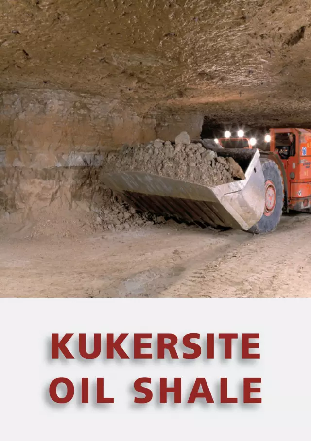
Frontcover: Estoniamine
Backcover: OilshaleseamBwithbryozoans(photobyAllanLiivamägi)
©MTÜGEOGuideBaltoscandia,2007
Kukersite oil shale. MTÜ GEOGuide Baltoscandia. Tallinn, 2007.
ISBN978-9985-9834-2-3
Release of this booklet in English was co-financedbyEnvironmentalInvestmentCentre,Estonia.ItwaspreviouslypublishedinEstonianandFinnishlanguagesundertheINTERREGIIIASouthernFinlandandEstoniaprogramme.
InMarch2006,apressreleaseannounced
that1billion(109)tonnesofoilshalehad
been produced in Estonia. It had taken
90yearstoreachthatamount.Oilshale
was first mined in 1916 and sent for
investigation to Petrograd. This date is
recognizedasthebeginningofthepro-
ductionofoilshaleinEstonia.
What is oil shale?
Whatisoilshaleandwhyhasitattracted
people’s attention for almost a cen-
tury? Ingeneral, oil shale is a rock that
comprises so much organic matter that
it will burn. As there is no generally
acknowledged definition of oil shale, it
isusuallyclassifiedasanargillaceous(or
carbonaceous), fine-grained, sedimen-
tary rock, inwhich solid organicmatter
orkerogenmustformatleast5to25%.
Likecoal,oilshalecanbeusedasafuel
withoutanypreliminaryprocessing.Oilis
derived by complex chemical processes.
InEstonia,thereareactuallytwoorganic-
rich burning rocks: graptolitic argillite
andkukersiteoilshale.
Graptolitic argillite
Graptolitic argillite, also known as
DictyonemashaleorDictyonemaargillite,
andlocallyknownasthe“frog’splate”,
is a dark, blackish- or greyish-brown,
fine-grainedclaystone.Itsorganic-matter
content reaches 15 to 20%. The rock
owesitscomplicatednametotheLower
Palaeozoicmarineorganism–graptolite
Dictyonema.Itsinitialname,Dictyonema
slate, is inaccurateon twocounts. First,
it is not a real slate clay belonging to
metamorphic rocks. Second, according
to the systematic revision in 1980s, the
fossils in the rock are not graptolites
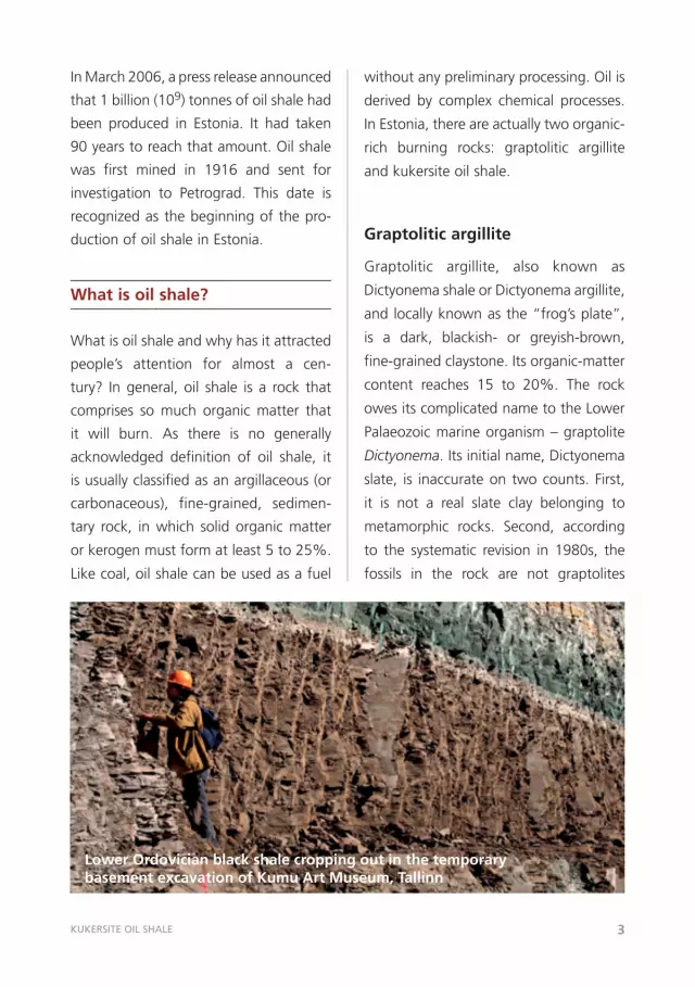
Lower Ordovician black shale cropping out in the temporary basement excavation of Kumu Art Museum, Tallinn
KUKERSITE OIL SHALE 3
4
from the genus Dictyonema but repre-
sentatives of the genus Rhabdinopora.
However, the terms Dictyonema shale
or Dictyonema argilliteare toostrongly
rootedinBaltoscandiatobereplaced.
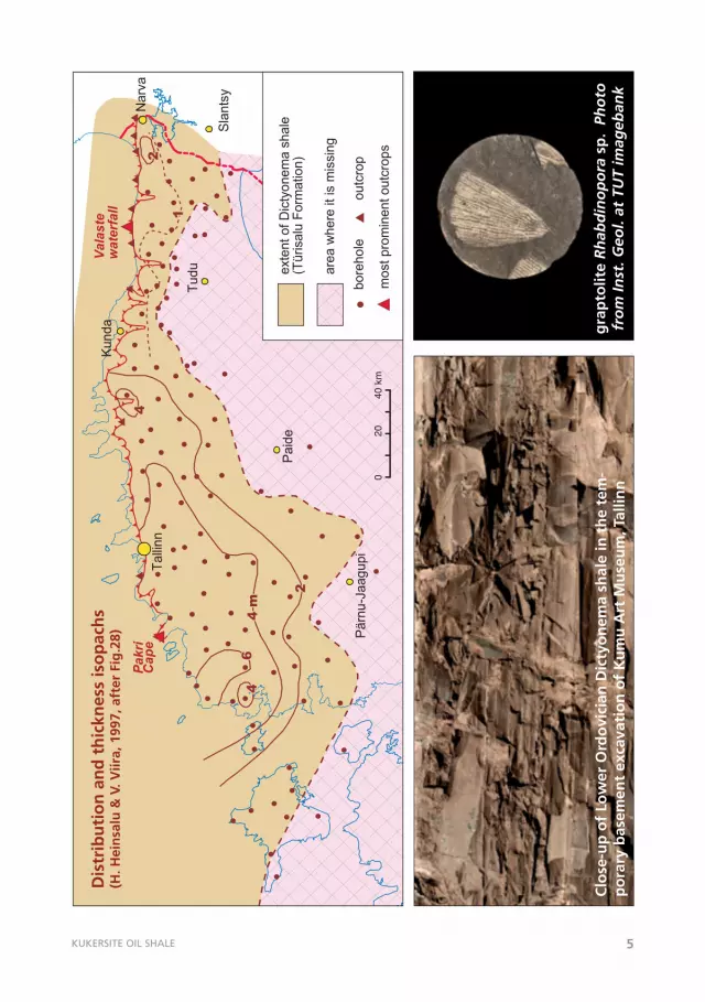
Graptolitic argillite occurs at the foot
of the North Estonian Klint in an area
extending from the Pakri Peninsula up
to the city of Narva. In the geologi-
cal section, it occurs right on the top
of shelly phosphorite formation and is
coveredbygreenish,glauconite-richclay.
The graptolitic argillite is at its thickest
(morethan4m)inwesternEstoniaand
its resources are estimated at 60 billion
tonnes. Formed in the Early Ordovician
marine basin some 480 million years
ago, it is much older than kukersite.
Owingtothelackoforganicmatter,the
calorific value of graptolitic argillite is
ratherlow(1,500to1,600kcal/kg)and,
therefore, it has not yet been used for
fuel.However,itcontainsseveralrareele-
ments,amongthemmolybdenum,vana-
dium,anduranium.From1949to1952,
graptoliticargillitewasminedatSillamäe
fortheproductionofuranium.Themine
occupied 24 km2 and was 15 m deep;
theminable layerwasametrethick.Of
some 250,000 tonnes of ore brought
outoftheground,morethan60tonnes
ofuraniumcompoundswereproduced.
Owingtotheverysmallyieldandprimi-
tive technology, the production of ura-
nium from local alum shale was found
tobe inefficientand theplant switched
toprocessingimportedrawmaterials.As
amatteroffact,Dictyonemaargillitehas
donemoreharmthangoodtopeople.In
thephosphoritequarryatMaardu,which
isnolongeroperating,Dictyonemaargil-
litewasremovedanddepositedinwaste
dumps; it was an overburden on the
phosphorite bed. As a result of its self-
ignition,substancesharmfultothehealth
ofpeoplereachedthegroundwater.This
wasonemorereasontoendthemining
ofphosphoriteinEstonia.
Oil shale or kukersite
To distinguish Estonian oil shale from
theotherkindsofoilshaleintheworld,
Estonian oil shale is called kukersite.
The name was derived from the word
Kuckers,theGermannameforKukruse
manor. The Russian palaeobotanist
Mihhail Zalesski is acknowledged as the
“godfather”ofkukersite.Duringthelast
century, oil shale was the most impor-
tant mineral resource of Estonia. It still
istoday.
What does oil shale consist of?
Thequalityofoilshaleisdeterminedby
the organic matter it contains. Besides
organicmatter,oilshalecontainsanon-
combustible mineral part comprised of
terrigenousandcalcareousmaterial.
KUKERSITE OIL SHALE 5
Paid
e
Pärn
u-J
aagupi
Pakri
Cape
Valaste
waterfall
Tudu
Sla
nts
y
0
20
40
km
exte
nt of D
icty
onem
a s
hale
(Türisalu
Form
ation)
are
a w
here
it is
mis
sin
g
bore
hole
outc
rop
most pro
min
ent outc
rops
Talli
nn
Narv
a
Kunda
11
22
2 2
44
44
4 m
4 m
66
Dis
trib
uti
on
an
d t
hic
knes
s is
op
ach
s(H
. Hei
nsa
lu &
V. V
iira,
199
7, a
fter
Fig
.28)
Clo
se-u
p o
f Lo
wer
Ord
ovi
cian
Dic
tyo
nem
a sh
ale
in t
he
tem
-p
ora
ry b
asem
ent
exca
vati
on
of
Ku
mu
Art
Mu
seu
m, T
allin
ng
rap
tolit
e R
hab
din
op
ora
sp
. Ph
oto
fro
m In
st. G
eol.
at T
UT
imag
eban
k
6
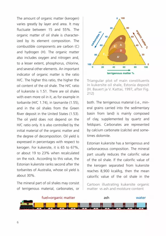
Theamountoforganicmatter(kerogen)
varies greatly by layer and area. It may
fluctuate between 15 and 55%. The
organic matter of oil shale is character-
ized by its element composition. The
combustiblecomponentsarecarbon (C)
and hydrogen (H). The organic matter
also includes oxygen and nitrogen and,
toa lesserextent,phosphorus,chlorine,
andseveralotherelements.Animportant
indicator of organic matter is the ratio
H/C.Thehigherthisratio,thehigherthe
oilcontentoftheoilshale.TheH/Cratio
ofkukersite is1.51.Thereareoil shales
withevenmoreoilinit,asforexamplein
torbanite(H/C1.74),intasmanite(1.55),
and in the oil shales from the Green
RiverdepositintheUnitedStates(1.53).
The oil yield does not depend on the
H/Cratioonly.Itisalsocontrolledbythe
initialmaterialoftheorganicmatterand
thedegreeofdecomposition.Oilyieldis
expressedinpercentageswithrespectto
kerogen.Forkukersite, it is65 to67%,
or about 19 to23%when recalculated
ontherock.Accordingtothisvalue,the
Estoniankukersiterankssecondafterthe
torbanitesofAustralia,whoseoilyieldis
about30%.
Themineralpartofoilshalesmayconsist
of terrigenous material, carbonates, or
both.Theterrigenousmaterial(i.e.,min-
eral grains carried into the sedimentary
basin from land) is mainly composed
of clay, supplemented by quartz and
feldspars. Carbonates are represented
bycalciumcarbonate(calcite)andsome-
timesdolomite.
Estoniankukersitehasaterrigenousand
carbonaceous composition.Themineral
part usually reduces the calorific value
of theoil shale. If the calorific valueof
the kerogen separated from kukersite
reaches 8,900 kcal/kg, then the mean
calorific value of the oil shale in the
F1A'
D
A
B
E
100
80
60
40
20
0
terrigenous matter %
carb
onat
es %
organic matter %
100
80
60
40
20
0
100806040200
Cartoon illustrating kukersite organic matter vs ash and moisture content
Triangular plot of main constituents in kukersite oil shale, Estonia deposit (H. Bauert ja V. Kattai, 1997, after Fig. 212)
fuel=organic matter ash water
KUKERSITE OIL SHALE 7
deposit in Estonia is 3,600 kcal/kg. On
combustion, the mineral constituents –
mostly carbonates – disintegrate. Thus,
as a result of oil-shale combustion, we
obtain heat but also many residual or
ballastsubstances.Inathousandtonnes
ofoilshale, thecombustiblepart forms
350tonnesandwater100;550tonnes
remain as ash. In the case of mineral
coal,thesevaluesare850,50,and100
tonnes,respectively.Hence,oilshaleisa
low-gradefuel.
Theenvironmentalproblemsarisingfrom
oil-shale production are also related to
oil-shale composition and geological
conditions. After mining and benefi-
ciation,muchlimestoneremainsunused
and is deposited in waste dumps. Oil-
shale waste and waste heaps may be
consideredarather innocentproduction
residue; however, from time to time
they are subject to self-ignition.On the
combustion of enriched oil shale, there
remainsash,whichalsohastobedepos-
ited. The most toxic waste comes from
theoil-shalechemical industry. Innorth-
western Estonia, oil-shale mines cover
450km2,whichforms15%ofthecoun-
ty’sareaor1%ofEstonia’sterritory.The
electrical power stations using oil shale
emit much carbon dioxide and other
gases; the groundwater regime, and
oftenalso thewaterquality, are altered
inmined-outareas.Thus,theproduction
andconsumptionofoilshalechangethe
environment. With the development of
theoilshaleindustry,moreattentionhas
tobepaidtoitseffects.
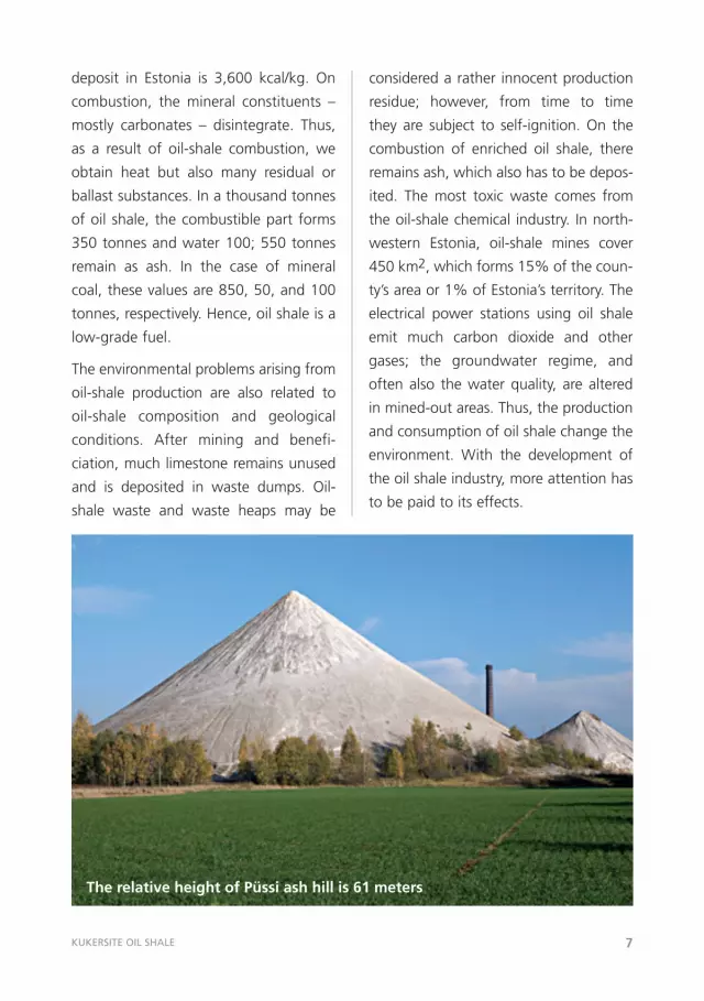
The relative height of Püssi ash hill is 61 meters
8
How did kukersite oil shale form?
Large-scale production and the ever-
growingconsumptionofoilshaleledto
an urgent need for scientific studies. In
the first decade after the II World War,
several Soviet institutions had mining
problems. In Estonia, the relevant stud-
ies were carried out only in the mining
department of the Tallinn Polytechnic
Institute (now Tallinn University of
Technology). In the beginning of the
1950s, the activities of local Estonian
researchinstitutionsandresearchersrose
to the fore. The amount of informa-
tion related togeology,mining technol-
ogy, and the oil-shale chemical industry
increased.Muchfactualandassessment
material on oil shale accumulated, but
detailed theoretical studies were prac-
tically absent. Despite the efforts of
geologists and oil-shale chemists, the
problems related to the formation of
kukersite have not yet been unambigu-
ouslyresolved.Themainquestion isthe
originof theorganicmatter, itsdecom-
position degree, and the conditions of
sedimentation. Most investigators agree
thatmarinealgaeweretheinitialsource
oftheorganicmatterintheoilshale.In
theOrdovician,onlyalgaethrivedevery-
where in water basins, as at that time
therewerenohigherplants.Theyplayed
animportantroleinprovidingtheEarth’s
atmospherewithoxygenandcreatinga
favourableenvironmentforotherorgan-
isms. Opinions differ about the further
alterationofalgae,theinitialmaterialof
kerogen. Geologists maintain that the
algalstructuresoccurinthekukersiteoil
shaleinanunchangedstateorthatthey
haveundergoneonlysmallchanges.This
opinion is based on the idea expressed
in 1917 by Zalesski. Zalesski studied
kukersite under a microscope and con-
cluded that kukersite was formed by
micro-organisms now extinct. Because
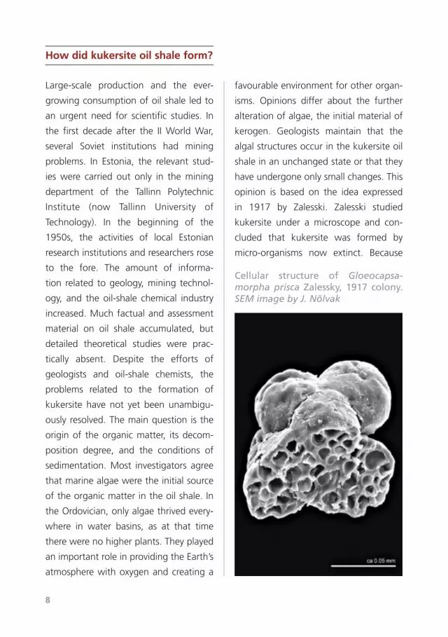
Cellular structure of Gloeocapsamorpha prisca Zalessky, 1917 colony. SEMimagebyJ.Nõlvak
KUKERSITE OIL SHALE 9
Riga
Novgorod
Tallinn
Stockholm
Vilnius
Moscow
010
020
0 km
blac
k gr
apto
litic
sha
le
calc
areo
us m
arl
biom
icrit
ic k
imes
tone
clay
ey m
arl
supp
osed
mar
gin
ofse
dim
enta
tion
area
mar
gin
of k
uker
site
OM
accu
mul
atio
n ar
ea
DA
NIS
H-P
OLI
SH
DE
PR
ES
SIO
N
LO
WL
AN
D
Mos
cow
Stoc
khol
m
Hel
sink
i
Min
sk
Rig
a
Viln
ius
LO
WL
AN
D
CA
RB
ON
AT
E
SH
EL
FC
AR
BO
NA
TE
S
HE
LF
mai
n ku
kers
iteac
cum
ulat
ion
area
mai
n ku
kers
iteac
cum
ulat
ion
area
Ku
kru
se a
ge
se
dim
en
ts
(R. M
änn
il, e
t al
., 19
86, a
fter
Fi
g. 5
.2.2
)
10
ofitssimilaritytothepresentdayplank-
tonicalgaGloeocapsa,thekukersitealga
was named Gloeocapsamorpha prisca.
This ideahaswithstoodthetestoftime
because the kukersite kerogen is very
difficult to investigate; it does not dis-
solve (or it dissolves only in very small
amounts in most organic solutions). In
the 1950s, oil-shale chemists criticized
Zalesski’sideas.Theymaintainedthatthe
initial organic material of kukersite had
changed greatly through time; that the
structural elements of algae are impos-
sible to recognize;and that, inall likeli-
hood, kukersite had been formed from
theremainsof representativesofall the
marineplantsandanimalsexistingthen.
Ontheirdecomposition,newhigh-molec-
ular colloidal compounds were formed
whose lumps recall algal structuresonly
superficially.Laterkerogenstudiesunder
anelectronmicroscope(SEM)havecon-
firmed M. Zalesski’s ideas rather than
refuted them. In the studies of the last
decade, chemists have also returned to
algal structures. Kukersite is believed to
have been deposited in shallow coastal
waters where algae might have formed
extensive mats. Along with the organic
matter,calcareousmaterialandclaypar-
ticlesaccumulated(theyreachedthesea
fromland).Whenassessingthedepthof
the sedimentary basin, one has to bear
inmindthatalgaecanliveonlyatdepths
reachablebysunlight.
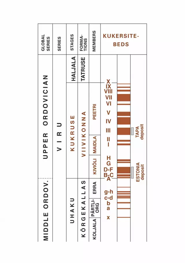
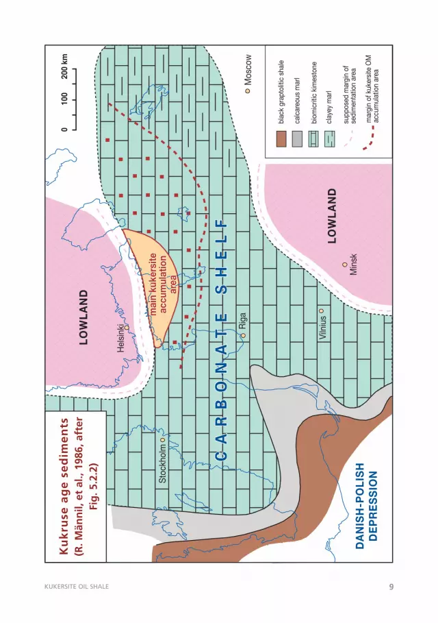
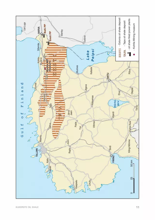
The extent of oil shale in Estonia
Estonian oil shale, kukersite, formed at
theendoftheMiddleOrdovicianandin
thebeginningoftheLateOrdovician.Itis,
therefore,some20millionyearsyounger
than graptolitic argillite. Kukersite
formsthinneror thickerhorizontalbeds
betweengreylimestoneandiswelltrace-
able because of its light brown colour.
Stratigraphically, kukersite occurs within
the Uhaku and Kukruse stages, where
upto50 layerswithvaryingthicknesses
havebeencounted.The seams thatare
minedinnorth-westernEstoniaoccurin
thelowerpartoftheKukruseStage.The
oil-shale seams are thickest in the area
betweenthecitiesofRakvereandNarva
(Estonia deposit) and continue behind
theNarvaRiverandLakePeipsi intothe
Leningrad District (Leningrad deposit).
Oil-shaleminingwasstarted inthearea
whereitsseamswerethickestandwhere
the interbedding limestone layers were
notthickenoughtohampermining.The
individual kukersite seams (but already
toothintobeproductiveandwithcon-
siderably lowered organic matter con-
tent) can be traced westwards even
in the area west of Tallinn. Eastwards,
these seams extend several dozen kilo-
metres, from Narva to St. Petersburg.
In the south, they are traceable up to
the Juuru–Järva-Jaani–Mustvee line. A
fewkerogengrainshavebeen found in
KUKERSITE OIL SHALE 11
Oudo
vaSlan
tsyUst-L
uga
Lake
Peip
si
Pihk
va
järv
Võrts-
järv
Gulf of Finland
Rapla
Rapla
Haap
salu
Haap
salu
Lihula
Lihula
Paldi
ski
Keila
Keila
Maar
duMa
ardu
Kehr
aKe
hra
Paide
Paide
Türi
Türi
Tapa
Tapa
Rakv
ere
Rakv
ere
Kiviõ
liKi
viõli
Kund
aKu
nda
Silla
mäe
Jõhv
iJõ
hvi
TART
UTA
RTU
PÄRN
USi
ndi
Sind
i
Kilin
gi-Nõ
mme
Kilin
gi-Nõ
mme
Vilja
ndi
Vilja
ndi
Karks
i-Nuia
Karks
i-Nuia
Tõrva
Tõrva
Elva
Elva Ot
epää
Otep
ääPõ
lvaPõ
lvaRä
pina
Räpin
a
Põlts
amaa
Põlts
amaa
Jõge
vaJõ
geva
Mustv
ee
Kalla
steVõ
hma
Võhm
a
Kohtl
a-Jä
rveKo
htla-
Järve
NARV
A
Ko
htla
MP
mus
eum
Ko
htla
MP
mus
eum
Juur
uJu
uru
Rapla
Järva
-Ja
ani
TALL
INN
025
50 k
m
Ees
ti P
PBal
ti P
P
TAPA
TAPA
EESTI
EESTI
- oi
l sha
le-f
ired
pow
er p
lant
s
TAPA
- Ta
pa
oil s
hale
dep
osit
EESTI
- E
ston
ia o
il sh
ale
dep
osit
- K
ohtla
Min
ing
mus
eum
12
drilling cores in contemporaneous lime-
stones(UpperOrdovicianKukruseStage)
in a vast area extending from Gotska
Sandön Island in Sweden as far as the
eastern boundary of Novgorod District.
Southwards, kerogenadditionhasbeen
noticedinthecoredrocksinthevicinity
ofLakeVõrtsjärv.
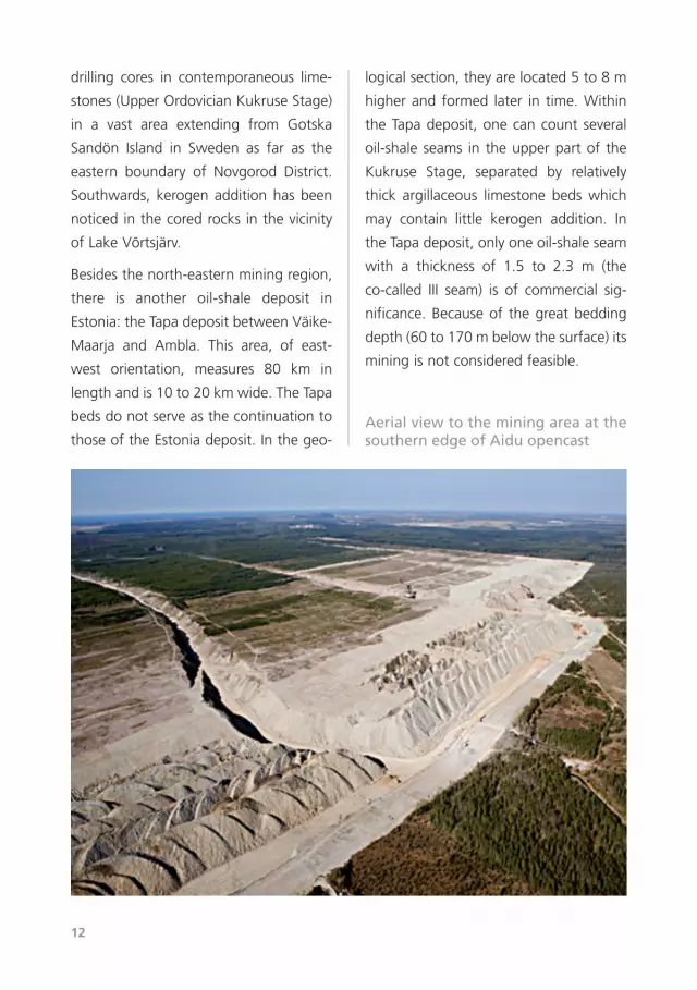
Besidesthenorth-easternminingregion,
there is another oil-shale deposit in
Estonia:theTapadepositbetweenVäike-
Maarja and Ambla. This area, of east-
west orientation, measures 80 km in
lengthandis10to20kmwide.TheTapa
bedsdonotserveasthecontinuationto
thoseoftheEstoniadeposit.Inthegeo-
logicalsection,theyarelocated5to8m
higherand formed later in time.Within
theTapadeposit,onecancountseveral
oil-shaleseams in theupperpartof the
Kukruse Stage, separated by relatively
thick argillaceous limestone beds which
may contain little kerogen addition. In
theTapadeposit,onlyoneoil-shaleseam
with a thickness of 1.5 to 2.3 m (the
co-called III seam) is of commercial sig-
nificance.Becauseof thegreatbedding
depth(60to170mbelowthesurface)its
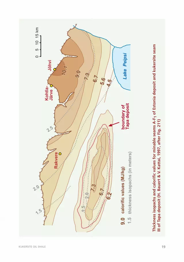
miningisnotconsideredfeasible.
Aerial view to the mining area at the southern edge of Aidu opencast
KUKERSITE OIL SHALE 13
Kohtla-
Järve
Jõhvi
Rakvere
5 km
N
Lake
Pei
psi
clo
sed m
ines
field
s o
f active m
ines a
nd o
pencasts
explo
red fie
lds o
f th
e d
eposit
(pro
spective a
reas for
furt
her
min
ing)
post-
Devonia
n e
rosio
nal lin
e o
f th
ekukers
ite o
il shale
form
ation
Ulja
ste
Põhj
a-K
iviõ
li
Uus
Kiv
iõli
Kiv
iõli
Pada
Koh
ala
Ubja
Tam
mik
u
Viru
Esto
nia
Som
pa
Oja
-m
aa
Aht
me
Käv
anr
.2nr
.4
Seli
Oan
du
Sond
a
Tudu
Kab
ala
Rak
vere
Kõn
nuH
alja
la
Peip
si
Puha
tu Perm
iskü
la
Nar
va
Viiv
ikon
na-
Sirg
ala
Kiv
iõli
Tam
mik
uSo
mpa
Aht
me
Käv
anr
.2nr
.4Kohtla
Viru
Esto
nia
Nar
va
Viiv
ikon
na-
Sirg
ala
Põhj
a-K
iviõ
liU
bja
Aid
u
Esto
nia
min
e
Su
bd
ivis
ion
s o
f th
e E
sto
nia
de
po
sit
(H. B
auer
t &
V. K
atta
i, 19
97, a
dap
ted
fro
m F
ig. 2
08 )
14
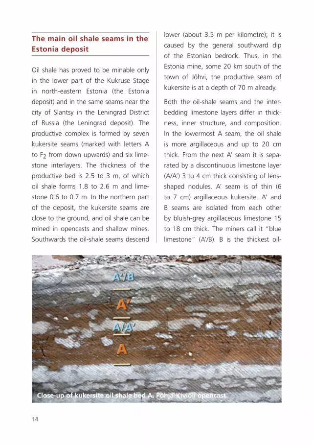
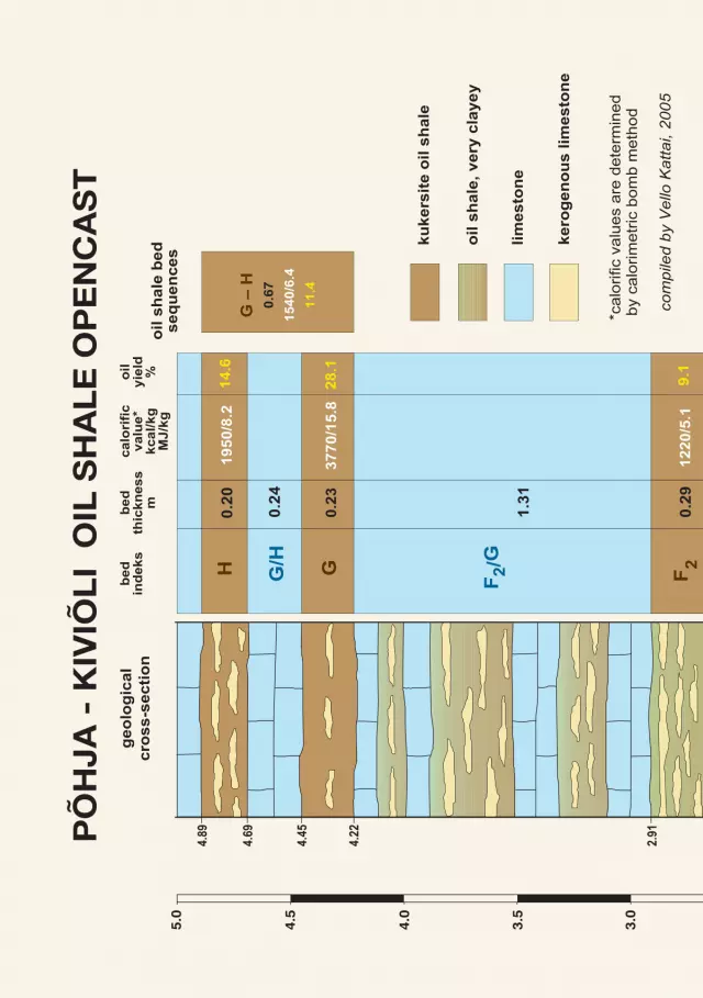
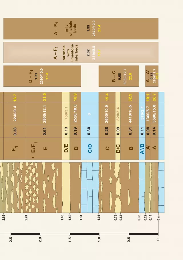
The main oil shale seams in the Estonia deposit
Oilshalehasprovedtobeminableonly
in the lower part of the Kukruse Stage
in north-eastern Estonia (the Estonia
deposit)andinthesameseamsnearthe
city of Slantsy in the Leningrad District
of Russia (the Leningrad deposit). The
productive complex is formed by seven
kukersite seams (marked with letters A
toF2fromdownupwards)andsixlime-
stone interlayers. The thickness of the
productive bed is 2.5 to 3 m, of which
oil shale forms 1.8 to 2.6 m and lime-
stone0.6to0.7m.Inthenorthernpart
of the deposit, the kukersite seams are
closetotheground,andoilshalecanbe
mined in opencasts and shallow mines.
Southwardstheoil-shaleseamsdescend
lower (about 3.5 m per kilometre); it is
caused by the general southward dip
of the Estonian bedrock. Thus, in the
Estoniamine,some20kmsouthofthe
town of Jõhvi, the productive seam of
kukersiteisatadepthof70malready.
Both the oil-shale seams and the inter-
bedding limestone layersdiffer in thick-
ness, inner structure, and composition.
In the lowermost A seam, the oil shale
is more argillaceous and up to 20 cm
thick. From thenextA’ seam it is sepa-
ratedbyadiscontinuouslimestonelayer
(A/A’)3to4cmthickconsistingoflens-
shaped nodules. A’ seam is of thin (6
to 7 cm) argillaceous kukersite. A’ and
B seams are isolated from each other
bybluish-greyargillaceous limestone15
to18cmthick.Theminerscall it“blue
limestone” (A’/B). B is the thickest oil-
Close-up of kukersite oil shale bed A, Põhja-Kiviõli opencast
KUKERSITE OIL SHALE 15
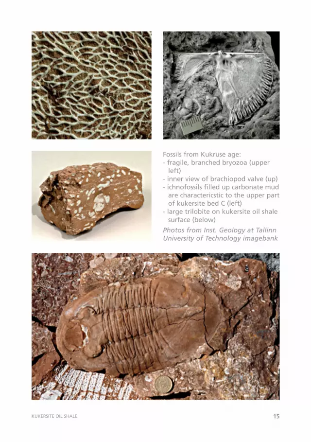
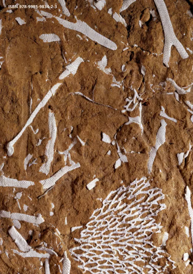
Fossils from Kukruse age:- fragile, branched bryozoa (upper
left)- inner view of brachiopod valve (up)- ichnofossils filled up carbonate mud
are charactericstic to the upper part of kukersite bed C (left)
- large trilobite on kukersite oil shale surface (below)
PhotosfromInst.GeologyatTallinnUniversityofTechnologyimagebank
00.5
1.0
1.5
2.0
2.5
3.0
3.5
4.0
4.5
5.0
0 m
0.14
0.22
0.33
0.64
0.73
1.01
1.31
1.50
1.63
2.24
2.62
2.91
4.45
4.22
4.69
4.89
AB
B/CC
D/E DE
E/F1
F1
F2GH A’
A’/B
C/D
F2/G
G/H
bed
indeks
bed
thickness
m
0.14
0.08
0.11
0.31
0.09
0.28
0.30
0.19
0.61
0.38
0.29
1.31
0.23
0.24
0.20
3590/15.0
1360/5.7
570/2.4
4410/18.5
820/3.4
0
2600/10.9
2520/10.6
750/3.1
0.13
2900/12.1
2240/9.4
1220/5.1
3770/15.8
1950/8.2
26.7
10.1
32
.9
19
.4
18
.9
21
.5
16
.7
9.1
28
.1
14
.6
calo
rifi
cvalu
e*
kcal/kg
MJ/k
g
oil
yie
ld%
A –
A’
0.2
22
70
0/1
1.3
20
.1
B –
C
0.6
8
3030/1
2.7
22.6
D –
F1
1.3
1
2390/1
0.0
17.8
G –
H
0.6
7
1540/6
.4
11.4
A –
F1
oil s
hale
wit
h
lim
esto
ne
inte
rbed
s
2.6
2
2110/8
.8
15.7
A –
F1
on
ly
oil
sh
ale
be
ds
1.9
9
2870/1
2.0
21.4
PÕ
HJA
- K
IVIÕ
LI
OIL
SH
AL
E O
PE
NC
AS
Tg
eo
log
ica
l
cro
ss
-se
cti
on
oil
sh
ale
be
ds
eq
ue
nc
es
ku
ke
rsit
e o
il s
ha
le
oil
sh
ale
, v
ery
cla
ye
y
lim
es
ton
e
ke
rog
en
ou
s l
ime
sto
ne
*ca
lorific v
alu
es a
re d
ete
rmin
ed
by c
alo
rim
etr
ic b
om
b m
eth
od
com
pile
d by
Vel
lo K
atta
i, 20
05
18
shale seam with the highest kerogen
content(upto50%).Inthecentralpart
ofthedeposit,theseamis0.75to0.8m
thick; the thickness decreases uniformly
towards the periphery of the deposit.
ThekukersiteoftheBseamischocolate-
brown with a very fine lamination and
accumulationsoffragilewhitecalcareous
fossil skeletons on bedding planes. This
seamisusuallyrecognizedasthetypical
oilshaleofEstonia.TheBseamissepa-
rated from the overlying C seam by an
elongated,nodular-likebeige-colorlime-
stone(B/C),whichis10to12cmthick.
In the C seam, the content of kerogen
is somewhat lower than in theB seam,
and on two or three levels the seam is
penetrated by discontinuous interlayers
of limestone lenses. The seam is about
30cmthick.Intheuppermostquarterof
theseamtherearelotsofwormburrows
(trace fossils), 0.5 cm in diameter, filled
with very light-grey calcareous material,
which provides the rock’s cross-section
withawhite-dottedoutlook.Minerscall
thiskindofrock“horseskin”.
The limestone layer C/D is situated in
the middle of the productive seam and
divides it into two almost equal halves.
Thelimestoneisrelativelypure,itsthick-
nessis20to25cm.Frequently,theseam
breaks into twoequalparts in themid-
dle; from this comes its popular name,
“twin-limestone”. The seam is easily
recognizable and traceable in all mines
and boreholes and serves as a good
marker level for the whole productive
seam. The D seam immediately above
the “twin-limestone” is represented by
slightlyargillaceousoilshalewithathick-
nessupto20cm.
The limestone between the D and E
seams is beige because of the addition
of kerogen. It is hard, its thickness is
uneven, it is occasionally interrupted,
anditisupto15cmthick.Owingtoits
peculiar colour, it is often called “pink
limestone” (D/E).TheEseamrankssec-
ondinkerogencontent(55%)afterthe
Bseamintheoil-shaleproductivebed.In
this seam, the contentof the limestone
nodules is also lower. The thickness of
theseamisabout40cm.Itdiffersfrom
theBseaminitssomewhatmorereddish
shade;also,thedebrisoffossils ismore
evenlydistributed in the rock.Upwards,
threeseamswithoutdistinctboundaries
canbedistinguished:E/F1,F1,andF2.
TheE/F1seamisnotatypical limestone
interlayer. In it, kukersite and lumps of
kerogenic limestoneare irregularly inter-
twined. Limestone nodules are irregular
in shape, with angular contours; there
are small hollows filledwith calcite and
pyrite crystals. It is practically impos-
sible to separate limestone lumps and
kukersite. Limestone makes up 50% or
more of the seam. Owing to the hard-
nessandcompactnessoftheseam, it is
called“devil’s skin”.Theboundarywith
KUKERSITE OIL SHALE 19
10.1
10.1
9.0
9.0
7.9
7.9
6.7
6.7
5.6
5.6
4.5
4.5
6.7
6.77
.37.3
6.2
6.2
2.5
2.0
1.5 1.5
1.5
2.0
2.0
1.5
Lake
Pei
psi
Ko
htl
a-
Järv
eJõ
hvi
calo
rifi
c v
alu
es (
MJ/k
g)
9.0
thic
kn
ess iso
pach
s (
in m
ete
rs)
bo
un
dary
of
Tap
a d
ep
osit
0
5 1
0 1
5 km
Rakvere
Thic
knes
s is
op
ach
s an
d c
alo
rifi
c va
lues
fo
r m
inab
le s
eam
s A
-F1
of
Esto
nia
dep
osi
t an
d k
uke
rsit
e se
am
III o
f Ta
pa
dep
osi
t (H
. Bau
ert
& V
. Kat
tai,
1997
, aft
er F
ig. 2
11)
20
theoverlyingF1seamistransitionaland
isusuallyplacedon the levelwhere the
shape and bedding of limestone lumps
become more regular. The oil shale in
theF1 seam is relatively rich inkerogen
(about40%)and thereare sixor seven
horizontaldiscontinuouslimestoneinter-
layers.Thethicknessoftheseamreaches
60to70cm.Thereisnodistinctbound-
arybetween theF1andF2 seams. F2 is
consideredtheuppermost30cmofthe
complex in which the kerogen content
steadily decreases. The seam is rich in
limestonenodules.
Usually, the limestone with a smooth
uppersurfaceundertheAseamservesas
thefloorofthemine.Inthecaseofthe
thinandargillaceousAseam,theupper
surfaceoftheA’/Bseammayalsobeleft
as the floor, depending on the mining
method. Mining is usually carried out
downtotheF2seam,butsometimesitis
alsosubjecttoproduction.
All rocks in the productive bed contain
many fossils or their crushed skeletal
particles–debris. In theKukruseStage,
palaeontologists have found some 360
speciesof fossils (two to three times as
muchasinotherstages).Frequently,the
fossilslookveryattractive.Onemayfind
here white, lace-like whitish bryozoans
and well-preserved trilobites. Abundant
tracefossilsarealsoindicativeoffavour-
ablelivingconditions.
The history of oil shale produc-tion in Estonia
Generally known stories about the dis-
covery of oil shale tell of a peasant
who built a stove from oil shale which
burnedupalongwiththefirewoodand
about herder boys who threw into the
fire pieces of oil shale which, to their
astonishment,caught fire.Oil shalehad
attractedscientists’attentionbytheend
of the eighteenth century. Since then,
therehavebeenperiodswhenoil shale
wasamatteroftopicalinterestandother
periodswhen it fell intooblivion.Earlier
experimentsandstudies,includingthose
byGeorgi(1791)andHelmersen(1839),
ledtotheconclusionthattherockscould
beusedforproducingheatandtaroroil
forlocalneeds.Duringtheinvestigations
inthesecondhalfofthenineteenthcen-
tury, it was discovered that the thickest
oil-shale beds lay near Kukruse manor.
Fr.Schmidt,afounderofEstoniangeol-
ogy, named the part of the geological
section, which comprised oil shale, the
Kukruse Stage. Thereafter, chemists at
Tartu University studied the chemical
compositionofoilshaleandcametothe
conclusion that its production was not
usefulbecauseofthesmall thicknessof
theseamsanditshighashcontent.The
oil shale was forgotten once again. A
newwaveofinterestinoilshalearosein
1910.DuringWorldWarI,whenthecity
KUKERSITE OIL SHALE 21
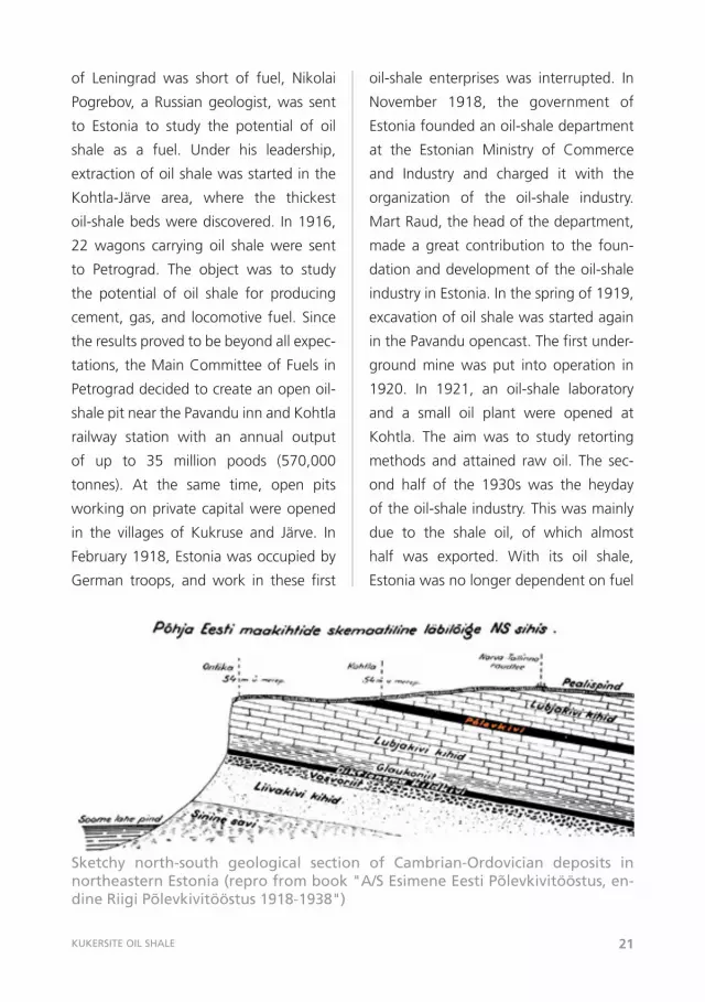
oil-shale enterprises was interrupted. In
November 1918, the government of
Estoniafoundedanoil-shaledepartment
at the Estonian Ministry of Commerce
and Industry and charged it with the
organization of the oil-shale industry.
MartRaud,theheadofthedepartment,
made a great contribution to the foun-
dationanddevelopmentoftheoil-shale
industryinEstonia.Inthespringof1919,
excavationofoilshalewasstartedagain
inthePavanduopencast.Thefirstunder-
ground mine was put into operation in
1920. In 1921, an oil-shale laboratory
and a small oil plant were opened at
Kohtla. The aim was to study retorting
methods and attained raw oil. The sec-
ond half of the 1930s was the heyday
oftheoil-shaleindustry.Thiswasmainly
due to the shale oil, of which almost
half was exported. With its oil shale,
Estoniawasnolongerdependentonfuel
of Leningrad was short of fuel, Nikolai
Pogrebov, aRussiangeologist,was sent
to Estonia to study the potential of oil
shale as a fuel. Under his leadership,
extractionofoilshalewasstartedinthe
Kohtla-Järve area, where the thickest
oil-shalebedswerediscovered. In1916,
22 wagons carrying oil shale were sent
to Petrograd. The object was to study
the potential of oil shale for producing
cement,gas,and locomotive fuel.Since
theresultsprovedtobebeyondallexpec-
tations,theMainCommitteeofFuels in
Petrograddecidedtocreateanopenoil-
shalepitnearthePavanduinnandKohtla
railway station with an annual output
of up to 35 million poods (570,000
tonnes). At the same time, open pits
workingonprivatecapitalwereopened
in the villages of Kukruse and Järve. In
February1918,Estoniawasoccupiedby
German troops, and work in these first
Sketchy north-south geological section of Cambrian-Ordovician deposits in northeastern Estonia (repro from book "A/S Esimene Eesti Põlevkivitööstus, en-dine Riigi Põlevkivitööstus 1918-1938")
22
KUKERSITE OIL SHALE 23
fromothercountries.Bythelastyearsof
theindependentEstonianrepublic,seven
enterpriseshadinvestedtheircapitalinto
theoil-shaleindustry.Oneofthose–the
stock company “The First Estonian Oil-
ShaleIndustry”–workedonthenational
capital, the other six on foreign private
capital.DuringtheyearsoftheEstonian
Republic,abitmorethan5milliontonnes
ofoilshaleweremined.Oilshalewasthe
cheapestandmostavailable fueland its
pricewasstable.Thereservesofoilshale
wereexpectedtolastfor4,000to5,000
years.ItwasthenationalprideofEstonia,
ourbrowngold.
During World War II, Germany showed
interestinoilshaleasamineralresource
of strategic significance and started
founding new oil-shale enterprises in
Estonia.Intheautumnof1944,Russian
troops invaded Estonia. The retreating
German army destroyed the retorting
plants at Sillamäe, Kohtla, and Kiviõli;
some of the mines were burnt, others
inundated.Theelectricalpower stations
usingoil shaleatPüssiandKohtla-Järve
werealsodisabled.
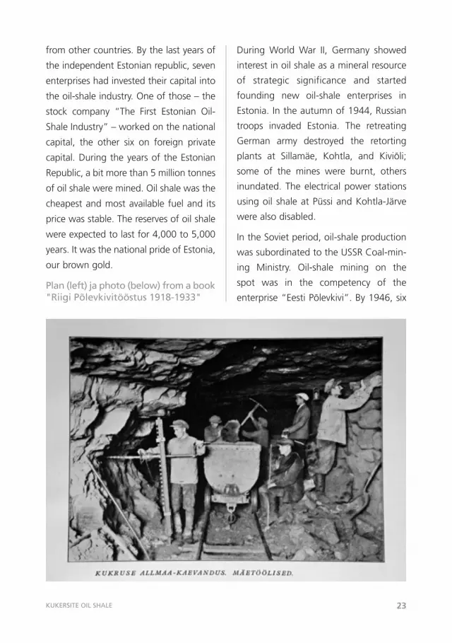
IntheSovietperiod,oil-shaleproduction
wassubordinatedtotheUSSRCoal-min-
ing Ministry. Oil-shale mining on the
spot was in the competency of the
enterprise“EestiPõlevkivi”.By1946,sixPlan (left) ja photo (below) from a book "Riigi Põlevkivitööstus 1918-1933"
24
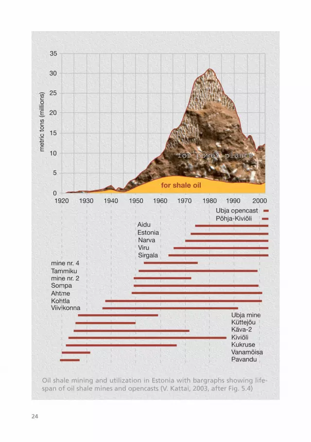
1920 1930 1940 1950 1960 1980 20000
10
5
15
20
35
for shale oil
1970 1990
30
25
for power plants
AiduEstoniaNarvaViruSirgala
mine nr. 4Tammikumine nr. 2SompaAhtmeKohtlaViivikonna
Ubja mineKüttejõuKäva-2KiviõliKukruseVanamõisaPavandu
Põhja-KiviõliUbja opencast
met
ric t
ons
(mill
ions
)
Oil shale mining and utilization in Estonia with bargraphs showing life-span of oil shale mines and opencasts (V. Kattai, 2003, after Fig. 5.4)
KUKERSITE OIL SHALE 25
mineshadbeenrestoredandthepre-war
output regained. The oil-shale industry
was developed, first of all, to provide
Leningrad and Estonia with household
gas.Upto1960,themainoil-shalecon-
sumersweretheKohtla-JärveandKiviõli
shaleoil plants and the railway. Fineoil
shalewasusedasafuelat localelectri-
calpowerstations.From1960to1970,
large electrical power stations using oil
shale were launched – Baltic Thermal
Power Station in 1965 and Estonian
ThermalPowerStationin1973.Withthis
the structure of oil-shale consumption
wasaltered:now80%ofminedoilshale
was used for producing energy. At the
sametime,newminesandmoreoilshale
wereurgentlyneeded.Thus,in1962an
opencastwasopenedatSirgala.In1965
theVirumine(mineNo.7)got itsstart.
TheNarvaopencaststartedtooperatein
1970and theEstoniamine in1972.At
thesametime,theminefieldsinthecen-
treoftheEstonianoil-shaledepositwere
exhausted. Mining operations shifted
inevitablytowardstheperipheralpartsof
thedeposit,where theminable seam is
thinner,itsqualitylower,anditssituation
deeper,makingexcavationmoreexpen-
sive and labour-intensive. Oil-shale pro-
ductionreacheditspeakin1980,when
31.3 million tonnes of oil shale were
minedand themined volumeexceeded
theconsumption.Sincethelaunchofthe
SosnovyiBornuclearpowerplant,about
50 km east of Narva, less oil shale was
needed for producing electricity in the
joint electricity distribution system with
NW Russia, and the production of oil
shalestartedtodropfromyeartoyear;in
1990,itwaslessthan10milliontonnes,
an amount equal to the amount of oil
shale produced in 1960. Oil-shale pro-
ductionhasstabilizedatalevelof13-14
milliontonnesperyear.Thegreaterpart
of theproducedoil shale is stillusedas
fuelattheelectricalpowerstations.Since
the1960s,Estoniahasbeenthegreatest
oil-shale producer and consumer in the
world. Inthe1980sabouttwo-thirdsof
the world’s oil-shale output came from
Estonia.
The production of oil shale and its use
asarawmaterialintheoilandchemical
industry and power engineering caused
seriousenvironmentalproblemsinnorth-
eastern Estonia during the early and
middle period of the oil-shale industry.
Environmental effects and the resulting
immediatehazardsweregreatest in the
1980s. To date, attention is focused on
theproblemsrelatedtotheenvironmental
pollutioncausedbybothexcavationand
furtheruseofoil shale.Muchhasbeen
done at the electrical power stations at
Narva. For example, after installation of
new boilers and up-to date purification
facilities,theemissionofcarbondioxide,
nitrogen, and sulphur compounds has
beenreducedsubstantially.
26
Oil shale elsewhere in the world
The world’s oil shale reserves are
immense.AccordingtotheUnitedStates
GeologicalSurvey,theyreach410billion
tonnes. Oil shale formations are known
throughout thewholePhanerozoic,and
its deposits have been recorded from
morethan600placesin30countries.The
largestreservesareintheUnitedStates.
Since oil shale is of local importance, it
has local names. The oil shale studied
in more detail include the Green River
depositintheUnitedStates,torbanitein
Australia, alum shale in Sweden, kuker-
siteinEstonia,andtheoilshaleofJordan.
Estoniaiscurrentlythegreatestproducer
of oil shale in the world. Oil shale is
also mined in Russia, Australia, China,
and Brazil (in the latter three countries
only for oil production).Oil shale is not
excavated in France, Scotland, Canada
and several other states anymore. They
prefer to use crude oil, which is much
cheaper.However,theshale-oiloutputis
marginalcomparedtocrudeoil,thedaily
worldwideproductionofwhichis75mil-
lionbarrels.Thedevelopmentoftheoil-
shaleindustryintheworldisimmediately
controlledbythepriceofcrudeoil.Inthe
UnitedStates,shaleoilisconsideredone
ofthepossiblealternativestooil,butnot
untiltheremotefuture.InEstonia,green
powerandalsonuclearpowerhavebeen
suggestedasalternatives.
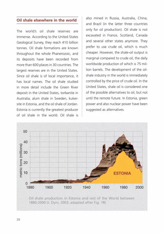
1880 1900 1920 1940 1960 1980 20000
1010
20
30
40
50
ESTONIA
met
ric t
ons
(mill
ions
)
Oil shale production in Estonia and rest of the World between 1880-2000 (J. Dyni, 2003, adapted after Fig. 18)
KUKERSITE OIL SHALE 27
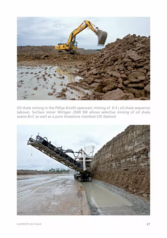
Oil shale mining in the Põhja-Kiviõli opencast: mining of D-F1 oil shale sequence (above). Surface miner Wirtgen 2500 SM allows selective mining of oil shale seams B+C as well as a pure limestone interbed C/D (below)
28
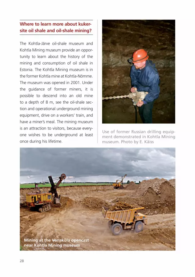
Where to learn more about kuker-site oil shale and oil-shale mining?
The Kohtla-Järve oil-shale museum and
KohtlaMiningmuseumprovideanoppor-
tunity to learn about the history of the
mining and consumption of oil shale in
Estonia.TheKohtlaMiningmuseumisin
theformerKohtlamineatKohtla-Nõmme.
Themuseumwasopenedin2001.Under
the guidance of former miners, it is
possible to descend into an old mine
toadepthof8m,seetheoil-shalesec-
tionandoperationalundergroundmining
equipment,driveonaworkers’train,and
haveaminer’smeal.Theminingmuseum
isanattractiontovisitors,becauseevery-
one wishes to be underground at least
onceduringhislifetime.
Mining at the Vanaküla opencast near Kohtla Mining museum
Use of former Russian drilling equip-ment demonstrated in Kohtla Mining museum. Photo by E. Käiss
KUKERSITE OIL SHALE 29
SÕNASELETUSI
Alum shale (in Scandinavia) – Middle Cambrian to Lower Ordovician sedimentary
rockrichinorganicmatterandpyrite,whichaccumulatedundergenerallylowoxygen
concentrations
Argillite–prevailinglymicrolaminatedsedimentaryrockformedasaresultofthecon-
solidationofclay,breaksintothinplates
Barrel–aunitofliquidcapacityorvolumeintheUSAandGreatBritain.IntheUSAa
barrelofoilisequalto42gallons(=159liters)
Brachiopod –marineanimalwithbivalveshellhavingapairofarmsbearingtentacles
forcapturingfood
Bryozoa–sessilemarineanimalfoundinbranchingcoloniesinkukersiteoilshale
Calorific value –amountofheatgeneratedbyagivenmass(solidandliquidfuels)
orvolume(gaseousfuels)offuelwhenitiscompletelyburned.Inpractice,itisoften
measuredinkilocalories(1kcal=4.1868kJ)
Cyanobacteria–aphotosyntheticbacteria,generallyblue-greenincolorandinsome
speciescapableofnitrogenfixation.Cyanobacteriawereoncethoughttobealgae.Also
calledblue-green alga
Detritus–crushedskeletalremainsofdeadorganismsfloatinginwaterordeposited
onthebottomofwaterbasins
Dictyonema–agenusofgraptoliteswidespreadinPalaeozoicseas
Dictyonema shale –atermuseduptothepresenttodenoteacertainkindofoilshale
inEstonia(seealsograptoliticargillite)
Dolomite – both a carbonate rock and mineral CaMg(CO3)2 consisting of calcium-
magnesiumcarbonate
Fossil –theremainsofaonce-livingorganisms,preservedintherocks
Georgi, Johann Gottlieb (Ivan Ivanovitch) 31.12.1729 – 27.10.1802 – a Russian
explorerofGermanorigin,naturalistandethnographer,academicianofSt.Petersburg
Academyof Sciences (1783).Undertook longer expeditions inRussia, hisworks also
30
compriseinformationaboutEstoniaandtheEstonians
Glauconite–Agreenishmineralofthemicagroup,ahydroussilicateofpotassium,
iron, aluminum, or magnesium, (K,Na)(Al,Fe,Mg)2(Al,Si)4O10(OH)2, found in green-
sandandusedasafertilizerandwatersoftener
Graptolite–anextinctcolonialmarineanimalwithaplanktonicwayoflife.Common
inPalaeozoicseas
Graptolitic argillite –earlierknownasDictyonemashale.AnEarlyOrdovicianblackish
brownargillaceousrockrichinorganicmatterandoftenwithgraptolitefossils(corre-
spondstotheTürisaluFormationinEstonia)
Helmersen, Gregor von 11.10.1803–15.02.1885–RussiangeologistofGermanori-
ginborninEstonia,academicianofSt.PetersburgAcademyofSciences(1850).Founder
of thenationalGeological Survey in Russia, supervisor of geologicalmapping. In his
workshealsodealsamongotherswithEstonianerraticbouldersandoilshalefinds
Kerogene–insolublepartoforganicmatterinoilshales
Kukersite–Estonianoilshale,deriveditsnamefrom"Kuckers",whichistheGerman
namefortheKukrusemanorlocatedinNEEstonia
Ordovician–thesecondperiodofthePalaeozoiceraprecededbytheCambrianand
followedbytheSilurian.Startedca490millionyearsagoandlasted45millionyears.
TheperiodissubdividedintotheEarly,MiddleandLateOrdovician
Plankton – the collectionof tinyplants andanimals floating freely inwater; phyto-
plankton–plants,zooplankton–animals
Pogrebov, Nikolai Fjodorovitch17.11.1860–10.01.1942–Russianhydrogeologist.
In1916he studied thegeologyof Estonianoil shale and itsproductionpossibilities,
publishedaseriesofpapersonthissubjectin1916-1923
Pood–anoldRussianunitofweightequivalentto16.38kg
Pyrite –abrass-coloredmineral,FeS2,commoninEstoniansedimentaryrocks
Raud, Märt23.07.1878–04.03.1952(accordingtootherdatathedateandplaceof
deathnotknown)–engineer,founderanddeveloperofEstonianoilshaleindustryin
1918—1940,chairmanofthecompanyTheFirstEstonianOilShaleIndustry
KUKERSITE OIL SHALE 31
Retorting–drydistillation,heatingtoahightemperatureinanairlesscondition
Schmidt, Carl Friedrich 27.01.1832 – 21.11.1908 – Baltic German geologist and
botanistborninEstonia,academicianofSt.PetersburgAcademyofSciences(1885).His
mainpapersdealwiththestratigraphyandfaunaofLowerPalaeozoicrocksinEstonia
andneighboringareas.AcknowledgedasthefounderofEstoniangeology
Series–asubdivisionofasystem,rocksformedduringarelevanttimepriod,thename
oftheseriesismostlyformedbyplacinganadverb(Lower,Middle,Upper)infrontof
thenameofacorrespondingsystem
Stage–asubdivisionintheclassificationofstratifiedrocksformedatthesameagein
acertainregion;thenameofthestageisderivedfromthenameofthelocalitywhere
itoccursinitstypicalform
Stratigraphy–branchofgeologystudyingtheagesuccessionofrocksandtheirrela-
tionsinspace
Tasmanite –oilshalefromtheIslandofTasmania
Terrigenous–originatingfromland,oflandorigin
Torbanite–namedafterTorbaneHill inScotland, isablackoil shalewhoseorganic
matteristelalginitederivedfromlipid-richBotryococcusandrelatedalgalforms
Trilobite –anextinctarthropodthatwasabundantinPaleozoictimes;hadanexoskel-
etondividedintothreeparts
Zalesski, Mihhail Dmitrievitch 15.09.1877- 22.12.1946 – Russian palaeobotanist,
investigatorofplantremains incoalsandoilshale.Thefounderofalgalstructures in
kukersitekerogene

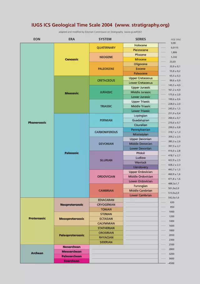
IUGS ICS Geological Time Scale 2004 (www. stratigraphy.org)
Holocene
Pleistocene
Pliocene
Miocene
Oligocene
Eocene
Paleocene
Upper Cretaceous
Lower Cretaceous
Upper Jurassic
Middle Jurassic
Lower Jurassic
Upper Triassic
Middle Triassic
Lower Triassic
Lopingian
Guadalupian
Cisuralian
Pennsylvanian
Mississipian
Upper Devonian
Middle Devonian
Lower Devonian
Ludlow
Wenlock
Llandovery
Upper Ordovician
Middle Ordovician
Lower Ordovician
Furongian
Middle Cambrian
Lower Cambrian
Pridoli
QUATERNARY
EON ERA SYSTEM SERIES AGE (Ma)
adapted and modified by Estonian Commission on Stratigraphy (www.gi.ee/ESK/)
NEOGENE
CRETACEOUS
CARBONIFEROUS
PALEOGENE
JURASSIC
TRIASSIC
DEVONIAN
ORDOVICIAN
CAMBRIAN
SILURIAN
PERMIAN
EDIACARAN
CRYOGENIAN
TONIAN
STENIAN
ECTASIAN
CALYMMIAN
STATHERIAN
OROSIRIAN
RHYACIAN
SIDERIAN
Cenozoic
Phanerozoic
Paleozoic
Mesozoic
Proterozoic
Archean
Neoproterozoic
Mesoproterozoic
Neoarchean
Mesoarchean
Paleoarchean
Eoarchean
Paleoproterozoic
0,00
0,0115
1,806
5,332
23,03
33,9 ± 0,1
55,8 ± 0,2
65,5 ± 0,3
99,6 ± 0,9
145,5 ± 4,0
161,2 ± 4,0
175,6 ± 2,0
199,6 ± 0,6
228,0 ± 2,0
245,0 ± 1,5
251,0 ± 0,4
260,4 ± 0,7
270,6 ± 0,7
299,0 ± 0,8
318,1 ± 1,3
359,2 ± 2,5
385,3 ± 2,6
397,5 ± 2,7
416,0 ± 2,8
418,7 ± 2,7
422,9 ± 2,5
428,2 ± 2,3
443,7 ± 1,5
460,9 ± 1,6
471,8 ± 1,6
488,3±1,7
501,0±2,0
513,0±2,0
542,0±1,0
630
850
1000
1200
1400
1600
1800
2050
2300
2500
2800
3200
3600
~4500
ISBN 978-9985-9834-2-3


