Evidence for Late Pleistocene uplift at the Somma-Vesuvius apron near Pompeii
Aldo Marturano a,⁎, Giuseppe Aiello b, Diana Barra b
a Istituto Nazionale di Geofisica e Vulcanologia, sez. Osservatorio Vesuviano, via Diocleziano 328, 80124 Naples, Italyb Dipartimento di Scienze della Terra, Università di Napoli Federico II, 80136 Naples, Italy
Detailed stratigraphic and micropalaeontological analyses of samples from boreholes at the Somma-Vesuviusapron, between Pompeii and the sea, allowed reconstruction of Late Quaternary palaeoenvironmentalevolution of the Sarno coastal plain. In all, 116 samples were recovered from seven boreholes drilled from2–10 m a.s.l. to 16.5–26 m b.s.l. Microfossil assemblages, with special regard to benthic foraminifersand ostracods, were used to reconstruct the depositional palaeoenvironment. Fossil remains show that all thepre-79 AD fossiliferous sediments from 2 to −24 m a.s.l. were deposited in shallow marine waters for a longtime despite an appreciable sea level rise. The data indicate alternation of both shallow marine and subaerialconditions during the last ~15 kyr, evidencing ground uplift of the area of about 75 m at a rate of ~5 mm/year.Marine sediment accumulation (~6 m/kyr) and tectonic uplift long offset the sea level rise, and as aconsequence, submerged areas remained the same as well.
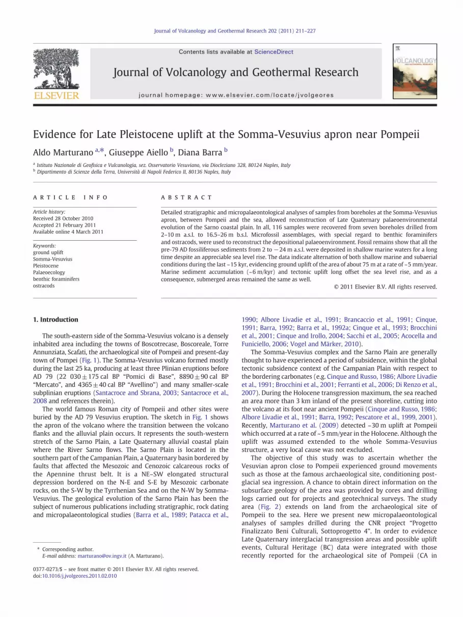
The south-eastern side of the Somma-Vesuvius volcano is a denselyinhabited area including the towns of Boscotrecase, Boscoreale, TorreAnnunziata, Scafati, the archaeological site of Pompeii and present-daytown of Pompei (Fig. 1). The Somma-Vesuvius volcano formed mostlyduring the last 25 ka, producing at least three Plinian eruptions beforeAD 79 (22 030±175 cal BP “Pomici di Base”, 8890±90 cal BP“Mercato”, and 4365±40 cal BP “Avellino”) and many smaller-scalesubplinian eruptions (Santacroce and Sbrana, 2003; Santacroce et al.,2008 and references therein).
The world famous Roman city of Pompeii and other sites wereburied by the AD 79 Vesuvius eruption. The sketch in Fig. 1 showsthe apron of the volcano where the transition between the volcanoflanks and the alluvial plain occurs. It represents the south-westernstretch of the Sarno Plain, a Late Quaternary alluvial coastal plainwhere the River Sarno flows. The Sarno Plain is located in thesouthern part of the Campanian Plain, a Quaternary basin bordered byfaults that affected the Mesozoic and Cenozoic calcareous rocks ofthe Apennine thrust belt. It is a NE–SW elongated structuraldepression bordered on the N-E and S-E by Mesozoic carbonaterocks, on the S-W by the Tyrrhenian Sea and on the N-W by Somma-Vesuvius. The geological evolution of the Sarno Plain has been thesubject of numerous publications including stratigraphic, rock datingand micropalaeontological studies (Barra et al., 1989; Patacca et al.,
1990; Albore Livadie et al., 1991; Brancaccio et al., 1991; Cinque,1991; Barra, 1992; Barra et al., 1992a; Cinque et al., 1993; Brocchiniet al., 2001; Cinque and Irollo, 2004; Sacchi et al., 2005; Acocella andFuniciello, 2006; Vogel and Märker, 2010).
The Somma-Vesuvius complex and the Sarno Plain are generallythought to have experienced a period of subsidence, within the globaltectonic subsidence context of the Campanian Plain with respect tothe bordering carbonates (e.g. Cinque and Russo, 1986; Albore Livadieet al., 1991; Brocchini et al., 2001; Ferranti et al., 2006; Di Renzo et al.,2007). During the Holocene transgression maximum, the sea reachedan area more than 3 km inland of the present shoreline, cutting intothe volcano at its foot near ancient Pompeii (Cinque and Russo, 1986;Albore Livadie et al., 1991; Barra, 1992; Pescatore et al., 1999, 2001).Recently, Marturano et al. (2009) detected ~30 m uplift at Pompeiiwhich occurred at a rate of ~5 mm/year in the Holocene. Although theuplift was assumed extended to the whole Somma-Vesuviusstructure, a very local cause was not excluded.
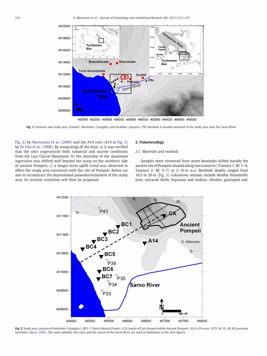
The objective of this study was to ascertain whether theVesuvian apron close to Pompeii experienced ground movementssuch as those at the famous archaeological site, conditioning post-glacial sea ingression. A chance to obtain direct information on thesubsurface geology of the area was provided by cores and drillinglogs carried out for projects and geotechnical surveys. The studyarea (Fig. 2) extends on land from the archaeological site ofPompeii to the sea. Here we present new micropalaeontologicalanalyses of samples drilled during the CNR project “ProgettoFinalizzato Beni Culturali, Sottoprogetto 4”. In order to evidenceLate Quaternary interglacial transgression areas and possible upliftevents, Cultural Heritage (BC) data were integrated with thoserecently reported for the archaeological site of Pompeii (CA in
Fig. 1. Vesuvius and study area (framed). Boreholes (triangles) and localities (squares). PSc borehole is located eastward of the study area near the Sarno River.
212 A. Marturano et al. / Journal of Volcanology and Geothermal Research 202 (2011) 211–227
Fig. 2) by Marturano et al. (2009) and the A14 core (A14 in Fig. 2)by Di Vito et al. (1998). By integrating all the data: a) it was verifiedthat the sites experienced both subaerial and marine conditionsfrom the Last Glacial Maximum; b) the shoreline of the maximumingression was shifted well beyond the scarp on the southern sideof ancient Pompeii; c) a longer-term uplift trend was observed toaffect the study area consistent with the site of Pompeii. Below weaim to reconstruct the depositional palaeoenvironment of the studyarea. Its tectonic evolution will then be proposed.
Fig. 2. Study area. Location of boreholes (triangles): (BC1-7) Beni Culturali Project; (CA) Insulboreholes (Barra, 1992). The same symbols, the coast and the course of the Sarno River are
2. Palaeoecology
2.1. Materials and methods
Samples were recovered from seven boreholes drilled outside theancient site of Pompeii situated along two transects (Transect 1: BC 1–4;Transect 2: BC 5–7) at 2–10m a.s.l. Borehole depths ranged from16.5 to 26 m (Fig. 3). Calcareous remains include benthic foraminifertests, ostracod shells, bryozoan and mollusc (bivalve, gastropod and,
a of Casti Amanti within Ancient Pompeii; (A14) A14 core; (P33, 34, 35, 39, 43) previousused as landmarks in the next figures.
Fig. 3. Schematic stratigraphic columns of boreholes (for location see Figs. 1, and 2).a) Post 79 AD sediments; b) pumice deposits; c) sands, clays, palaeosoils and humifiedlayers; d) block lavas and scoria. Stars represent marine fossiliferous samples (seeTable 1); ellipses the 14C dated samples.
213A. Marturano et al. / Journal of Volcanology and Geothermal Research 202 (2011) 211–227
infrequently, scaphopod) fragments, echinoid spines and very rarebrachiopods.
Assemblages of benthic foraminifers and ostracods were used toreconstruct the depositional palaeoenvironment of Quaternarysediments in the Sarno coastal plain. A total of 116 samples(Table 1) were examined. Each core sample was cleaned to removesurface material in contact with drilling mud. Samples weredisaggregated using hydrogen peroxide and washed through a63-μm mesh; the dried samples were sieved to obtain the N125-μmfraction. Benthic foraminifers and ostracods, picked out from thecoarser fraction, were recorded in 37 samples. Three samples,devoid of foraminifers and ostracods, yielded bryozoan or bivalveremains, and 76 were barren. All species are given a semi-quantitative rating, according to their relative abundance: rare(1–3 specimens), uncommon (4–7 specimens), common (8–20specimens), abundant (N 20 specimens).
In all, 61 benthic foraminifer species, pertaining to 27 genera, and53 species from 26 genera of ostracods were identified and listed(Table 2; Appendix A). Eight species are left in open nomenclature andfour given affinitive status: Aurila sp. Callistocythere sp., Neonesideasp., Propontocypris sp. because only young instars were found;Hemicytherura sp., Pseudocytherura aff. P. strangulata, Sahnicytheresp., Sclerochilus sp., Semicytherura aff. S. diafora, S. aff. S. paradoxa,Xestoleberis aff. X. labiata, Xestoleberis sp. due to the poor preservationof the material. One erased valve of a freshwater candonid specieswas considered allochthonous (i.e. transported from continentalwaters).
2.2. Palaeoenvironmental interpretation
All of the autochthonous species found in the study area aremarineand presently living in the Mediterranean. Areal and bathymetricdistribution, as well as the assemblages characteristic of differentbiotopes, are well defined in the literature. Data on benthicforaminifers are taken from Le Calvez and Le Calvez (1958), Blanc-Vernet (1969), Pujos (1976), Haake (1977), Blanc-Vernet et al. (1979),Vénec-Peyré (1984), Sgarrella and Barra (1985), Jorissen (1987),
Sgarrella et al. (1985), Sgarrella andMoncharmont Zei (1993), Donniciand Serandrei Barbero (2002), Aiello et al. (2006) and Frezza andCarboni (2009); ostracod data are reported by Müller (1894), Rome(1964), Barbeito-Gonzalez (1971), Uffenorde (1972), Breman (1976),Bonaduce et al. (1976, 1977, 1988), Yassini (1979), Peypouquet andNachite (1984), Arbulla et al. (2001, 2004), Triantaphyllou et al. (2005)and Aiello et al. (2006). Information from ecological literature wasintegrated with unpublished data on Recent Mediterranean assem-blages (Aiello and Barra).
On the basis of the known distributional data (depth range,sedimentary substrate, and presence of marine vegetation) five groupsof species were defined:
(1) Species found exclusively or preferentially in the infralittoralzone, on sand, silt and muddy sand, without vegetation.Benthic foraminifers: Adelosina elegans, A. longirostra, Ammoniatepida, A. parkinsoniana A. perlucida, Astrononion stelligerum,Elphidium complanatum, E. crispum, E. cuvilleri, E. incertum,E. punctatum, Elphidium sp. A, Quinqueloculina bosciana, Q.poeyana,Q. lamarckiana, Q. stelligera, Sigmoilina tricosta, Triloculinagibba, T. schreibersiana.Ostracods: Aurila prasina, Callistocythere protracta, Cytherettaadriatica, C. subradiosa, Eucytherura angulata, Hemicytheruragracilicosta, Heterocythereis voraginosa, Leptocythere bituberculata,L. macella, L. ramosa, Loxoconcha affinis, L. ovulata, Pontocythereturbida, Semicytherura incongruens, S. sulcata, Urocythereis flex-icauda, U. margaritifera.
(2) Species found exclusively or preferentially in the infralittoral zonewith vegetation cover.Benthic foraminifers: Asterigerinata mamilla, Lamarckina scabra,Massilina secans, Planorbulina mediterranensis, Rosalina bradyi, R.floridana, R. obtusa, Sigmoilina grata, Triloculina oblunga, T. rotunda.Ostracods: Neocytherideis subulata, Paradoxostoma triste, P.versicolor, Pontocypris pellucida, Sclerochilus levis, Sclerochilus sp.
(4) Species living in the infralittoral to upper circalittoral zones.Benthic foraminifers: Adelosina mediterranensis, Ammonia gai-mardi,Bolivina striatula,Bulimina elongata,Elphidiumgranosum,E.macellum, E. pulvereum, Lagena clavata, Nonionella turgida,Quinqueloculina contorta,Q. pygmaea,Q. seminulum,Q. tenuicollis,Reussella spinulosa, Sigmoilina costata, Spiroloculina excavata,Stainforthia complanata, Textularia calva.Ostracods: Carinocythereis whitei, Cistacythereis (H.) turbida, Costabatei, C. edwardsi, Hemicytherura defiorei, Microcytherura fulva,Semicytherura dispar, S. mediterranea, S. rarecostata, S. stilifera.
(5) Species occasionally present in the infralittoral zone, morefrequently found on circalittoral muddy substrate.Benthic foraminifers: Bulimina aculeata, Cornuspira involvens,Miliolinella subrotunda, Quinqueloculina stalkeri.Ostracods: Eucytherura complexa.
The fossil assemblages in question are mainly associated tochanges in sediment granulometry. Species composition and semi-quantitative assemblage analysis allow different palaeoenvironmentsto be recognized in the borehole sediments.
Assemblages:(1) Bryozoan or bivalve fragments, in coarse to medium sands;
samples: BC1-51, BC1-45; BC6-133. Upper infralittoral or mesolittoralzone, strongly influenced by high-energy waters.
214 A. Marturano et al. / Journal of Volcanology and Geothermal Research 202 (2011) 211–227
(2) Rare foraminifers, typical of very shallow waters (Ammoniaparkinsoniana, Buccella granulata, Elphidium crispum), very rare echinoidand mollusc remains, in coarse to fine sands; samples: BC2-85, BC2-83,BC2-82, BC2-81, BC2-78, BC2-76; BC4-214; BC5-164, BC5-162, BC5-159;BC6-127, BC6-125. Deposition occurred in high-energy marine waters,within the upper part of the infralittoral zone.
(3) Low abundance and diversity recorded in assemblages A and Band the presence of shell debris indicate a depositional environmentranging from upper infralittoral zone to infralittoral fringe (possiblyreaching the mesolittoral zone).
(4) Very rare ostracods, typical of very shallow waters (Palmo-concha turbida, Pontocythere turbida); samples: BC2-75; BC4-198. Inthe former sample echinoid spines also occur. Medium-fine sands.Upper part of the infralittoral zone.
(5) Relatively rich and well-diversified foraminifer and ostracodassemblages; samples: BC2-87, BC2-86, BC2-84; BC3-109, BC3-108; BC5-
215A. Marturano et al. / Journal of Volcanology and Geothermal Research 202 (2011) 211–227
172, BC5-171, BC5-170, BC5-169, BC5-163, BC5-161, BC5-160, BC5-157,BC5-156; BC6-129, BC6-128, BC6-126; BC7-42, BC7-32, BC7-31. Coarse-fine sands tomuddy silts. Sedimentedwithin the upper infralittoral zone.A palaeoenvironment frequently characterized by vegetation is inferredfrom the common presence of phytophilous species.
(6) Rich and diversified assemblages consisting of foraminifer,ostracod, bryozoan, echinoid and mollusc remains. Both foraminifersand ostracod assemblages include very shallow (i.e. upper infralittoral)and lower infralittoral species; samples: BC7-40, BC7-39, BC7-37. Thesamples are characterized by very fine sands. Assemblages represent themaximum palaeodepth, within the infralittoral zone, probably notexceeding 20 m b.s.l.
Fossil remains show that all the fossiliferous sediments weredeposited in shallow marine waters. The palaeoenvironment rangesfrom the lower infralittoral zone characterized by muddy bottomswith vegetation, low energy and high abundance and diversity of theassemblages, to the upper infralittoral zone, infralittoral fringe andpossibly mesolittoral zone with generally coarser sediments, higherenergy, lean assemblages and low specific diversity.
The presence in sample BC7-39 of one valve of a freshwatercandonid species, clearly transported by fluvial waters, shows theproximity of the Sarno river mouth. The influence of fluvialsupply is suggested by the record of a group of foraminiferalspecies (A. parkinsoniana, A. longirostra, Q. seminulum, E. granosum,T. schreibersiana, T. trigonula), previously reported as common onsandy or pelitic-sandy bottoms in marine environments under theinfluence of fluvial waters (Pujos, 1976; Sgarrella and Barra, 1985;Sgarrella et al., 1985; Jorissen, 1988).
Fossiliferous samples pertain to pre-79 AD sequences, whilesediments younger than 79 AD are barren except sample BC1-45which yielded bivalve fragments. Core depth of fossiliferous depositsis generally deeper than 10–15 m b.s.l., except for BC2 that shallows at~5 m b.s.l.
3. Long-term deformation
Recently Marturano (2008) and Marturano et al. (2009) proposedto extend both single eruption upwelling and long-term grounddeformation at the Somma-Vesuvius volcano by utilizing strati-graphic, archaeological, micropalaeontological, archaeometric andpetrochemical data from Pompeii. A local cause was not excluded;therefore, new evidence is required to corroborate the hypothesisand it is necessary to take account of volcano-tectonic deformationin stratigraphic, sedimentological and palaeontological analysesperformed near the volcano in order to reconstruct the depositionalpalaeoenvironment.
The Cultural Heritage Project mainly focused on environmentalstudy close to Pompeii and, timewise, close to the 79 AD eruption,thus giving a partial, though detailed, picture of the site evolution(Pescatore et al., 1999, 2001; Ciarallo et al., 2003). Data from the sevenproject boreholes offer an opportunity to verify the dynamics ofthe area and, as we are interested in the long-term changes of theapron environment, the sediments older than 79 AD will beconsidered below.
The stratigraphic scheme of the BC boreholes is reported in Fig. 3together with the nearby sites of A14 and CA by Di Vito et al. (1998)and Marturano et al. (2009), respectively. The A14 and CA sites areclose to the seven boreholes of the Project andwill be considered here,focusing on the Scafati borehole data on the plain. To this latterlocation (Fig. 1), eastward of the study area, refers the stratigraphy(PSc) in Fig. 3 and peaty mud sediments at 5.2 and 10.8 m b.s.l. dated4500±320 and 5600±130 years BP, respectively (Barra et al.,1992a). At Pompeii six boreholes were drilled along the east andwestward alleys of the so-called “Insula of Casti Amanti” (location inFig. 2). Between the 79 AD deposits and an underlying shoshoniticlava body, the sequence (CA in Fig. 3, summarized by Marturano et al.,
2009) can be subdivided into three main layers. The middle layer, atpresent about 25 m a.s.l., revealed the ubiquitous presence ofmicrofossil remains, phonolitic pumice from the Mercato eruption(8890±90 cal. years), glass shard and ceramic pottery remnantscharacteristic of the Late Neolithic Diana Culture pottery (4300–3700BC). The pumice samples revealed a phonolitic composition withhomogeneous major and trace elements typical of the “Mercato”eruption, as named by Walker (1977), also known as “PomiciGemelle” (Delibrias et al., 1979) or “Ottaviano pumice” (Rolandiet al., 1993). The fall deposits of this eruption dispersed in an E–NEdirection (e.g. Mele et al., 2010), as generally occurs for plinian andsubplinian Vesuvian eruptions with the exception of that of 79 ADthat deposited ash and pumice primarily to the south and southeast ofthe volcano. Results of micropalaeontological analysis suggested thatsedimentation occurred in a high-energy marine paleoenvironment,like the upper part of the infralittoral zone, infralittoral fringe ormidlittoral zone.
Di Vito et al. (1998) documented at core A14 (location in Fig. 2)low sea level sediments at about 15 (A14a) and 24 m b.s.l. (A14b)dated 18–20 ka (sequence A14 in Fig. 3, from Di Vito et al., 1998).Radiocarbon dating of the humified levels under two lava blocks ofcore A14 revealed age inversion: an upper palaeosol dated 20300±200 BP and lower palaeosol dated 18700±280 BP (Di Vito et al.,1998). The age inversion of palaeosoils is generally a crucial point foranalysis of stratigraphic sequences. The large error used belowovercomes the obstacle as it permits confirmation of the averageuplift rate for longer, which is the goal of this article. However,anomalous age patterns through sediment cores are not rare,particularly when 14C dating is performed on organic matterdispersed in sediments with a complex accumulation history (DiVito et al., 1998). Therefore, caution is required in interpreting coreA14 (Di Vito et al., 1998; Milia et al., 2008). The two dates, calibratedto calendar years with the IntCal104 dataset (Reimer et al., 2004),are 22.7 and 24.7 cal. kyr BP, older than the volcanic bodies overlyingthe palaeosoils, and therefore, according to petrographical featuresof the lava flows, consistent with their emplacement precedingthe Pomici di Base-Pomici Verdoline activity (22–19 cal. kyr BP;Santacroce and Sbrana, 2003; Di Renzo et al., 2007; Santacroce et al.,2008).
As reported in the previous section, pre-79 AD marine sedimentsat BC holes are situated from 8 down to−24 m a.s.l., characterized bymicrofossil assemblages indicating shallow marine palaeoenviron-ments. Marine sediments at comparable depth are also reported insequence A14 (Fig. 3), where the elevation of the 14C dated samples(ellipses) is also indicated.
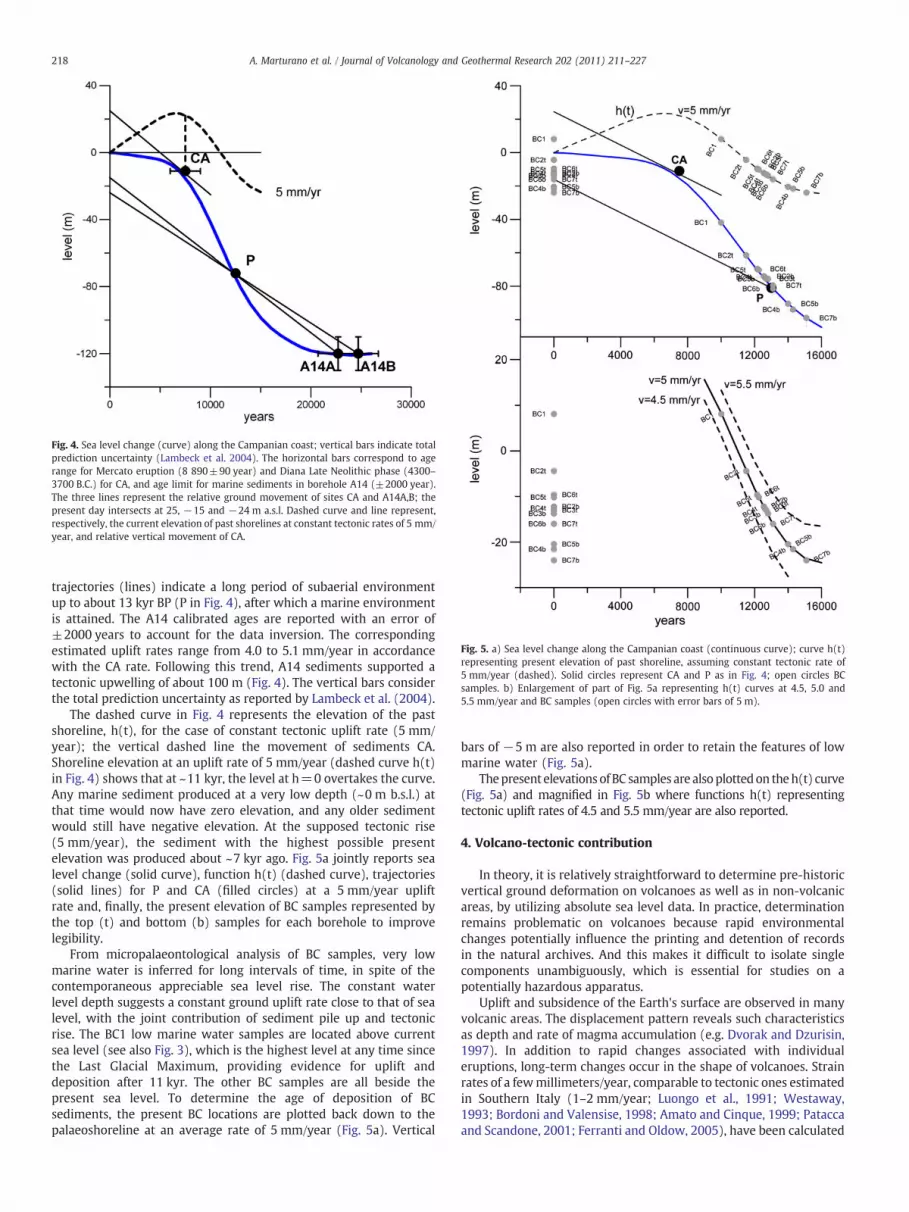
Recently, Lambeck et al. (2004), Lambeck and Purcell (2005),Pirazzoli (2005) and Stocchi and Spada (2008) evaluated thecomponents combining to produce sea level change after the lastdeglaciation and developed a predictive model for Late Pleistoceneand Holocene changes in relative sea level for the Italian coast. Theyconcluded that relative sea level is spatially variable along the Italianpeninsula and across its adjacent seas due to glacio-hydro-isostaticeffects, and sea level cannot be represented by a single time-dependent curve for the entire region. Their results primarily revealcoastal stability along the Tyrrhenian coast since the middlePleistocene, using the position of the MIS 5.5 horizon as marker(Lambeck et al., 2004; Antonioli et al., 2009). Absolute sea levelchange (solid curve in Fig. 4) is plotted by smoothing with a ninth-order polynomial the reconstruction by Lambeck et al. (2010).
According to Marturano et al. (2009), the solid line passingthrough point CA represents the CA site-level change from thesediment deposition (~7.5 kyr) to the present position (25 m a.s.l.),showing an average uplift rate of ~5 mm/yr. In Fig. 4 A14 sedimentsare also plotted at the present (A: 15 m b.s.l. B: 24 m b.s.l.) and at theiroriginal location back down to the palaeoshoreline as inferred bycalibrated ages (22.7 and 24.7 cal key BP). The A14 sediment
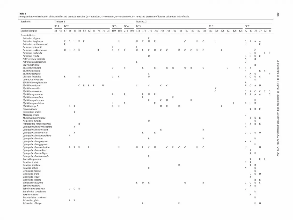
Table 2Semiquantitative distribution of foraminifer and ostracod remains (a=abundant, c=common, u=uncommon, r=rare) and presence of further calcareous microfossils.
ForaminiferidaAdelosina elegans RAdelosina longirostra C C U R R U U C U R C U C U C A A AAdelosina mediterranensis R U RAmmonia gaimardi R CAmmonia parkinsoniana U U C U R C C R U R C U C C R C C U C R CAmmonia perlucida U U R CAmmonia tepida U R C U CAsterigerinata mamilla A RAstrononion stelligerum R UBolivina striatula RBuccella granulata U R R R R R U R U U R R RBulimina aculeata R R RBulimina elongata C A U RCibicides lobatulus R R U R U A C U CCornuspira involvens RElphidium complanatum RElphidium crispum C R R R U C C C C A C A UElphidium cuvilleri RElphidium incertum C C A C C C CElphidium granosum R R R U R A A A A CElphidium macellum R RElphidium pulvereum R C U R UElphidium punctatum U R R R R U RElphidium sp. A R R R U U R R RLagena clavata R R RLamarckina scabra RMassilina secans UMiliolinella subrotunda R U RNonionella turgida U UPlanorbulina mediterranensis R R R R RQuinqueloculina berthelotiana R RQuinqueloculina bosciana R RQuinqueloculina contorta R R R U U U UQuinqueloculina lamarckiana RQuinqueloculina lata R R UQuinqueloculina poeyana R RQuinqueloculina pygmaea RQuinqueloculina seminulum R R U R U U R C U C R C C U C U UQuinqueloculina stalkeri RQuinqueloculina stelligera R RQuinqueloculina tenuicollis RReussella spinulosa R R RRosalina bradyi C RRosalina floridana R R RRosalina obtusa R A USigmoilina costata USigmoilina grata U U USigmoilina tenuis RSigmoilina tricosta R RSiphonaperta aspera R U R U R U C U CSpirillina vivipara R RSpiroloculina excavata U C R UStainforthia complanata RTextularia calva RTretomphalus concinnus U UTriloculina gibba R RTriloculina oblonga R R R U
216A.M
arturanoet
al./Journal
ofVolcanology
andGeotherm
alResearch
202(2011)
211–227
Triloculina plicata R UTriloculina rotunda R R R R R C U CTriloculina schreibersiana U R U U C U U UTriloculina trigonula R U C R
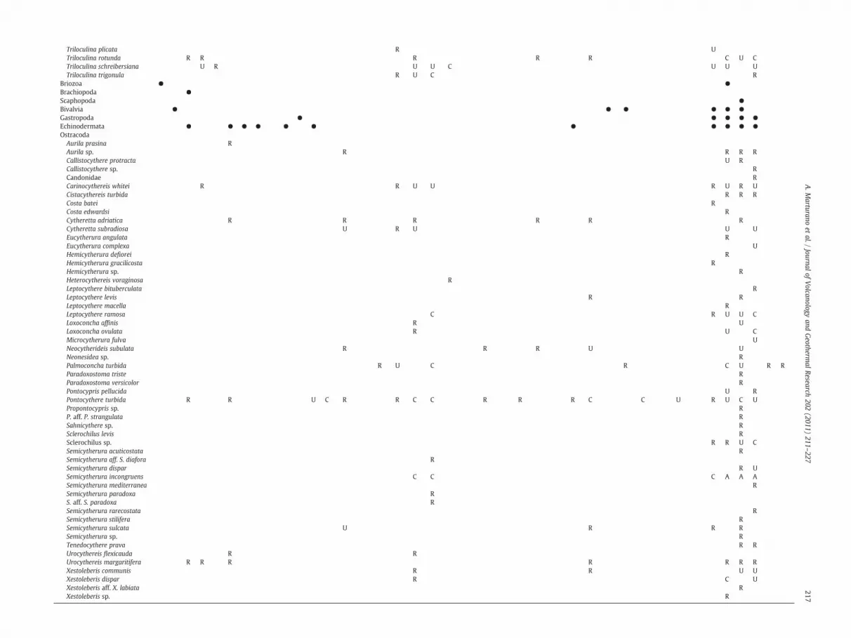
Briozoa ● ●Brachiopoda ●Scaphopoda ●Bivalvia ● ● ● ● ● ●Gastropoda ● ● ● ● ●Echinodermata ● ● ● ● ● ● ● ● ● ● ●OstracodaAurila prasina RAurila sp. R R R RCallistocythere protracta U RCallistocythere sp. RCandonidae RCarinocythereis whitei R R U U R U R UCistacythereis turbida R R RCosta batei RCosta edwardsi RCytheretta adriatica R R R R R RCytheretta subradiosa U R U U UEucytherura angulata REucytherura complexa UHemicytherura defiorei RHemicytherura gracilicosta RHemicytherura sp. RHeterocythereis voraginosa RLeptocythere bituberculata RLeptocythere levis R RLeptocythere macella RLeptocythere ramosa C R U U CLoxoconcha affinis R ULoxoconcha ovulata R U CMicrocytherura fulva UNeocytherideis subulata R R R U UNeonesidea sp. RPalmoconcha turbida R U C R C U R RParadoxostoma triste RParadoxostoma versicolor RPontocypris pellucida U RPontocythere turbida R R U C R R C C R R R C C U R U C UPropontocypris sp. RP. aff. P. strangulata RSahnicythere sp. RSclerochilus levis RSclerochilus sp. R R U CSemicytherura acuticostata RSemicytherura aff. S. diafora RSemicytherura dispar R USemicytherura incongruens C C C A A ASemicytherura mediterranea RSemicytherura paradoxa RS. aff. S. paradoxa RSemicytherura rarecostata RSemicytherura stilifera RSemicytherura sulcata U R R RSemicytherura sp. RTenedocythere prava R RUrocythereis flexicauda R RUrocythereis margaritifera R R R R R R RXestoleberis communis R R U UXestoleberis dispar R C UXestoleberis aff. X. labiata RXestoleberis sp. R
217A.M
arturanoet
al./Journal
ofVolcanology
andGeotherm
alResearch
202(2011)
211–227
Fig. 4. Sea level change (curve) along the Campanian coast; vertical bars indicate totalprediction uncertainty (Lambeck et al. 2004). The horizontal bars correspond to agerange for Mercato eruption (8 890±90 year) and Diana Late Neolithic phase (4300–3700 B.C.) for CA, and age limit for marine sediments in borehole A14 (±2000 year).The three lines represent the relative ground movement of sites CA and A14A,B; thepresent day intersects at 25, −15 and −24 m a.s.l. Dashed curve and line represent,respectively, the current elevation of past shorelines at constant tectonic rates of 5 mm/year, and relative vertical movement of CA.
Fig. 5. a) Sea level change along the Campanian coast (continuous curve); curve h(t)representing present elevation of past shoreline, assuming constant tectonic rate of5 mm/year (dashed). Solid circles represent CA and P as in Fig. 4; open circles BCsamples. b) Enlargement of part of Fig. 5a representing h(t) curves at 4.5, 5.0 and5.5 mm/year and BC samples (open circles with error bars of 5 m).
218 A. Marturano et al. / Journal of Volcanology and Geothermal Research 202 (2011) 211–227
trajectories (lines) indicate a long period of subaerial environmentup to about 13 kyr BP (P in Fig. 4), after which a marine environmentis attained. The A14 calibrated ages are reported with an error of±2000 years to account for the data inversion. The correspondingestimated uplift rates range from 4.0 to 5.1 mm/year in accordancewith the CA rate. Following this trend, A14 sediments supported atectonic upwelling of about 100 m (Fig. 4). The vertical bars considerthe total prediction uncertainty as reported by Lambeck et al. (2004).
The dashed curve in Fig. 4 represents the elevation of the pastshoreline, h(t), for the case of constant tectonic uplift rate (5 mm/year); the vertical dashed line the movement of sediments CA.Shoreline elevation at an uplift rate of 5 mm/year (dashed curve h(t)in Fig. 4) shows that at ~11 kyr, the level at h=0 overtakes the curve.Any marine sediment produced at a very low depth (~0 m b.s.l.) atthat time would now have zero elevation, and any older sedimentwould still have negative elevation. At the supposed tectonic rise(5 mm/year), the sediment with the highest possible presentelevation was produced about ~7 kyr ago. Fig. 5a jointly reports sealevel change (solid curve), function h(t) (dashed curve), trajectories(solid lines) for P and CA (filled circles) at a 5 mm/year upliftrate and, finally, the present elevation of BC samples represented bythe top (t) and bottom (b) samples for each borehole to improvelegibility.
From micropalaeontological analysis of BC samples, very lowmarine water is inferred for long intervals of time, in spite of thecontemporaneous appreciable sea level rise. The constant waterlevel depth suggests a constant ground uplift rate close to that of sealevel, with the joint contribution of sediment pile up and tectonicrise. The BC1 low marine water samples are located above currentsea level (see also Fig. 3), which is the highest level at any time sincethe Last Glacial Maximum, providing evidence for uplift anddeposition after 11 kyr. The other BC samples are all beside thepresent sea level. To determine the age of deposition of BCsediments, the present BC locations are plotted back down to thepalaeoshoreline at an average rate of 5 mm/year (Fig. 5a). Vertical
bars of −5 m are also reported in order to retain the features of lowmarine water (Fig. 5a).
Thepresent elevations of BC samples are alsoplottedon theh(t) curve(Fig. 5a) and magnified in Fig. 5b where functions h(t) representingtectonic uplift rates of 4.5 and 5.5 mm/year are also reported.
4. Volcano-tectonic contribution
In theory, it is relatively straightforward to determine pre-historicvertical ground deformation on volcanoes as well as in non-volcanicareas, by utilizing absolute sea level data. In practice, determinationremains problematic on volcanoes because rapid environmentalchanges potentially influence the printing and detention of recordsin the natural archives. And this makes it difficult to isolate singlecomponents unambiguously, which is essential for studies on apotentially hazardous apparatus.
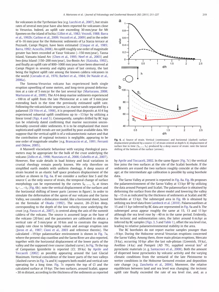
Uplift and subsidence of the Earth's surface are observed in manyvolcanic areas. The displacement pattern reveals such characteristicsas depth and rate of magma accumulation (e.g. Dvorak and Dzurisin,1997). In addition to rapid changes associated with individualeruptions, long-term changes occur in the shape of volcanoes. Strainrates of a fewmillimeters/year, comparable to tectonic ones estimatedin Southern Italy (1–2 mm/year; Luongo et al., 1991; Westaway,1993; Bordoni and Valensise, 1998; Amato and Cinque, 1999; Pataccaand Scandone, 2001; Ferranti and Oldow, 2005), have been calculated
Fig. 6. a) Source of strain. Vertical (continuous) and horizontal (dashed) surfacedisplacement produced by a source (C) of strain centred at depth h. b) displacement ofsurface line in time (S0 ,…, S5) produced by a deep source of strain: note the lateralshifting of the bottom of the surface (arrows).
219A. Marturano et al. / Journal of Volcanology and Geothermal Research 202 (2011) 211–227
for volcanoes in the Tyrrhenian Sea (e.g. Lucchi et al., 2007), but strainrates of several mm/year have also been reported for volcanoes closeto Vesuvius. Indeed, an uplift rate exceeding 30 mm/year for MtEpomeo on the island of Ischia (Gillot et al., 1982; Vezzoli, 1988; Barraet al., 1992b; Carlino et al., 2009; Vezzoli et al., 2009) and in the orderof 6–16 mm/year for the Holocenic sediments of La Starza terrace atPozzuoli, Campi Flegrei, have been estimated (Cinque et al., 1985;Barra, 1992; Acocella, 2008). An uplift roughly one order of magnitudegreater has been recorded at Yasur Volcano (~150 mm/year), TannaIsland, Vanuatu Island Arc (Chen et al., 1995; Neef et al., 2003) andIwo-Jima Island (150–200 mm/year), Izu-Bonin Arc (Kaizuka, 1992),and finally an uplift rate of 800–1000 mm/year have been observed atCampi Flegrei in seventy and eighty years of last century, the lastbeing the highest uplift rate among the known caldera volcanoes inthe world (Corrado et al., 1976; Barberi et al., 1984; De Natale et al.,2006a).
The Somma-Vesuvius volcano has experienced both singleeruption upwelling of some metres, and long-term ground deforma-tion at a rate of 5 mm/yr for the last several kyr (Marturano, 2008;Marturano et al., 2009). The A14 deep marine sediments experienced~100 m of uplift from the late Pleistocene at a rate of 5 mm/yearextending back in the time the previously estimated uplift rate.Following the volcaniclastic sequence, i.e. marine sands separated by apalaeosol (Di Vito et al., 1998), it is proposed that deposits at A14 logexperienced subaerial uplift conditions up to ~13 kyr by utilizing alinear trend (Figs. 4 and 5). Consequently, samples drilled by BC logscan be relatively dated confirming that marine succession uncon-formably covered older sediments. It is to be emphasized that moresophisticated uplift trends are not justified by poor available data. Wesuppose that the vertical uplift is of a volcanotectonic nature and thatthe contribution of regional tectonics is negligible, appearing to beone order of magnitude smaller (e.g. Brancaccio et al., 1991; Ferrantiand Oldow, 2005).
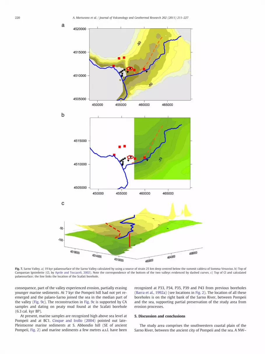
A Maxwell viscoelastic behaviour with varying rheological para-meters may be appropriate for the bulk of the crust underlying thevolcano (Zollo et al., 1998; Nunziata et al., 2006; Cubellis et al., 2007).However, fine scale details in load history and local variations incrustal rheology remain poorly known. We rely therefore onsimplified earth models with uniform rheology. A deep source ofstrain located in an elastic half space produces displacement of thesurface as shown in Fig. 6a. If we consider a surface line S and thesource C as the only source of strain, the temporal change of surfacemorphology can be represented by the curves S0 ,…, S5 at timest0b…b t5 (Fig. 6b): note the vertical displacement of the surfaces andthe horizontal shifting of lower parts (arrows in figure). In order tosimulate the deformation of the apron of our volcano and the SarnoValley, we consider a dislocation model, like a horizontal sheet, basedon the formulas of Okada (1992). The source, 20–25 km deep,corresponding to the depth of the low velocity zone underlying thecrust (e.g. Panza et al., 2007), is centred along the axis of the summitcaldera of the volcano. The source is assumed large as the base ofthe volcano (20 km) and the parameters are calibrated to obtain avertical rate of 5 mm/year at 10 km and to constrain the magmasupply rate close to bibliography values and average eruption rate(Joron et al., 1987; Cioni et al., 2003 and reference therein). Thecalculated ~19 kyr palaeosurface environment is shown in Fig. 7a,where the present-day coastline and the Sarno River are also reported,together with the horizontal displacement of the lower parts of thevalley and the supposed river course (dashed curve). In Fig. 7b the topof Campanian Ignimbrite is reported (CI; 39 ka) by Aprile andToccaceli (2002) as possibly appearing around the Last GlacialMaximum. Vertical coincidence of the lower parts of the two valleys(dashed curves in Fig. 7a and b) supports both model and vertical rateoperating for a long time. Fig. 7c reports the top of CI and thecalculated surface at 19 kyr. The two surfaces, around Scafati, appear~30 m distant, according to the thickness of the sediments as reported
by Aprile and Toccaceli, 2002. In the same figure (Fig. 7c) the verticalline joins the two surfaces at the site of the Scafati borehole. If thesediments are erased the two surfaces roughly coincide at the olderage; at the intermediate age calibration is possible by using boreholedata.
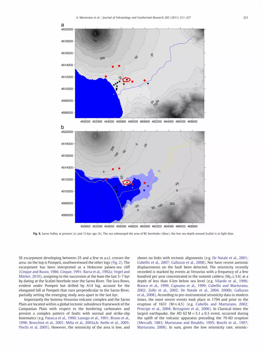
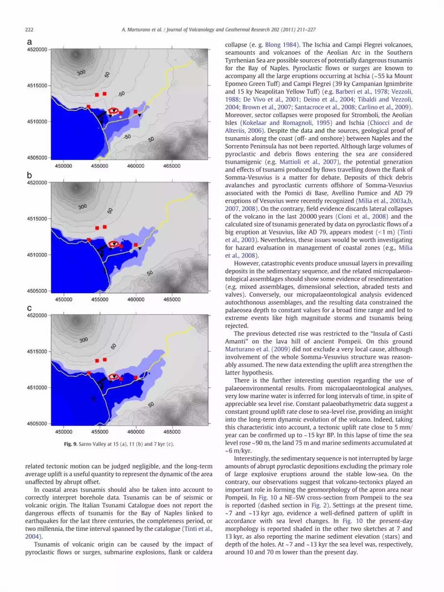
The Sarno Valley at present is reported in Fig. 8a. Fig. 8b proposesthe palaeoenvironment of the Sarno Valley at 13 kyr BP by utilizingthe data around Pompeii and Scafati. The palaeosurface is obtained bydeforming the surface from the above model and lowering the valleyby ~15 m as indicated by the thickness of sediments at Scafati and BCboreholes at 13 kyr. The submerged area in Fig. 8b is obtained byutilizing sea level data from Lambeck et al. (2010). Palaeocoastlines at15 and 11 kyr inferred by BC data are represented in Fig. 9a and b. Thesubmerged areas appear roughly the same at 15, 13 and 11 kyralthough the sea level rose by ~40 m in the same period. Evidently,the tectonic and sedimentation rates, the latter around 6 m/kyr asinferred by BC samples (Figs. 3, 5 and Table 1), offset the sea level rise,leading to relative palaeoenvironmental stability in the area.
The BC boreholes do not report marine samples younger than~9 kyr. During the Holocene several Vesuvian eruptions concernedthe Sarno Valley. Among them, three main plinian eruptions, Mercato(9 ka), occurring 10 kyr after the last sub-plinian (Greenish, 19 ka),Avellino (4 ka) and Pompeii (AD 79), supplied several km3 ofpyroclastic materials (e. g. Santacroce et al., 2008). Both the amountof dispersed loose pyroclastics by volcanic activity and the varyingclimatic conditions from the semiarid of the late Pleistocene towetter conditions in the Holocene favoured erosion and depositionrate change (e.g. Zanchetta et al., 2004). Moreover, the relativeequilibrium between land and sea level was changing: the tectonicuplift rate finally exceeded the rate of sea level rise, and, as a
Fig. 7. Sarno Valley. a) 19 kyr palaeosurface of the Sarno Valley calculated by using a source of strain 25 km deep centred below the summit caldera of Somma-Vesuvius. b) Top ofCampanian Ignimbrite (CI, by Aprile and Toccaceli, 2002). Note the correspondence of the bottom of the two valleys evidenced by dashed curves. c) Top of CI and calculatedpalaeosurface; the line links the location of the Scafati borehole.
220 A. Marturano et al. / Journal of Volcanology and Geothermal Research 202 (2011) 211–227
consequence, part of the valley experienced erosion, partially erasingyounger marine sediments. At 7 kyr the Pompeii hill had not yet re-emerged and the palaeo-Sarno joined the sea in the median part ofthe valley (Fig. 9c). The reconstruction in Fig. 9c is supported by CAsamples and dating on peaty mud found at the Scafati borehole(6.3 cal. kyr BP).
At present, marine samples are recognized high above sea level atPompeii and at BC1. Cinque and Irollo (2004) pointed out late-Pleistocene marine sediments at S. Abbondio hill (SE of ancientPompeii, Fig. 2) and marine sediments a few metres a.s.l. have been
recognized at P33, P34, P35, P39 and P43 from previous boreholes(Barra et al., 1992a) (see locations in Fig. 2). The location of all theseboreholes is on the right bank of the Sarno River, between Pompeiiand the sea, supporting partial preservation of the study area fromerosion processes.
5. Discussion and conclusions
The study area comprises the southwestern coastal plain of theSarno River, between the ancient city of Pompeii and the sea. A NW–
Fig. 8. Sarno Valley at present (a) and 13 kyr ago (b). The sea submerged the area of BC boreholes (blue); the low sea depth around Scafati is in light blue.
221A. Marturano et al. / Journal of Volcanology and Geothermal Research 202 (2011) 211–227
SE escarpment developing between 25 and a few m a.s.l. crosses thearea: on the top is Pompeii, southwestward the other logs (Fig. 2). Theescarpment has been interpreted as a Holocene palaeo-sea cliff(Cinque and Russo, 1986; Cinque, 1991; Barra et al., 1992a; Vogel andMärker, 2010), assigning to the succession at the base the last 5–7 kyrby dating at the Scafati borehole near the Sarno River. The lava flows,evident under Pompeii but drilled by A14 log, account for theelongated hill at Pompeii that runs perpendicular to the Sarno River,partially setting the emerging study area apart in the last kyr.
Importantly the Somma-Vesuvius volcanic complex and the SarnoPlain are located within a global tectonic subsidence framework of theCampanian Plain with respect to the bordering carbonates andpresent a complex pattern of faults with normal and strike-slipkinematics (e.g. Patacca et al., 1990; Luongo et al., 1991; Bruno et al.,1998; Brocchini et al., 2001; Milia et al., 2003a,b; Aiello et al., 2005;Piochi et al, 2005). However, the seismicity of the area is low, and
shows no links with tectonic alignments (e.g. De Natale et al., 2001;Cubellis et al., 2007; Galluzzo et al., 2008). Nor have recent aseismicdisplacements on the fault been detected. The seismicity recentlyrecorded is marked by events at Vesuvius with a frequency of a fewhundred per year concentrated in the summit caldera (MD≤3.6) at adepth of less than 6 km below sea level (e.g. Vilardo et al., 1996;Bianco et al., 1999; Capuano et al., 1999; Cubellis and Marturano,2002; Zollo et al., 2002; De Natale et al., 2004, 2006b; Galluzzoet al., 2008). According to pre-instrumental seismicity data in moderntimes, the most severe events took place in 1794 and prior to theeruption of 1631 (M≈4.5) (e.g. Cubellis and Marturano, 2002;Principe et al., 2004; Bertagnini et al., 2006). In Classical times thelargest earthquake, the AD 62 M=5.1±0.3 event, occurred duringthe uplift of the volcanic apparatus preceding the 79 AD eruption(Mercalli, 1883; Marturano and Rinaldis, 1995; Boschi et al., 1997;Marturano, 2008). In sum, given the low seismicity rate, seismic-
Fig. 9. Sarno Valley at 15 (a), 11 (b) and 7 kyr (c).
222 A. Marturano et al. / Journal of Volcanology and Geothermal Research 202 (2011) 211–227
related tectonic motion can be judged negligible, and the long-termaverage uplift is a useful quantity to represent the dynamic of the areaunaffected by abrupt offset.
In coastal areas tsunamis should also be taken into account tocorrectly interpret borehole data. Tsunamis can be of seismic orvolcanic origin. The Italian Tsunami Catalogue does not report thedangerous effects of tsunamis for the Bay of Naples linked toearthquakes for the last three centuries, the completeness period, ortwo millennia, the time interval spanned by the catalogue (Tinti et al.,2004).
Tsunamis of volcanic origin can be caused by the impact ofpyroclastic flows or surges, submarine explosions, flank or caldera
collapse (e. g. Blong 1984). The Ischia and Campi Flegrei volcanoes,seamounts and volcanoes of the Aeolian Arc in the SouthernTyrrhenian Sea are possible sources of potentially dangerous tsunamisfor the Bay of Naples. Pyroclastic flows or surges are known toaccompany all the large eruptions occurring at Ischia (~55 ka MountEpomeo Green Tuff) and Campi Flegrei (39 ky Campanian Ignimbriteand 15 ky Neapolitan Yellow Tuff) (e.g. Barberi et al., 1978; Vezzoli,1988; De Vivo et al., 2001; Deino et al., 2004; Tibaldi and Vezzoli,2004; Brown et al., 2007; Santacroce et al., 2008; Carlino et al., 2009).Moreover, sector collapses were proposed for Stromboli, the AeolianIsles (Kokelaar and Romagnoli, 1995) and Ischia (Chiocci and deAlteriis, 2006). Despite the data and the sources, geological proof oftsunamis along the coast (off- and onshore) between Naples and theSorrento Peninsula has not been reported. Although large volumes ofpyroclastic and debris flows entering the sea are consideredtsunamigenic (e.g. Mattioli et al., 2007), the potential generationand effects of tsunami produced by flows travelling down the flank ofSomma-Vesuvius is a matter for debate. Deposits of thick debrisavalanches and pyroclastic currents offshore of Somma-Vesuviusassociated with the Pomici di Base, Avellino Pumice and AD 79eruptions of Vesuvius were recently recognized (Milia et al., 2003a,b,2007, 2008). On the contrary, field evidence discards lateral collapsesof the volcano in the last 20000 years (Cioni et al., 2008) and thecalculated size of tsunamis generated by data on pyroclastic flows of abig eruption at Vesuvius, like AD 79, appears modest (b1 m) (Tintiet al., 2003). Nevertheless, these issues would be worth investigatingfor hazard evaluation in management of coastal zones (e.g., Miliaet al., 2008).
However, catastrophic events produce unusual layers in prevailingdeposits in the sedimentary sequence, and the related micropalaeon-tological assemblages should show some evidence of resedimentation(e.g. mixed assemblages, dimensional selection, abraded tests andvalves). Conversely, our micropalaeontological analysis evidencedautochthonous assemblages, and the resulting data constrained thepalaeosea depth to constant values for a broad time range and led toextreme events like high magnitude storms and tsunamis beingrejected.
The previous detected rise was restricted to the “Insula of CastiAmanti” on the lava hill of ancient Pompeii. On this groundMarturano et al. (2009) did not exclude a very local cause, althoughinvolvement of the whole Somma-Vesuvius structure was reason-ably assumed. The new data extending the uplift area strengthen thelatter hypothesis.
There is the further interesting question regarding the use ofpalaeoenvironmental results. From micropalaeontological analyses,very lowmarine water is inferred for long intervals of time, in spite ofappreciable sea level rise. Constant palaeobathymetric data suggest aconstant ground uplift rate close to sea-level rise, providing an insightinto the long-term dynamic evolution of the volcano. Indeed, takingthis characteristic into account, a tectonic uplift rate close to 5 mm/year can be confirmed up to ~15 kyr BP. In this lapse of time the sealevel rose ~90 m, the land 75 m andmarine sediments accumulated at~6 m/kyr.
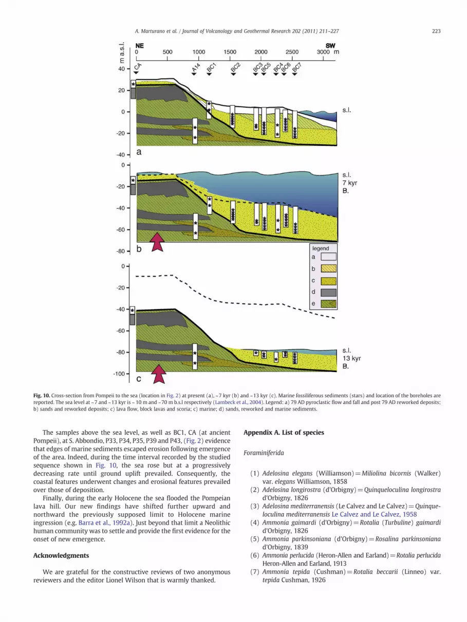
Interestingly, the sedimentary sequence is not interrupted by largeamounts of abrupt pyroclastic depositions excluding the primary roleof large explosive eruptions around the stable low-sea. On thecontrary, our observations suggest that volcano-tectonics played animportant role in forming the geomorphology of the apron area nearPompeii. In Fig. 10 a NE–SW cross-section from Pompeii to the seais reported (dashed section in Fig. 2). Settings at the present time,~7 and ~13 kyr ago, evidence a well-defined pattern of uplift inaccordance with sea level changes. In Fig. 10 the present-daymorphology is reported shaded in the other two sketches at 7 and13 kyr, as also reporting the marine sediment elevation (stars) anddepth of the holes. At ~7 and ~13 kyr the sea level was, respectively,around 10 and 70 m lower than the present day.
Fig. 10. Cross-section from Pompeii to the sea (location in Fig. 2) at present (a), ~7 kyr (b) and ~13 kyr (c). Marine fossiliferous sediments (stars) and location of the boreholes arereported. The sea level at ~7 and ~13 kyr is ~ 10 m and ~70 m b.s.l respectively (Lambeck et al., 2004). Legend: a) 79 AD pyroclastic flow and fall and post 79 AD reworked deposits;b) sands and reworked deposits; c) lava flow, block lavas and scoria; c) marine; d) sands, reworked and marine sediments.
223A. Marturano et al. / Journal of Volcanology and Geothermal Research 202 (2011) 211–227
The samples above the sea level, as well as BC1, CA (at ancientPompeii), at S. Abbondio, P33, P34, P35, P39 and P43, (Fig. 2) evidencethat edges of marine sediments escaped erosion following emergenceof the area. Indeed, during the time interval recorded by the studiedsequence shown in Fig. 10, the sea rose but at a progressivelydecreasing rate until ground uplift prevailed. Consequently, thecoastal features underwent changes and erosional features prevailedover those of deposition.
Finally, during the early Holocene the sea flooded the Pompeianlava hill. Our new findings have shifted further upward andnorthward the previously supposed limit to Holocene marineingression (e.g. Barra et al., 1992a). Just beyond that limit a Neolithichuman community was to settle and provide the first evidence for theonset of new emergence.
Acknowledgments
We are grateful for the constructive reviews of two anonymousreviewers and the editor Lionel Wilson that is warmly thanked.
Acocella, V., 2008. Activating and reactivating pairs of nested collapses during calderaforming eruptions: Campi Flegrei (Italy). Geophys. Res. Lett. 35, L17304.doi:10.1029/2008GL035078.
Acocella, V., Funiciello, R., 2006. Transverse systems along the extensional Tyrrhenianmargin of central Italy and their influence on volcanism. Tectonics 25, TC2003.doi:10.1029/2005TC001845.
Aiello, G., Angelino, A., D'Argenio, B., Marsella, E., Pelosi, N., Ruggieri, S., Siniscalchi, A.,2005. Buried volcanic structures in the Gulf of Naples (Souther Tyrrhenian Sea,Italy) resulting from high resolution magnetic survey and seismic profiling. Ann.Geophys. 48 (6), 883–897.
Aiello, G., Barra, D., Coppa, M.G., Valente, A., Zeni, F., 2006. Recent infralittoralForaminiferida and Ostracoda from the Porto Cesareo Lagoon (Ionian Sea,Mediterranean). Boll. Soc. Paleontologica Ital. 45 (1), 1–14.
Albore Livadie, C., Barra, D., Bonaduce, G., Brancaccio, L., Cinque, A., Ortolani, F., Pagliuca,S., Russo, F., 1991. Evoluzione geomorfologica, neotettonica e vulcanica della pianacostiera del fiume Sarno (Campania) in relazione agli insediamenti anterioriall'eruzione del 79 d.C. PACT. Vulcanismo, Paleogeografia e Archeologia. CentroUniv. Beni Culturali Ravello, pp. 237–256.
Amato, A., Cinque, A., 1999. Erosional landsurfaces of the Campano-Lucano Apennines(S. Italy): genesis, evolution, and tectonic implications. Tectonophysics 315,251–267.
Antonioli, F., Ferranti, L., Fontana, A., Amorosi, A., Bondesan, A., Braitenberg, C., Dutton,A., Fontolan, G., Furlani, S., Lambeck, K., Mastronuzzi, G., Monaco, C., Spada, G.,Stocchi, P., 2009. Holocene relative sea-level changes and vertical movementsalong the Italian and Istrian coastlines. Quatern. Int. 206, 102–133. doi:10.1016/j.quaint.2008.11.008.
Aprile, F., Toccaceli, R.M., 2002. Nuove conoscenze sulla stratigrafia e distribuzione deidepositi ignimbritici quaternari nel sottosuolo della Piana del Sarno (Salerno,Campania) – Italia Meridionale. Quaternario 15, 169–174.
Arbulla, D., Pugliese, N., Russo, A., 2001. Ostracodi del Golfo Saline (Sardegna nord-orientale). Studi Trentini Sci. Nat. Acta Geol. 77, 25–35.
Arbulla, D., Pugliese, N., Russo, A., 2004. Ostracods from the National Park of LaMaddalenaArchipelago (Sardinia, Italy). Boll. Soc. Paleontologica Ital. 43 (1–2), 91–99.
Barbeito-Gonzalez, P.J., 1971. Die Ostracoden des Küstenbereiches von Naxos(Griechenland) und ihre Lebensbereiche. Mitt. hamburgischen zoologischenMus. Inst. 67, 255–326 47 pls.
Barberi, F., Innocenti, F., Lirer, L., Munno, R., Pescatore, T.S., Santacroce, R., 1978. TheCampanian Ignimbrite: a major prehistoric eruption in the Neapolitan area (Italy).Bull. Volcanol. 41, 10–22.
The 1982–1984 Bradyseismic crisis at Phlegrean Fields (Italy). In: Barberi, F., Hill, D.P.,Innocenti, F., Luongo, G., Treuil, M. (Eds.), Bull. Volcanol, 47, pp. 173–411.
Barra, D., 1992. Studio del Pleistocene superiore-Olocene delle aree vulcanichecampane. In: De Frede (Ed.), Tesi di Dottorato di Ricerca in “Geologiadel Sedimentario”. Università degli Studi di Napoli “Federico II”, Napoli. 298 pp,9 pls.
Barra, D., Bonaduce, G., Brancaccio, L., Cinque, A., Ortolani, F., Pagliuca, S., Russo, F., 1989.Evoluzione geologica olocenica della piana costiera del Fiume Sarno (Campania).Mem. Soc. Geol. Ital. 42, 255–267.
Barra, D., Bonaduce, G., Brancaccio, L., Cinque, A., Ortolani, F., Pagliuca, S., Russo, F.,1992a. Evoluzione geologica olocenica della piana costiera del Fiume Sarno(Campania). Mem. Soc. Geol. Ital. 42, 255–267.
Barra, D., Cinque, A., Italiano, A., Scorziello, R., 1992b. Il Pleistocene superiore marino diIschia: paleoecologia e rapporti con l'evoluzione tettonica recente. Studi Geol.Camerti 1992/1, 231–243.
Bertagnini, A., Cioni, R., Guidoboni, E., Rosi, M., Neri, A., Boschi, E., 2006. Eruptionearly warning at Vesuvius: The A.D. 1631 lesson. Geophys. Res. Lett. 33, L18317.doi:10.1029/2006GL027297.
Bianco, F., Castellano, M., Milano, G., Vilardo, G., Ferrucci, F., Gresta, S., 1999. The seismiccrises at Mt.Vesuvius during 1995 and 1996. Phys. Chem. Earth A Solid Earth Geod.24 (11–12), 977–983.
Blanc-Vernet, L., 1969. Contribution à l'étude des foraminifères de Méditerranée.Relations entre la microfaune et les sédiments; biocoenoses actuelles, thanatocoe-noses Pliocènes et Quaternaires, 64. Recueil des travaux de la Station Marined'Endoume, Marseille. 281 pp.
Blanc-Vernet, L., Clairefond, P., Orsolini, P., 1979. Les foraminifères. In: Burollet, P.F.,Clairefond, P., Winnock, E. (Eds.), La mer Pélagienne: Géologie Méditerranée, 6 (1),pp. 171–209.
Blong, R.J., 1984. Volcanic Hazards. Academic Press. 424 pp.Bonaduce, G., Ciampo, G., Masoli, M., 1976. Distribution of Ostracoda in the Adriatic Sea.
Pubbl. Stn. Zool. Napoli 40 (supplemento 1), 1–304.Bonaduce, G., Masoli, M., Pugliese, N., 1977. Ostracodi bentonici dell'alto Tirreno. Studi
Trentini Sci. Nat. Biol. 54, 243–261.Bonaduce, G., Masoli, M., Pugliese, N., 1988. Remarks on the Benthic Ostracoda on the
Tunisian Shelf. In: Hanai, T., Ikeya, N., Ishizaki, K. (Eds.), Evolutionary biology ofOstracoda its fundamentals and applications. Proceedings of the Ninth Interna-tional Symposium on Ostracoda, held in Shizuoka, Japan 29 July-2 August 1985:Developments in Palaeontology and Stratigraphy, 11, pp. 449–466.
Bordoni, P., Valensise, G., 1998. Deformation of the 125 ka marine terrace in Italy:tectonic implications. In: Stewart, I.S., Vita Finzi, C. (Eds.), Late Quaternary CoastalTectonics, 146. Geol. Soc. Lond., London, pp. 71–110.
Boschi, E., Guidoboni, E., Ferrari, G., Valensise, G., Gasparini, P., 1997. Catalogo dei FortiTerremoti in Italia dal 461 A.D. al 1990. ING-SGA.
Brancaccio, L., Cinque, A., Romano, P., Rosskopf, C., Russo, F., Santangelo, N., Santo, A.,1991. Geomorphology and neotectonic evolution of a sector of the Tyrrhenian andof the Southern Apennines (Region of Naples, Italy). Z. Geomorph. N F 82, 47–58.
Breman, E., 1976. The Distribution of Ostracodes in the Bottom Sediments of the AdriaticSea Academisch Proefschrift. 165 pp. Vrije Universiteit te Amsterdam, Amsterdam.
Brocchini, D., Principe, C., Castradori, D., Laurenzi, M.A., Gorla, L., 2001. Quaternaryevolution of the southern sector of the Campanian Plain and early Somma-Vesuviusactivity: insights from the Trecase 1 well. Mineral. Petrol. 73, 67–91.
Brown, R.J., Orsi, G., de Vita, S., 2007. New insights into Late Pleistocene explosivevolcanic activity and caldera formation on Ischia (southern Italy). Bull. Volcanol.doi:10.1007/s00445-007-0155-0.
Bruno, P.P.G., Cippitelli, G., Rapolla, A., 1998. Seismic study of the Mesozoic carbonatebasement around Mt. Somma-Vesuvius, Italy. J. Volcanol. Geotherm. Res. 84,311–322.
Capuano, P., Coppa, U., De Natale, G., Di Sena, F., Godano, C., Troise, C., 1999. A detailedanalysis of some local earthquakes at Somma-Vesuvius. Ann. Geophys. 42 (3),391–406.
Carlino, S., Cubellis, E., Luongo, G., Obrizzo, F., 2009. On the mechanics of calderaresurgence of Ischia Island (southern Italy). In: Troise, C., De Natale, G., Kilburn, C.(Eds.), Mechanisms of activity and unrest at large Calderas. Geological Society,London, pp. 181–193. Special Publications, 269.
Chen, J.H., Taylor, F.W., Edwards, R.L., Cheng, H., Burr, G.S., 1995. Recent emerged reefterraces of the Yenkahe resurgent block, Tanna, Vanuatu: implications for volcanic,landslide and tsunami hazards. J. Geol. 103, 577–590.
Chiocci, F.L., de Alteriis, G., 2006. The Ischia debris avalanche. First, clear submarineevidence in the Mediterranean of a volcanic island pre-historic collapse. Terra Nova18, 202–209.
Ciarallo, A., Pescatore, T., Senatore, M.R., 2003. Su un antico corso d'acqua a nord diPompeii. Riv. Studi Pompeiani 14, 273–283.
Cinque, A., 1991. La trasgressione Versiliana nella piana del Sarno (Campania). Geogr.Fis. Dinam. Quat. 14, 63–71.
Cinque, A., Irollo, G., 2004. Il “Vulcano di Pompei”: nuovi dati geomorfologici estratigrafici. Quaternario 17, 101–116.
Cinque, A., Russo, F., 1986. La linea di costa del 79 d. C. fra Oplonti e Stabiae nel quadrodell'evoluzione olocenica della Piana del Sarno (Campania). Boll. Soc. Geol. Ital. 105,111–121.
Cinque, A., Rolandi, G., Zamparelli, V., 1985. L'estensione dei depositi marini olocenicinei Campi Flegrei in relazione alla vulcano-tettonica. Bull. Soc. Geol. Ital. 104,327–348.
Cinque, A., Patacca, E., Scandone, P., Tozzi, M., 1993. Quaternary kinematic evolution ofthe Southern Appenines. Relationships between surface geological features anddeep lithospheric structures. Ann. Geofis. 36 (2), 249–259.
Cioni, R., Longo, A., Macedonio, G., Santacroce, R., Sbrana, A., Sulpizio, R., Andronico, D.,2003. Assessing pyroclastic fall hazard through field data and numericalsimulations: example from Vesuvius. J. Geophys. Res. 108 (B2). doi:10.1029/2001JB000642.
Cioni, R., Bertagnini, A., Santacroce, R., Andronico, D., 2008. Explosive activity anderuption scenarios at Somma-Vesuvius (Italy): toward a new classification scheme.J. Volcanol. Geotherm. Res. 178, 331–346. doi:10.1016/j.jvolgeores.2008.04.024.
Corrado, G., Guerra, I., Lo Bascio, A., Luongo, G., Rampoldi, R., 1976. Inflation andmicroearthquake activity of Phlegraean Fields, Italy. Bull. Volcanol. 40 (3), 169–188.
Cubellis, E., Marturano, A., 2002. Mt. Vesuvius: a macroseismic study of the earthquakeof October 9, 1999. J. Volcanol. Geotherm. Res. 118, 339–351.
Cubellis, E., Luongo, G., Marturano, A., 2007. Seismic hazard assessment at mountVesuvius: maximum magnitude expected. J. Volcanol. Geotherm. Res. 162,139–148. doi:10.1016/j.jvolgeores.2007.03.003.
De Natale, G., Troise, C., Pingue, F., De Gori, P., Chiarabba, C., 2001. Structure anddynamics of Somma-Vesuvius volcanic complex. Mineral. Petrol. 73, 5–22.
De Natale, G., Kuznetzov, I., Kronrod, T., Peresan, A., Saraò, A., Troise, C., Panza, G.F.,2004. Three decades of seismic activity at Mt. Vesuvius: 1972–1999. Pure Appl.Geophys. 161, 123–144.
226 A. Marturano et al. / Journal of Volcanology and Geothermal Research 202 (2011) 211–227
De Natale, G., Troise, C., Pingue, F., Mastrolorenzo, G., Pappalardo, L., Boschi, E., 2006a.The Campi Flegrei caldera: unrest mechanisms and hazards. In: Troise, C., DeNatale, G., Kilburn, C.R.J. (Eds.), Mechanisms of Activity and Unrest at LargeCalderas: Geol. Soc. London Spec. Publ, 269, pp. 25–45.
De Vivo, B., Rolandi, G., Gans, P.B., Calvert, A., Bohrson, W.A., Spera, J.F., Belkin, H.E.,2001. New constraints on the pyroclastic eruptive history of the Campanianvolcanic Plain(Italy). Mineral. Petrol. 73, 47–65.
Deino, A.L., Orsi, G., de Vita, S., Piochi, M., 2004. The age of the Neapolitan Yellow Tuffcaldera-forming eruption (Campi Flegrei caldera Italy) assessed by Ar-41/Ar-39dating method. J. Volcanol. Geotherm. Res. 133 (1–4), 137–170.
Delibrias, G., Di Paola, G.M., Rosi, M., Santacroce, R., 1979. La storia eruttiva delcomplesso vulcanico Somma Vesuvio ricostruita dalle successioni piroclastiche delMonte Somma. Rend. Soc. Ital. Mineral. Petrol. 35, 411–438.
Di Renzo, M., Di Vito, M.A., Arienzo, I., Carandente, A., Civetta, L., D'Antonio, M.,Giordano, F., Orsi, G., Tonarini, S., 2007. Magmatic history of Somma-Vesuvius onthe basis of new geochemical and isotopic data from a deep borehole (Camaldolidella Torre). J. Petrol. 48, 753–784.
Di Vito, M., Sulpizio, R., Zanchetta, G., Calderoni, G., 1998. The geology of the SouthWestern Slopes of Somma-Vesuvius, Italy as inferred by borehole stratigraphiesand cores. Acta Vulcanol. 10 (2), 383–393.
Donnici, S., Serandrei Barbero, R., 2002. The benthic foraminiferal communities of thenorthern Adriatic continental shelf. Mar. Micropaleontol. 44, 93–123.
Dvorak, J., Dzurisin, D., 1997. Volcano Geodesy: the search formagma reservoirs and theformation of eruptive vents. Rev. Geophys. 35, 343–384.
Ferranti, L., Oldow, J.S., 2005. Latest Miocene to Quaternary horizontal and verticaldisplacement rates during simultaneous contraction and extension in the SouthernApennine orogen, Italy. Terra Nova 17, 209–214.
Ferranti, L., Antonioli, F., Mauz, B., Amorosi, A., Dai Prà, G., Mastronuzzi, G., Monaco, C.,Orrù, P., Pappalardo, M., Radtke, U., Renda, P., Romano, P., Sansò, P., Verrubbi, V.,2006. Markers of the last interglacial sea-level high stand along the coast of Italy:tectonic implications. Quatern. Int. 145–146, 30–54.
Frezza, V., Carboni, M.G., 2009. Distribution of recent foraminiferal assemblages nearthe Ombrone River mouth (Northern Tyrrhenian Sea, Italy). Rev. Micropaléontol.52, 43–66.
Galluzzo, D., Zonno, G., Del Pezzo, E., 2008. Stochastic finite-fault ground-motionsimulation in a wave-field diffusive regime: case study of the Mt. Vesuvius volcanicarea. Bull. Seism. Soc. Am. 98, 1272–1288. doi:10.1785/0120070183.
Gillot, P.-Y., Chiesa, S., Pasquare, G., Vezzoli, L., 1982. b33,000-yr K–Ar dating of thevolcano-tectonic horst of the Isle of Ischia, Gulf of Naples. Nature 299, 242–245.
Haake, F.W., 1977. Living benthic Foraminifera in the Adriatic Sea; influence of waterdepth and sediment. J. Foramin. Res. 7 (1), 62–75.
Jorissen, F.J., 1987. The distribution of benthic foraminifera in the Adriatic Sea. Mar.Micropaleontol. 12, 21–48.
Jorissen, F.J., 1988. Benthic foraminifera from the Adriatic Sea; principles of phenotypicvariations. Utrech Micropal. Bull. 37 174 pp.
Joron, J.L., Metrich, N., Rosi, M., Santacroce, R., Sbrana, A., 1987. Chemistry andpetrography. In: Santacroce, R. (Ed.), Somma-Vesuvius. C.N.R. : Quaderni de 'LaRicerca Scientifica, 114, pp. 105–174. Rome.
Kaizuka, S., 1992. Coastal evolution at a rapidly uplifting volcanic island: Iwo-Jima,Western Pacific Ocean. Quatern. Int. 15/16, 7–16.
Kokelaar, P., Romagnoli, C., 1995. Sector collapse, sedimentation and clast populationevolution at an active island-arcvolcano: Stromboli, Italy. Bull. Volcanol. 57,240–262.
Lambeck, K., Purcell, A., 2005. Sea-level change in theMediterranean Sea since the LGM:model predictions for tectonically stable areas. Quat. Sci. Rev. 24, 1969–1988.
Lambeck, K., Antonioli, F., Purcell, A., Silenzi, S., 2004. Sea-level change along the Italiancoast for the past 10,000 yr. Quat. Sci. Rev. 23, 1567–1598.
Lambeck, K., Antonioli, F., Anzidei, M., Ferranti, L., Leoni, G., Scicchitano, G., Silenzi, S.,2010. Sea level change along the italian coast during the Holocene and projectionsfor the future. Quatern. Int. doi:10.1016/j.quaint.2010.04.026.
Le Calvez, J., Le Calvez, Y., 1958. Répartition des foraminifères dans la baie deVillefranche. 1-Miliolidae. Ann. Institut Océanogr. 35, 159–234.
Lucchi, F., Tranne, C.A., Calanchi, N., Rossi, P.L., 2007. Late Quaternary deformationhistory of the volcanic edifice of Panarea, Aeolian Arc, Italy. Bull. Volcanol. 69,239–257. doi:10.1007/s00445-006-0070-9.
Luongo,G., Cubellis, E., Obrizzo, F., Petrazzuoli, S.M., 1991.Aphysicalmodel for the origin ofvolcanism of the Tyrrhenian margin: the case of Neapolitan area. In: Luongo, G.,Scandone, R. (Eds.), Campi Flegrei: J. Volcanol. Geotherm. Res., 48, pp. 173–185.
Marturano, A., 2008. Sources of ground movement at Vesuvius before the AD 79eruption: evidence from contemporary accounts and archaeological studies.J. Volcanol. Geotherm. Res. 177, 959–970. doi:10.1016/j.jvolgeores.2008.07.017.
Marturano, A., Rinaldis, V., 1995. Il terremoto del 62 d.C: un evento carico diresponsabilita'. In: Dtsch. Arch. Inst. Rom. Sopr. Arch. Pompei Oss. Vesuviano (eds.),Archaologie und Seismologie -La Regione Vesuviana dal 62 al 79 D.C. ProblemiArcheologici e Sismologici. Biering and Brinkmann, Munich, pp. 131–135
Marturano, A., Aiello, G., Barra, D., Fedele, L., Grifa, C., Morra, V., Berg, R., Varone, A.,2009. Evidence for Holocenic uplift at Somma-Vesuvius. J. Volcanol. Geotherm. Res.184, 451–461.
Mattioli, G.S., Voight, B., et al., 2007. Unique and remarkable dilatometer measurementsof pyroclastic flow-generated tsunamis. Geology 35, 25–28. doi:10.1130/G22931A.1.
Mele, D., Sulpizio, R., Dellino, P., La Volpe, L., 2010. Stratigraphy and eruptive dynamicsof a pulsating Plinian eruption of Somma-Vesuvius: the Pomici di Mercato(8900 years B.P.). Bull. Volcanol. doi:10.1007/s00445-010-0407-2.
Mercalli, G., 1883. Vulcani e fenomeni vulcanici in Italia. Rist. Anast. Forni, 1981.Milia, A., Torrente, M.M., Russo, M., Zuppetta, A., 2003a. Tectonics and crustal structure
of the Campania continental margin: relationships with volcanism. Mineral. Petrol.79, 33–47.
Milia, A., Torrente, M.M., Zuppetta, A., 2003b. Debris avalanches off shore of SommaVesuvius volcano, Italy: implications for volcanic hazard evaluation. J. Geol. Soc.Lond. 160, 309–317.
Milia, A., Raspini, A., Torrente, M.M., 2007. The dark nature of Somma-Vesuviusvolcano: evidence from the 3.5 ka B.P Avellino eruption. Quatern. Int. doi:10.1016/jquaint.2007.03.001.
Milia, A., Raspini, A., Torrente, M.M., 2008. The dark nature of Somma-Vesuviusvolcano: evidence from the 3.5 ka BP Avellino eruption — Reply. Quatern. Int. 192,110–115.
Müller, G.W., 1894. Die Ostracoden des Golfes von Neapel und der angrenzendenMeeres-Abschnitte. Fauna und Flora des Golfes von Neapel und der angrenzendenMeeres-Abschnitte, 21 (1–8). Zoologischen Station zu Neapel, pp. 1–404. pl. 40.
Neef, G., Zhao, J.X., Collerson, K.D., Zhang, F.S., 2003. Late Quaternary uplift andsubsidence of the west coast of Tanna, south Vanuatu, southwest Pacific: U-Th agesof raised coral reef in the Median Sedimentary Basin. Aust. J. Earth Sci. 50, 39–48.
Nunziata, C., Natale, M., Luongo, G., Panza, F.G., 2006. Magma reservoir at Mt. Vesuvius:size of the hot, partially molten, crust material detected deeper than 8 km. EarthPlanet. Sci. Lett. 242, 51–57.
Okada, Y., 1992. Internal deformation due to shear and tensile faults in a half-space.Bull. Seism. Soc. Am. 82, 1018–1040.
Panza, G.P., Peccerillo, A., Aoudia, A., Farina, B., 2007. Geophysical and petrologicalmodelling of the structure and composition of the crust and upper mantle incomplex geodynamic settings: the Tyrrhenian Sea and surroundings. Earth Sci. Rev.80, 1–46.
Patacca, E., Scandone, P., 2001. Late thrust propagation and sedimentary responsein the thrust-belt-foredeep system of the Southern Apennines (Pliocene–Pleistocene). In: Vai, G.B., Martini, I.P. (Eds.), Anatomy of an Orogen: the Apenninesand Adjacent Mediterranean Basins. Kluwer Academic Publishers, Great Britain,pp. 401–440.
Patacca, E., Sartori, R., Scandone, P., 1990. Tyrrhenian basin and apenninic arcs:kinematic relations since late Tortonian times. Mem. Soc. Geol. Ital. 45, 425–451.
Pescatore, T., Senatore, M.R., Capretto, G., Lerro, G., Patricelli, G., 1999. Ricostruzionepaleogeografica delle aree circostanti l'antica città di Pompei (Campania, Italia) altempo dell'eruzione del Vesuvio del 79 d.C. Boll. Soc. Geol. Ital. 118, 243–254.
Pescatore, T., Senatore, M.R., Capretto, G., Lerro, G., 2001. Holocene coast environe-ments near Pompeii before the A.D. 79 eruption of Mount Vesuvius, Italy. Quatern.Res. 55, 77–85. doi:10.1006/qres.2000.2186.
Peypouquet, J.P., Nachite, D., 1984. Les Ostracodes en Méditerranée nord-occidentale.Ecomed., Ass. Franc. Techn. Petròle, Paris, pp. 151–169.
Piochi, M., Bruno, P.P., De Astis, G., 2005. Relative roles of rifting tectonics and magmaascent processes: Inferences from geophysical, structural volcanological andgeochemical data for the Neapolitan volcanic region (southern Italy). Geochem.Geophys. Geosyst. 6, Q07005. doi:10.1029/ 2004GC000885.
Pirazzoli, P.A., 2005. A review of possible eustatic, isostatic, and tectonic contribution ineight Late-Holocene relative sea-level histories from the Mediterranean area. Quat.Sci. Rev. 24, 1989–2001.
Principe, C., Tanguy, J.C., Arrighi, S., Paliotti, A., Le Goff, M., Zoppi, U., 2004. Chronologyof Vesuvius' activity from A.D. 79 to 1631 based on archeomagnetism of lavas andhistorical sources. Bull. Volcanol. 66, 703–724.
Pujos, M., 1976. Ecologie des foraminifères benthiques et des thé-camoebiens de laGironde et au plateau continental Sud-Gascogne: application à la connaissance duQuaternaire terminal de la région Ouest-Gironde. Mem. Inst. Géol. Bassin Aquitaine8, 1–274.
Reimer, P.G., Baillie, M.G.L., Bard, E., Bayliss, A., Beck, J.W., Bertrand, C.J.H., Blackwell,P.G., Buck, C.E., Burr, G.S., Cutler, K.B., Damon, P.E., Edwards, R.L., Fairbanks, R.G.,Friedrich, M., Guilderson, T.P., Hogg, A.G., Hughen, K.A., Kromer, B., McCormac, G.,Manning, S., Ramsey, C.B., Reimer, R.W., Remmele, S., Southon, J.R., Stuiver, M.,Talamo, S., Taylor, F.W., van der Plicht, J., Weyhenmeyer, C.E., 2004. IntCal04terrestrial radiocarbon age calibration 0–26 cal kyr BP. Radiocarbon 46 (3),1029–1058.
Rolandi, G., Maraffi, S., Petrosino, P., Lirer, L., 1993. The Ottaviano eruption of Somma-Vesuvius (8000 years BP): a magmatic alternating fall and flow-forming eruption.J. Volcanol. Geotherm. Res. 58, 43–65.
Rome, D.R., 1964. Ostracodes des environs de Monaco, leur distribution en profondeur,nature des fonds marins explorés. Ostracods as ecological and palaeoecologicalindicators. Simposio intenazionale sotto gli auspici della Fondazione Antonio eRinaldo Dohrn presso la Stazione Zoologica di Napoli, 10–19 Giugno 1963, 33.Pubblicazioni della Stazione Zoologica di Napoli, pp. 200–212 (Supplemento).
Sacchi, M., Insinga, D., Milia, A., Molosso, F., Raspini, A., Torrente, M.M., Conforti, A.,2005. Stratigraphic signature of the Vesuvius 79 AD event off the Sarno prodeltasystem, Naples Bay. In: Trincardi, F., Syvitski, J. (Eds.), Mediterranean ProdeltaSystems: Marine Geology, 222–223, pp. 443–469.
Santacroce, R., Sbrana, A., 2003. Geological map of Vesuvius, S.E.L.C.A ed., Firenze.Santacroce, R., Cioni, R.,Marianelli, P., Sbrana, A., Sulpizio, R., Zanchetta, G., Donahue, D.J.,
Joron, J.L., 2008. Age and whole rock–glass compositions of proximal pyroclasticsfrom the major explosive eruptions of Somma-Vesuvius: a review as a tool fordistal tephrostratigraphy. J. Volcanol. Geotherm. Res. 177, 1–18. doi:10.1016/j.jvolgeores.2008.06.009.
Sgarrella, F., Barra, D., 1985. Distribuzione dei Foraminiferi bentonici nel Golfo diSalerno (Basso Tirreno, Italia). Boll. Soc. Nat. Napoli 93, 1–58.
Sgarrella, F., Moncharmont Zei, M., 1993. Benthic Foraminifera of the Gulf of Naples(Italy): systematics and autoecology. Boll. Soc. Paleontologica Ital. 32 (2), 145–264.
227A. Marturano et al. / Journal of Volcanology and Geothermal Research 202 (2011) 211–227
Sgarrella, F., Barra, D., Improta, A., 1985. The benthic foraminifers of the Gulf ofPolicastro (Southern Tyrrhenian Sea, Italy). Boll. Soc. Nat. Napoli 92, 67–114.
Stocchi, P., Spada, G., 2008. Glacio and hydro-isostasy in the Mediterranean Sea: Clark'szones and role of remote ice sheets. Ann. Geophys. 50 (6), 741–761.
Tibaldi, A., Vezzoli, L., 2004. A new type of volcano flank failure: the resurgent calderasector collapse, Ischia, Italy. Geophys. Res. Lett. 31, L14605. doi:10.1029/2004GL020419.
Tinti, S., Pagnoni, G., Piatanesi, A., 2003. Simulation of tsunamis induced by volcanicactivity in the Gulf of Naples (Italy). Nat. Hazards Earth Syst. Sci. 3, 311–320.
Tinti, S., Maramai, A., Graziani, L., 2004. The new catalogue of Italian tsunamis. Nat.Hazards 33, 439–465.
Triantaphyllou, M.V., Tsourou, T., Koukousioura, O., Dermitzakis, M.C., 2005. Forami-niferal and ostracod ecological patterns in coastal environments of SE Andros Island(Middle Aegean Sea, Greece). Rev. Micropaléontol. 48 (4), 279–302.
Uffenorde, H., 1972. Oekologie und jahreszeitliche Verteilung rezenter bentonischerOstracoden des Limski Kanal bei Rovinj (nördliche Adria). Göttinger Arb. Geol.Paläontol. 13, 1–121.
Vénec-Peyré, M.T., 1984. Ecologie des foraminifères en Méditerranée nord-occidentale.N. Etude de la distribution des foraminifères vivant dans la baie de Banyuls-sur-Mer. Ecologie des microorganismes en Méditerranée occidentale. Ecomed. A.F.T.P, Paris, pp. 60–80.
Vezzoli, L., 1988. Island of Ischia. Quaderni de La Ricerca Scientifica, 114 (10). ConsiglioNazionale delle Ricerche, Roma. 126 pp.
Vezzoli, L., Principe, C., Malfatti, J., Arrighi, S., Tanguy, J., Le Goff, M., 2009.Modes and timesof caldera resurgence: the b10 ka evolution of Ischia Caldera, Italy, from high-precision archaeomagnetic dating. J. Volcanol. Geotherm. Res. 186, 305–319.
Vilardo, G., De Natale, G., Milano, G., Coppa, U., 1996. The seismicity of Mt. Vesuvius.Tectonophysics 261, 127–138.
Vogel, S., Märker, M., 2010. Reconstructing the Roman topography and environmentalfeatures of the Sarno River Plain (Italy) before the AD 79 eruption of Somma-Vesuvius. Geomorphology 2010, 67–77. doi:10.1016/j.geomorph.2009.09.031.
Walker, G.P.L., 1977. Metodi geologici per la valutazione del rischio vulcanico. Attidel convegno: I vulcani attivi dell'areanapoletana. RegioneCampania,Napoli, pp. 53–60.
Westaway, R., 1993. Quaternary uplift of Southern Italy. J. Geophys. Res. 98, 741–772.Yassini, I., 1979. The littoral system Ostracodes from the bay of Bou-Ismail, Algiers,
Algeria. Rev. Esp. Micropaleontol. 11 (3), 353–416.Zanchetta, G., Sulpizio, R., Di Vito, M.A., 2004. The role of volcanic activity and climate in
alluvial fan growth at volcanic areas: an example from southern Campania (Italy).Sed. Geol. 168, 249–280.
Zollo, A., Gasparini, P., Virieux, J., Biella, G., Boschi, E., Capuano, P., de Franco, R.,Dell'Aversana, P., DeMatteis, R., De Natale, G., Iannaccone, G., Guerra, I., Le Meur, H.,Mirabile, L., 1998. An image of Mt. Vesuvius obtained by 2D seismic tomography.J. Volcanol. Geotherm. Res. 82, 161–173.
Zollo, A., Marzocchi, W., Capuano, P., Lomax, A., Iannaccone, G., 2002. Space timebehavior of seismic activity at Mt. Vesuvius Volcano, Southern Italy. Bull. Seismol.Soc. Am. 92, 625–640.