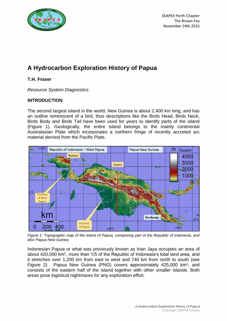
SEAPEX Perth Chapter The Brown Fox November 24th 2015 A Hydrocarbon Exploration History of Papua Copyright SEAPEX Society A Hydrocarbon Exploration History of Papua T.H. Fraser Resource System Diagnostics INTRODUCTION The second largest island in the world, New Guinea is about 2,400 km long, and has an outline reminiscent of a bird, thus descriptions like the Birds Head, Birds Neck, Birds Body and Birds Tail have been used for years to identify parts of the island (Figure 1). Geologically, the entire island belongs to the mainly continental Australasian Plate which incorporates a northern fringe of recently accreted arc material derived from the Pacific Plate. Figure 1: Topographic map of the island of Papua, comprising part of the Republic of Indonesia, and also Papua New Guinea Indonesian Papua or what was previously known as Irian Jaya occupies an area of about 420,000 km 2 , more than 1/5 of the Republic of Indonesia‟s total land area, and it stretches over 1,200 km from east to west and 740 km from north to south (see Figure 2). Papua New Guinea (PNG) covers approximately 425,000 km 2 , and consists of the eastern half of the island together with other smaller islands. Both areas pose logistical nightmares for any exploration effort.
Transcript
SEAPEX Perth ChapterThe Brown Fox
November 24th 2015
A Hydrocarbon Exploration History of Papua
Copyright SEAPEX Society
A Hydrocarbon Exploration History of Papua
T.H. Fraser
Resource System Diagnostics
INTRODUCTION
The second largest island in the world, New Guinea is about 2,400 km long, and has an outline reminiscent of a bird, thus descriptions like the Birds Head, Birds Neck, Birds Body and Birds Tail have been used for years to identify parts of the island (Figure 1). Geologically, the entire island belongs to the mainly continental Australasian Plate which incorporates a northern fringe of recently accreted arc material derived from the Pacific Plate.
Figure 1: Topographic map of the island of Papua, comprising part of the Republic of Indonesia, and also Papua New Guinea
Indonesian Papua or what was previously known as Irian Jaya occupies an area of about 420,000 km2, more than 1/5 of the Republic of Indonesia‟s total land area, and it stretches over 1,200 km from east to west and 740 km from north to south (see Figure 2). Papua New Guinea (PNG) covers approximately 425,000 km2, and consists of the eastern half of the island together with other smaller islands. Both areas pose logistical nightmares for any exploration effort.
SEAPEX Perth ChapterThe Brown Fox
November 24th 2015
A Hydrocarbon Exploration History of Papua
Copyright SEAPEX Society
PNG combines two colonial territories, the northern part was German New Guinea, captured by Australian forces during World War 1. Later this territory became the Mandated Territory of New Guinea, then a Trust Territory and then merged in 1949 with the original British New Guinea, later the Territory of Papua (1888) in the south of the island. These two Territories were administered by the Commonwealth of Australia until 1972 when the independent State of Papua New Guinea became self-governing and joined the British Commonwealth in 1975.
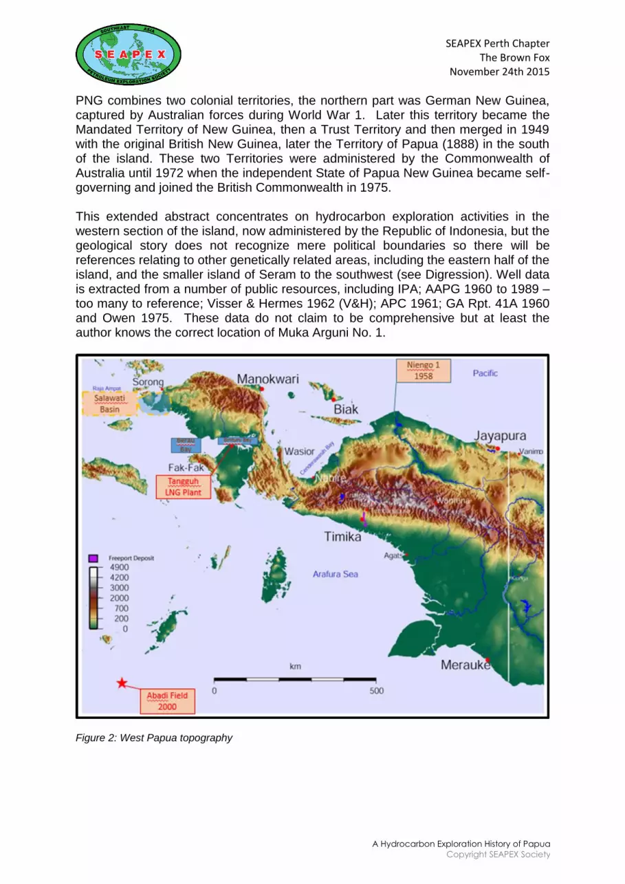
This extended abstract concentrates on hydrocarbon exploration activities in the western section of the island, now administered by the Republic of Indonesia, but the geological story does not recognize mere political boundaries so there will be references relating to other genetically related areas, including the eastern half of the island, and the smaller island of Seram to the southwest (see Digression). Well data is extracted from a number of public resources, including IPA; AAPG 1960 to 1989 – too many to reference; Visser & Hermes 1962 (V&H); APC 1961; GA Rpt. 41A 1960 and Owen 1975. These data do not claim to be comprehensive but at least the author knows the correct location of Muka Arguni No. 1.
Figure 2: West Papua topography
SEAPEX Perth ChapterThe Brown Fox
November 24th 2015
A Hydrocarbon Exploration History of Papua
Copyright SEAPEX Society
Indonesian Papua experienced a very commercial beginning. The VOC, the Dutch East India Company, was formed in 1602 specifically to exploit the Moluccan spice trade, displacing the well-established Portuguese. It started with a 21 year long official monopoly, repeatedly renewed. The board of directors consisted of the Heeren 17 who led the first multi-national company paying a handsome 18% annual dividend to its shareholders. During those 200 years the VOC became the effective strong-armed colonial ruler and trader of not only the Moluccas and Papua, but where-ever they had commercial interests. By 1800 the VOC eventually failed due to internal and external corruption, at which point the Netherlands Government took over and expanded its area of control over the entire archipelago. Those VOC policies were merely copied and expanded by the autocratic colonial government.
After the discovery of oil in North Sumatra by a tobacco farmer, A. J. Zylker, in 1871 the local government in Batavia permitted Royal Dutch Shell to form BPM (Bataafsche Petroleum Maatschappij). BPM then explored the entire western parts of the Netherlands East Indies as far east as the island of Seram (Bula Field). No effort was made to enter New Guinea until 1920, when the western side of the island finally came under the control of the Batavia colonial government. This was followed by the formation of NNGPM (Nederlandsche Nieuw Guinee Petroleum Maatschappij) in 1935 and their E&P operations began in 1936. NNGPM‟s activities followed the „Ethical Policy‟ introduced by the colonial government in 1901 and not too many „palangs‟ were placed on the Babo office doors. After the end of the war in 1945, Dutch efforts to re-establish their colony failed and the Netherlands was forced to recognise Indonesian sovereignty in December 1949. However, the western half of the island of New Guinea remained in the control of NNGPM and the Netherlands.
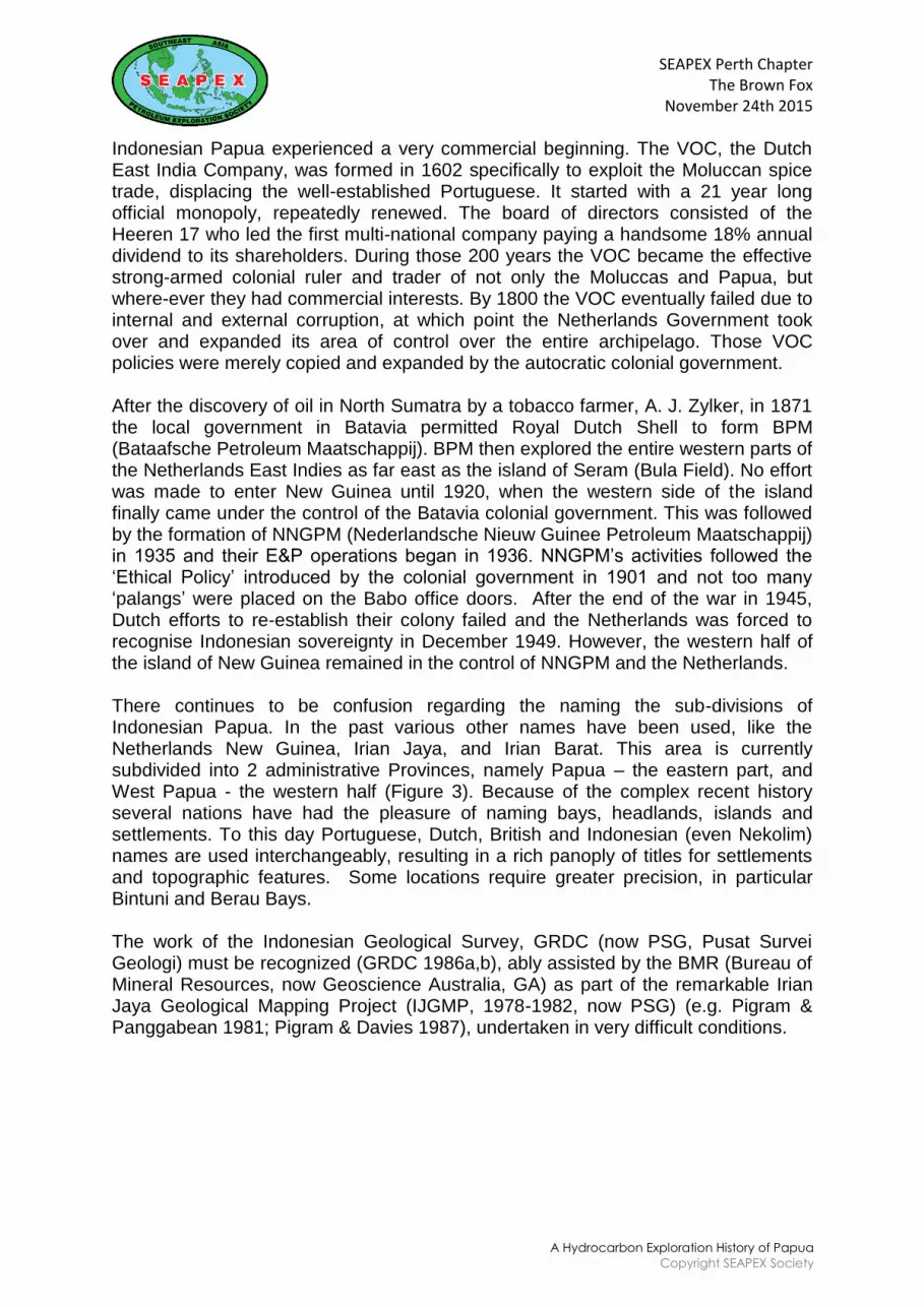
There continues to be confusion regarding the naming the sub-divisions of Indonesian Papua. In the past various other names have been used, like the Netherlands New Guinea, Irian Jaya, and Irian Barat. This area is currently subdivided into 2 administrative Provinces, namely Papua – the eastern part, and West Papua - the western half (Figure 3). Because of the complex recent history several nations have had the pleasure of naming bays, headlands, islands and settlements. To this day Portuguese, Dutch, British and Indonesian (even Nekolim) names are used interchangeably, resulting in a rich panoply of titles for settlements and topographic features. Some locations require greater precision, in particular Bintuni and Berau Bays.
The work of the Indonesian Geological Survey, GRDC (now PSG, Pusat Survei Geologi) must be recognized (GRDC 1986a,b), ably assisted by the BMR (Bureau of Mineral Resources, now Geoscience Australia, GA) as part of the remarkable Irian Jaya Geological Mapping Project (IJGMP, 1978-1982, now PSG) (e.g. Pigram & Panggabean 1981; Pigram & Davies 1987), undertaken in very difficult conditions.
SEAPEX Perth ChapterThe Brown Fox
November 24th 2015
A Hydrocarbon Exploration History of Papua
Copyright SEAPEX Society
Figure 3: West Papua political sub-divisions
EARLY DAYS OF EXPLORATION
Ever since the European „discovery‟ of the area by Portuguese and Dutch sailors in the early 16th century, explorers have become fascinated by the shores of the island of New Guinea. In 1526-27, Don Jorge de Meneses came upon the principal island and named it "Papua". However, little attempt was made to unravel the geology of the country until the end of the 19th Century. This is unsurprising given the logistical difficulties still encountered in such a remote location. Here are some key events:
1705: Rumphius described belemnites from the Sula islands, immediatelywest of Papua. (van Gorsel, 2014)
1876: Luigi d‟Albertis steamed 900 km up the Fly River in 1876 with the MVNeva. Altitude above sea level at that point = +18m. (d‟Albertis 1880;Schumacher 1954; Goode 1977; van Gorsel 2013)
1903: Dr. A Wichmann, who led the first specifically geological investigation ofthe northern coastal regions of Netherlands New Guinea. (van Gorsel 2013)
1906: Dr. H Hirschii was the first recorded hydrocarbon explorer, investigatingthe Bomberai and Etna Bay areas. Oil seeps were already recognised - seeNNGPM map (V&H Fig. 1, p18; van Gorsel 2013)
1913: Dr. Georg Boehm identified ammonites collected by Wichmann‟s 1903expedition from the Birds Neck and northern Lengguru Fold and Thrust Belt.These fossils were recovered from a fine grained deep marine shale andthese were identified as of Bajocian to Callovian in age (van Gorsel 2012).This would place them immediately below the significant unconformityrecognized within
SEAPEX Perth ChapterThe Brown Fox
November 24th 2015
A Hydrocarbon Exploration History of Papua
Copyright SEAPEX Society
the Callovian (Fraser et al 1993), recognized in the Australian North West Shelf as J30 in the monumental Marshall & Lang paper, 2013
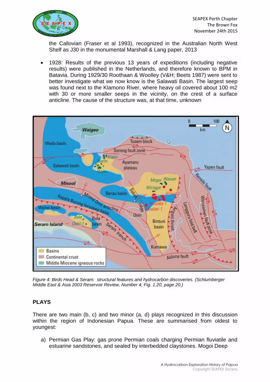
1928: Results of the previous 13 years of expeditions (including negativeresults) were published in the Netherlands, and therefore known to BPM inBatavia. During 1929/30 Roothaan & Woolley (V&H; Beets 1987) were sent tobetter investigate what we now know is the Salawati Basin. The largest seepwas found next to the Klamono River, where heavy oil covered about 100 m2with 30 or more smaller seeps in the vicinity, on the crest of a surfaceanticline. The cause of the structure was, at that time, unknown
Figure 4: Birds Head & Seram: structural features and hydrocarbon discoveries. (Schlumberger Middle East & Asia 2003 Reservoir Review, Number 4, Fig. 1.20, page 20.)
PLAYS
There are two main (b, c) and two minor (a, d) plays recognized in this discussion within the region of Indonesian Papua. These are summarised from oldest to youngest:
a) Permian Gas Play: gas prone Permian coals charging Permian fluviatile andestuarine sandstones, and sealed by interbedded claystones. Mogoi Deep
SEAPEX Perth ChapterThe Brown Fox
November 24th 2015
A Hydrocarbon Exploration History of Papua
Copyright SEAPEX Society
which tested gas from naturally fractured sands is the only notable discovery. This discovery has not been commercialised
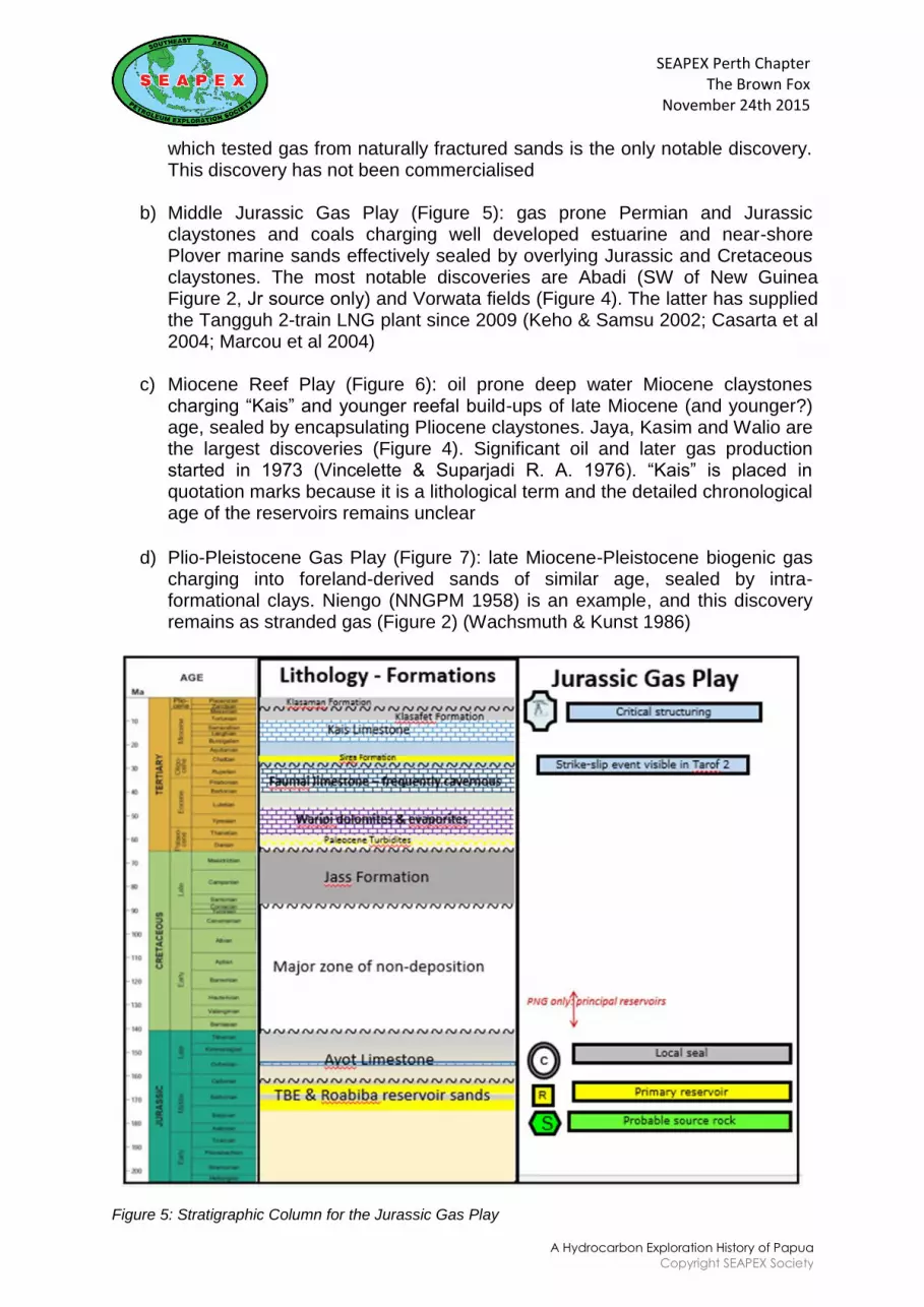
b) Middle Jurassic Gas Play (Figure 5): gas prone Permian and Jurassic claystones and coals charging well developed estuarine and near-shore Plover marine sands effectively sealed by overlying Jurassic and Cretaceous claystones. The most notable discoveries are Abadi (SW of New Guinea Figure 2, Jr source only) and Vorwata fields (Figure 4). The latter has supplied the Tangguh 2-train LNG plant since 2009 (Keho & Samsu 2002; Casarta et al 2004; Marcou et al 2004)
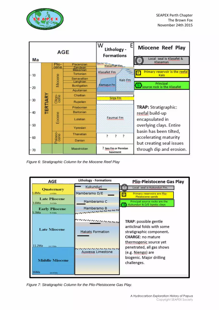
c) Miocene Reef Play (Figure 6): oil prone deep water Miocene claystonescharging “Kais” and younger reefal build-ups of late Miocene (and younger?)age, sealed by encapsulating Pliocene claystones. Jaya, Kasim and Walio arethe largest discoveries (Figure 4). Significant oil and later gas productionstarted in 1973 (Vincelette & Suparjadi R. A. 1976). “Kais” is placed inquotation marks because it is a lithological term and the detailed chronologicalage of the reservoirs remains unclear
d) Plio-Pleistocene Gas Play (Figure 7): late Miocene-Pleistocene biogenic gascharging into foreland-derived sands of similar age, sealed by intra-formational clays. Niengo (NNGPM 1958) is an example, and this discoveryremains as stranded gas (Figure 2) (Wachsmuth & Kunst 1986)
Figure 5: Stratigraphic Column for the Jurassic Gas Play
SEAPEX Perth ChapterThe Brown Fox
November 24th 2015
A Hydrocarbon Exploration History of Papua
Copyright SEAPEX Society
Figure 6: Stratigraphic Column for the Miocene Reef Play
Figure 7: Stratigraphic Column for the Plio-Pleistocene Gas Play.
SEAPEX Perth ChapterThe Brown Fox
November 24th 2015
A Hydrocarbon Exploration History of Papua
Copyright SEAPEX Society
HYDROCARBON HISTORY – the Birth of NNGPM
In 1931, negotiations started between BPM with the companies Stanvac and Caltex we now know as ExxonMobil, and Chevron. This was probably in response to existing exploratory activities in the two Territories which would later become PNG to the east. By 1935, agreement was complete. The Government of the Netherlands in Europe awarded a newly formed company a 10 year exploration contract, with generous terms including an exclusive area of 100,000 km2 with relinquishment provisions of 25,000 km2 after the first 3 years, and another 25,000 km2 after the following 2 years. A small annual fee based on acreage and a sliding scale Net Profit Interest (NPI) of 10-20% were agreed, with a 10 year drilling moratorium. The final block size was to be a mere 10,000 km2 valid until January 1st, 1986.
SECTION 1 (1936-1942 NNGPM 1): This represents the first period of NNGPM‟s operatorship in Netherlands New Guinea, and was not very successful in terms of finding hydrocarbon resources. By 1936 their HQ was established at Babo, unknowingly on the flanks of a Jurassic structure. Field gravity stations – neither accurate nor reliable - were the principal technology employed, until the advent of reflection seismic in 1938. To assist in recognizing surface anticlines prior to gravity surveying, the entire 10,000,000 hectare licence area had been aerially photographed by KLM by the end of 1938. Despite the extremely rugged terrain and challenging logistics, an average of about 3 exploration wells were drilled per year during those 5 years before WW2 erupted. However, requests were already being made for contract modifications to compensate for the extreme conditions. From the very beginning, seismic data interpreters soon realized that most energy was absorbed by the Miocene and Oligocene limestones, leaving them blind below this horizon. Field mapping also covered the eastern part of the Birds Head, including parts of the Lengguru Fold Belt, together with the area between the Arguni Bay and Bintuni Bay. NNGPM exploration staff considered these areas non-prospective. However, the Mesozoic oil seeps in the Kembelangan area were considered of interest for further investigation. All the 17 New Field Wildcats (NFW) wells drilled, totaling around 15,000 metres, targeted the “Kais” and younger carbonates in reefal build-ups. Three discoveries were made: the 14˚API biodegraded oil of Klamono was developed on the existing oil seep; and the Mogoi and Wasian discoveries discovered by field mapping in remote northern Bintuni followed in 1940. See Table 1 and Figure 4 for more details.
SECTION 2 (1948-1960 NNGPM 2): After the end of WW2, NNGPM re-established itself very quickly in their new HQ in Sorong. During the next 12 years, 50 NFW wells were drilled, totaling an extraordinary 70,000 metres of exploration drilling. Reflection seismic became the norm after about 1953. Three discoveries were made, Klamono West, Klamumuk and Niengo. The first two were in the established Miocene Kais play, while Niengo was in an extremely remote location (Figure 2), and represents New Guinea‟s first stranded (biogenic) gas discovery. The greatest public legacy of NNGPM‟s involvement in Papuan exploration has to be the detailed report and maps published by Visser and Hermes in 1962.
SEAPEX Perth ChapterThe Brown Fox
November 24th 2015
A Hydrocarbon Exploration History of Papua
Copyright SEAPEX Society
SECTION 3 (1960-1971 pre-TBE): Following on the political upheaval that resulted in the Republic of Indonesia „assimilating‟ Dutch New Guinea, no exploration work took place within the area for the best part of 10 years. In 1970, after the establishment of the new PSC environment, Petromer Trend started exploration in the Salawati Basin. Improved reflection seismic technology allowed for reasonable data to be acquired along the various rivers that traversed the previous NNGPM exploration area. From the river seismic, Trend then acquired land based detailed seismic data wherever there was encouragement from the river data, using helicopters and digital onsite processing. Drilling began in 1972 with the discovery of 4 new fields in the Miocene Reef Play, followed by early production of 40,000 BOPD starting in September 1973 (Vincelette & Suparjadi 1976). This was a very different result from the previous exploration, thanks to technology drivers. The first to explore offshore Indonesian Papua were seismic vessels working for Phillips, whose first two offshore wells were drilled south of the Birds Head, in the Arafura Sea, followed by 4 more wells close to the northern part of the Birds Head. The last of these 4 wells, TBE 1 (Teluk Berau Prospect E 1) was drilled in 1971 on a pronounced NNW/SSE anticlinal feature (the “Sekak Ridge” of Figure 4) that appeared to bring much older rocks relatively close to the seabed. This well encountered gas shows in a clean sandstone which was identified to be of Jurassic age. An excellent summary including detailed fieldwork of the Mesozoic exploration of the Birds Head area is given by Froidevaux (1978). Later work (Fraser et al., 1993) places this well and others in the correct stratigraphic position (MJ4-EJ1, ibid.) and also provides wireline logs. The lower part of the key reservoir horizon of the area has now been recognised – and therefore this well is considered an exploration watershed.
SECTION 4 (1971-1990 post-TBE): Post–TBE, most wells continued to target the Miocene “Kais” limestone in a reefal build-up or shelf margin facies. 85% of all NFW wells targeted the “Kais”, a total of 169 wells, but with widely varying success rate. By far the most successful was the Petromer Trend venture in the Salawati Basin, south of the regional center of Sorong. Other companies, notably Conoco, Gulf, Marathon, Sun and Phillips tried to emulate that success in areas well away from the Salawati „sweet spot‟ but without success. Meanwhile Trend steadily developed all their 21 new oil discoveries, totaling at least 350 MMBO of commercial reserves, all onshore and relatively easily developed via the KMT export point. During these 20 years (1971-1990) nearly 200 NFW wells were drilled within the area of Indonesian Papua, totaling a formidable 360,000 metres of drilling. Only 6% of all the NFW in this post-TBE world explored the Jurassic, mostly offshore and covering the entire marine area even as far east as Merauke. Another 9 wells were drilled in the Biak and Mamberamo area in northern Papua, close to the NNGPM Niengo discovery. However, drilling problems, well-bore instability and over-pressure conspired to make this a very difficult area to drill and test. Other wells, targeting the Mesozoic were deepened into the Permian or older rocks, all were P&A dry, with no successes. The final well in this section of the story is OXY‟s 1990 Roabiba-1 well (Figure 4), drilled just a little to the east of TBE. Roabiba-1 encountered a gas charged Jurassic sand, slightly younger than the TBE reservoir, and tested at 23.6 MMCFGPD. With this well the Jurassic play had been proven as a viable producer. But it remained stranded gas. Roabiba represents the next exploration watershed after TBE.
SEAPEX Perth ChapterThe Brown Fox
November 24th 2015
A Hydrocarbon Exploration History of Papua
Copyright SEAPEX Society
SECTION 5 (1990-1997 post-Roabiba): The years 1990 through 1997 represent the next stage in the search for major hydrocarbon resources in Indonesian Papua. These 6.5 years saw exploration rates drop from 10 to less than 4 wells per year, but this drop was not solely caused by geological factors. Variations in the Indonesian PSC regulations, uncertainty about the sanctity of contracts and political variations also influenced the exploration rates, together with oil price falls. Wells were drilled in ever more remote locations, even within the Lengguru Fold Belt, but the late Jurassic and early Cretaceous reservoirs, already proven productive in PNG just across the political boundary from Indonesia, contrasted sharply with the Middle Jurassic reservoirs of Bintuni Bay. Efforts were made to make the geological connection between PNG and the main fold and thrust belt of Papua without major success. Exploration for the “Kais” reef play continued to greater depths on Salawati Island itself, and were proven successful, adding a further 4 discoveries to the area. The Permian play was also tested successfully at last, but Mogoi Deep remains stranded gas. When ARCO drilled a location originally pegged by Conoco and tested gas from a variety of reservoirs, including a new Paleocene turbidite sequence, significant excitement was caused (Casarta et al 2004). Less than 3 years later, the ARCO Vorwata 1 (Figure 4) major discovery finally established a commercial base for the Middle Jurassic Gas Play. This event, in 1997, is the next major exploration watershed. The next challenge was to bring the discovery to market.
SECTION 6 (1997-2009 post-Vorwata): To prove up sufficient gas for Indonesia‟s third LNG plant which started in 2009, ARCO and BG drilled a number of appraisal wells in the Vorwata area. The wells were deep and challenging, and the cavernous limestones below the “Kais“ caused significant drilling problems. The limestone had been very strongly karstified prior to burial in the Berau Bay area; a condition not observed in the Salawati area. Seismic energy is lost in and dispersed by the cavernous limestones, which incidentally continue to have a strong freshwater flow thanks to rainwater supply in the Ayamaru Plateau (Figure 4) in the Birds Head. Surface freshwater flow had already been recorded by early operators whose seismic data in Berau and Bintuni bays was further degraded by their streamers sinking in the water due to density variations. This active freshwater flow is recorded in many Kais wells within the Bintuni Basin, removing any opportunity for hydrocarbon trapping within the Kais. Exploration was halted in the attractive Sareba PSC at the northern (oldest) tip of the Lengguru Fold and Thrust Belt (Hill et al 2001) due to Forestry and Conservation issues. Only new field wildcats (NFW) qualify in the data tabulated in Table 1. As appraisal and development wells do not qualify here - only 3 additional Jurassic discoveries were made by 2009, only one of which tested gas within Bintuni Bay. The super-giant Abadi Field, discovered by INPEX in 2000 is now being developed using FLNG technology. The Abadi Field provides a Middle Jurassic reservoir link between Papua and the Australian fields in the Bonaparte and Browse areas to the south. The third was a small oil discovery in the Central Ranges which remains undeveloped, also blighted by both red and green tape challenges including Forestry and Conservation issues. The BP operated Tangguh „group‟ received approval to go ahead with the eponymous LNG plant in early 2005 (Marcou et al 2004), and gas was available from the first of the 2 unmanned Vorwata platforms in 2008 but the first cargo of LNG did not load and sail until July 2009. At last the Middle Jurassic reservoir‟s potential had become of commercial value. Another and possibly most relevant exploration watershed had been reached.
SEAPEX Perth ChapterThe Brown Fox
November 24th 2015
A Hydrocarbon Exploration History of Papua
Copyright SEAPEX Society
SECTION 7 (2009-2015 post-LNG): Once the LNG plant was operational, exploration continued for further gas reserves, both onshore and offshore. Some additional resource has been discovered onshore, while offshore exploration has resulted in expensive disappointments. There is a plan to construct a third LNG train at Tangguh, but it remains unclear where the required reserves will come from. However, the original play in Indonesian Papua – the Miocene “Kais” reef play continued to be active with several additional discoveries. The Arafura Sea area to the south of Indonesian Papua also saw several wells drilled to stratigraphically deep horizons, but with little encouragement. Two of the four recognized Play types have yet to prove their worth commercially.
DIGRESSION
Although outside the remit of this abstract, the activities on the island of Seram (Figure 8), south-west of Papua deserve mention because commercial quantities of oil were discovered there in 1897, by BPM, the Royal Dutch Shell affiliate which explored the rest of the Netherlands East Indies, and who negotiated the NNGPM contract.
Figure 8: Map of eastern Seram, showing the Bula and Oseil fields. (Lion Energy Ltd., ASX Announcement 14th July 2008)
The main oilfield, Bula, was located by coastal seeps and was developed successfully with many drilling pads just offshore, see Figure 9. The oil is generated from Triassic source rocks but trapped in Pleistocene age Fufa sands near surface. The same source rock is also responsible for the Oseil and Lofin discoveries to the south-east, in complex thrust sheets of recrystallized Triassic limestones (Charlton & Van Gorsel, 2014). The dynamics of this Petroleum System are so strong that any pit dug in the coastal region is likely to fill with crude oil. The statistics in Table 1 do not include Seram wells.
SEAPEX Perth ChapterThe Brown Fox
November 24th 2015
A Hydrocarbon Exploration History of Papua
Copyright SEAPEX Society
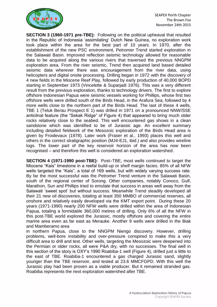
Figure 9: Bula Oilfield under attack c. 1944 showing the shallow water production facilities similar to Maracaibo, Venezuela. http://www.combinedfleet.com/Ceramoil.htm
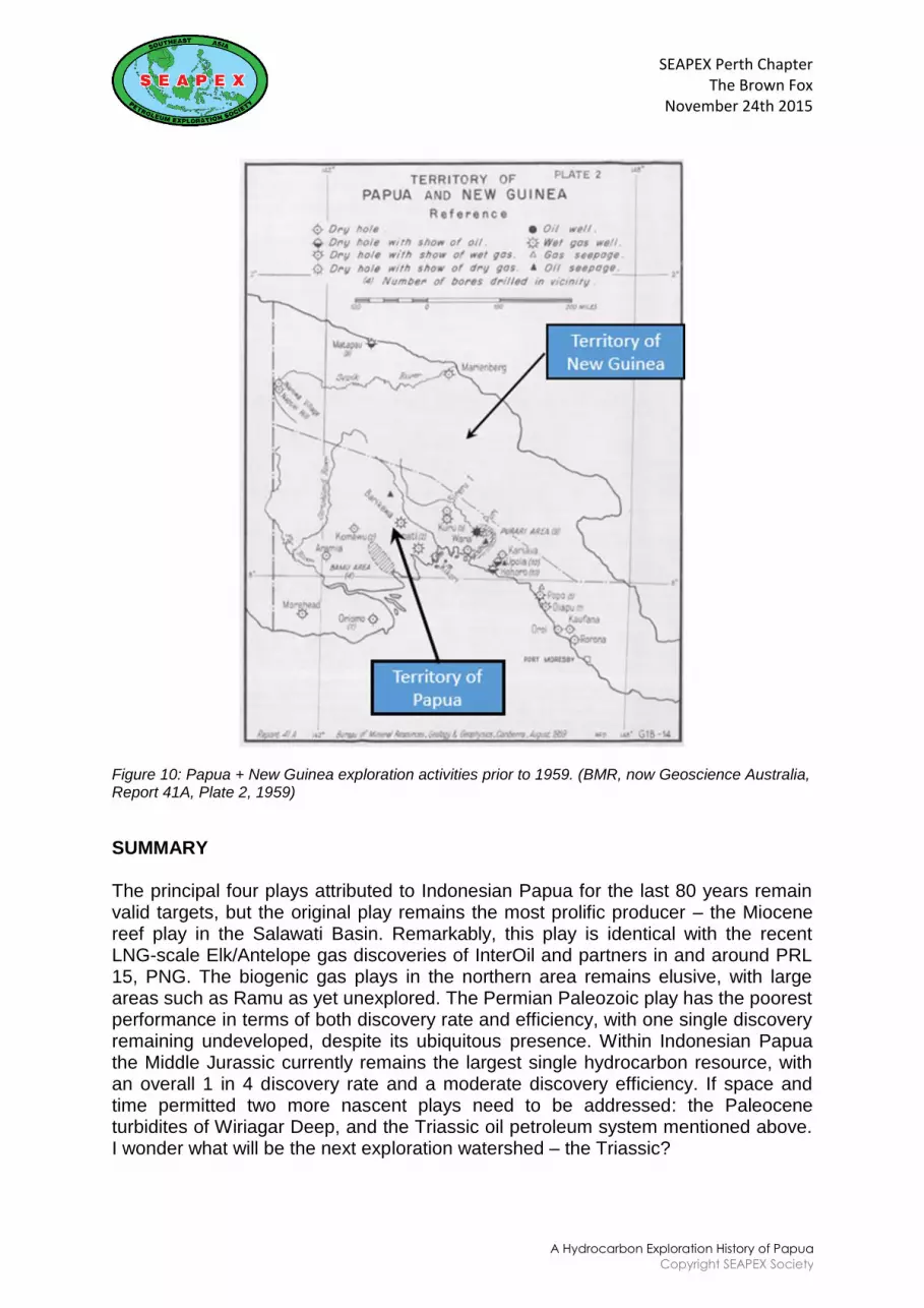
It is also revealing to note the activities and results of exploration in PNG to the east (Figure 10 and see also APC and GA Rpt. 41A). The first major oil seeps were recorded in 1911 about 250 km north west of the capital Port Moresby near the mouth of the Vailala River.
Between 1912 and 1927 a number of shallow bores (Upoia, Hohoro) were drilled in this area with nothing more than oil and gas shows, in contrast with the Klamono story, but eerily reminiscent of NNGPM‟s Kembelangan well. Most seeps appeared to be from late Miocene claystones, and as in Netherlands New Guinea, the principal reservoir was thought to be the Miocene Darai limestone, the lithological equivalent of the Kais further west.
By 1937 geological surveys had been made of surface exposures close to many of the accessible rivers of PNG, and the extreme difficulties of logistics became well known in the thrust belt mountains. A number of shallow bores were drilled in the period up to 1942, but no significant discoveries were reported. Rocks of Tertiary to Mesozoic age had been identified by surface geological surveys, but no integrated picture was developed of the complex geology until well into the 1960‟s. A good summary of the Hides discovery can be found in Grainge et al, 1990. Development and monetization of PNG gas has taken a long time, with the first LNG shipment from the Hides-Angore-Juha fields by ExxonMobil departing in May 2014, 27 years after the first discovery. The statistics in Table 1 do not include PNG wells.
Figure 10: Papua + New Guinea exploration activities prior to 1959. (BMR, now Geoscience Australia, Report 41A, Plate 2, 1959)
SUMMARY
The principal four plays attributed to Indonesian Papua for the last 80 years remain valid targets, but the original play remains the most prolific producer – the Miocene reef play in the Salawati Basin. Remarkably, this play is identical with the recent LNG-scale Elk/Antelope gas discoveries of InterOil and partners in and around PRL 15, PNG. The biogenic gas plays in the northern area remains elusive, with large areas such as Ramu as yet unexplored. The Permian Paleozoic play has the poorest performance in terms of both discovery rate and efficiency, with one single discovery remaining undeveloped, despite its ubiquitous presence. Within Indonesian Papua the Middle Jurassic currently remains the largest single hydrocarbon resource, with an overall 1 in 4 discovery rate and a moderate discovery efficiency. If space and time permitted two more nascent plays need to be addressed: the Paleocene turbidites of Wiriagar Deep, and the Triassic oil petroleum system mentioned above. I wonder what will be the next exploration watershed – the Triassic?
SEAPEX Perth ChapterThe Brown Fox
November 24th 2015
A Hydrocarbon Exploration History of Papua
Copyright SEAPEX Society
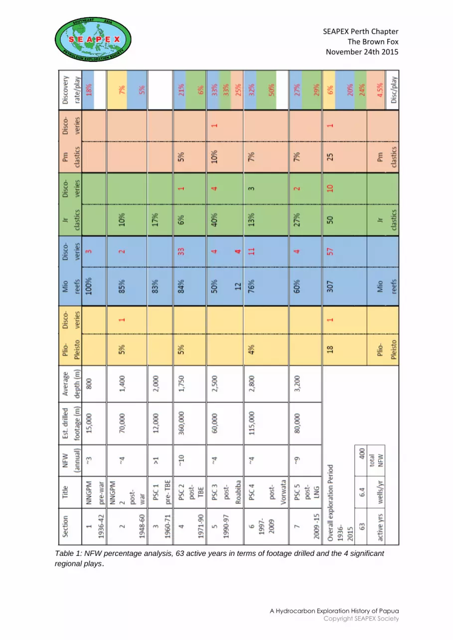
Table 1: NFW percentage analysis, 63 active years in terms of footage drilled and the 4 significant
regional plays.
SEAPEX Perth ChapterThe Brown Fox
November 24th 2015
A Hydrocarbon Exploration History of Papua
Copyright SEAPEX Society
ACKNOWLEDGMENTS
I acknowledge the encouragement and collaboration of many fellow explorers in many different countries during the past several years, in particular Han van Gorsel, Simon Lang and Mike Clutson who permitted many digressions. Rebecca Fraser helped bring order and improved the sense and readability of the text. Any and all errors are mine, and mine only.
REFERENCES
APC: Australasian Petroleum Company. 1961. Geological results of petroleum exploration in western Papua 1937-1961 (compilers C.A.E. O'Brian, K.W. Gray & I. Gillipie). J. Geol. Soc. Australia 8, 1, p. 1-133. Beets, C. 1987. Neogene Mollusca from the Vogelkop (Bird's Head Peninsula), West Irian, New Guinea. Scripta Geol., 82: 101-134, 2 figs., pis 8-11, Leiden. http://www.repository.naturalis.nl/document/148746. Casarta L. J., Salo J. P., Suherman T., Sampurno S. 2004. Wiriagar Deep: the frontier discovery that triggered Tangguh LNG. IPA Proc. Deepwater & Frontier Exploration in SE Asia & Australasia Symposium, Jakarta. Charlton, T. R., & Van Gorsel, J. T. 2014. The Manusela Limestone in Seram: Late Triassic age for a „Jurassic‟ petroleum play. Berita Sedimentologi 31, p. 57-69. http://www.iagi.or.id/fosi/files/2014/12/BS31-Biostratigraphy_SEAsia_Part3.pdf Commonwealth Bur. Min. Resour. Geol & Geophys. 1960. Summary of Oil Search activities in Australia and New Guinea to end June 1959. Rep. Bur. Min. Resour. Aust., Report 41A. D‟Albertis L. M. 1880. New Guinea: What I did and what I saw. Vol 2. Sampson, Low, Marston, Searle & Rivington, London. Fraser, T.H., J. Bon & L. Samuel. 1993. A new dynamic Mesozoic stratigraphy for the West Irian microcontinent, Indonesia, and its implications. Proc. 22nd Ann. Conv. Indon. Petrol. Assoc., p. 707-761. Froidevaux, C.M. 1978. Tertiary tectonic history of Salawati area, Irian Jaya, Indonesia. AAPG Bull. 62, p. 1127-1150. G.R.D.C., Bandung. 1986a. Geologic Map of the Eastern part of Papua. Scale 1:1,000,000. G.R.D.C., Bandung. 1986b. (Dow, D.B., G.P. Robinson, U. Hartono & N. Ratman) Geologic Map of the Western part of Papua. Scale 1:1,000,000. Goode, J. 1977. Rape of the Fly. Nelson, Melbourne, VIC. Grainge, A.M., A.J.D. Hine & P.J. Brawley, 1990. Discovery and development of the Hides gas field in Licence PPL 27, Papua New Guinea. In: G.J. & Z. Carman (eds.) Petroleum exploration in Papua New Guinea, Proc. First PNG Petroleum Conv., Port Moresby, p. 539-550. Hill K. C., Hoffman N., Lunt P., Paul R. Structure and hydrocarbons in the Sareba PSC, “Birds Neck”, West Papua. 2001. Proc. 28th Ann. Conv. Indon. Petrol. Assoc., p. 227-248.Keho, T., and Samsu, D. 2002. Depth Conversion of Tangguh Gas Fields, in Society of Exploration Geophysicists Journal, The Leading Edge, October 2002, p. 966-971.
SEAPEX Perth ChapterThe Brown Fox
November 24th 2015
A Hydrocarbon Exploration History of Papua
Copyright SEAPEX Society
Marcou J. A., Samsu D., Kasim A., Meizarwin, Davis N. 2004. Tangguh LNG‟s gas Resource: Discovery, Appraisal and Certification. IPA Proc. Deepwater & Frontier Exploration in SE Asia & Australasia Symposium, Jakarta. Marshall N. G. & Lang S. C. 2013. A new stratigraphic framework for the North West Shelf, Australia. In: M. Keep & S.J. Moss (eds.) The sedimentary basins of Western Australia IV, Proc. PESA Symposium, Perth, p. 1-32. Owen, E. W. 1975. Trek of the Oil Finders: A History of Exploration for Petroleum. Sections 1, 2, 4, 5, 9. A.A.P.G. Tulsa OK. Pigram, C.J. & H.L. Davies. 1987. Terranes and the accretion history of the New Guinea orogen. Bur. Min. Res. J. Australian Geol. Geoph. 10, 3, p. 193-212. Pigram, C.J. & H. Panggabean. 1981. Pre-Tertiary geology of western Irian Jaya and Misool Island: implications for the tectonic development of Eastern Indonesia. Proc. 10th Ann. Conv. Ind. Petr. Ass., p. 385- 399. Schumacher, C., 1954. Nieuw Guinea de ontwikkeling op economisch, social en cultureel gebeid, in Nederlands en Australisch Nieuw Guinea. Hoofdstuk I, pp. 1-120. Staatsdrukkerij- en uitgeverijbedrijf „s-Gravenhage. Van Gorsel, J.T. 2012. Middle Jurassic ammonites from the Cendrawasih Bay coast and North Lengguru foldbelt, West Papua: implications of a „forgotten‟ 1913 paper. Berita Sedimentologi 23, p. 35-41. (online: http://www.iagi.or.id/fosi/files/2012/03/FOSI_BeritaSedimentologi_BS-23_March2012.pdf) Van Gorsel, J.T. 2013. Bibliography of Indonesian Geology, Edition 5. Online at: www.vangorselslist.com Van Gorsel, J. T. 2014. An introduction to Mesozoic faunas and floras of Indonesia. Berita Sedimentologi 31, p. 27-56. http://www.iagi.or.id/fosi/files/2014/12/BS31-Biostratigraphy_SEAsia_Part3.pdf. Vincelette, R.R. & R.A. Soeparjadi. 1976. Oil-bearing reefs in Salawati Basin of Irian Jaya, Indonesia. AAPG Bull. 60, p.1448-1462. Visser, W.A. & J.J. Hermes. 1962. Geological results of the exploration for oil in Netherlands New Guinea. Verh. Kon. Nederl. Geol. Mijnbouwk. Genootschap, Geol. Series 20, p. 1-265. Wachsmuth, W. & Kunst F. 1986. Wrench fault tectonics in Northern Irian Jaya. Proc. 15th Ann Conv. Indon. Petrol. Assoc. 1, p. 371-376.