14
FABRIZIO SERRA EDITORE PISA · ROMA ACTA VULCANOLOGICA 23 · 1 - 2 · 2011 / 24 · 1 - 2 · 2012 OFFPRINT
| Date post: | 27-Nov-2023 |
| Category: |
Documents |
| Upload: | independent |
| View: | 0 times |
| Download: | 0 times |
FABRIZIO SERRA EDITOREPISA · ROMA
CONTENTS
Orlando Vaselli, Bruno Capaccioni, Foreword 9Antonio Capponi, Danilo M. Palladino, Jacopo Taddeucci, Piergiorgio Scarlato, Parameterizing
the dynamics of Strombolian eruptions through high-speed video analysis 11Maurizio Mulas, Filippo Mundula, Raffaello Cioni, Stratigraphy of the rheomorphic, densely welded,
Monte Ulmus Ignimbrite (sw Sardinia, Italy) 17Chiara B. Cannata, Rosanna De Rosa, Bruce Houghton, Paola Donato, Andrea Nudo, Pele’s hair:
case studies from Kilauea Volcano and Vulcanello (Aeolian Islands) 27Rosario Raffaele, Luciano Scarfì, Martine Sapin, Mireille Laigle, Philippe Charvis, Jordi Diaz,
Sebastiano Imposa, Seismic activity in Central Lesser Antilles subduction zone from a combined on-/offshore net-work 35
Mariantonietta Longobardi, Luca D’Auria, Antonietta Maria Esposito, Relative location of hybridevents At Stromboli Volcano, Italy 39
Rossella Di Napoli, Alessandro Aiuppa, Elise Fourré, Philippe Jean-Baptiste, Francesco Parel-lo, Patrick Allard, Sergio Calabrese, Elyes Gaubi, Abdallah Ben Mamou, Mariano Valenza,Deep reservoir temperatures of low-enthalpy geothermal systems in Tunisia: new constraints from chemistry of ther-mal waters 43
Marco Doveri, Barbara Nisi, Andrea Cerrina Feroni, Alessandro Ellero, Matia Menichini,Matteo Lelli, Giulio Masetti, Simone Da Prato, Claudia Principe, Brunella Raco, Geological,hydrodynamic and geochemical features of the volcanic aquifer of Mt. Amiata (Tuscany, Central Italy): an overview 51
Orlando Vaselli, Barbara Nisi, Franco Tassi, Daniele Rappuoli, Valeria Pancioli, Simone Uc-ciero, Luciano Giannini, CO2 hazard vs touristic attraction at the Mt. Amiata Volcano (Italy) 73
Sebastian Vogel, gis-based geomorphometric analysis of Somma-Vesuvius volcanic complex: estimating the altitudeof Mt. Somma stratovolcano before its caldera-forming explosive activity 81
Conferences and Symposia 89
ISSN 1121-9114ISSN ELETTRONICO 1724-0425
ACTAVULCANOLOGICA
23 · 1-2 · 2011 / 24 · 1-2 · 2012
23· 1
- 2 ·
2011
/24
· 1- 2
· 20
12A
CT
A V
UL
CA
NO
LO
GIC
A
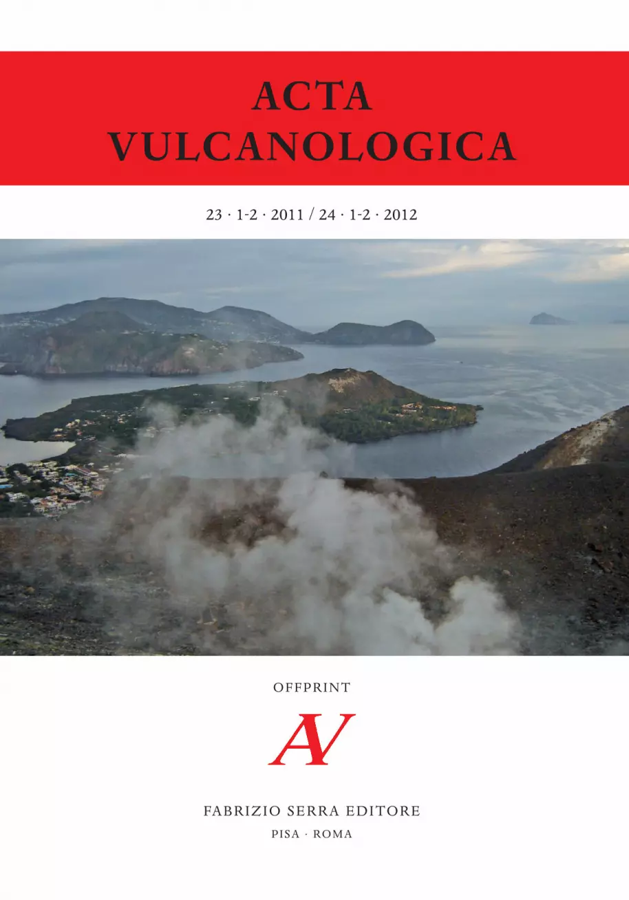
Front of cover: The Eolian Islands from the La Fossa Crater of Volcano Island.
OFFPRINT
Acta Vulcanologica 23-24_Sovracoperta 22/03/13 17:46 Pagina 1
ACTAVULCANOLOGICA
Rivista a cura dell’Associazione Italiana di Vulcanologia (aiv)Journal edited by the Italian Association of Volcanology (aiv)
Chief-Editors
Bruno Capaccioni, Department of Earth and Environmental Geological Sciences, Piazza Porta San Donato 1,I 40126 Bologna (Italy)
Raffaello Cioni, Department of Earth Sciences, Via Trentino 51, I 09127 Cagliari (Italy)Orlando Vaselli, Department of Earth Sciences, University of Florence, Via La Pira 4, I 50121 Florence (Italy)
Manuscripts may be submitted to one of the Editors.
*
Publishing House Information«Acta Vulcanologica» is published six-monthly ( June and December)
by Fabrizio Serra editore®, Pisa · Roma.
Subscriptions should be sent to Fabrizio Serra editore®, Casella postale no. 1, Succ. no. 8, I 56123 Pisa (Italy),tel. +39 050 542332, fax +39 050 574888
[email protected], www.libraweb.netPisa Office: Via Santa Bibbiana 28, I 56127 Pisa (Italy)
Rome Office: Carlo Emanuele I 48, I 00185 Rome (Italy)
I prezzi ufficiali di abbonamento cartaceo e/o Online sono consultabilipresso il sito Internet della casa editrice www.libraweb.net.
Print and/or Online official subscription rates are availableat Publisher’s web-site www.libraweb.net.
Payments can be made on our postal current account no. 17154550or by credit card (American Express, Visa, Mastercard, Eurocard)
*
Direttore responsabile: Alberto Pizzigati
Autorizzazione del Tribunale di Pisa n. 14 del 24 maggio 1991
*
«Acta Vulcanologica» is a Peer-Reviewed Journal.The eContent is Archived with Clockss and Portico.

Original Paper «Acta Vulcanologica» · Vol. 23 (1-2), 2011 / 24 (1-2), 2012: 73-80
73
1. Introduction
he knowledge of the geological heritage has an im-portant role in the land management and use, par-
ticularly when i. conservation, ii. environmental educa-tion and iii. basic research are considered. These aspectsbecome more important when peculiar geological fea-tures are associated with potentially hazardous situa-tions, related to volcanoes, landslides, gas emissions andso forth.
The peri-Tyrrhenian side of Italy is characterized bythe presence of several CO2-rich gas discharges, someof them releasing into the atmosphere up to > 1,000ton/day of CO2 (e.g., Chiodini et alii 2000, 2004; Rogieet alii 2000; Gambardella et alii 2004; Minissale 2004).Most of these natural manifestations are located in de-pressed areas, likely originated by either substratumcollapse or gas blasts. This peculiar morphology mayoccasionally provoke CO2 accumulation at ground lev-el, being this gas heavier than air, particularly when cli-matic conditions, i.e., lack of wind and cold air temper-ature, are favorable (e.g., Tassi et alii 2009). In some
cases, a sort of ‘CO2 cloud’ may overflow from the ‘ge-ological container’ and, following topographic lows,generate CO2 floods, lakes and rivers. As a consequenceof this phenomenon, both animals and humans wereinvolved in lethal accidents. In the present work we de-scribe the actions undertaken to face the CO2 hazard inthe n-e sector of Mt. Amiata Volcano (Fig. 1) with theestablishment of a geological path, named «Tourists forCO2». The basic concept is that the CO2 hazard relatedto these gas discharges can be mitigated by rendering fa-miliar local and tourist communities with such spectac-ular geological events.
2. Geological outlines of the Mt. AmiataVolcano and CO2-rich Gas Emissions
Mt. Amiata is an extinct Quaternary (0.3-0.2 Ma - e.g.,Ferrari et alii 1996) volcanic apparatus located in south-ern Tuscany (Central Italy). Its volcanic products aremainly effusive and of silicic composition, they cover anarea of ca. 90 km2 and lie on i. Paleozoic to OligoceneTuscany units, ii. Mesozoic Ligurian units (mainly ophi-
CO2 HAZARD VS TOURISTIC ATTRACTIONAT THE MT. AMIATA VOLCANO (ITALY)
Orlando Vaselli* , 1 , 2 · Barbara Nisi3 · Franco Tassi1 , 2Daniele Rappuoli4 · Valeria Pancioli5 · Simone Ucciero1
Luciano Giannini1 , 2
1. Dipartimento di Scienze della Terra, Università di Firenze, Firenze, Italy2. cnr-igg (Istituto di Geoscienze e Georisorse), Firenze, Italy
3. cnr-igg (Istituto di Geoscienze e Georisorse), Pisa, Italy4. Unione dei Comuni Amiata -Val d’Orcia, Siena, Italy
5. Dipartimento della Protezione Civile -Emilia-Romagna, Bologna, Italy
Abstract
The ne flank of Mt. Amiata, an extinct Quaternary Volcano located in Southern Tuscany (Central Italy), is characterized by a largenumber of CO2-rich dry-vents mainly discharging from depressed areas (up to 10 m deep), predominantly concentrated between Bag-ni S. Filippo thermal spa to the east and Campiglia d’Orcia to the west. The last fatal accident caused by high concentrations of CO2in one of these emissions and related to the Mt. Amiata degassing activity dates back to November 2003, when a hunter and his dogwere suffocated by a CO2 cloud. In 2006 a study aimed to assess the risk related to such CO2 emissions was supported by the TuscanyCivil Protection; since then, new fences were positioned all along the most dangerous areas. This deterrent policy prevented both lo-cals and tourists from visiting this zone for safety reasons. In agreement with the local authorities (Municipality of Castiglione d’Or-cia and the Union of Amiata and Orcia Valley Municipalities, Siena District) and the Department of Earth Sciences of the Universityof Florence, the creation of a CO2 geological path (named «Tourists for CO2») was then proposed. Along the geological path, snakingthrough the most spectacular CO2-rich manifestations, tourists and local people, guided by authorized personnel, may appreciate bub-bling pools, dry gas vents and effects of CO2 on the surrounding vegetation. Illustrative panels, reporting in form of didactic cartoonsthe main topics of the local geology, fauna and flora were positioned along the geo-path along with explicative information on therisks associated with the CO2-rich discharges. This initiative is aimed to promote a direct interaction between the people and a geo-logical phenomenon, according to a ‘see-and-understand’ approach, and to inform how to behave in front of a devious risk such asthat related to CO2 emission. The opening ceremony of this geological path is for May 2012.
Keywords: CO2 hazard, Geological paths, Geotourism, Mt. Amiata (Italy)
T
* Corresponding Author: O. Vaselli: [email protected]
O. Vaselli et alii
74
olites), iii. Paleogene Subligurian units, and iv) Neogenesediments. The emplacement of a still cooling magmabody at the depth of 6-7 km is probably at the origin ofthe uplift of this area in the Quaternary (e.g., Gianelli etalii 1988, Brogi 2007 and references therein) and theanomalous geothermal gradient that presently allowsthe exploitation of geothermal fluids. Geochemical fea-tures of fluid (water and gas) manifestations indicatethe occurrence of three main reservoirs of thermal andcold waters in the Mt. Amiata region. The deepest one(Ca-SO4) with temperatures of 300-350 °C (at > 3,000m) (e.g., Calamai et alii 1970, Gianelli et alii 1988) is lo-cated in an extensive carbonate reservoir sealed by thicksequences of low-permeability allochthonous and neo-autochthonous formations. The two shallower aquiferswith temperatures up to 200-230 °C (at 500-1,000 m)show Ca-HCO3, when hosted in sedimentary forma-tions above the Mesozoic carbonates, and Na-Cl com-positions, the latter being related to marine sedimentsfilling the many post-orogenic nw-se–trending basins(Minissale et alii 1997). Besides of numerous thermalmanifestations, the ne and sw sectors of the Mt. Amia-ta Volcano are characterized by the presence of numer-ous dry gas vents discharging up to 100 ton/day of CO2gases (Vaselli et alii 2006, Tassi et alii 2008, Frondini etalii 2009).
Dry gas vents are commonly associated with youngand recent volcanic systems and seep out from fractures
and depressions, although they are relatively frequent innon-volcanic areas (e.g., Kerrick 2001). Their composi-tion is consisting of almost exclusively CO2 at whichH2S, CH4 and light hydrocarbons and atmosphericcomponents (N2 and Ar) are commonly associated. Lo-cally, dry gas vents may achieve large dimensions (hun-dreds of meters in diameter and tens of meters deep).To testify the hazard related to these dry CO2 emissionsin Central-Southern Africa, local populations use to callthese peculiar manifestations with the Swahili word:mazuku. Literally, mazuku means ‘evil winds’, andstands for «gases that travel and kill people and/or ani-mals» by night (Tuttle et alii 1990, Vaselli et alii 2002-2003, Smets et alii 2010). A legend tells that mazukus arethe sites of «elephant graveyards» of Africa (Anony-mous 1991).
3. The Mt. Amiata dry Gas Ventsand the CO2 Hazard
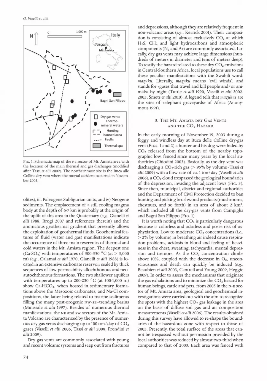
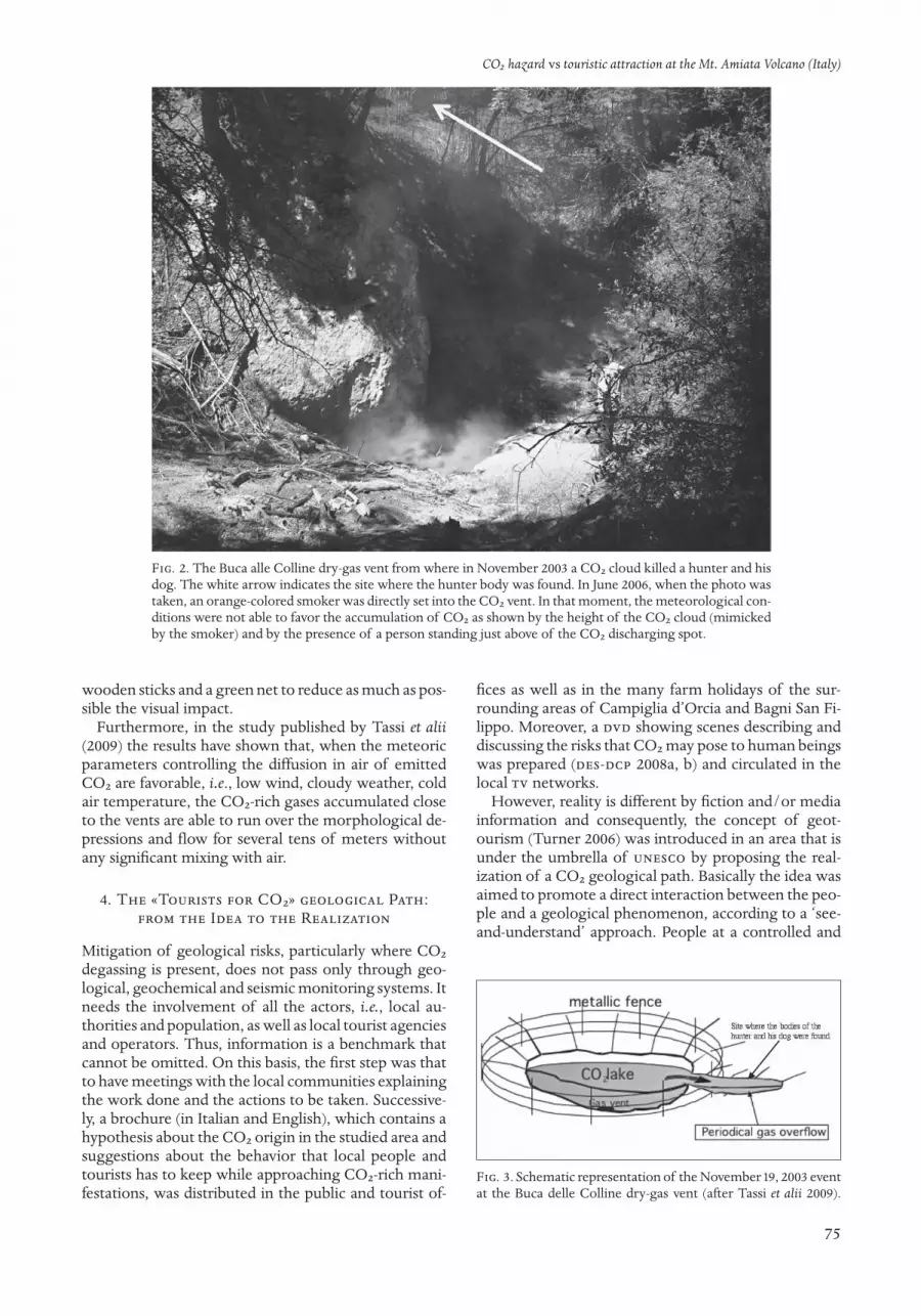
In the early morning of November 19, 2003 during afoggy and windless day at Buca delle Colline dry-gasvent (Figs. 1 and 2) a hunter and his dog were hided byCO2 released from the bottom of the nearby topo-graphic low, fenced since many years by the local au-thorities (Chiodini 2003). Basically, as the dry vent wasdischarging a CO2-rich gas (> 95% by volume - Tassi etalii 2009) with a flow rate of ca. 1 ton/day (Vaselli et alii2006), a CO2 cloud trespassed the geological boundariesof the depression, invading the adjacent lows (Fig. 3).Since then, municipal, district and regional authoritiesand the Department of Civil Protection decided to banhunting and picking brushwood products (mushrooms,chestnuts, and so forth) in an area of about 2 km2,which included all the dry-gas vents from Campigliaand Bagni San Filippo (Fig. 1).
It is worth noting that CO2 is particularly dangerousbecause is colorless and odorless and poses risk of as-phyxiation. Low to moderate CO2 concentrations (i.e.,> 2% by volume) in breathing air indeed cause respira-tion problems, acidosis in blood and feeling of heavi-ness in the chest, sweating, tachycardia, mental depres-sion and tremors. As the CO2 concentration climbsabove 10%, coupled with the decrease in O2, uncon-sciousness and death can quickly be induced (e.g.,Beaubien et alii 2003, Cantrell and Young 2009, Heggie2009). In order to assess the mechanisms that originatethe gas exhalations and to minimize the CO2 hazard forhuman beings, cattle and pets, from 2005 in the n-e sec-tor of Mt. Amiata area, geological and geochemical in-vestigations were carried out with the aim to recognizethe spots with the highest CO2 gas leakage in the areaon the basis of diffuse soil gas and air compositionmeasurements (Vaselli et alii 2006). The results obtainedduring this survey have allowed to re-shape the bound-aries of the hazardous zone with respect to those of2003. Presently, the total surface of the areas that can-not be trespassed without permission provided by thelocal authorities was reduced by almost two-third whencompared to that of 2003. Each area was fenced with
Fig. 1. Schematic map of the ne sector of Mt. Amiata area withthe location of the main thermal and gas discharges (modifiedafter Tassi et alii 2009). The northernmost site is the Buca alleColline dry vent where the mortal accident occurred in Novem-ber 2003.
CO2 hazard vs touristic attraction at the Mt. Amiata Volcano (Italy)
75
wooden sticks and a green net to reduce as much as pos-sible the visual impact.
Furthermore, in the study published by Tassi et alii(2009) the results have shown that, when the meteoricparameters controlling the diffusion in air of emittedCO2 are favorable, i.e., low wind, cloudy weather, coldair temperature, the CO2-rich gases accumulated closeto the vents are able to run over the morphological de-pressions and flow for several tens of meters withoutany significant mixing with air.
4. The «Tourists for CO2» geological Path:from the Idea to the Realization
Mitigation of geological risks, particularly where CO2degassing is present, does not pass only through geo-logical, geochemical and seismic monitoring systems. Itneeds the involvement of all the actors, i.e., local au-thorities and population, as well as local tourist agenciesand operators. Thus, information is a benchmark thatcannot be omitted. On this basis, the first step was thatto have meetings with the local communities explainingthe work done and the actions to be taken. Successive-ly, a brochure (in Italian and English), which contains ahypothesis about the CO2 origin in the studied area andsuggestions about the behavior that local people andtourists has to keep while approaching CO2-rich mani-festations, was distributed in the public and tourist of-
fices as well as in the many farm holidays of the sur-rounding areas of Campiglia d’Orcia and Bagni San Fi-lippo. Moreover, a dvd showing scenes describing anddiscussing the risks that CO2 may pose to human beingswas prepared (des-dcp 2008a, b) and circulated in thelocal tv networks.
However, reality is different by fiction and/or mediainformation and consequently, the concept of geot-ourism (Turner 2006) was introduced in an area that isunder the umbrella of unesco by proposing the real-ization of a CO2 geological path. Basically the idea wasaimed to promote a direct interaction between the peo-ple and a geological phenomenon, according to a ‘see-and-understand’ approach. People at a controlled and
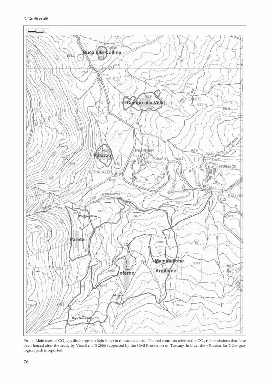
Fig. 3. Schematic representation of the November 19, 2003 eventat the Buca delle Colline dry-gas vent (after Tassi et alii 2009).
Fig. 2. The Buca alle Colline dry-gas vent from where in November 2003 a CO2 cloud killed a hunter and hisdog. The white arrow indicates the site where the hunter body was found. In June 2006, when the photo wastaken, an orange-colored smoker was directly set into the CO2 vent. In that moment, the meteorological con-ditions were not able to favor the accumulation of CO2 as shown by the height of the CO2 cloud (mimickedby the smoker) and by the presence of a person standing just above of the CO2 discharging spot.
O. Vaselli et alii
76
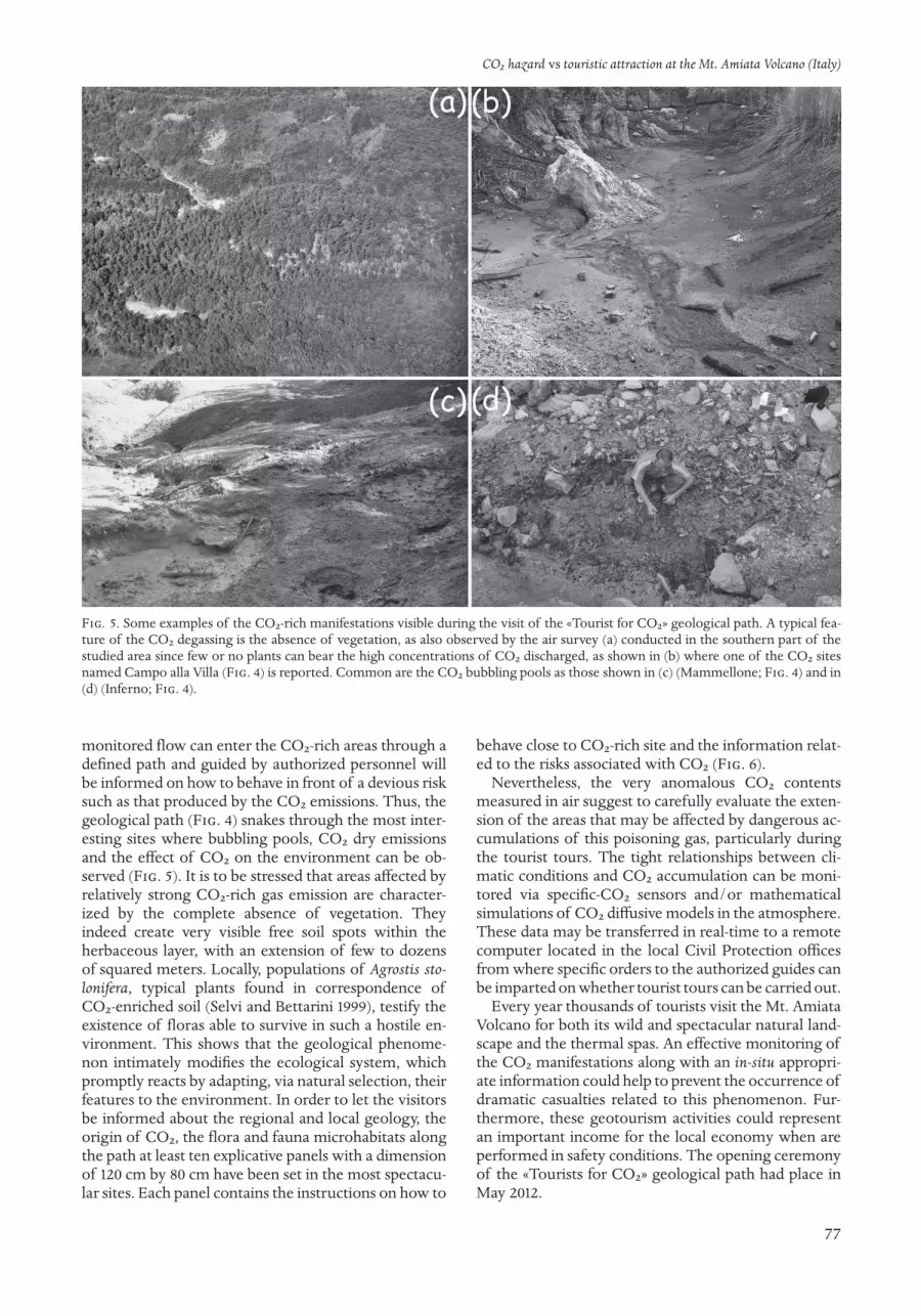
Fig. 4. Main sites of CO2 gas discharges (in light blue) in the studied area. The red contours refer to the CO2-rich emissions that havebeen fenced after the study by Vaselli et alii 2006 supported by the Civil Protection of Tuscany. In blue, the «Tourists for CO2» geo-logical path is reported.
CO2 hazard vs touristic attraction at the Mt. Amiata Volcano (Italy)
77
monitored flow can enter the CO2-rich areas through adefined path and guided by authorized personnel willbe informed on how to behave in front of a devious risksuch as that produced by the CO2 emissions. Thus, thegeological path (Fig. 4) snakes through the most inter-esting sites where bubbling pools, CO2 dry emissionsand the effect of CO2 on the environment can be ob-served (Fig. 5). It is to be stressed that areas affected byrelatively strong CO2-rich gas emission are character-ized by the complete absence of vegetation. They indeed create very visible free soil spots within theherbaceous layer, with an extension of few to dozensof squared meters. Locally, populations of Agrostis sto-lo nifera, typical plants found in correspondence ofCO2-enriched soil (Selvi and Bettarini 1999), testify the existence of floras able to survive in such a hostile en-vironment. This shows that the geological phenome-non intimately modifies the ecological system, whichpromptly reacts by adapting, via natural selection, theirfeatures to the environment. In order to let the visitorsbe informed about the regional and local geology, theorigin of CO2, the flora and fauna microhabitats alongthe path at least ten explicative panels with a dimensionof 120 cm by 80 cm have been set in the most spectacu-lar sites. Each panel contains the instructions on how to
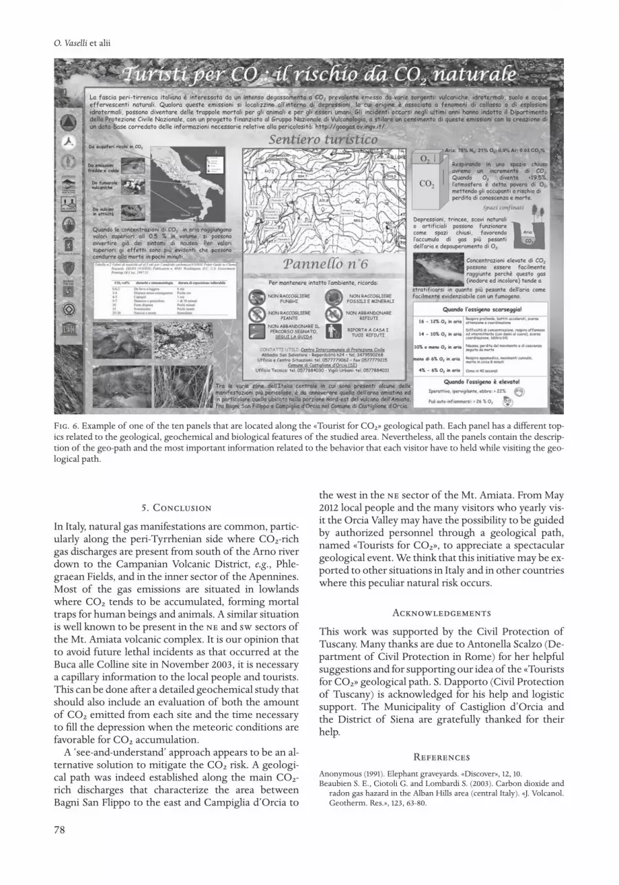
behave close to CO2-rich site and the information relat-ed to the risks associated with CO2 (Fig. 6).
Nevertheless, the very anomalous CO2 contentsmeasured in air suggest to carefully evaluate the exten-sion of the areas that may be affected by dangerous ac-cumulations of this poisoning gas, particularly duringthe tourist tours. The tight relationships between cli-matic conditions and CO2 accumulation can be moni-tored via specific-CO2 sensors and/or mathematicalsimulations of CO2 diffusive models in the atmosphere.These data may be transferred in real-time to a remotecomputer located in the local Civil Protection officesfrom where specific orders to the authorized guides canbe imparted on whether tourist tours can be carried out.
Every year thousands of tourists visit the Mt. AmiataVolcano for both its wild and spectacular natural land-scape and the thermal spas. An effective monitoring ofthe CO2 manifestations along with an in-situ appropri-ate information could help to prevent the occurrence ofdramatic casualties related to this phenomenon. Fur-thermore, these geotourism activities could representan important income for the local economy when areperformed in safety conditions. The opening ceremonyof the «Tourists for CO2» geological path had place inMay 2012.
Fig. 5. Some examples of the CO2-rich manifestations visible during the visit of the «Tourist for CO2» geological path. A typical fea-ture of the CO2 degassing is the absence of vegetation, as also observed by the air survey (a) conducted in the southern part of thestudied area since few or no plants can bear the high concentrations of CO2 discharged, as shown in (b) where one of the CO2 sitesnamed Campo alla Villa (Fig. 4) is reported. Common are the CO2 bubbling pools as those shown in (c) (Mammellone; Fig. 4) and in(d) (Inferno; Fig. 4).
O. Vaselli et alii
78
5. Conclusion
In Italy, natural gas manifestations are common, partic-ularly along the peri-Tyrrhenian side where CO2-richgas discharges are present from south of the Arno riverdown to the Campanian Volcanic District, e.g., Phle-graean Fields, and in the inner sector of the Apennines.Most of the gas emissions are situated in lowlandswhere CO2 tends to be accumulated, forming mortaltraps for human beings and animals. A similar situationis well known to be present in the ne and sw sectors ofthe Mt. Amiata volcanic complex. It is our opinion thatto avoid future lethal incidents as that occurred at theBuca alle Colline site in November 2003, it is necessarya capillary information to the local people and tourists.This can be done after a detailed geochemical study thatshould also include an evaluation of both the amountof CO2 emitted from each site and the time necessaryto fill the depression when the meteoric conditions arefavorable for CO2 accumulation.
A ‘see-and-understand’ approach appears to be an al-ternative solution to mitigate the CO2 risk. A geologi-cal path was indeed established along the main CO2-rich discharges that characterize the area betweenBagni San Flippo to the east and Campiglia d’Orcia to
the west in the ne sector of the Mt. Amiata. From May2012 local people and the many visitors who yearly vis-it the Orcia Valley may have the possibility to be guidedby authorized personnel through a geological path,named «Tourists for CO2», to appreciate a spectaculargeological event. We think that this initiative may be ex-ported to other situations in Italy and in other countrieswhere this peculiar natural risk occurs.
Acknowledgements
This work was supported by the Civil Protection ofTuscany. Many thanks are due to Antonella Scalzo (De-partment of Civil Protection in Rome) for her helpfulsuggestions and for supporting our idea of the «Touristsfor CO2» geological path. S. Dapporto (Civil Protectionof Tuscany) is acknowledged for his help and logisticsupport. The Municipality of Castiglion d’Orcia andthe District of Siena are gratefully thanked for theirhelp.
ReferencesAnonymous (1991). Elephant graveyards. «Discover», 12, 10.Beaubien S. E., Ciotoli G. and Lombardi S. (2003). Carbon dioxide and
radon gas hazard in the Alban Hills area (central Italy). «J. Volcanol.Geotherm. Res.», 123, 63-80.
Fig. 6. Example of one of the ten panels that are located along the «Tourist for CO2» geological path. Each panel has a different top-ics related to the geological, geochemical and biological features of the studied area. Nevertheless, all the panels contain the descrip-tion of the geo-path and the most important information related to the behavior that each visitor have to held while visiting the geo-logical path.
CO2 hazard vs touristic attraction at the Mt. Amiata Volcano (Italy)
79
Brogi A. (2007). The structure of the Monte Amiata volcano-geother-mal area (Northern Apennines, Italy): Neogene-Quaternary com-pression versus extension. «Int. J. Earth Sci.», 97, 677-703.
Calamai A., Castaldi R., Squarci P. and Taffi L. (1970). Geology, geo-physics and hydrogeology of the Monte Amiata geothermal fields.«Geothermics», 1, 1-95.
Cantrell L. and Young M. (2009). Fatal Fall into a Volcanic Fumarole.«Wildern. Environ. Med.», 20, 77-79.
Chiodini G. (2003). Relazione sull’incidente del 19 Novembre 2003, rela-zione congiunta ingv-Osservatorio Vesuviano e Dipartimento diScienze della Terra dell’Università degli Studi di Perugia, 9.
Chiodini G., Cardellini C., Amato A., Boschi E., Caliro S., Frondini F. andVentura G. (2004). Carbon dioxide Earth de-gassing and seismogen-esis in central and southern Italy. «Geophys. Res. Lett.», 31, L07615,doi:10.1029/2004GL019480.
Chiodini G., Frondini F., Cardellini C., Parello F. and Peruzzi L. (2000).Rate of diffuse carbon dioxide Earth degassing estimated from car-bon balance of regional aquifers: The case of central Apennine, Italy.«J. Geophys. Res.», 105, 8423-8434.
dcp-des 2008. Le emanazioni gassose nel Comune di Castiglioned’Orcia: il fenomeno naturale e le precauzioni da adottare, De-partment of Civil Protection (dcp) and Department of Earth Sci-ences (des) of the University of Florence, 12 (in Italian with Eng-lish abstract).
dcp-des 2008. Turisti per CO2. Amiata il respiro di un vulcano. TeleIdeaproduction, dvd, Department of Civil Protection (dcp) and Depart-ment of Earth Sciences (des) of the University of Florence (in Italian).
Ferrari L., Conticelli S., Burlamacchi L. and Manetti P. (1996). Vol-canological evolution of the Monte Amiata, Southern Tuscany: newgeological and petrochemical data. «Acta Vulcanologica», 8, 1, 41-56.
Frondini F., Caliro S., Cardellini C., Chiodini G. and Morgantini N.(2009). Carbon dioxide degassing and thermal energy release in theMonte Amiata volcanic-geothermal area (Italy). «Appl. Geochem.»,24, 860-875.
Gambardella B., Cardellini C., Chiodini G., Frondini F., Marini L., Ot-tonello G. and Vetuschi Zuccolini M. (2004). Fluxes of deep CO2 inthe volcanic areas of central-southern Italy. «J. Volcanol. Geotherm.Res.», 136, 31-52.
Gianelli G., Puxeddu M., Batini F., Bertini G., Dini I., Pandeli E. andNicolich E. (1988). Geological model of a young volcano-plutonicsystem: the geothermal region of Monte Amiata (Tuscany, Italy).«Geothermics», 17, 719-734.
Heggie T. W. (2009). Geotourism and volcanoes: health hazards facingtourists at volcanic and geothermal destinations. «Travel Med. Infect.Dis.», 7, 257-261.
Kerrick D. M. (2001). Present and past non-anthropogenic CO2 degassing from the solid Earth. «Rev. Geophys.», 39, 565-585.
Minissale A. (2004). Origin, transport and discharge of CO2 in centralItaly. «Earth Sci. Rev.», 66, 89-141.
Minissale A., Magro G., Vaselli O., Verrucchi C. and Perticone I. (1997).Geochemistry of water and gas discharges from the Mt. Amiata silicic complex and surrounding areas (central Italy). «J. Volcanol. Geotherm. Res.», 79, 223-251.
Rogie J. D., Kerrick D. M., Chiodini G. and Frondini F. (2000), Flux meas-urements of nonvolcanic CO2 emission from some vents in centralItaly. «J. Geophys. Res.», 105(B4), 8435-8445.
Selvi F. and Bettarini I. (1999). Geotermal biotopes in Central-WesternItaly from a botanical view point. In: A. Raschi, F. P. Vaccari and F.Miglietta (eds.), Ecosystem response to CO2: The maple Project re-sults, European Commission, Research D. G., Luxembourg, 1-12.
Smets B., Tedesco D., Kervin F., Kies A., Vaselli O. and Yalire M. M. (2010).Dry gas vents (“mazuku”) in Goma Region (North-Kivu, DemocraticRepublic of Congo): formation and risk assessment. «J. African EarthSciences», 58, 787-798, doi:10.1016/j.jafrearsci.2010.04.008.
Tassi F., Vaselli O., Cuccoli F., Buccianti A., Nisi B., Lognoli E. and Mon-tegrossi G. (2009). A geochemical multi-methodological approach inhazard assessment of CO2-rich gas emissions at Mt. Amiata volcano(Tuscany, central Italy). «Water, Air, Soil Poll. Focus», 9, 117-127.
Turner S. (2006). Promoting unesco Global Geoparks for sustainabledevelopment in the Australian-Pacifi region. «Acheringa», 31, 351-365.
Tuttle M. L., Lockwood J. P. and Evans W. C. (1990). Natural hazards as-sociated with Lake Kivu and adjoining areas of Birunga VolcanicField, Rwanda and Zaire, Central Africa. us Geological Survey Open-File Report 90-691, 46 pp.
Vaselli O., Capaccioni B., Tedesco D., Tassi F., Yalire M. M. and Kasare-ka M. C. (2002-2003). The “Evil’s Winds” (Mazukus) at Nyiragongovolcano (Democratic Republic of Congo). «Acta Vulcanologica», 14-15, 123-128.
Vaselli O., Cuccoli F., Buccianti A., Nisi B., Lognoli E., Lombardi L., Mo-retti S., Capannesi L., Ramaldi E., Tassi F., Montegrossi G., Capac-cioni B. and Minissale A. (2006). Le emanazioni gassose nel Comunedi Castiglione d’Orcia, relazione finale della Convenzione tra il Di-partimento della Protezione Civile della Regione Toscana e il Dipar-timento di Scienze della Terra dell’Università di Firenze, dicembre2005, 120.


Proprietà riservata · All rights reserved© Copyright 2012 by Fabrizio Serra editore®, Pisa · Roma.
Fabrizio Serra editore incorporates the Imprints Accademia editoriale,Edizioni dell’Ateneo, Fabrizio Serra editore, Giardini editori e stampatori in Pisa,
Gruppo editoriale internazionale and Istituti editoriali e poligrafici internazionali.
www.libraweb.net
Stampato in Italia · Printed in Italy
ISSN 1121-9114ISSN ELETTRONICO 1724-0425
CONTENTS
Orlando Vaselli, Bruno Capaccioni, Foreword 9Antonio Capponi, Danilo M. Palladino, Jacopo Taddeucci, Piergiorgio Scarlato, Parameterizing
the dynamics of Strombolian eruptions through high-speed video analysis 11Maurizio Mulas, Filippo Mundula, Raffaello Cioni, Stratigraphy of the rheomorphic, densely welded,
Monte Ulmus Ignimbrite (sw Sardinia, Italy) 17Chiara B. Cannata, Rosanna De Rosa, Bruce Houghton, Paola Donato, Andrea Nudo, Pele’s hair:
case studies from Kilauea Volcano and Vulcanello (Aeolian Islands) 27Rosario Raffaele, Luciano Scarfì, Martine Sapin, Mireille Laigle, Philippe Charvis, Jordi Diaz,
Sebastiano Imposa, Seismic activity in Central Lesser Antilles subduction zone from a combined on-/offshore net-work 35
Mariantonietta Longobardi, Luca D’Auria, Antonietta Maria Esposito, Relative location of hybridevents At Stromboli Volcano, Italy 39
Rossella Di Napoli, Alessandro Aiuppa, Elise Fourré, Philippe Jean-Baptiste, Francesco Parel-lo, Patrick Allard, Sergio Calabrese, Elyes Gaubi, Abdallah Ben Mamou, Mariano Valenza,Deep reservoir temperatures of low-enthalpy geothermal systems in Tunisia: new constraints from chemistry of ther-mal waters 43
Marco Doveri, Barbara Nisi, Andrea Cerrina Feroni, Alessandro Ellero, Matia Menichini,Matteo Lelli, Giulio Masetti, Simone Da Prato, Claudia Principe, Brunella Raco, Geological,hydrodynamic and geochemical features of the volcanic aquifer of Mt. Amiata (Tuscany, Central Italy): an overview 51
Orlando Vaselli, Barbara Nisi, Franco Tassi, Daniele Rappuoli, Valeria Pancioli, Simone Uc-ciero, Luciano Giannini, CO2 hazard vs touristic attraction at the Mt. Amiata Volcano (Italy) 73
Sebastian Vogel, gis-based geomorphometric analysis of Somma-Vesuvius volcanic complex: estimating the altitudeof Mt. Somma stratovolcano before its caldera-forming explosive activity 81
Conferences and Symposia 89


